Fairfield County | |
---|---|
Coordinates: 39°45′N82°38′W / 39.75°N 82.63°W | |
Country | United States |
State | Ohio |
Founded | December 9, 1800 [1] |
Named for | the Fairfield area of Lancaster, Lancashire, UK |
Seat | Lancaster |
Largest city | Lancaster |
Area | |
• Total | 509 sq mi (1,320 km2) |
• Land | 504 sq mi (1,310 km2) |
• Water | 4.2 sq mi (11 km2) 0.8% |
Population (2020) | |
• Total | 158,921 |
• Density | 310/sq mi (120/km2) |
Time zone | UTC−5 (Eastern) |
• Summer (DST) | UTC−4 (EDT) |
Congressional district | 12th |
Website | www |
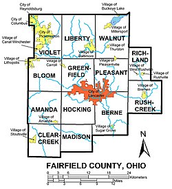
Fairfield County is a county located in the U.S. state of Ohio. As of the 2020 census, the population was 158,921. [2] Its county seat and largest city is Lancaster. [3] Its name is a reference to the Fairfield area of the original Lancaster. Fairfield County is part of the Columbus, OH Metropolitan Statistical Area.
Fairfield County originally encompassed all or parts of present day [update] Knox, Hocking, Licking, Perry, and Pickaway Counties. [4] Fairfield is a descriptive name referring to the beauty of their fields. [5]
According to the U.S. Census Bureau, the county has a total area of 509 square miles (1,320 km2), of which 504 square miles (1,310 km2) is land and 4.2 square miles (11 km2) (0.8%) is water. [6]
Fairfield County sits just on the edge of Ohio's Appalachian region. While the once-glaciated northern portion of the county is fairly flat, as one travels south along U.S. 33 one can easily recognize the foothills of a mountainous region beginning around the village of Carroll. Although not officially part of the state or federal definition of Appalachia, certain areas of Fairfield County—particularly those south of U.S. 22—bear a distinctly Appalachian feel in both physical geography and demographics.
The scenic Hocking Hills region lies immediately to the south, mostly in neighboring Hocking County. A large portion of Buckeye Lake is located in northeastern Fairfield County.
Mudhouse Mansion, an allegedly haunted house, was located in the county.
Census | Pop. | Note | %± |
---|---|---|---|
1810 | 11,361 | — | |
1820 | 16,633 | 46.4% | |
1830 | 24,786 | 49.0% | |
1840 | 31,924 | 28.8% | |
1850 | 30,264 | −5.2% | |
1860 | 30,538 | 0.9% | |
1870 | 31,138 | 2.0% | |
1880 | 34,284 | 10.1% | |
1890 | 33,939 | −1.0% | |
1900 | 34,259 | 0.9% | |
1910 | 39,201 | 14.4% | |
1920 | 40,484 | 3.3% | |
1930 | 44,010 | 8.7% | |
1940 | 48,490 | 10.2% | |
1950 | 52,130 | 7.5% | |
1960 | 63,912 | 22.6% | |
1970 | 73,301 | 14.7% | |
1980 | 93,678 | 27.8% | |
1990 | 103,461 | 10.4% | |
2000 | 122,759 | 18.7% | |
2010 | 146,156 | 19.1% | |
2020 | 158,921 | 8.7% | |
U.S. Decennial Census [7] 1790-1960 [8] 1900-1990 [9] 1990-2000 [10] 2020 [2] |
As of the census [11] of 2010, there were 146,156 people, 54,310 households, and 39,846 families living in the county. The population density was 289 inhabitants per square mile (112/km2). There were 58,678 housing units at an average density of 116 units per square mile (45/km2). The racial makeup of the county was 90.02% White, 6.00% Black or African American, 0.20% Native American, 1.10% Asian, 0.00% Pacific Islander, 0.23% from other races, and 1.90% from two or more races. 1.70% of the population were Hispanic or Latino of any race.
There were 54,310 households, out of which 34.10% had children under the age of 18 living with them, 57.30% were married couples living together, 11.20% had a female householder with no husband present, and 26.60% were non-families. 21.90% of all households were made up of individuals, and 8.40% had someone living alone who was 65 years of age or older. The average household size was 2.64 and the average family size was 3.07.
In the county, the population was spread out, with 26.30% under the age of 18, 8.00% from 18 to 24, 30.20% from 25 to 44, 23.90% from 45 to 64, and 12.40% who were 65 years of age or older. The median age was 38.2 years. For every 100 females, there were 99.20 males. For every 100 females age 18 and over, there were 96.30 males.
The median income for a household in the county was $47,962, and the median income for a family was $55,539. Males had a median income of $39,566 versus $27,353 for females. The per capita income for the county was $21,671. About 4.50% of families and 5.90% of the population were below the poverty line, including 7.40% of those under age 18 and 6.20% of those age 65 or over.
As of the 2010 United States Census, there were 146,156 people, 54,310 households, and 39,846 families living in the county. [12] The population density was 289.8 inhabitants per square mile (111.9/km2). There were 58,687 housing units at an average density of 116.3 units per square mile (44.9 units/km2). [13] The racial makeup of the county was 90.2% white, 6.0% black or African American, 1.1% Asian, 0.2% American Indian, 0.6% from other races, and 1.9% from two or more races. Those of Hispanic or Latino origin made up 1.7% of the population. [12] In terms of ancestry, 31.2% were German, 16.2% were Irish, 11.7% were English, 8.6% were American, and 5.2% were Italian. [14]
Of the 54,310 households, 37.3% had children under the age of 18 living with them, 57.3% were married couples living together, 11.2% had a female householder with no husband present, 26.6% were non-families, and 21.9% of all households were made up of individuals. The average household size was 2.64 and the average family size was 3.07. The median age was 38.2 years. [12]
The median income for a household in the county was $56,796 and the median income for a family was $65,835. Males had a median income of $49,314 versus $37,209 for females. The per capita income for the county was $26,130. About 7.5% of families and 10.4% of the population were below the poverty line, including 14.7% of those under age 18 and 6.7% of those age 65 or over. [15]
Year | Republican | Democratic | Third party(ies) | |||
---|---|---|---|---|---|---|
No. | % | No. | % | No. | % | |
2024 | 51,999 | 61.57% | 31,695 | 37.53% | 763 | 0.90% |
2020 | 50,797 | 60.97% | 31,224 | 37.48% | 1,290 | 1.55% |
2016 | 44,314 | 60.25% | 24,881 | 33.83% | 4,359 | 5.93% |
2012 | 41,034 | 56.82% | 29,890 | 41.39% | 1,296 | 1.79% |
2008 | 41,580 | 57.63% | 29,250 | 40.54% | 1,317 | 1.83% |
2004 | 42,715 | 62.93% | 24,783 | 36.51% | 384 | 0.57% |
2000 | 33,523 | 61.97% | 19,065 | 35.24% | 1,506 | 2.78% |
1996 | 26,850 | 52.98% | 18,821 | 37.13% | 5,013 | 9.89% |
1992 | 24,125 | 47.50% | 14,249 | 28.06% | 12,415 | 24.44% |
1988 | 29,208 | 69.46% | 12,504 | 29.74% | 339 | 0.81% |
1984 | 30,843 | 75.17% | 9,817 | 23.92% | 373 | 0.91% |
1980 | 24,096 | 60.98% | 13,144 | 33.26% | 2,275 | 5.76% |
1976 | 19,098 | 57.73% | 13,361 | 40.39% | 620 | 1.87% |
1972 | 21,909 | 71.67% | 7,746 | 25.34% | 913 | 2.99% |
1968 | 14,810 | 52.03% | 9,533 | 33.49% | 4,124 | 14.49% |
1964 | 11,480 | 42.38% | 15,611 | 57.62% | 0 | 0.00% |
1960 | 17,743 | 66.03% | 9,128 | 33.97% | 0 | 0.00% |
1956 | 15,647 | 65.24% | 8,337 | 34.76% | 0 | 0.00% |
1952 | 15,027 | 62.18% | 9,140 | 37.82% | 0 | 0.00% |
1948 | 9,471 | 50.09% | 9,375 | 49.58% | 61 | 0.32% |
1944 | 11,135 | 56.89% | 8,439 | 43.11% | 0 | 0.00% |
1940 | 10,813 | 48.90% | 11,298 | 51.10% | 0 | 0.00% |
1936 | 8,062 | 38.70% | 12,322 | 59.16% | 446 | 2.14% |
1932 | 8,050 | 43.04% | 10,410 | 55.66% | 244 | 1.30% |
1928 | 12,072 | 67.87% | 5,619 | 31.59% | 97 | 0.55% |
1924 | 8,281 | 53.80% | 5,890 | 38.26% | 1,222 | 7.94% |
1920 | 7,572 | 46.46% | 8,610 | 52.83% | 116 | 0.71% |
1916 | 3,380 | 34.69% | 6,172 | 63.34% | 192 | 1.97% |
1912 | 1,672 | 18.83% | 5,101 | 57.45% | 2,106 | 23.72% |
1908 | 4,023 | 40.24% | 5,821 | 58.22% | 154 | 1.54% |
1904 | 4,084 | 45.26% | 4,632 | 51.33% | 308 | 3.41% |
1900 | 3,738 | 40.14% | 5,431 | 58.32% | 144 | 1.55% |
1896 | 3,432 | 39.20% | 5,250 | 59.96% | 74 | 0.85% |
1892 | 3,004 | 37.83% | 4,650 | 58.56% | 287 | 3.61% |
1888 | 3,058 | 37.64% | 4,846 | 59.65% | 220 | 2.71% |
1884 | 3,210 | 38.94% | 4,922 | 59.70% | 112 | 1.36% |
1880 | 3,103 | 38.91% | 4,842 | 60.72% | 29 | 0.36% |
1876 | 2,770 | 37.57% | 4,597 | 62.36% | 5 | 0.07% |
1872 | 2,540 | 39.40% | 3,888 | 60.31% | 19 | 0.29% |
1868 | 2,439 | 37.44% | 4,076 | 62.56% | 0 | 0.00% |
1864 | 2,427 | 40.87% | 3,512 | 59.13% | 0 | 0.00% |
1860 | 2,178 | 37.66% | 3,249 | 56.18% | 356 | 6.16% |
1856 | 1,700 | 30.12% | 3,233 | 57.28% | 711 | 12.60% |
Prior to 1944, Fairfield County was Democratic in presidential elections, only voting for Republicans twice from 1856 to 1940. Starting with the 1944 election, the county has become a Republican stronghold in presidential elections, with Lyndon B. Johnson being the only Democrat to win since then, but Harry S. Truman came within 96 votes of winning it in 1948.
Roster of County Officials (as of Feb. 2019):
School districts include: [17]
Source: [18]
Lancaster is a city in and the county seat of Fairfield County, Ohio, in the south-central part of the state. As of the 2020 census, the city population was 40,552. The city is near the Hocking River, about 33 miles (53 km) southeast of Columbus and 38 miles (61 km) southwest of Zanesville. It is part of the Columbus metropolitan area.
Ross County is a county in the Appalachian region of the U.S. state of Ohio. As of the 2020 United States Census, the population was 77,093. Its county seat is Chillicothe, the first and third capital of Ohio. Established on August 20, 1798, the county is named for Federalist Senator James Ross of Pennsylvania. Ross County comprises the Chillicothe, OH Micropolitan Statistical Area, which is also included in the Columbus-Marion-Zanesville, OH Combined Statistical Area.
Pickaway County is a county in the U.S. state of Ohio. As of the 2020 census, the population was 58,539. Its county seat is Circleville. Its name derives from the Pekowi band of Shawnee Indians, who inhabited the area.
Madison County is a county located in the central portion of the U.S. state of Ohio. As of the 2020 census, the population was 43,824. Its county seat is London. The county is named for James Madison, President of the United States and was established on March 1, 1810. Madison County is part of the Columbus, OH Metropolitan Statistical Area.
Hocking County is a county located in the U.S. state of Ohio. As of the 2020 census, the population was 28,050. Its county seat is Logan. The county was organized on March 1, 1818, from land given by Athens, Fairfield, and Ross counties. Its name is from the Hocking River, the origins of which are disputed but is said to be a Delaware Indian word meaning "bottle river". Hocking County is included in the Columbus, OH Metropolitan Statistical Area.
Butler County is a county located in the southwestern part of the U.S. state of Ohio. As of the 2020 census, the population was 390,357. Its county seat and largest city is Hamilton. It is named for General Richard Butler, who died in 1791 during St. Clair's Defeat. Located along the Great Miami River, it is also home to Miami University, a public university founded in 1809. Butler County is part of the Cincinnati, OH-KY-IN Metropolitan Statistical Area. The majority of the county is in District 52 of the State House.
Athens County is a county in southeastern Ohio. As of the 2020 census, the population was 62,431. Its county seat and largest city is Athens. The county was formed in 1805 from Washington County. Because Ohio's first state university, Ohio University, was established here in 1804, the town and the county are named for the ancient center of learning, Athens, Greece.
Amanda is a village in Fairfield County, Ohio, United States. The population was 637 at the 2020 census.
Bremen is a village in Fairfield County, Ohio, United States. The population was 1,479 at the 2020 census.
Carroll is a village in Fairfield County, Ohio, United States. The population was 501 at the 2020 census.
Stoutsville is a village in Fairfield County, Ohio, United States. The population was 579 at the 2020 census.
Leesburg is a village in Highland County, Ohio, United States. The population was 1,273 at the 2020 census.
Laurelville is a village in Hocking County, Ohio, United States. The population was 512 at the 2020 census.
Somerset is a village in Perry County, Ohio, United States. The population as of the 2020 census was 1,481. It is located 9.5 miles north of the county seat New Lexington and has a dedicated historical district. Saint Joseph Church, the oldest Catholic church in Ohio, is located just outside Somerset on State Route 383.
Circleville is a city in and the county seat of Pickaway County, Ohio, United States. The city is situated along the Scioto River, 25 miles (40 km) south of Columbus. The population was recorded to be 13,927 in the 2020 census.
Commercial Point is a village in Pickaway County, Ohio, United States. The population was 3,078 at the 2020 census. It is one of the fastest-growing villages in central Ohio. It is a suburb of Columbus.
Pickerington is a city in Fairfield and Franklin counties in the central region of the U.S. state of Ohio. It is a suburb of Columbus. The population was 23,094 at the 2020 census. It was founded in 1815 as Jacksonville, named after Andrew Jackson. The name was changed in 1827 in honor of its founder, Abraham Pickering. As land annexation, development, and immigration into the Columbus area continues, the city of Pickerington has generally followed suit. Pickerington is home to the Motorcycle Hall of Fame, located off of Interstate 70.
Hocking Township is one of the thirteen townships of Fairfield County, Ohio, United States. As of the 2020 census the population was 4,850.
Clearcreek Township is one of the thirteen townships of Fairfield County, Ohio, United States. As of the 2020 census the population was 4,084.
Eastland-Fairfield Career & Technical Schools (EFCTS), formerly Eastland Vocational Center (1968–2001), is a joint career & technical school district in Ohio. It serves 16 school districts in Franklin, Fairfield, and Pickaway counties. It covers an area of 700 square miles (1,813 km2), and is one of the largest career and technical districts geographically in Ohio.