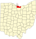
Erie County is a county in the northern portion of the U.S. state of Ohio. As of the 2020 census, the population was 75,622.[2] Its county seat and largest city is Sandusky.[3] The county is named for the Erie tribe, whose name was their word for "wildcat".[4] It was formed in 1838 from the northern third of Huron County and a portion of Sandusky County.
Erie County was created in 1838 from a portion of Huron County. A few subsequent changes to Erie County's boundaries occurred shortly after its initial formation.[6]
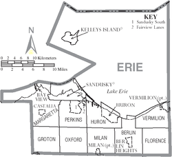
Geography
According to the U.S. Census Bureau, the county has a total area of 626 square miles (1,620km2), of which 252 square miles (650km2) is land and 374 square miles (970km2) (60%) is water.[7] It is the second-smallest county in Ohio by land area after Lake County. The county is bordered on the north by Lake Erie; the opposite shore is made up of two counties in Ontario, Canada.
It is drained by the Huron and Vermilion rivers. Near the Huron River are several ancient earthwork mounds and enclosures constructed by early indigenous peoples. Sandusky has extensive quarries of valuable limestone. The surface is generally level, and the soil alluvial and exceedingly fertile.[8]
U.S. Decennial Census[9] 1790-1960[10] 1900-1990[11] 1990-2000[12] 2020 [2]
2020 census
As of the 2020 census, the county had a population of 75,622. The median age was 46.1 years, 20.0% of residents were under the age of 18, and 23.6% of residents were 65 years of age or older. For every 100 females there were 96.2 males, and for every 100 females age 18 and over there were 94.5 males age 18 and over.[13]
71.8% of residents lived in urban areas, while 28.2% lived in rural areas.[15]
There were 32,360 households in the county, of which 24.8% had children under the age of 18 living in them. Of all households, 44.3% were married-couple households, 19.6% were households with a male householder and no spouse or partner present, and 28.5% were households with a female householder and no spouse or partner present. About 31.8% of all households were made up of individuals and 14.8% had someone living alone who was 65 years of age or older.[13]
There were 38,262 housing units, of which 15.4% were vacant. Among occupied housing units, 68.5% were owner-occupied and 31.5% were renter-occupied. The homeowner vacancy rate was 1.6% and the rental vacancy rate was 8.5%.[13]
Racial and ethnic composition
Erie County, Ohio – Racial and ethnic composition Note: the US Census treats Hispanic/Latino as an ethnic category. This table excludes Latinos from the racial categories and assigns them to a separate category. Hispanics/Latinos may be of any race.
As of the 2010 United States census, there were 77,079people, 31,860households, and 21,011families residing in the county.[25] The population density was 306.4 inhabitants per square mile (118.3/km2). There were 37,845 housing units at an average density of 150.4 unitsper square mile (58.1 units/km2).[26] The racial makeup of the county was 87.0% white, 8.6% black or African American, 0.6% Asian, 0.3% American Indian, 0.7% from other races, and 2.8% from two or more races. Those of Hispanic or Latino origin made up 3.4% of the population.[25] In terms of ancestry, 38.8% were German, 15.2% were Irish, 11.7% were English, 8.5% were Italian, and 4.6% were American.[27]
Of the 31,860households, 29.1% had children under the age of 18 living with them, 48.5% were married couples living together, 12.9% had a female householder with no husband present, 34.1% were non-families, and 28.6% of all households were made up of individuals. The average household size was 2.37 and the average family size was 2.89. The median age was 43.4 years.[25]
The median income for a household in the county was $46,593 and the median income for a family was $61,247. Males had a median income of $46,211 versus $32,621 for females. The per capita income for the county was $25,290. About 8.5% of families and 12.5% of the population were below the poverty line, including 17.1% of those under age 18 and 8.5% of those age 65 or over.[28]
2000 census
As of the census[29] of 2000, there were 79,551 people, 31,727 households, and 21,764 families residing in the county. The population density was 312 inhabitants per square mile (120/km2). There were 35,909 housing units at an average density of 141 unitsper square mile (54/km2). The racial makeup of the county was 88.64% White, 8.64% Black or African American, 0.21% Native American, 0.37% Asian, 0.01% Pacific Islander, 0.53% from other races, and 1.60% from two or more races. 2.09% of the population were Hispanic or Latino of any race. 35.7% were of German, 9.2% Irish, 8.2% English, 8.1% Italian, and 7.8% American ancestry according to Census 2000.
There were 31,727 households, out of which 30.40% had children under the age of 18 living with them, 53.70% were married couples living together, 11.20% had a female householder with no husband present, and 31.40% were non-families. 27.00% of all households were made up of individuals, and 10.80% had someone living alone who was 65 years of age or older. The average household size was 2.45 and the average family size was 2.97.
In the county, the population was spread out, with 24.70% under the age of 18, 7.20% from 18 to 24, 27.00% from 25 to 44, 25.50% from 45 to 64, and 15.60% who were 65 years of age or older. The median age was 40 years. For every 100 females there were 95.00 males. For every 100 females age 18 and over, there were 92.40 males.
The median income for a household in the county was $42,746, and the median income for a family was $51,756. Males had a median income of $39,249 versus $23,697 for females. The per capita income for the county was $21,530. About 6.00% of families and 8.30% of the population were below the poverty line, including 11.60% of those under age 18 and 6.80% of those age 65 or over.
Patrick Shenigo is the Chairman of the Erie County Commission, the highest elected position in the county.
From 1992 to 2012, Erie County consistently voted Democratic. In 2016, however, it swung from a 12.3% margin for Barack Obama to a 9.5% margin for Donald Trump, tracking with Trump's unexpectedly strong showing in the Rust Belt. Trump further increased his margin of victory to 11.5% in 2020. In 2024, Trump won the highest percentage of the vote in the county since 1984.
United States presidential election results for Erie County, Ohio[30]
Erie County's courthouse at 323 Columbus Avenue in Sandusky was built in 1872 by Cleveland architects Myer and Holmes in a richly ornamented Second Empire style. Most of the façade was remodeled beginning in 1936 in Art Deco in a WPA project led locally by architect Henry Millott. Some of the original façade remains visible around the bottom row of windows.[34]
Education
All or part of eleven school districts serve Erie County and its residents:
This page is based on this Wikipedia article Text is available under the CC BY-SA 4.0 license; additional terms may apply. Images, videos and audio are available under their respective licenses.