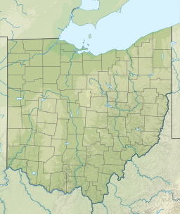
Lake Erie is the fourth-largest lake by surface area of the five Great Lakes in North America and the eleventh-largest globally. It is the southernmost, shallowest, and smallest by volume of the Great Lakes and also has the shortest average water residence time. At its deepest point Lake Erie is 210 feet (64 m) deep.

The Castalian Spring, in the ravine between the Phaedriades at Delphi, is where all visitors to Delphi — the contestants in the Pythian Games, and especially pilgrims who came to consult the Delphic Oracle — stopped to wash themselves and quench their thirst; it is also here that the Pythia and the priests cleansed themselves before the oracle-giving process. Finally Roman poets regarded it as a source of poetic inspiration. According to some mythological versions it was here that Apollo killed the monster, Python, who was guarding the spring, and that is why it was considered to be sacred.

Erie County is a county located in the northern portion of the U.S. state of Ohio. As of the 2020 census, the population was 75,622. Its county seat and largest city is Sandusky. The county is named for the Erie tribe, whose name was their word for "wildcat". It was formed in 1838 from the northern third of Huron County and a portion of Sandusky County.
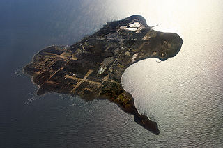
Kelleys Island is both a village in Erie County, Ohio, and the island which it fully occupies in Lake Erie. The British originally called it Sandusky Island. Later the United States took it over and officially designated it as Island Number 6 and Cunningham Island. It was renamed as Kelleys Island in 1840 by brothers Datus and Irad Kelley, who had purchased nearly the entire island.
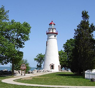
Marblehead is a village in Ottawa County, Ohio, United States. The population was 865 at the 2020 census. It sits at the tip of the Marblehead Peninsula, which divides Lake Erie proper from Sandusky Bay. Marblehead is part of the area that is referred to regionally as Vacationland due to the large number of tourists who flock to the area in the summer months. It remains a popular vacation destination due to its lake frontage, ferry service to the Lake Erie Islands, quality sport fishery, the nearby Lakeside Chautauqua, and the Cedar Point amusement park. Marblehead is also home to the Lakeside Daisy State Nature Preserve, home to the only natural U.S. population of the Lakeside Daisy, an endangered species.

A sinkhole is a depression or hole in the ground caused by some form of collapse of the surface layer. The term is sometimes used to refer to doline, enclosed depressions that are locally also known as vrtače and shakeholes, and to openings where surface water enters into underground passages known as ponor, swallow hole or swallet. A cenote is a type of sinkhole that exposes groundwater underneath. Sink and stream sink are more general terms for sites that drain surface water, possibly by infiltration into sediment or crumbled rock.

A cenote is a natural pit, or sinkhole, resulting from the collapse of limestone bedrock that exposes groundwater. The term originated on the Yucatán Peninsula of Mexico, where cenotes were commonly used for water supplies by the ancient Maya, and occasionally for sacrificial offerings. The term derives from a word used by the lowland Yucatec Maya—tsʼonoʼot—to refer to any location with accessible groundwater.

The Great Blue Hole is a giant marine sinkhole off the coast of Belize. It lies near the center of Lighthouse Reef, a small atoll 70 km (43 mi) from the mainland and Belize City. The hole is circular in shape, 318 m (1,043 ft) across and 124 m (407 ft) deep. It has a surface area of 70,650 square metres (760,500 sq ft). It was formed during several episodes of quaternary glaciation when sea levels were much lower. Analysis of stalactites found in the Great Blue Hole shows that formation took place 153,000; 66,000; 60,000; and 15,000 years ago. As the ocean began to rise again, the cave was flooded. The Great Blue Hole is a part of the larger Belize Barrier Reef Reserve System, a UNESCO World Heritage Site.

Dzibilchaltún is a Maya archaeological site in the Mexican state of Yucatán, approximately 10 miles (16 km) north of state capital of Mérida.

Dos Ojos is part of a flooded cave system located north of Tulum, on the Caribbean coast of the Yucatán Peninsula, in the state of Quintana Roo, Mexico. The exploration of Dos Ojos began in 1987 and still continues. The surveyed extent of the cave system is 82 kilometers (51 mi) and there are 28 known sinkhole entrances, which are locally called cenotes. In January 2018, a connection was found between Sistema Dos Ojos and Sistema Sac Actun. The smaller Dos Ojos became a part of Sac Actun, making the Sistema Sac Actun the longest known underwater cave system in the world.
Erie MetroParks was formed as the "Erie County Metropolitan Park District" in 1968 and adopted its current name in 1991. It consists of 14 individual park areas located throughout Erie County in the US state of Ohio covering approximately 3,200 acres (1,300 ha).
A blue hole is a submarine cave or sinkhole. It may also refer to:

Sandusky is a city in and the county seat of Erie County, Ohio, United States. Situated along the shores of Lake Erie in the northern part of the state, Sandusky is located roughly midway between Toledo and Cleveland. According to 2020 census, the city had a population of 25,095, and the Sandusky micropolitan area had 75,622 residents.

Ewens Ponds is a series of three water-filled limestone sinkholes in the Australian state of South Australia located in the gazetted locality of Eight Mile Creek, on the watercourse of Eight Mile Creek about 25 kilometres south of Mount Gambier and 8.4 kilometres east of Port Macdonnell. The ponds are popular with recreational divers due to underwater visibility of up to 80 metres. It has a large fish population including the endangered golden pygmy perch. Ewens Ponds has been part of the Ewens Ponds Conservation Park since 1976.
The Blue Hole of Santa Rosa, or simply the Blue Hole, is a circular, bell-shaped pool or small lake located along Route 66 east of Santa Rosa, New Mexico that is a tourist attraction and swimming venue, and one of the most popular dive destinations in the US for scuba diving and training. The Blue Hole is an artesian well and cenote that was once used as a fish hatchery.
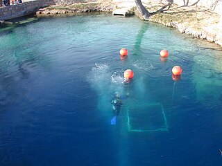
Little Blue Lake is a water-filled sinkhole (“cenote”) in the Australian state of South Australia located in the state's south-east in the locality of Mount Schank about 20 kilometres (12 mi) south of the municipal seat of Mount Gambier. It is notable locally as a swimming hole and nationally as a cave diving site. It is managed by the District Council of Grant and has been developed as a recreational and tourism venue.

The Vacationland region of Ohio—billed as such for being known primarily as a major summertime tourist destination—is the area that is generally considered to be in the north central part of the state, and along the western half of the Lake Erie shoreline around Sandusky Bay, specifically the counties of Erie, Huron, Ottawa, and Sandusky.
The 1973 Mount Gambier cave diving accident was a scuba diving incident on 28 May 1973 at a flooded sinkhole known as "The Shaft" near Mount Gambier in South Australia. The incident claimed the lives of four recreational scuba divers: siblings Stephen and Christine M. Millott, Gordon G. Roberts, and John H. Bockerman. The four divers explored beyond their own planned limits, without the use of a guideline, and subsequently became lost, eventually exhausting their breathing air and drowning. As of May 2015, they are the only known fatalities at the site. Four other divers from the same group survived.