Oxford Township, Erie County, Ohio

Last updated

Oxford Township, Erie County, Ohio
Darkness at the Bend in the River.JPG
Along the West Branch of the Huron River in southeastern Oxford Township
Oxford Erie.PNG
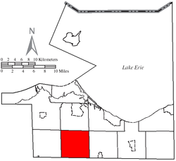
Location of Oxford Township in Erie County
Coordinates: 41°19′43″N82°41′16″W / 41.32861°N 82.68778°W / 41.32861; -82.68778
Country United States
State Ohio
County Erie
Area
  Total26.1 sq mi (67.6 km2)
  Land26.0 sq mi (67.4 km2)
  Water0.1 sq mi (0.3 km2)
Elevation
[1]
696 ft (212 m)
Population
 (2020) [2]
  Total1,140
  Density44/sq mi (17/km2)
Time zone UTC-5 (Eastern (EST))
  Summer (DST) UTC-4 (EDT)
FIPS code 39-59276 [3]
GNIS feature ID1086068 [1]
Website http://www.oxfordtownshipohio.com/

Oxford Township is one of the nine townships of Erie County, Ohio, United States. It is part of the Sandusky, Ohio micropolitan statistical area and the Cleveland-Akron-Canton Combined Statistical Area. The 2020 census recorded 1,140 residents.

Contents

A small section of NASA Glenn Research Center's Plum Brook Station facility is located in Oxford Township. Most notably, the Space Power Facility (SPF)---the world's largest thermal vacuum chamber---is located in the northeastern corner of the township.

Geography

Located in the southwestern part of Erie County, it borders the following townships:

No municipalities are located in Oxford Township, although the unincorporated community of Bloomingville lies in the northern part of the township.

Oxford Township is part of the Firelands, which in turn is part of the Connecticut Western Reserve.

Topography

Farm fields and woodlots are a common scene across Oxford Township. Across the River in the Valley, Oxford Township, Erie County, Ohio.jpg
Farm fields and woodlots are a common scene across Oxford Township.

Oxford Township lies within two river watersheds, both flowing into Lake Erie. The majority of the township is within the Huron River watershed while the northwestern area of the township is within the Sandusky Bay watershed. [4]

The majority of the topography of the township includes extremely flat to slightly rolling land; farm fields and small woodlots are in abundance. In the far southeast portion of the township, however, the topography becomes rugged with steep cliffs and dense woods near the west branch of the Huron River. Some of the cliffs are over 100 feet (30 m) high. There are even some small waterfalls near Peru Center Road and Schaffer Road that are approximately 75 feet (23 m) high.

Two state natural areas are located within this township. Erie Sand Barrens State Nature Preserve, a 32-acre (130,000 m2) park in the northwest part of the township, can be accessed from Mason Road and Taylor Road. [5] The 296-acre (1.20 km2) Milan State Wildlife Area in the southeast part of the township can be accessed from State Route 113 and Lovers Lane. [6]

Name and history

Oxford Township is one of only thirty townships located in a unique subregion of the Connecticut Western Reserve, known as the Firelands. Established in 1792, this half-million-acre tract of land (originally known as the Fire Sufferers Land) was given by the Connecticut Legislature to the citizens of towns which were invaded and damaged by British troops during the American Revolutionary War. [7]

It is one of six Oxford Townships statewide. [8]

Government

Regional and national government

Local government

The township is governed by a three-member board of trustees, who are elected in November of odd-numbered years to a four-year term beginning on the following January 1. Two are elected in the year after the presidential election and one is elected in the year before it. There is also an elected township fiscal officer, [9] who serves a four-year term beginning on April 1 of the year after the election, which is held in November of the year before the presidential election. Vacancies in the fiscal officership or on the board of trustees are filled by the remaining trustees.

Public services

Transportation

An early winter view from Ransom Road just south of NASA Plum Brook Station in Oxford Township. Ransom Road Early Winter.JPG
An early winter view from Ransom Road just south of NASA Plum Brook Station in Oxford Township.

The Ohio Turnpike passes through Oxford Township, as does Ohio State Routes 99 and 113. Other important county and township highways include Mason Road, Patten Tract Road, Ransom Road, Strecker Road, and Thomas Road.

Communication

Addresses in Oxford Township have several different ZIP codes:

Telephone numbers in Oxford Townships have one of two area codes, either 419 or 567.

Education

Children from Oxford Townships attend one of three different public school districts:

Parochial schools are located in the nearby towns of Monroeville, Norwalk, and Sandusky.

Safety

Residents are protected by the Erie County Sheriff's Department, North Central EMS, and one of two volunteer fire departments: the Groton Township fire department, for residents in the western part of the township; [10] and the Milan Township fire department, for residents in the eastern part of the township.

Related Research Articles

<span class="mw-page-title-main">Huron County, Ohio</span> County in Ohio, United States

Huron County is a county located in the U.S. state of Ohio. As of the 2020 census, the population was 58,565. Its county seat is Norwalk. The county was created in 1809 and later organized in 1815.

<span class="mw-page-title-main">Erie County, Ohio</span> County in Ohio, United States

Erie County is a county located in the northern portion of the U.S. state of Ohio. As of the 2020 census, the population was 75,622. Its county seat and largest city is Sandusky. The county is named for the Erie tribe, whose name was their word for "wildcat". It was formed in 1838 from the northern third of Huron County and a portion of Sandusky County.

<span class="mw-page-title-main">Huron, Ohio</span> City in Ohio, United States

Huron is a city in Erie County, Ohio, United States, located at the mouth of the Huron River on Lake Erie. The population was 6,922 at the 2020 census. It is part of the Sandusky micropolitan area.

<span class="mw-page-title-main">Norwalk, Ohio</span> City in Ohio, United States

Norwalk is a city in and the county seat of Huron County, Ohio, United States. The population was 17,068 at the 2020 census. The city is the center of the Norwalk micropolitan area and part of the Cleveland–Akron–Canton combined statistical area. Norwalk is located approximately 10 miles (16 km) south of Lake Erie, 51 miles (82 km) west/southwest of Cleveland, 59 miles (95 km) southeast of Toledo, and 58 miles (93 km) west/northwest of Akron.

<span class="mw-page-title-main">Firelands</span>

The Firelands, or Sufferers' Lands, tract was located at the western end of the Connecticut Western Reserve in what is now the U.S. state of Ohio. It was legislatively established in 1792, as the "Sufferers' Lands", and later became named "Fire Lands" because the resale of the land was intended as financial restitution for residents of the Connecticut towns of Danbury, Fairfield, Greenwich, Groton, New Haven, New London, Norwalk, and Ridgefield. Their homes had been burned in 1779 and 1781 by British forces during the American Revolutionary War. However, most of the settlement of the area did not occur until after the War of 1812. "Fire Lands" was later spelled as one word: "Firelands."

<span class="mw-page-title-main">Huron River (Ohio)</span> River in the United States

The Huron River is a 14.9-mile-long (24.0 km) waterway in the north central Ohio in the United States. The watershed drains large portions of Erie County and Huron County, the northeast corners of Seneca County and Crawford County, and northern portions of Richland County.

<span class="mw-page-title-main">Danbury Township, Ottawa County, Ohio</span> Township in Ohio, United States

Danbury Township is one of the twelve townships of Ottawa County, Ohio, United States. The 2020 census found 4,924 people in the township.

<span class="mw-page-title-main">Perkins Township, Erie County, Ohio</span> Township in Ohio, United States

Perkins Township is one of the nine townships of Erie County, Ohio, United States. It is part of the Sandusky, Ohio metropolitan statistical area. As of the 2020 census the population was 12,390.

<span class="mw-page-title-main">Berlin Township, Erie County, Ohio</span> Township in Ohio, United States

Berlin Township is one of the nine townships of Erie County, Ohio, United States. It is part of the Sandusky, Ohio metropolitan statistical area. As of the 2020 census the population was 3,450.

<span class="mw-page-title-main">Groton Township, Erie County, Ohio</span> Township in Ohio, United States

Groton Township is one of the nine townships of Erie County, Ohio, United States. It is part of the Sandusky, Ohio metropolitan statistical area. As of the 2020 census the population was 1,379.

<span class="mw-page-title-main">Huron Township, Erie County, Ohio</span> Township in Ohio, United States

Huron Township is one of the nine townships of Erie County, Ohio, United States. It is part of the Sandusky, Ohio metropolitan statistical area, with the city of Sandusky to the northwest. The township sits along the southwestern shoreline of Lake Erie, one of the Great Lakes. As of the 2020 census the population was 10,724.

<span class="mw-page-title-main">Margaretta Township, Erie County, Ohio</span> Township in Ohio, United States

Margaretta Township is one of the nine townships of Erie County, Ohio, United States. It is part of the Sandusky, Ohio metropolitan statistical area. As of the 2020 census the population was 5,640.

<span class="mw-page-title-main">Milan Township, Erie County, Ohio</span> Township in Ohio, United States

Milan Township is one of the nine townships of Erie County, Ohio, United States. It is part of the Sandusky, Ohio metropolitan statistical area, which is also the county seat of Erie County. As of the 2020 census 3,580 people lived in the township.

<span class="mw-page-title-main">Lyme Township, Huron County, Ohio</span> Township in Ohio, United States

Lyme Township is one of the nineteen townships of Huron County, Ohio, United States. As of the 2020 census the population of the township was 873.

<span class="mw-page-title-main">Norwalk Township, Huron County, Ohio</span> Township in Ohio, United States

Norwalk Township is one of the nineteen townships of Huron County, Ohio, United States. As of the 2020 census the population of the township was 3,451.

<span class="mw-page-title-main">Ridgefield Township, Huron County, Ohio</span> Township in Ohio, United States

Ridgefield Township is one of the nineteen townships of Huron County, Ohio, United States. As of the 2020 census the population was 2,197.

<span class="mw-page-title-main">Townsend Township, Huron County, Ohio</span> Township in Ohio, United States

Townsend Township is one of the nineteen townships of Huron County, Ohio, United States. As of the 2020 census the population of the township was 1,571.

<span class="mw-page-title-main">Ruggles Township, Ashland County, Ohio</span> Township in Ohio, United States

Ruggles Township is one of the fifteen townships of Ashland County, Ohio, United States. The population was 955 at the 2020 census.

<span class="mw-page-title-main">Avery, Ohio</span>

Avery is an unincorporated community in western Milan Township, Erie County, Ohio, United States. It is part of the Sandusky Metropolitan Statistical Area. Avery is located along US Route 250 near that road's interchange with Interstate 80 and Interstate 90, the Ohio Turnpike. The area is characterized by hotels and some industry. It once had a post office, but is now included in the Milan, Ohio postal zone (44846).

<span class="mw-page-title-main">Firelands Conference</span>

The Firelands Conference is an Ohio High School Athletic Association (OHSAA) athletic league located in north-central Ohio. The league was formed in the 1960–61 school year and is named for the Firelands area of the old Western Reserve, where most of the member schools reside. High schools in this conference are located in Ashland, Huron, and Richland counties. Some of the schools' district boundaries extend into the neighboring counties of Crawford, Erie, and Lorain. Most of the founding schools came from the defunct Huron-Erie League.

References

  1. 1 2 "US Board on Geographic Names". United States Geological Survey. October 25, 2007. Retrieved January 31, 2008.
  2. "Oxford township, Erie County, Ohio - Census Bureau Profile". United States Census Bureau. Retrieved June 26, 2023.
  3. "U.S. Census website". United States Census Bureau . Retrieved January 31, 2008.
  4. "Lake Erie Watershed" (Map). www.ohiodnr.com. Retrieved December 15, 2009.
  5. "Erie Sand Barrens". www.dnr.state.oh.us. Archived from the original on April 21, 2008. Retrieved December 15, 2009.
  6. "Milan Wildlife Area". www.dnr.state.oh.us. Archived from the original on September 17, 2008. Retrieved December 15, 2009.
  7. "Firelands Historical Society ~Gallery~". firelandsmuseum.org. Archived from the original on February 10, 2009. Retrieved December 15, 2009.{{cite web}}: CS1 maint: unfit URL (link)
  8. "Detailed map of Ohio" (PDF). United States Census Bureau. 2000. Retrieved February 16, 2007.
  9. §503.24, §505.01, and §507.01 of the Ohio Revised Code. Accessed 4/30/2009.
  10. Groton Township Volunteer Fire Department - History Page Accessed 04 December 2009.