Whites Landing, Ohio

Last updated

Whites Landing, Ohio
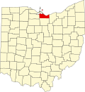
USA Ohio location map.svg
Red pog.svg
Whites Landing
Coordinates: 41°25′47″N82°54′3″W / 41.42972°N 82.90083°W / 41.42972; -82.90083
Country United States
State Ohio
Counties Erie, Sandusky
Townships Margaretta, Townsend
Area
[1]
  Total0.29 sq mi (0.76 km2)
  Land0.29 sq mi (0.76 km2)
  Water0.00 sq mi (0.00 km2)
Elevation
[2]
580 ft (180 m)
Population
 (2020)
  Total350
  Density1,194.54/sq mi (461.29/km2)
Time zone UTC-5 (Eastern (EST))
  Summer (DST) UTC-4 (EDT)
Area code 419 / 567
FIPS code 39-84882 [3]
GNIS feature ID1049326 [2]

Whites Landing is an unincorporated community and census-designated place in Erie and Sandusky counties, Ohio, United States. As of the 2020 census it had a population of 350. It is located within Margaretta and Townsend townships.

Contents

Geography

Whites Landing is located on the border between Erie and Sandusky counties, on the south shore of Sandusky Bay, an arm of Lake Erie. It is 11 miles (18 km) west of the city of Sandusky and 14 miles (23 km) northeast of Fremont.

Demographics

Historical population
CensusPop.Note
2020 350
U.S. Decennial Census [4]

Related Research Articles

<span class="mw-page-title-main">Sandusky County, Ohio</span> County in Ohio, United States

Sandusky County is a county located in the northwestern part of the U.S. state of Ohio. It is southeast of the Toledo Metropolitan Area. As of the 2020 census, the population was 58,896. Its county seat is Fremont. The county was formed on February 12, 1820, from portions of Huron County.

<span class="mw-page-title-main">Erie County, Ohio</span> County in Ohio, United States

Erie County is a county located in the northern portion of the U.S. state of Ohio. As of the 2020 census, the population was 75,622. Its county seat and largest city is Sandusky. The county is named for the Erie tribe, whose name was their word for "wildcat". It was formed in 1838 from the northern third of Huron County and a portion of Sandusky County.

<span class="mw-page-title-main">Huron, Ohio</span> City in Ohio, United States

Huron is a city in Erie County, Ohio, United States, located at the mouth of the Huron River on Lake Erie. The population was 6,922 at the 2020 census. It is part of the Sandusky micropolitan area.

<span class="mw-page-title-main">Norwalk, Ohio</span> City in Ohio, United States

Norwalk is a city in and the county seat of Huron County, Ohio, United States. The population was 17,068 at the 2020 census. The city is the center of the Norwalk Micropolitan statistical area and part of the Cleveland–Akron–Canton combined statistical area. Norwalk is located approximately 10 miles (16 km) south of Lake Erie, 51 miles (82 km) west/southwest of Cleveland, 59 miles (95 km) southeast of Toledo, and 58 miles (93 km) west/northwest of Akron.

<span class="mw-page-title-main">Lorain, Ohio</span> City in Ohio, United States of America

Lorain is a city in Lorain County, Ohio, United States. It is located in Northeast Ohio on Lake Erie at the mouth of the Black River, about 25 miles (40 km) miles west of Cleveland. As of the 2020 census, the city had a population of 65,211, making it Ohio's ninth-largest city, the third-largest in Greater Cleveland, and the largest in Lorain County by population.

<span class="mw-page-title-main">Marblehead, Ohio</span> Village in Ohio, United States

Marblehead is a village in Ottawa County, Ohio, United States. The population was 865 at the 2020 census. It sits at the tip of the Marblehead Peninsula, which divides Lake Erie proper from Sandusky Bay. Marblehead is part of the area that is referred to regionally as Vacationland due to the large number of tourists who flock to the area in the summer months. It remains a popular vacation destination due to its lake frontage, ferry service to the Lake Erie Islands, quality sport fishery, the nearby Lakeside Chautauqua, and the Cedar Point amusement park. Marblehead is also home to the Lakeside Daisy State Nature Preserve, home to the only natural U.S. population of the Lakeside Daisy, an endangered species.

<span class="mw-page-title-main">Port Clinton, Ohio</span> City in Ohio, United States

Port Clinton is a city in and the county seat of Ottawa County, Ohio, United States, located at the mouth of the Portage River on Lake Erie. The population was 6,025 at the 2020 census. It is the principal city of the Port Clinton micropolitan area, about 34 miles (55 km) southeast of Toledo.

<span class="mw-page-title-main">Fremont, Ohio</span> City in Ohio, United States

Fremont is a city in and the county seat of Sandusky County, Ohio, United States, along the Sandusky River. A part of the Toledo metropolitan area, it is about 35 miles (56 km) southeast of Toledo and 25 miles (40 km) west of Sandusky. The population was 15,930 at the 2020 census.

<span class="mw-page-title-main">Upper Sandusky, Ohio</span> City in Ohio, United States

Upper Sandusky is a city in and the county seat of Wyandot County, Ohio, United States, along the upper Sandusky River. The city lies approximately 59 miles (95 km) south of Toledo and 62 miles (100 km) north of Columbus. The population was 6,698 at the 2020 census.

<span class="mw-page-title-main">Bellevue, Ohio</span> City in Ohio, United States

Bellevue is a city in Erie, Huron, Seneca, and Sandusky counties in the U.S. state of Ohio, located 61 miles southwest of Cleveland and 45 miles southeast of Toledo. The population was 8,249 at the 2020 census. The National Arbor Day Foundation has designated Bellevue as a Tree City USA.

<span class="mw-page-title-main">Vermilion, Ohio</span> City in Ohio, United States

Vermilion is a city in Erie and Lorain Counties in the U.S. state of Ohio, on Lake Erie. Its population was 10,659 at the 2020 census. Located about 35 miles west of Cleveland and 17 miles east of Sandusky, it is part of the Cleveland metropolitan area and Sandusky micropolitan area.

<span class="mw-page-title-main">Green Springs, Ohio</span> Village in Ohio, United States

Green Springs is a village in Sandusky and Seneca counties in the U.S. state of Ohio. The population was 1,368 at the 2010 census.

<span class="mw-page-title-main">Townsend Township, Sandusky County, Ohio</span> Township in Ohio, United States

Townsend Township is one of the twelve townships of Sandusky County, Ohio, United States. As of the 2000 census, 1,670 people lived in the township.

<span class="mw-page-title-main">Perkins Township, Erie County, Ohio</span> Township in Ohio, United States

Perkins Township is one of the nine townships of Erie County, Ohio, United States. It is part of the Sandusky, Ohio metropolitan statistical area. As of the 2020 census the population was 12,390.

<span class="mw-page-title-main">Groton Township, Erie County, Ohio</span> Township in Ohio, United States

Groton Township is one of the nine townships of Erie County, Ohio, United States. It is part of the Sandusky, Ohio metropolitan statistical area. As of the 2020 census the population was 1,379.

<span class="mw-page-title-main">Margaretta Township, Erie County, Ohio</span> Township in Ohio, United States

Margaretta Township is one of the nine townships of Erie County, Ohio, United States. It is part of the Sandusky, Ohio metropolitan statistical area. As of the 2020 census the population was 5,640.

<span class="mw-page-title-main">Old Fort, Ohio</span> Census-designated place in Ohio, United States

Old Fort is a census-designated place located in northern Pleasant Township, Seneca County, Ohio, United States; located about a mile east of Ohio State Route 53 where N. Township Rd. 73 intersects with E. County Rd. 51. The ZIP code is 44861.

<span class="mw-page-title-main">Sandusky, Ohio</span> City in Erie County, Ohio, United States

Sandusky is a city in and the county seat of Erie County, Ohio, United States. Situated along the shores of Lake Erie in the northern part of the state, Sandusky is located roughly midway between Toledo and Cleveland. According to 2020 census, the city had a population of 25,095, and the Sandusky micropolitan area had 75,622 residents.

<span class="mw-page-title-main">Ottawa County, Ohio</span> County in Ohio, United States

Ottawa County is a county located in the northwestern part of the U.S. state of Ohio. As of the 2020 census, the population was 40,364. Its county seat is Port Clinton. The county is named either for the Ottawa (Odawa) Indigenous peoples who lived there, or for an Indigenous word meaning "trader".

Crystal Rock is an unincorporated community and census-designated place in Erie County, Ohio, United States. As of the 2020 census it had a population of 138. It is located within Margaretta Township.

References

  1. "ArcGIS REST Services Directory". United States Census Bureau. Retrieved September 20, 2022.
  2. 1 2 U.S. Geological Survey Geographic Names Information System: Whites Landing, Ohio
  3. "Geographic Identifiers: 2010 Demographic Profile Data (G001): Whites Landing CDP, Ohio". U.S. Census Bureau, American Factfinder. Retrieved March 10, 2016.[ dead link ]
  4. "Census of Population and Housing". Census.gov. Retrieved June 4, 2016.