Fayette County was formed on March 1, 1810, from portions of Highland and Ross Counties. It was named after Marie-Joseph Motier, Marquis de La Fayette, a French general and politician who took the side of the Colonials during the American Revolutionary War and who played an important role in the French Revolution.[5]
Clinton-Fayette Friendship Trail - This trail goes between Melvin to Borum Road and starts back at Bush Road to Jamison Road.[citation needed]
Xenia-Jamestown Connector - Opened in 2022, this trail allows travel from Xenia to Octa. This trail is 18.5 miles (29.8km) long.[7][8]
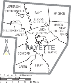
Geography
According to the U.S. Census Bureau, the county has a total area of 407 square miles (1,050km2), of which 406 square miles (1,050km2) is land and 0.7 square miles (1.8km2) (0.2%) is water.[9]
Fayette County, Ohio – Racial and ethnic composition Note: the US Census treats Hispanic/Latino as an ethnic category. This table excludes Latinos from the racial categories and assigns them to a separate category. Hispanics/Latinos may be of any race.
As of the 2010 United States census, there were 29,030people, 11,436households, and 7,834families living in the county.[24] The population density was 71.4 inhabitants per square mile (27.6/km2). There were 12,693 housing units at an average density of 31.2 unitsper square mile (12.0 units/km2).[25] The racial makeup of the county was 94.6% white, 2.0% black or African American, 0.5% Asian, 0.2% American Indian, 0.8% from other races, and 1.7% from two or more races. Those of Hispanic or Latino origin made up 1.8% of the population.[24] In terms of ancestry, 21.9% were German, 15.4% were American, 10.6% were Irish, and 9.7% were English.[26]
Of the 11,436households, 33.4% had children under the age of 18 living with them, 49.0% were married couples living together, 13.5% had a female householder with no husband present, 31.5% were non-families, and 25.8% of all households were made up of individuals. The average household size was 2.49 and the average family size was 2.95. The median age was 39.4 years.[24]
The median income for a household in the county was $39,599 and the median income for a family was $48,424. Males had a median income of $39,078 versus $31,434 for females. The per capita income for the county was $20,525. About 12.9% of families and 17.4% of the population were below the poverty line, including 22.6% of those under age 18 and 9.6% of those age 65 or over.[27]
2000 census
As of the census[28] of 2010, there were 29,030 people, 11,436 households, and 7,834 families living in the county. The population density was 71.4 inhabitants per square mile (27.6/km2). There were 12,693 housing units at an average density of 31.2 unitsper square mile (12.0 units/km2). The racial makeup of the county was 94.63% White, 2.02% Black or African American, 0.23% Native American, 0.54% Asian, 0.03% Pacific Islander, 0.80% from other races, and 1.74% from two or more races. 1.79% of the population were Hispanic or Latino of any race.
There were 11,436 households, out of which 32.53% had children under the age of 18 living with them, 49.05% were married couples living together, 13.50% had a female householder with no husband present, and 31.50% were non-families. 25.80% of all households were made up of individuals, and 10.34% had someone living alone who was 65 years of age or older. The average household size was 2.49 and the average family size was 2.95.
In the county, the population was spread out, with 24.67% under the age of 18, 7.88% from 18 to 24, 24.89% from 25 to 44, 27.59% from 45 to 64, and 14.97% who were 65 years of age or older. The median age was 39.4 years. For every 100 females there were 96.69 males. For every 100 females age 18 and over, there were 93.56 males.
As of 2013[update], the median income for a household in the county was $37,619, and the median income for a family was $45,108. Males had a median income of $30,516 versus $20,223 for females. The per capita income for the county was $20,603. About 16.1% of families and 20.1% of the population were below the poverty line, including 27.4% of those under age 18 and 9.1% of those age 65 or over.
Politics
Fayette County is a stronghold of the Republican party in presidential elections; it has voted Democratic only four times since 1856.
United States presidential election results for Fayette County, Ohio[29]
Fayette County has a 3-member Board of County Commissioners that oversee the various County departments, similar to all but 2 of the 88 Ohio counties. As of 2025, Fayette County's elected commissioners are Tony Anderson, Donnie Fleak, and Jim Garland.[31]
This page is based on this Wikipedia article Text is available under the CC BY-SA 4.0 license; additional terms may apply. Images, videos and audio are available under their respective licenses.