The town was originally founded as Flemingsburgh (or Flemingsburg)[4] on September 2, 1818, and was named for John Fleming, son of Captain Fleming of Berkeley County, Virginia, who settled in the area in 1802.[5] The name was later changed to New Holland between 1818 and 1827. The village was named after Holland, the native land of a share of the first settlers.[6]
History
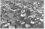
New Holland, Ohio, original 58 lots, streets, and alleys.
In 1818 the original settler's native of Pennsylvania Dutch, Hollanders, and Germans[4] settled on "Four Corners," a tract of land in the Virginia Military District, granted to Wilkins Ogden in 1802. This tact was so called because it was, in a wilderness, the intersection of a stagecoach line running east and west, and an Indian foot trail going from north to south. This crossing is today the Main and Front Street intersection.
The settlement soon outgrew its descriptive name and was then called Flemingsburgh, for John Fleming, son of Captain Fleming of Berkeley County, Virginia, who settled in New Holland in 1802. The name remained until about 1825 when the people were thinking about having a Post Office.[5] The settlers being of Dutch descent, renamed their settlement New Holland,[6] the name it remains today.
Most of the houses were log cabins build in a small cluster. There were few business places for trading at that time.
The state chartered New Holland as a village in 1834.
One of the most dramatic events in New Holland's history came after the Civil War when a portion of General Sherman'sUnion Army marched through the covered bridge on Zanesville Cincinnati Trace [ U.S. Route 22] and through New Holland. This covered bridge, which spanned over North Fork of Paint Creek on U.S. Route 22, was built in 1840, stood until 1943. Some have claimed that the old, covered bridge is now preserved in the Henry Ford Museum at Dearborn, Michigan. While Henry Ford did express admiration for the bridge, its remnants were used as scrap wood. [7]
Train Wreck
September 18, 1899, New Holland, Ohio Train Wreck
Much excitement was created on the evening of September 18, 1899, at 8 p.m., when two trains collided head on in the middle of town, at the railroad crossing located on North Main Street.
Eastbound Engine 813 had been traveling at a high rate of speed and unbeknownst to its engineer, Charles Ditto, the train's caboose and a few cars had become uncoupled at Kingsfred (located just west of Johnson's Crossing in Union Township, Fayette County). As Engine 813 approached the village of New Holland Mr. Ditto spotted the oncoming westbound Engine 801. Setting off the train's whistle, beginning about 1/2 mile outside of New Holland, Ditto attempted to signal to the brakeman to slow down for a stop, still unaware that the caboose, where the brakeman was located, had become unattached. Realizing what had happened, Ditto quickly put his train into reverse, but it was too late to avoid a collision with the other oncoming train. The engineer of Engine 801, Joe Todhunter, by this time had noticed the approaching Engine 813. In an attempt to save his train and a large amount of freight being carried by the train, uncoupled his engine and three cars, sending them on to meet the approaching train. Eyewitness accounts claimed that the impact of the two trains was so forceful that it could be heard for several miles around. Both engines raised high into the air upon impact and crashed to the ground. Engine 801, a newer engine, suffered heavy damage, with one of its cars being completely demolished. Engine 813 meanwhile was completely destroyed, its tender being overthrown and seven of its cars were demolished, with most of them being thrown across the tracks. The impact had forced one of the cars over another after its wheels were sheared off. Another box car was broken into pieces, with about half of it being thrown and crashing into the back of the Gooley Brother's Implement Store. Fortunately, no injuries occurred as a result of the crash. Both engineers and firemen had jumped to safety just moments before the collision took place. Losses from the crash were estimated at $10,000 [roughly $373,891.67 today[8]], and took workmen from about 10 p.m. that evening until the next morning to clean up the wreckage and debris.[9]
Village Government
First records of government date back to 1802. This was an abstract deed which listed the Mayor of Four Corners as John McDonald. The next date in the abstract which lists the mayor's name is March 14, 1837, and he was Francis Wilson. Also, Reverend Wilson is connected with the date of November 18, 1835, as mayor.
The first completed records of city government date back to April 6, 1869, when the first council chamber was organized. W.W. Blanedin was the mayor and council members were G.W. Gooley, S.R. Collier, J.M. Turner, and Henry Judy. S.S. McCallister was the recorder and J.D. Miller, by appointment, was the Marshall. Council met at McCafferty's hall on Saturday evening at seven o'clock.
Many records have been destroyed, misplaced, or are unavailable so that a complete list of mayors is not available. This is as complete as could be gathered: [10]
On July 23, 2018, New Holland Police Sergeant Brad Mick was fired, after filing charges against his Mayor, Police Chief, and Former Police Chief. Mick charged New Holland Interim Police Chief David Conrad with forgery, Mayor Butch Betzko with complicity to forgery, and former Chief Jason Lawless with dereliction of duty and telecommunications harassment. In a statement, the attorney representing the Village said Mick "abused his position," and was pursuing a "personal agenda with these baseless charges." The village also accused him of violating "the established chain of command" and conducting "an improper search and destruction of Village property." Mick released a statement saying: "My termination does not undo the criminal acts by others, and it will not erase evidence or dismiss the charges. While it is disheartening and a violation of the law to be retaliated against and terminated for obeying the oath of office, it does not stop here."
The charges were later dropped, and Jason Lawless was appointed Police Chief again. [13]
As of the census[16] of 2010, there were 801 people, 308 households, and 212 families living in the village. The population density was 426.1 inhabitants per square mile (164.5/km2). There were 363 housing units at an average density of 193.1 per square mile (74.6/km2). The racial makeup of the village was 97.6% White, 0.2% African American, 0.4% Native American, 0.2% Asian, 1.0% from other races, and 0.5% from two or more races. Hispanic or Latino people of any race were 1.0% of the population.
There were 308 households, of which 33.8% had children under the age of 18 living with them, 51.3% were married couples living together, 9.4% had a female householder with no husband present, 8.1% had a male householder with no wife present, and 31.2% were non-families. 22.4% of all households were made up of individuals, and 11.4% had someone living alone who was 65 years of age or older. The average household size was 2.60 and the average family size was 3.06.
The median age in the village was 41.2 years. 22.7% of residents were under the age of 18; 8.3% were between the ages of 18 and 24; 24.3% were from 25 to 44; 30% were from 45 to 64; and 14.5% were 65 years of age or older. The gender makeup of the village was 50.4% male and 49.6% female.
2000 census
As of the census[3] of 2000, there were 785 people, 313 households, and 220 families living in the village. The population density was 420.1 inhabitants per square mile (162.2/km2). There were 331 housing units at an average density of 177.1 per square mile (68.4/km2). The racial makeup of the village was 97.58% White, 0.38% African American, 0.38% Native American, and 1.66% from two or more races. Hispanic or Latino people of any race were 0.25% of the population.
There were 313 households, out of which 29.7% had children under the age of 18 living with them, 56.2% were married couples living together, 10.2% had a female householder with no husband present, and 29.4% were non-families. 25.6% of all households were made up of individuals, and 16.0% had someone living alone who was 65 years of age or older. The average household size was 2.51 and the average family size was 3.00.
In the village, the population was spread out, with 24.5% under the age of 18, 8.2% from 18 to 24, 27.9% from 25 to 44, 23.4% from 45 to 64, and 16.1% who were 65 years of age or older. The median age was 37 years. For every 100 females there were 94.8 males. For every 100 females age 18 and over, there were 90.7 males.
The median income for a household in the village was $32,188, and the median income for a family was $36,696. Males had a median income of $30,625 versus $24,191 for females. The per capita income for the village was $15,613. About 4.4% of families and 7.9% of the population were below the poverty line, including 5.5% of those under age 18 and 14.7% of those age 65 or over.
Children residing in New Holland, Ohio, attend Miami Trace Local School District. However, the town historically held its own schooling. From its founding in 1887 until the last class graduated on May 27, 1959, New Holland High School served the community.
Media
Newspapers
The New Holland Review was published from 1877-1879.
New Holland Leader Publisher Percy May
The New Holland Leader was the community newspaper for 93 years. In 1887, it was established as Plain Talk. The name New Holland leader wasn't used until 1900. The Leader was a weekly newspaper, published each Thursday. The paper contained the news and events of the town. Births, marriages, deaths, the social happenings, the coming and going of the people, and notes from the schools and churches were just some other items that could be found in the Leader.
E.B. Lewis was the first publisher of the newspaper. other publishers throughout the years included:
Years
Name
1905-1921
Percy May
1921-1947
Wendell Turner
1947
Earl Hinkle
1947-1965
Lawrence Hunter
1965-1972
Charles Mallory
1972-1981
Greenfield Times
The Leader was printed for years in the back of the old post office located at 105 N. Main St. The Leader office was then moved across the street in March 1965. This remained the office until Charles Mallory sold the paper to the Greenfield Times. In January 1973, the Leader office was moved to 212 W. Front St. in the home of Mrs. Pat Funk. Mrs. Funk was the correspondent for the paper. The New Holland Leader ceased publication on January 1, 1981.
This page is based on this Wikipedia article Text is available under the CC BY-SA 4.0 license; additional terms may apply. Images, videos and audio are available under their respective licenses.