Commercial Point, Ohio

Last updated

Commercial Point, Ohio
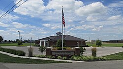
CommercialPointOH5.JPG
Commercial Point municipal building
OHMap-doton-Commercial Point.png
Location of Commercial Point, Ohio
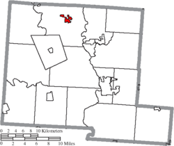
Map of Pickaway County Ohio Highlighting Commercial Point Village.png
Location of Commercial Point in Pickaway County
Coordinates: 39°47′12″N83°01′32″W / 39.78667°N 83.02556°W / 39.78667; -83.02556
Country United States
State Ohio
County Pickaway
Township Scioto
Area
[1]
  Total3.74 sq mi (9.70 km2)
  Land3.74 sq mi (9.68 km2)
  Water0.01 sq mi (0.02 km2)
Elevation
[2]
705 ft (215 m)
Population
 (2020)
  Total3,078
  Estimate 
(2023) [3]
3,215
  Density823.21/sq mi (317.81/km2)
Time zone UTC-5 (Eastern (EST))
  Summer (DST) UTC-4 (EDT)
ZIP code
43116
Area code 614
FIPS code 39-18070 [4]
GNIS feature ID2398608 [2]

Commercial Point is a village in Pickaway County, Ohio, United States. The population was 3,078 at the 2020 census. It is one of the fastest-growing villages in central Ohio. [5] It is a suburb of Columbus.

Contents

History

Wiley H. Beckett came from eastern Virginia in 1829 and settled on a 238-acre tract west of the present Commercial Point. In 1841 he laid out a community called Genoa. [6] James H. Burnley, also from Virginia, arrived in the area in 1832 and laid out a similar community east of Genoa called Rome. As the two towns grew larger, Rome became the western half, and Genoa the eastern half, of a new single town. When Genoa was incorporated in 1851, Rome was merged into the new village. The first store was established in 1844 by Wiley H. Beckett, and the post office was originally named Beckett's Store. The name of the village was changed in 1872 to Commercial Point. [7]

Geography

According to the United States Census Bureau, the village has a total area of 1.13 square miles (2.93 km2), all of it land. [8]

Demographics

Historical population
CensusPop.Note
1870 154
1880 1699.7%
1890 26556.8%
1900 245−7.5%
1910 234−4.5%
1920 220−6.0%
1930 211−4.1%
1940 207−1.9%
1950 23815.0%
1960 30829.4%
1970 3203.9%
1980 316−1.2%
1990 40528.2%
2000 77691.6%
2010 1,582103.9%
2020 3,07894.6%
2023 (est.)3,215 [3] 4.5%
U.S. Decennial Census [9]

2020 census

As of the census [10] of 2020, there were 3,078 people, 963 households, and 897 families residing in the village. The racial makeup of the village was 87.5% White, 2.7% African American,, 1.6% Asian, 0.2% Native American 1.3% from other races, and 6.7% from two or more races. Hispanic or Latino people of any race were 2.0% of the population.

The median household income in the village was $102,689, and the median income for a family was $107,000. Median income for married-couples families was $115,679. Males had a median income of $71,691 versus $64,595 for females. The per capita income for the village was $43,964. About 5.6% of the population were below the poverty line. Home ownership rate in the village was 93.8%.

There were 963 households, of which 34.0% had children under the age of 18 living with them, 64.5% were married couples living together, 10.9% had a female householder with no husband present, 4.6% had a male householder with no wife present, and 18.5% were non-families. 14.0% of all households were made up of individuals, and 4.2% had someone living alone who was 65 years of age or older. The average family size was 3.8.

The median age in the village was 33.0 years. 37.3% of residents were under the age of 18; 5.2% were between the ages of 18 and 24; 24% were from 25 to 44; 25.2% were from 45 to 64; and 6.9% were 65 years of age or older. The gender makeup of the village was 49.0% male and 51.0% female.

2010 census

As of the census [11] of 2010, there were 1,582 people, 507 households, and 413 families residing in the village. The population density was 1,400.0 inhabitants per square mile (540.5/km2). There were 547 housing units at an average density of 484.1 per square mile (186.9/km2). The racial makeup of the village was 94.4% White, 1.3% African American, 0.3% Native American, 1.3% Asian, 1.0% from other races, and 1.8% from two or more races. Hispanic or Latino people of any race were 2.0% of the population.

There were 507 households, of which 53.1% had children under the age of 18 living with them, 67.5% were married couples living together, 9.7% had a female householder with no husband present, 4.3% had a male householder with no wife present, and 18.5% were non-families. 14.0% of all households were made up of individuals, and 4.2% had someone living alone who was 65 years of age or older. The average household size was 3.12 and the average family size was 3.43.

The median age in the village was 32.1 years. 34.8% of residents were under the age of 18; 6.1% were between the ages of 18 and 24; 32.7% were from 25 to 44; 19.9% were from 45 to 64; and 6.4% were 65 years of age or older. The gender makeup of the village was 48.0% male and 52.0% female.

2000 census

As of the census [4] of 2000, there were 776 people, 277 households, and 222 families residing in the village. The population density was 712.5 inhabitants per square mile (275.1/km2). There were 288 housing units at an average density of 264.4 per square mile (102.1/km2). The racial makeup of the village was 98.07% White, 0.13% African American, 0.13% Asian, and 1.68% from two or more races. Hispanic or Latino people of any race were 0.52% of the population.

There were 277 households, out of which 44.0% had children under the age of 18 living with them, 66.8% were married couples living together, 9.4% had a female householder with no husband present, and 19.5% were non-families. 14.8% of all households were made up of individuals, and 6.5% had someone living alone who was 65 years of age or older. The average household size was 2.80 and the average family size was 3.13.

In the village, the population was spread out, with 30.5% under the age of 18, 6.8% from 18 to 24, 35.3% from 25 to 44, 19.7% from 45 to 64, and 7.6% who were 65 years of age or older. The median age was 34 years. For every 100 females there were 95.5 males. For every 100 females age 18 and over, there were 93.9 males.

The median income for a household in the village was $55,563, and the median income for a family was $56,806. Males had a median income of $33,571 versus $26,625 for females. The per capita income for the village was $21,964. About 6.7% of families and 9.0% of the population were below the poverty line, including 16.2% of those under age 18 and 29.8% of those age 65 or over.

Education

Commercial Point is served by the Teays Valley Local School District. Schools located here include the highly rated Scioto Elementary School and Teays Valley West Middle School.

Notable residents

Related Research Articles

<span class="mw-page-title-main">Sycamore Hills, Missouri</span> Village in Missouri, United States

Sycamore Hills is a village in St. Louis County, Missouri, United States. The population is 560 at the 2020 census.

<span class="mw-page-title-main">Westwood, Missouri</span> Village in Missouri, United States

Westwood is a village in west St. Louis County, Missouri, United States. The population was 316 at the 2020 census.

<span class="mw-page-title-main">Cortland, Nebraska</span> Village in Nebraska, United States

Cortland is a village in Gage County, Nebraska, United States. The population was 504 at the 2020 census.

<span class="mw-page-title-main">Virginia, Nebraska</span> Village in Nebraska, United States

Virginia is a village in Gage County, Nebraska, United States. The population was 74 at the 2020 census.

<span class="mw-page-title-main">Genoa, Nebraska</span> City in Nance County, Nebraska, United States

Genoa(pron. je NO uh) is a city in Nance County, Nebraska, United States. The population was 894 at the 2020 census. The city was founded by Mormons in 1857. In the fall of 1859, the Mormon Colony was forced to abandon Genoa when the town and surrounding area were incorporated into the newly created Pawnee Reservation. The Pawnee Indian Agency utilized the structures vacated by the Mormons.

<span class="mw-page-title-main">Lockbourne, Ohio</span> Village in Ohio, United States

Lockbourne is a village in Franklin County and Pickaway County, Ohio, United States. The population was 236 at the 2020 census. Lockbourne is located near Rickenbacker International Airport, and had initially provided its original name of Lockbourne Air Force Base.

<span class="mw-page-title-main">Addyston, Ohio</span> Village in Ohio, United States

Addyston is a village in Miami Township, Hamilton County, Ohio, United States. Located along the Ohio River, it is a western suburb of the neighboring city of Cincinnati. The population was 927 at the 2020 census.

<span class="mw-page-title-main">Cleves, Ohio</span> Village in Ohio, United States

Cleves is a village in Miami Township, Hamilton County, Ohio, United States. Located along the Ohio River, it is a western suburb of Cincinnati. The population was 3,414 at the 2020 census.

<span class="mw-page-title-main">Elmwood Place, Ohio</span> Village in Hamilton County, Ohio, United States

Elmwood Place is a village in Hamilton County, Ohio, United States. The population was 2,087 at the 2020 census. Except for a small portion which touches neighboring St. Bernard, Elmwood Place is nearly surrounded by the city of Cincinnati.

<span class="mw-page-title-main">Woodlawn, Ohio</span> Village in Ohio, United States

Woodlawn is a village in Hamilton County, Ohio, United States. The population was 3,916 at the 2020 census.

<span class="mw-page-title-main">Jenera, Ohio</span> Village in Ohio, United States

Jenera is a village in Hancock County, Ohio, United States. The population was 257 at the 2020 census. It is surrounded by Van Buren Township and is part of the Cory-Rawson Local School District.

<span class="mw-page-title-main">Fultonham, Ohio</span> Village in Ohio, United States

Fultonham is a village in Muskingum County, Ohio, United States. The population was 115 at the 2020 census. It is part of the Zanesville micropolitan area. Fultonham was named for Robert Fulton, inventor of the first commercially successful steamboat.

<span class="mw-page-title-main">Clay Center, Ohio</span> Village in Ohio, United States

Clay Center is a village in Ottawa County, Ohio, United States. The population was 262 at the 2020 census.

<span class="mw-page-title-main">Genoa, Ohio</span> Village in Ohio, United States

Genoa is a village in Ottawa County, Ohio, United States. The population was 2,232 at the 2020 census. Originally settled as Stony Ridge, it took its present name in 1856 and was incorporated as a village on September 7, 1868.

<span class="mw-page-title-main">Meyers Lake, Ohio</span> Village in Ohio, United States

Meyers Lake is a village in central Stark County, Ohio, United States. The population was 724 at the 2020 census. It is part of the Canton–Massillon metropolitan area.

<span class="mw-page-title-main">Wilson, Ohio</span> Village in Ohio, United States

Wilson is a village in Belmont and Monroe counties in the U.S. state of Ohio. The population was 129 at the 2020 census. It is part of the Wheeling metropolitan area.

<span class="mw-page-title-main">Verona, Ohio</span> Village in Ohio, United States

Verona is a village in Montgomery and Preble counties in the U.S. state of Ohio. The population was 403 at the 2020 census. It is part of the Dayton Metropolitan Statistical Area.

<span class="mw-page-title-main">Genoa City, Wisconsin</span> Village in Wisconsin, United States

Genoa City is a village located in Kenosha and Walworth counties in the U.S. state of Wisconsin, 43 mi (69 km) south-southwest of Milwaukee, located on the Illinois–Wisconsin border. The population was 2,982 at the 2020 census. It was named after Genoa, New York, which was named after Genoa in Italy.

<span class="mw-page-title-main">Bangor, Wisconsin</span> Village in Wisconsin, United States

Bangor is a village in La Crosse County, Wisconsin, United States, along the La Crosse River. It is part of the La Crosse-Onalaska, WI-MN Metropolitan Statistical Area. The population was 1,437 as of the 2020 Census. The village is located partially within the Town of Bangor.

<span class="mw-page-title-main">Genoa, Wisconsin</span> Village in Wisconsin, United States

Genoa is a village in Vernon County, Wisconsin, United States. The population was 232 at the 2020 census. The village is within the Town of Genoa.

References

  1. "ArcGIS REST Services Directory". United States Census Bureau. Retrieved September 20, 2022.
  2. 1 2 U.S. Geological Survey Geographic Names Information System: Commercial Point, Ohio
  3. 1 2 "Annual Estimates of the Resident Population for Incorporated Places in Ohio: April 1, 2020 to July 1, 2023". United States Census Bureau. Retrieved June 13, 2024.
  4. 1 2 "U.S. Census website". United States Census Bureau . Retrieved January 31, 2008.
  5. "Commercial Point outgrows Circleville". Circleville Online. July 9, 2019. Retrieved July 9, 2019.
  6. Overman, William Daniel (1958). Ohio Town Names. Akron, OH: Atlantic Press. p. 32.
  7. http://www.rootsweb.ancestry.com/~ohpickaw/histories/history_of_pickaway_county.htm [ user-generated source ]
  8. "US Gazetteer files 2010". United States Census Bureau. Archived from the original on July 2, 2012. Retrieved January 6, 2013.
  9. "Census of Population and Housing". Census.gov. Retrieved June 4, 2015.
  10. "U.S. Census website". United States Census Bureau . Retrieved June 6, 2023.
  11. "U.S. Census website". United States Census Bureau . Retrieved January 6, 2013.