Tarlton, Ohio

Last updated

Tarlton, Ohio
TarltonOhio2.JPG
Looking east on Main Street in Tarlton
OHMap-doton-Tarlton.png
Location of Tarlton, Ohio
Map of Pickaway County Ohio Highlighting Tarlton Village.png
Location of Tarlton in Pickaway County
Coordinates: 39°33′15″N82°46′41″W / 39.55417°N 82.77806°W / 39.55417; -82.77806
Country United States
State Ohio
Counties Fairfield, Pickaway
Area
[1]
  Total
0.38 sq mi (0.99 km2)
  Land0.38 sq mi (0.99 km2)
  Water0.00 sq mi (0.00 km2)
Elevation
[2]
883 ft (269 m)
Population
 (2020)
  Total
254
  Density661.46/sq mi (255.47/km2)
Time zone UTC-5 (Eastern (EST))
  Summer (DST) UTC-4 (EDT)
ZIP code
43156
Area code 740
FIPS code 39-76148 [3]
GNIS feature ID2399954 [2]
Website villageoftarlton.com

Tarlton is a village in Fairfield and Pickaway counties in the U.S. state of Ohio. The population was 254 at the 2020 census.

Contents

History

Tarlton was originally called Newellstown, and under the latter name was laid out in 1801. [4]

The Cross Mound is nearby, which was built by the pre-Columbian Mound Builders.

Geography

According to the United States Census Bureau, the village has a total area of 0.42 square miles (1.09 km2), all land. [5]

Tarlton is 30 miles southeast of Columbus.

Demographics

Historical population
CensusPop.Note
1870 407
1880 4254.4%
1890 4485.4%
1900 388−13.4%
1910 302−22.2%
1920 270−10.6%
1930 2783.0%
1940 274−1.4%
1950 37135.4%
1960 3771.6%
1970 4129.3%
1980 394−4.4%
1990 315−20.1%
2000 298−5.4%
2010 282−5.4%
2020 254−9.9%
U.S. Decennial Census [6]

2010 census

As of the census [7] of 2010, there were 282 people, 100 households, and 77 families living in the village. The population density was 671.4 inhabitants per square mile (259.2/km2). There were 115 housing units at an average density of 273.8 per square mile (105.7/km2). The racial makeup of the village was 98.9% White, 0.7% African American, and 0.4% from two or more races. Hispanic or Latino people of any race were 2.8% of the population.

There were 100 households, of which 41.0% had children under the age of 18 living with them, 58.0% were married couples living together, 14.0% had a female householder with no husband present, 5.0% had a male householder with no wife present, and 23.0% were non-families. 18.0% of all households were made up of individuals, and 10% had someone living alone who was 65 years of age or older. The average household size was 2.82 and the average family size was 3.23.

The median age in the village was 39.2 years. 27% of residents were under the age of 18; 8.4% were between the ages of 18 and 24; 22.3% were from 25 to 44; 31.9% were from 45 to 64; and 10.3% were 65 years of age or older. The gender makeup of the village was 47.5% male and 52.5% female.

2000 census

As of the census [3] of 2000, there were 298 people, 102 households, and 75 families living in the village. The population density was 710.2 inhabitants per square mile (274.2/km2). There were 120 housing units at an average density of 286.0 per square mile (110.4/km2). The racial makeup of the village was 100.00% White.

There were 102 households, out of which 38.2% had children under the age of 18 living with them, 56.9% were married couples living together, 8.8% had a female householder with no husband present, and 25.5% were non-families. 23.5% of all households were made up of individuals, and 13.7% had someone living alone who was 65 years of age or older. The average household size was 2.92 and the average family size was 3.39.

In the village, the population was spread out, with 31.2% under the age of 18, 7.4% from 18 to 24, 30.5% from 25 to 44, 19.8% from 45 to 64, and 11.1% who were 65 years of age or older. The median age was 36 years. For every 100 females there were 101.4 males. For every 100 females age 18 and over, there were 107.1 males.

The median income for a household in the village was $31,875, and the median income for a family was $43,125. Males had a median income of $30,938 versus $25,625 for females. The per capita income for the village was $13,379. About 9.0% of families and 6.0% of the population were below the poverty line, including 1.1% of those under the age of eighteen and 22.5% of those 65 or over.

Notable person

Related Research Articles

<span class="mw-page-title-main">Warsaw, Ohio</span> Village in Ohio, United States

Warsaw is a village in Coshocton County, Ohio, United States, along the Walhonding River. The population was 624 at the 2020 census.

<span class="mw-page-title-main">Palestine, Ohio</span> Village in Ohio, United States

Palestine is a village in Darke County, Ohio, United States. The population was 180 at the 2020 census.

<span class="mw-page-title-main">Addyston, Ohio</span> Village in Ohio, United States

Addyston is a village in Miami Township, Hamilton County, Ohio, United States. Located along the Ohio River, it is a western suburb of the neighboring city of Cincinnati. The population was 927 at the 2020 census.

<span class="mw-page-title-main">Evendale, Ohio</span> Village in Ohio, United States

Evendale is a village in Hamilton County, Ohio, United States, within the Cincinnati metropolitan area. The population was 2,669 at the 2020 census.

<span class="mw-page-title-main">North Bend, Ohio</span> Village in Ohio, United States

North Bend is a village in Miami Township, Hamilton County, Ohio, United States, along the Ohio River. It is a part of the Greater Cincinnati area. The population was 835 at the 2020 census.

<span class="mw-page-title-main">Mowrystown, Ohio</span> Village in Ohio, United States

Mowrystown is a village in Highland County, Ohio, United States. The population was 385 at the 2020 census.

<span class="mw-page-title-main">Brinkhaven, Ohio</span> Village in Ohio, United States

Brinkhaven is a village in Union Township, Knox County, Ohio, United States. The population was 114 at the 2020 census.

<span class="mw-page-title-main">Hartford, Ohio</span> Village in Ohio, United States

Hartford is a village in the township of the same name in Licking County, Ohio, United States. The population was 404 at the 2020 census.

<span class="mw-page-title-main">St. Louisville, Ohio</span> Village in Ohio, United States

St. Louisville or Saint Louisville is a village in Licking County, Ohio, United States, along the North Fork of the Licking River. The population was 352 at the 2020 census.

<span class="mw-page-title-main">Berkey, Ohio</span> Village in the United States

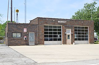
Berkey is a village in Lucas County, Ohio, United States. The population was 275 at the 2020 census.

<span class="mw-page-title-main">Adamsville, Ohio</span> Village in Ohio, United States

Adamsville is a village in Muskingum County, Ohio, United States. The population was 140 at the 2020 census. It is part of the Zanesville micropolitan area.

<span class="mw-page-title-main">Darbyville, Ohio</span> Village in Ohio, United States

Darbyville is a village in Pickaway County, Ohio, United States. The population was 186 at the 2020 census.

<span class="mw-page-title-main">Port Jefferson, Ohio</span> Village in Ohio, United States

Port Jefferson is a village in Salem Township, Shelby County, Ohio, United States. The population was 308 at the 2020 census.

<span class="mw-page-title-main">Limaville, Ohio</span> Census-designated place in Ohio, United States

Limaville is a census-designated place (CDP) and former village in Stark County, Ohio, United States. The population was 151 at the 2020 census. It is part of the Canton–Massillon Metropolitan Statistical Area.

<span class="mw-page-title-main">Boston Heights, Ohio</span> Village in Ohio, United States

Boston Heights is a village in northern Summit County, Ohio, United States. The population was 1,402 at the 2020 census. It is part of the Akron metropolitan area. Boston Heights is home to the headquarters of Arhaus, a major home furnishings retailer.

<span class="mw-page-title-main">Macksburg, Ohio</span> Village in Ohio, United States

Macksburg is a village in Washington County, Ohio, United States, along the West Fork of Duck Creek. The population was 120 at the 2020 census. The village is about 28 miles (45 km) south of Cambridge, Ohio.

<span class="mw-page-title-main">Wilson, Ohio</span> Village in Ohio, United States

Wilson is a village in Belmont and Monroe counties in the U.S. state of Ohio. The population was 129 at the 2020 census. It is part of the Wheeling metropolitan area.

<span class="mw-page-title-main">Burkettsville, Ohio</span> Village in Ohio, United States

Burkettsville is a village in Darke and Mercer counties in the U.S. state of Ohio. The population was 272 at the 2020 census.

<span class="mw-page-title-main">Gratiot, Ohio</span> Village in Ohio, United States

Gratiot is a village in Licking and Muskingum counties in the U.S. state of Ohio. The population was 215 at the 2020 census.

<span class="mw-page-title-main">Verona, Ohio</span> Village in Ohio, United States

Verona is a village in Montgomery and Preble counties in the U.S. state of Ohio. The population was 403 at the 2020 census. It is part of the Dayton Metropolitan Statistical Area.

References

  1. "ArcGIS REST Services Directory". United States Census Bureau. Retrieved September 20, 2022.
  2. 1 2 U.S. Geological Survey Geographic Names Information System: Tarlton, Ohio
  3. 1 2 "U.S. Census website". United States Census Bureau . Retrieved January 31, 2008.
  4. Overman, William Daniel (1958). Ohio Town Names. Akron, OH: Atlantic Press. p. 132.
  5. "US Gazetteer files 2010". United States Census Bureau. Archived from the original on January 25, 2012. Retrieved January 6, 2013.
  6. "Census of Population and Housing". Census.gov. Retrieved June 4, 2015.
  7. "U.S. Census website". United States Census Bureau . Retrieved January 6, 2013.