Tarlton Cross Mound | |
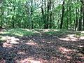
 Tarlton Cross Mound from the west | |
  | |
| Location | Cross Mound Park, northwest of Tarlton [1] |
|---|---|
| Nearest city | Tarlton, Ohio |
| Coordinates | 39°33′44″N82°47′7″W / 39.56222°N 82.78528°W |
| Area | Less than 1 acre (0.40 ha) |
| NRHP reference No. | 70000489 [2] |
| Added to NRHP | November 10, 1970 |
Cross Mound (also called the Tarlton Cross Mound) is an earthwork located near Tarlton, Ohio in the United States. The culture who built it and the time it was built remains unknown. It is listed on the National Register of Historic Places. [3] A 21st-century archaeologists described it as "one of the many enigmatic effigy mounds in Southern Ohio." [4]