West Rushville, Ohio

Last updated

West Rushville, Ohio
Joseph Ijams House.jpg
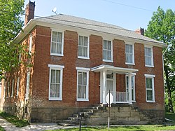
Joseph Ijams House, built 1810
OHMap-doton-West Rushville.png
Location of West Rushville, Ohio
Map of Fairfield County Ohio Highlighting West Rushville Village.png
Location of West Rushville in Fairfield County
Coordinates: 39°45′50″N82°26′54″W / 39.76389°N 82.44833°W / 39.76389; -82.44833
Country United States
State Ohio
County Fairfield
Area
[1]
  Total0.07 sq mi (0.17 km2)
  Land0.07 sq mi (0.17 km2)
  Water0.00 sq mi (0.00 km2)
Elevation
[2]
1,017 ft (310 m)
Population
 (2020)
  Total166
  Density2,553.85/sq mi (988.51/km2)
Time zone UTC-5 (Eastern (EST))
  Summer (DST) UTC-4 (EDT)
ZIP code
43150
Area code 740
FIPS code 39-84182
GNIS feature ID2400142 [2]

West Rushville is a village in Fairfield County, Ohio, United States. The population was 166 at the 2020 census.

Contents

History

A post office called West Rushville was established in 1842, and remained in operation until 1996. [3] The village was named for its location on the west bank of Little Rush Creek, which separates the villages of Rushville and West Rushville. [4]

Geography

According to the United States Census Bureau, the village has a total area of 0.07 square miles (0.18 km2), all land. [5]

Demographics

Historical population
CensusPop.Note
1870 185
1880 21214.6%
1890 195−8.0%
1900 161−17.4%
1910 147−8.7%
1920 142−3.4%
1930 138−2.8%
1940 1498.0%
1950 1522.0%
1960 17414.5%
1970 1898.6%
1980 159−15.9%
1990 134−15.7%
2000 132−1.5%
2010 1341.5%
2020 16623.9%
U.S. Decennial Census [6]

2010 census

As of the census [7] of 2010, there were 134 people, 51 households, and 38 families living in the village. The population density was 1,914.3 inhabitants per square mile (739.1/km2). There were 62 housing units at an average density of 885.7 per square mile (342.0/km2). The racial makeup of the village was 97.0% White and 3.0% from two or more races. Hispanic or Latino of any race were 0.7% of the population.

There were 51 households, of which 39.2% had children under the age of 18 living with them, 52.9% were married couples living together, 11.8% had a female householder with no husband present, 9.8% had a male householder with no wife present, and 25.5% were non-families. 21.6% of all households were made up of individuals, and 11.8% had someone living alone who was 65 years of age or older. The average household size was 2.63 and the average family size was 3.00.

The median age in the village was 36 years. 29.1% of residents were under the age of 18; 8.9% were between the ages of 18 and 24; 28.4% were from 25 to 44; 24.7% were from 45 to 64; and 9% were 65 years of age or older. The gender makeup of the village was 50.7% male and 49.3% female.

2000 census

As of the census [8] of 2000, there were 132 people, 49 households, and 38 families living in the village. The population density was 2,174.2 inhabitants per square mile (839.5/km2). There were 50 housing units at an average density of 823.6 per square mile (318.0/km2). The racial makeup of the village was 99.24% White, and 0.76% from two or more races. Hispanic or Latino of any race were 3.03% of the population.

There were 49 households, out of which 49.0% had children under the age of 18 living with them, 61.2% were married couples living together, 10.2% had a female householder with no husband present, and 22.4% were non-families. 20.4% of all households were made up of individuals, and 12.2% had someone living alone who was 65 years of age or older. The average household size was 2.69 and the average family size was 3.05. In the village, the population was spread out, with 31.1% under the age of 18, 9.1% from 18 to 24, 31.8% from 25 to 44, 19.7% from 45 to 64, and 8.3% who were 65 years of age or older. The median age was 33 years. For every 100 females there were 100.0 males. For every 100 females age 18 and over, there were 97.8 males.

The median income for a household in the village was $43,125, and the median income for a family was $56,500. Males had a median income of $28,125 versus $30,000 for females. The per capita income for the village was $16,257. There were 5.0% of families and 6.2% of the population living below the poverty line, including 15.2% of under eighteens and none of those over 64.
Buildings

West Rushville is home to the Fairfield Union Local School District administrative office.

The historic Joseph Ijams House sits at the crossroads at the center of the village. Built circa 1810 it once served as a tavern on the old Zane's Trace road.

Related Research Articles

<span class="mw-page-title-main">Industry, Illinois</span> Village in Illinois, United States

Industry is a village in McDonough County, Illinois, United States. As of the 2020 census, the village population was 399, down from 478 in 2010.

<span class="mw-page-title-main">Island Falls, Maine</span> Town in the state of Maine, United States

Island Falls is a town in Aroostook County, Maine, United States. The population was 758 at the 2020 census. The primary village of Island Falls in the town is situated at a falls in the West Branch Mattawamkeag River.

<span class="mw-page-title-main">Rushville, Missouri</span> Village in Missouri, United States

Rushville is a village in western Buchanan County, Missouri, United States. The population was 225 at the 2020 census. It is part of the St. Joseph, MO–KS Metropolitan Statistical Area.

<span class="mw-page-title-main">West Line, Missouri</span> Village in Missouri, United States

West Line is a village in Cass County, Missouri. The population was 97 at the 2010 census. It is part of the Kansas City metropolitan area.

<span class="mw-page-title-main">Cedar Hill Lakes, Missouri</span> Village in Missouri, United States

Cedar Hill Lakes is a village in Jefferson County, Missouri, United States. The population was 203 at the 2020 census.

<span class="mw-page-title-main">Rushville, Nebraska</span> City in and county seat of Sheridan Count, Nebraska, United States

Rushville is a city in Sheridan County, Nebraska, United States, in the remote Sandhills Region. Its population was 890 at the 2010 census. It is the county seat of Sheridan County.

<span class="mw-page-title-main">West Union, Ohio</span> Village in Ohio, United States

West Union is a village in Adams County, Ohio, United States, about 55 miles (89 km) southeast of Cincinnati. The population was 3,004 at the 2020 census. It is the county seat of Adams County. West Union is served by West Union High School, the Adams County/Ohio Valley School District, and the West Union Public Library, a branch of the Adams County Public Library.

<span class="mw-page-title-main">Palestine, Ohio</span> Village in Ohio, United States

Palestine is a village in Darke County, Ohio, United States. The population was 180 at the 2020 census.

<span class="mw-page-title-main">Rushville, Ohio</span> Village in Ohio, United States

Rushville is a village in Fairfield County, Ohio, United States. The population was 304 at the 2020 census. Much of the village is listed on the National Register of Historic Places as the Rushville Historic District.

<span class="mw-page-title-main">Riverlea, Ohio</span> Village in Ohio, United States

Riverlea is a village in Franklin County, Ohio, United States, surrounded by Worthington on its north, south, and east sides, and bordered on the west by the Olentangy River, across which is Columbus. Riverlea was incorporated in 1939, a small community that formed on former farmland. The population was 599 at the 2020 census.

<span class="mw-page-title-main">West Mansfield, Ohio</span> Village in Ohio, United States

West Mansfield is a village located in Logan County, Ohio, United States. The population was 749 at the 2020 census.

<span class="mw-page-title-main">Rochester, Ohio</span> Village in Ohio

Rochester is a village in Lorain County, Ohio, United States, along the West Branch of the Black River. The population was 159 at the 2020 census.

<span class="mw-page-title-main">Darbyville, Ohio</span> Village in Ohio, United States

Darbyville is a village in Pickaway County, Ohio, United States. The population was 186 at the 2020 census.

<span class="mw-page-title-main">Tarlton, Ohio</span> Village in Ohio, United States

Tarlton is a village in Fairfield and Pickaway counties in the U.S. state of Ohio. The population was 254 at the 2020 census.

<span class="mw-page-title-main">Macksburg, Ohio</span> Village in Ohio, United States

Macksburg is a village in Washington County, Ohio, United States, along the West Fork of Duck Creek. The population was 120 at the 2020 census. The village is about 28 miles (45 km) south of Cambridge, Ohio.

<span class="mw-page-title-main">Harpster, Ohio</span> Village in Ohio, United States

Harpster is a village in Wyandot County, Ohio, United States. The population was 160 at the 2020 census.

<span class="mw-page-title-main">Windsor Heights, West Virginia</span> Village in West Virginia, United States

Windsor Heights is a village in Brooke County, West Virginia, United States. It is part of the Wheeling, West Virginia Metropolitan Statistical Area. The population was 423 at the 2010 census. Grace Davis was the mayor as of June, 2017.

<span class="mw-page-title-main">Clearview, West Virginia</span> Village in West Virginia, United States

Clearview is a village in Ohio County, West Virginia, United States. It is part of the Wheeling, West Virginia Metropolitan Statistical Area. The population was 565 at the 2010 census.

<span class="mw-page-title-main">Oliver, Wisconsin</span> Village in Wisconsin, United States

Oliver is a village in Douglas County, Wisconsin, United States. The population was 423 at the 2020 census.

<span class="mw-page-title-main">Verona, Ohio</span> Village in Ohio, United States

Verona is a village in Montgomery and Preble counties in the U.S. state of Ohio. The population was 403 at the 2020 census. It is part of the Dayton Metropolitan Statistical Area.

References

  1. "ArcGIS REST Services Directory". United States Census Bureau. Retrieved September 20, 2022.
  2. 1 2 U.S. Geological Survey Geographic Names Information System: West Rushville, Ohio
  3. "Post offices". Jim Forte Postal History. Retrieved June 21, 2016.
  4. Overman, William Daniel (1958). Ohio Town Names. Akron, OH: Atlantic Press. p. 143.
  5. "US Gazetteer files 2010". United States Census Bureau . Retrieved January 6, 2013.
  6. "Census of Population and Housing". Census.gov. Retrieved June 4, 2015.
  7. "U.S. Census website". United States Census Bureau . Retrieved January 6, 2013.
  8. "U.S. Census website". United States Census Bureau . Retrieved January 31, 2008.