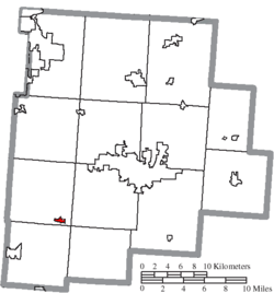
Amanda, Ohio | |
---|---|
Coordinates: 39°39′02″N82°44′46″W / 39.65056°N 82.74611°W [1] | |
Country | United States |
State | Ohio |
County | Fairfield County |
Township | Amanda Township |
Area | |
• Total | 0.32 sq mi (0.82 km2) |
• Land | 0.32 sq mi (0.82 km2) |
• Water | 0.00 sq mi (0.00 km2) |
Elevation | 935 ft (285 m) |
Population (2020) | |
• Total | 673 |
• Estimate (2023) [3] | 680 |
• Density | 2,123.03/sq mi (819.55/km2) |
Time zone | UTC-5 (Eastern (EST)) |
• Summer (DST) | UTC-4 (EDT) |
ZIP code | 43102 |
Area code | 740 |
FIPS code | 01630 [4] |
GNIS feature ID | 2397953 [1] |
Website | villageofamanda |
Amanda is a village in Fairfield County, Ohio, United States. The population was 637 at the 2020 census.
Amanda was founded around 1830, but development would not begin in earnest until 1850 when the railroad was extended to that point. [5] A post office has been in operation at Amanda since 1832. [6]
According to the United States Census Bureau, the village has a total area of 0.30 square miles (0.78 km2), all land. [7]
Census | Pop. | Note | %± |
---|---|---|---|
1850 | 181 | — | |
1880 | 375 | — | |
1890 | 469 | 25.1% | |
1910 | 484 | — | |
1920 | 531 | 9.7% | |
1930 | 557 | 4.9% | |
1940 | 561 | 0.7% | |
1950 | 587 | 4.6% | |
1960 | 732 | 24.7% | |
1970 | 788 | 7.7% | |
1980 | 720 | −8.6% | |
1990 | 729 | 1.3% | |
2000 | 707 | −3.0% | |
2010 | 737 | 4.2% | |
2020 | 673 | −8.7% | |
2023 (est.) | 680 | [3] | 1.0% |
U.S. Decennial Census [8] |
As of the census [9] of 2010, there were 737 people, 270 households, and 205 families living in the village. The population density was 2,456.7 inhabitants per square mile (948.5/km2). There were 295 housing units at an average density of 983.3 per square mile (379.7/km2). The racial makeup of the village was 96.6% White, 0.9% African American, 0.1% Pacific Islander, 0.5% from other races, and 1.8% from two or more races. Hispanic or Latino people of any race were 1.4% of the population.
There were 270 households, of which 43.3% had children under the age of 18 living with them, 56.7% were married couples living together, 11.5% had a female householder with no husband present, 7.8% had a male householder with no wife present, and 24.1% were non-families. 21.1% of all households were made up of individuals, and 8.9% had someone living alone who was 65 years of age or older. The average household size was 2.73 and the average family size was 3.10.
The median age in the village was 37 years. 30% of residents were under the age of 18; 7.5% were between the ages of 18 and 24; 26.4% were from 25 to 44; 23.6% were from 45 to 64; and 12.6% were 65 years of age or older. The gender makeup of the village was 51.6% male and 48.4% female.
As of the census [4] of 2000, there were 707 people, 256 households, and 203 families living in the village. The population density was 2,160.6 inhabitants per square mile (834.2/km2). There were 269 housing units at an average density of 822.1 per square mile (317.4/km2). The racial makeup of the village was 98.59% White, 0.28% Native American, and 1.13% from two or more races. Hispanic or Latino people of any race were 0.71% of the population.
There were 256 households, out of which 40.2% had children under the age of 18 living with them, 67.6% were married couples living together, 8.6% had a female householder with no husband present, and 20.7% were non-families. 19.1% of all households were made up of individuals, and 8.2% had someone living alone who was 65 years of age or older. The average household size was 2.76 and the average family size was 3.09.
In the village, the population was spread out, with 29.1% under the age of 18, 5.5% from 18 to 24, 33.0% from 25 to 44, 18.4% from 45 to 64, and 14.0% who were 65 years of age or older. The median age was 34 years. For every 100 females there were 90.6 males. For every 100 females age 18 and over, there were 91.2 males.
The median income for a household in the village was $40,114, and the median income for a family was $43,750. Males had a median income of $36,563 versus $21,176 for females. The per capita income for the village was $16,208. About 3.6% of families and 3.6% of the population were below the poverty line, including 2.3% of those under age 18 and 1.8% of those age 65 or over.
Public education in Amanda is administered by the Amanda Clearcreek Local Schools district. [10] Amanda has a public library, a branch of the Fairfield County District Library. [11]
Fairfield County is a county located in the U.S. state of Ohio. As of the 2020 census, the population was 158,921. Its county seat and largest city is Lancaster. Its name is a reference to the Fairfield area of the original Lancaster.
Fairfield Bay is a city in Cleburne and Van Buren counties in the northern part of the U.S. state of Arkansas. The population was 2,108 at the 2020 census. The population in its portion in Van Buren County, which accounts for the bulk of the city limits, made the city the most populous in Van Buren County as of the 2000 census, but with a slight decline in population, lost the distinction to Clinton as of 2010.
Baltimore is a village in Fairfield County, Ohio, United States. The population was 2,981 at the 2020 census.
Bremen is a village in Fairfield County, Ohio, United States. The population was 1,479 at the 2020 census.
Carroll is a village in Fairfield County, Ohio, United States. The population was 501 at the 2020 census.
Fairfield Beach is an unincorporated community and census-designated place (CDP) in Fairfield County, Ohio, United States. The population was 1,267 at the 2020 census.
Lithopolis is a village in Fairfield and Franklin counties in the U.S. state of Ohio. The population was 2,134 at the 2020 census.
Millersport is a village in Fairfield County, Ohio, United States. The population was 978 at the 2020 census. Millersport is most notable as the home of the Sweet Corn Festival, which is held in Millersport annually during the first week of September.
Pleasantville is a village in Fairfield County, Ohio, United States. The population was 934 at the 2020 census.
Stoutsville is a village in Fairfield County, Ohio, United States. The population was 579 at the 2020 census.
Sugar Grove is a village in Fairfield County, Ohio, United States. The population was 429 at the 2020 census.
Thurston is a village in Fairfield County, Ohio, United States. The population was 603 at the 2020 census.
Riverlea is a village in Franklin County, Ohio, United States, surrounded by Worthington on its north, south, and east sides, and bordered on the west by the Olentangy River, across which is Columbus. Riverlea was incorporated in 1939, a small community that formed on former farmland. The population was 599 at the 2020 census.
Highland is a village in Fairfield Township, Highland County, Ohio, United States. The population was 232 at the 2020 census.
Leesburg is a village in Highland County, Ohio, United States. The population was 1,273 at the 2020 census.
North Fairfield is a village in Huron County, Ohio, United States. The population was 465 at the 2020 census.
Tarlton is a village in Fairfield and Pickaway counties in the U.S. state of Ohio. The population was 254 at the 2020 census.
Macksburg is a village in Washington County, Ohio, United States, along the West Fork of Duck Creek. The population was 120 at the 2020 census. The village is about 28 miles (45 km) south of Cambridge, Ohio.
Fairfield is a town in Franklin County, Vermont, United States, chartered in 1763. The population was 2,044 at the 2020 census. President Chester A. Arthur was born in Fairfield in 1829, and lived there for the first three years of his life. A replica of his home, the Chester Alan Arthur State Historic Site, is open seasonally.
Fort Fairfield is a town in Aroostook County, eastern Maine, United States, located along the Canada–US border. The population was 3,322 at the 2020 census.