Lockbourne, Ohio | |
---|---|
![]() Namesake site in Lock Meadows Park | |
![]() Location of Lockbourne, Ohio | |
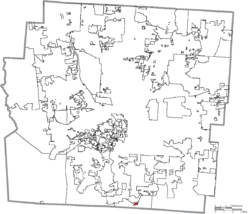
![]() Location of Lockbourne in Franklin County | |
Coordinates: 39°48′32″N82°58′14″W / 39.80889°N 82.97056°W Coordinates: 39°48′32″N82°58′14″W / 39.80889°N 82.97056°W | |
Country | United States |
State | Ohio |
County | Franklin, Pickaway County |
Area | |
• Total | 0.84 sq mi (2.17 km2) |
• Land | 0.79 sq mi (2.03 km2) |
• Water | 0.05 sq mi (0.14 km2) |
Elevation | 712 ft (217 m) |
Population (2020) | |
• Total | 236 |
• Density | 300.64/sq mi (116.09/km2) |
Time zone | UTC-5 (Eastern (EST)) |
• Summer (DST) | UTC-4 (EDT) |
ZIP code | 43137 |
Area code | 614 |
FIPS code | 39-44310 [3] |
GNIS feature ID | 1065015 [2] |
Website | www |
Lockbourne is a village in Franklin County and Pickaway County, Ohio, United States. The population was 236 at the 2020 census. Lockbourne is located near Rickenbacker International Airport, and had initially provided its original name of Lockbourne Air Force Base.
Lockbourne was laid out in the early 1830s. It takes its name from the locks of the Ohio and Erie Canal, on which it was situated. [4]
Picway Power Plant, a coal fired power plant, operated in Lockbourne from 1926 to 2015. It was owned by Columbus & Southern Ohio Electric, and later by American Electric Power (AEP). [5]
Lockbourne is located at 39°48′32″N82°58′14″W / 39.80889°N 82.97056°W (39.809008, -82.970528). [6]
According to the United States Census Bureau, the village has a total area of 0.80 square miles (2.07 km2), of which, 0.75 square miles (1.94 km2) is land and 0.05 square miles (0.13 km2) is water. [7]
Historical population | |||
---|---|---|---|
Census | Pop. | %± | |
1840 | 139 | — | |
1850 | 218 | 56.8% | |
1860 | 205 | −6.0% | |
1870 | 281 | 37.1% | |
1880 | 285 | 1.4% | |
1910 | 307 | — | |
1920 | 279 | −9.1% | |
1930 | 299 | 7.2% | |
1940 | 372 | 24.4% | |
1950 | 376 | 1.1% | |
1960 | 460 | 22.3% | |
1970 | 420 | −8.7% | |
1980 | 373 | −11.2% | |
1990 | 173 | −53.6% | |
2000 | 280 | 61.8% | |
2010 | 237 | −15.4% | |
2020 | 236 | −0.4% | |
U.S. Decennial Census [8] 2020 [9] |
At the 2010 census there were 237 people, 95 households, and 69 families living in the village. The population density was 316.0 inhabitants per square mile (122.0/km2). There were 108 housing units at an average density of 144.0 per square mile (55.6/km2). The racial makeup of the village was 97.9% White, 0.4% from other races, and 1.7% from two or more races. Hispanic or Latino people of any race were 2.5%. [10]
Of the 95 households 33.7% had children under the age of 18 living with them, 54.7% were married couples living together, 12.6% had a female householder with no husband present, 5.3% had a male householder with no wife present, and 27.4% were non-families. 21.1% of households were one person and 8.5% were one person aged 65 or older. The average household size was 2.49 and the average family size was 2.86.
The median age in the village was 38.9 years. 24.5% of residents were under the age of 18; 8% were between the ages of 18 and 24; 26.6% were from 25 to 44; 20.2% were from 45 to 64; and 20.7% were 65 or older. The gender makeup of the village was 47.7% male and 52.3% female.
At the 2000 census there were 280 people, 107 households, and 78 families living in the village. The population density was 2,950.5 people per square mile (1,201.2/km2). There were 114 housing units at an average density of 1,201.3 per square mile (489.1/km2). The racial makeup of the village was 99.64% White, and 0.36% from two or more races. Hispanic or Latino people of any race were 0.36%. [3]
Of the 107 households 26.2% had children under the age of 18 living with them, 56.1% were married couples living together, 8.4% had a female householder with no husband present, and 26.2% were non-families. 23.4% of households were one person and 12.1% were one person aged 65 or older. The average household size was 2.62 and the average family size was 3.05.
The age distribution was 25.4% under the age of 18, 5.7% from 18 to 24, 27.5% from 25 to 44, 25.7% from 45 to 64, and 15.7% 65 or older. The median age was 39 years. For every 100 females there were 105.9 males. For every 100 females age 18 and over, there were 97.2 males.
The median household income was $33,929 and the median family income was $38,125. Males had a median income of $26,875 versus $25,500 for females. The per capita income for the village was $14,802. About 5.1% of families and 9.5% of the population were below the poverty line, including 9.1% of those under the age of eighteen and 6.1% of those sixty five or over.
While Rickenbacker Airport is extremely close to Lockbourne, very few commercial flights land or take off at Rickenbacker, and many Columbus-area commercial flights are scheduled at John Glenn International Airport. Many smaller general aviation airports are also located close to Lockbourne, the closest of which is Bolton Field.
Road access to Lockbourne primarily revolves around U.S. Route 23 and Ohio State Route 317. The closest controlled-access highway is Interstate 270, a ring road connecting outer Columbus suburbs as well as Interstate 70 and Interstate 71.
Long Creek is a village in Macon County, Illinois, United States whose population was 1,328 at the 2010 census, and 1,282 at a 2018 estimate. It is included in the Decatur, Illinois Metropolitan Statistical Area.
New Germany is a city in Carver County, Minnesota, United States. The population was 372 at the 2010 census. A large proportion of the early settlers being natives of Germany caused the name to be selected.
Aberdeen is a village in Huntington Township, Brown County, Ohio, United States, along the Ohio River 50 miles (80 km) southeast of Cincinnati. The population was 1,638 at the 2010 census.
Warsaw is a village in Coshocton County, Ohio, United States, along the Walhonding River. The population was 682 at the 2010 census.
New Washington is a village in Cranberry Township in Crawford County, Ohio, United States. The population was 967 at the 2010 census.
Middleburg Heights is a city and a suburb of Cleveland in Cuyahoga County, Ohio, United States. The population held steady at approximately sixteen thousand throughout the first two decades of the twenty-first century.
Brice is a village in Franklin County, Ohio, United States, on the southeast side of the Columbus metropolitan area. The population was 93 at the 2020 census. The village theme is "An Early American Village".
Groveport is a city in Franklin County, Ohio, United States. It is a suburb of Columbus. The population was 6,009 at the 2020 census.
Addyston is a village in Miami Township, Hamilton County, Ohio, United States, along the Ohio River. The population was 938 at the 2010 census.
Mowrystown is a village in Highland County, Ohio, United States. The population was 360 at the 2010 census.
Brinkhaven is nestled on the edge of Knox County, Ohio, on the east side of the Mohican River. Originally surveyed in 1838, the village has been known as Nonperil, Mount Holly, Gann, and finally Brinkhaven. In the early 1900’s it was a village on the rise from the railroad business, now it is a quiet and quaint home to its 121 residents.
St. Louisville is a village in Licking County, Ohio, United States, along the North Fork of the Licking River. The population was 373 at the 2010 census.
Shawnee is a village in Perry County, Ohio, United States. The population was 655 at the 2010 census. It is nine (9) miles south of the county seat of New Lexington.
Darbyville is a village in Pickaway County, Ohio, United States. The population was 222 at the 2010 census.
Limaville is a census-designated place (CDP) and former village in Stark County, Ohio, United States. The population was 151 at the 2010 census. It is part of the Canton–Massillon Metropolitan Statistical Area.
Beech Bottom is a village in Brooke County, West Virginia, United States, situated along the Ohio River. The population was 523 at the 2010 census. It is part of the Weirton–Steubenville metropolitan area.
Taycheedah is a town in Fond du Lac County, Wisconsin, United States. The population was 3,666 at the 2000 census. The census-designated places of St. Peter and Taycheedah and the unincorporated communities of Hopokoekau Beach, Linden Beach, Minawa Beach, Peebles, Silica, and Welling Beach are located in the town, as well as Malone, which is partially located in the town.
Wilson is a village in Belmont and Monroe counties in the U.S. state of Ohio. It is part of the Wheeling, West Virginia Metropolitan Statistical Area. The population was 125 at the 2010 census.
Gratiot is a village in Licking and Muskingum counties in the U.S. state of Ohio. The population was 221 at the 2010 census.
Verona is a village in Montgomery and Preble counties in the U.S. state of Ohio. The population was 494 at the 2010 census. It is part of the Dayton Metropolitan Statistical Area.