Franklin County is a county in the U.S. state of Ohio. As of the 2020 census, the population was 1,323,807, making it the most populous county in Ohio. Most of its land area is taken up by its county seat, Columbus, the state capital and most populous city in Ohio. The county was established on April 30, 1803, less than two months after Ohio became a state, and was named after Benjamin Franklin. Originally, Franklin County extended north to Lake Erie before it was subdivided into smaller counties. Franklin County is the central county of the Columbus, Ohio Metropolitan Statistical Area.

Genoa Township is one of the eighteen townships of Delaware County, Ohio, United States. The 2020 census found 24,806 people in the township.

Hilltop is one of the largest neighborhoods in Columbus, Ohio, located west of Franklinton and Downtown. The Greater Hilltop area contains newer and historic neighborhoods, schools, various stores, industrial areas, and recreational facilities. The development pattern is considered a distinct suburb. The majority of the area is predominantly single family residential.

Blacklick is a small unincorporated community in southern Jefferson Township, Franklin County, Ohio, United States. Blacklick is also included in the Columbus Metropolitan area.

Chesterfield Township is one of the twelve townships of Fulton County, Ohio, United States. The 2020 census found 938 people in the township.

Dover Township is one of the twelve townships of Fulton County, Ohio, United States. The 2020 census found 1,621 people in the township.
Franklin Township is one of the twelve townships of Fulton County, Ohio, United States. The 2020 census found 695 people in the township. The Township Hall is located at the hamlet of Zone.

Gorham Township is one of the twelve townships of Fulton County, Ohio, United States. The 2020 census found 2,168 people in the township.
Hilliard City School District is a public school district with its headquarters in Columbus, Ohio. The school district contains all of what was once Norwich and Brown townships. This includes Hilliard.
The Near East Side is a neighborhood located near downtown Columbus, Ohio, made up of several neighborhoods: Mount Vernon, King-Lincoln Bronzeville, Eastgate, Franklin Park, Nelson Park, Olde Towne East, and Woodland Park.

Downtown Columbus is the central business district of Columbus, Ohio. Downtown is centered on the intersection of Broad and High Streets, and encompasses all of the area inside the Inner Belt. Downtown is home to most of the tallest buildings in Columbus.
Columbus, the state capital and Ohio's largest city, has numerous neighborhoods within its city limits. Neighborhood names and boundaries are not officially defined. They may vary or change from time to time due to demographic and economic variables.

Prairie Township is one of the seventeen townships of Franklin County, Ohio, United States. As of the 2020 census the population was 17,415. Prairie Township is on the far west side of Franklin County touching the east side of Madison County.

Kitts Hill is an unincorporated community in western Lawrence Township, Lawrence County, Ohio, United States. It has a post office with the ZIP code 45645. It lies along State Route 141 northeast of the city of Ironton, the county seat of Lawrence County. It has a community center that was previously Deering Local School District in the area. The majority of Pre-K through 12th grade education is provided by the Rock Hill Local School District, although very small portions of the area are served by the Dawson-Bryant Local School District.
Columbus Messenger Newspapers is a bi-weekly newspaper organization started in 1974. It publishes six free or by subscription, independently owned newspapers: the Westside Messenger, the South andCanal Winchester Messenger, the Groveport Messenger, the Grove City Messenger, and the Madison Messenger, covering communities around Columbus, Ohio, and Madison County.

Ida is an unincorporated community and census-designated place (CDP) in Monroe County in the U.S. state of Michigan. The CDP had a population of 790 at the 2020 census. The community is mostly within Ida Township with a smaller portion extending north into Raisinville Township.

Merritt is an unincorporated community in Missaukee County in the U.S. state of Michigan. The community is centered between Butterfield Township to the south and Enterprise Township to the north. As an unincorporated community, Merritt has no legally defined boundaries or population statistics of its own but does have its own post office with the 49667 ZIP Code.
The community of Forest Park consists of almost 2900 private residential properties, plus apartments, condominiums, commercial properties, city-owned parks and schools, in approximately 1.4 square miles (3.6 km2) of the Northland area of northeast Columbus, Ohio. These properties adjoin a total of 132 distinct streets and courts maintained by the City of Columbus. The community's approximate center is near the intersection of Karl Road and Sandalwood Place in Columbus.
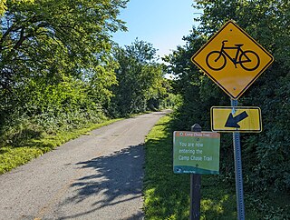
The Camp Chase Trail is a paved multi-use trail in Madison and Franklin counties in the U.S. state of Ohio. It serves as the Southwest Columbus segment of the 326-mile (525 km) Ohio to Erie Trail. The entire length of the Camp Chase Trail is part of the Great American Rail-Trail, U.S. Bicycle Route 21 and U.S. Bicycle Route 50.