Lincoln Village, Ohio

Last updated
Lincoln Village, Ohio
Lincoln Village Sign (cropped).jpeg
Sign and gateway into Lincoln Village
OHMap-doton-Lincoln Village.png
Location of Lincoln Village, Ohio
Coordinates: 39°57′11″N83°07′40″W / 39.95306°N 83.12778°W / 39.95306; -83.12778
Country United States
State Ohio
County Franklin
Township Prairie
Area
[1]
  Total1.82 sq mi (4.73 km2)
  Land1.82 sq mi (4.73 km2)
  Water0.00 sq mi (0.00 km2)
Elevation
[2]
909 ft (277 m)
Population
 (2020)
  Total9,702
  Density5,316.16/sq mi (2,052.34/km2)
Time zone UTC-5 (Eastern (EST))
  Summer (DST) UTC-4 (EDT)
FIPS code 39-43792 [3]
GNIS feature ID2393101 [2]

Lincoln Village is a census-designated place (CDP) in Prairie Township, Franklin County, Ohio, United States. It is centered near the intersection of US 40 and I-270 on the west side of Columbus. As of the 2020 census, the population was 9,702.

Contents

Lincoln Village was started in 1955 as a planned community by a real estate subsidiary of Nationwide Insurance.

History

Ohio Farm Bureau Federation President and CEO Murray Lincoln had aspired to create a suburban "village" since the early 1940s. Lincoln, as the head of what would become Nationwide Insurance from 1920 to 1948, initiated work on the Lincoln Village project in the early 1950s with the support of the U.S. Cooperative Movement. [4] Lincoln was able to "sell" the Cooperative ideology to Ohio individual farmers, and viewed co-ops as "an answer to Communism in Europe and Asia, and as a balance wheel against unfettered private enterprise in the U.S."[ citation needed ] After founding several co-op and non co-op enterprises, Lincoln was able to fund the development of Lincoln Village with assets made from these corporations (which totaled $133,510,000).[ citation needed ] Lincoln's People's Development Corporation was formed to build Lincoln Village. The price of this project was about $30,000,000 USD.[ citation needed ] The plan for Lincoln Village included 9 miles (14 km) of streets, sewers, a pumping station, and a million-gallon water pump. Lincoln Village was built for 10,000 inhabitants, and was set around a 20-acre (8.1 ha) civic center.[ citation needed ] In 1953, bulldozers completed grading of 1,270 acres (510 ha) of farmland in western Columbus for the construction of Lincoln Village, with churches, a school, wooded park, playgrounds, and a library. A shopping center would also be built. Housing in the village was to include apartment buildings and single family homes priced between $9,000 to $16,000. [5]

Geography

Lincoln Village is located in west-central Franklin County.

The Pennsylvania Railroad borders Lincoln Village to the north, Sullivant Avenue to the south, and Interstate 270 to the east. The western border of Lincoln Village follows Hilliard Rome Road and Norton Road, the larger northwest portion by Hilliard-Rome Road and the smaller southwest portion by Norton Road. U.S. Route 40 (the National Road, known as W. Broad Street within the community) runs through the center of town, leading east 9 miles (14 km) to the center of Columbus. The city of Columbus borders Lincoln Village to the north, west, and south; a portion of Franklin Township is to the east, across I-270.

According to the United States Census Bureau, Lincoln Village has a total area of 1.83 square miles (4.75 km2), all land. [6]

Adjacent neighborhoods include New Rome, Rome Heights, Cherry Creek, and National Pike Little Farms.

Demographics

Historical population
CensusPop.Note
2020 9,702
U.S. Decennial Census [7]

As of the census [8] of 2010, there were 9,032 people, 3,734 households, and 2,265 families residing in the CDP. The racial makeup is 82.1% White, 6.3% Black or African American, 0.4% Native American, 0.9% Asian, 0% Pacific Islander, 7.3% from other races, and 3% from two or more races. Hispanic or Latino people of any race were 10.7% of the population.

There were 3,734 households, out of which 24.3% had children under the age of 18 living with them, 37.9% were married couples living together, 15.8% had a female householder with no husband present, and 39.3% were non-families. 31.8% of all households were made up of individuals living alone, and 12.9% had someone living alone who was 65 years of age or older. The average household size was 2.42 and the average family size was 3.04.

The population was spread out, with 23.6% under the age of 18, 8.3% from 18 to 24, 26.7% from 25 to 44, 26.9% from 45 to 64, and 14.5% who were 65 years of age or older. The median age was 38.2 years. For every 100 females, there were 96.8 males. For every 100 females age 18 and over, there were 93.8 males.

The median income for a household in the CDP was $41,250, and the median income for a family was $49,199. Male, full-time, year-round workers had a median income of $31,804 versus $30,807 for females. The per capita income is $19,180. About 12.8% of families and 15.8% of the population were below the poverty line, including 24.0% of those under age 18 and 5.6% of those age 65 or over.

Lincoln Village Plaza Lincoln Village Plaza (cropped).jpeg
Lincoln Village Plaza

Economy

Lincoln Village Plaza is a major shopping center on West Broad Street in Lincoln Village. Major tenants include Giant Eagle, Joann Fabrics, and the Westland Area Library.

Education

Westland Area Library Westland Area Library (cropped).jpeg
Westland Area Library

Lincoln Village is part of the South-Western City School District. [9] As of the 2010 Census, 75.8% of the residents of Lincoln Village age 25 and over were high school graduates or higher.

Artist's depiction of the new Prairie Lincoln, set to hold 600 students in nearly 70,000 square feet. PrairieLincolnEntrance.jpg
Artist's depiction of the new Prairie Lincoln, set to hold 600 students in nearly 70,000 square feet.

Both Lincoln Village North and South have an elementary school. Located on Amesbury Way in Lincoln Village North is Prairie Lincoln Elementary School. Prairie Lincoln was rebuilt in 2015 to holds 600 students. [10] In Lincoln Village South, Stiles Elementary School is located on Stiles Avenue. It was rebuilt at the same time to the same capacity as Prairie Lincoln. [11]

Parks

Carl Frye Park is the main park in Lincoln Village North. It is located at 318 Darbyhurst Road. [12] Located between Beacon Hill Road and Deerfield Road, Friendship Park is Lincoln Village North's second park. [13] Lakota Park is Lincoln Village South's only park.

See also

Related Research Articles

<span class="mw-page-title-main">Franklin County, Ohio</span> County in Ohio, United States

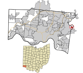
Franklin County is a county in the U.S. state of Ohio. As of the 2020 census, the population was 1,323,807, making it the most populous county in Ohio. Most of its land area is taken up by its county seat, Columbus, the state capital and most populous city in Ohio. The county was established on April 30, 1803, less than two months after Ohio became a state, and was named after Benjamin Franklin. Originally, Franklin County extended north to Lake Erie before it was subdivided into smaller counties. Franklin County is the central county of the Columbus, Ohio Metropolitan Statistical Area.

<span class="mw-page-title-main">Delaware County, Ohio</span> County in Ohio, United States

Delaware County is a county located in the central portion of the U.S. state of Ohio. As of the 2020 census, the population was 214,124. Its county seat and largest city is Delaware.

<span class="mw-page-title-main">Village of Oak Creek, Arizona</span> Community in Yavapai County, Arizona

Village of Oak Creek is an unincorporated community located within Big Park a census-designated place (CDP) in Yavapai County, Arizona, United States. The population was 6,147 at the 2010 census, up from 5,245 in 2000. Big Park is the name of the CDP while the community is more commonly known as the Village of Oak Creek (VOC), and is a bedroom community for Sedona, located seven miles away. Tourism and service to retirees and second-home owners are the basis for the local economy. Big Park, the pioneers' name for the large open area that became the Village of Oak Creek in the early 1960s, is set among scenic red-rock buttes and canyons. The Bell Rock scenic area adjoins the north end of VOC, and the town is surrounded by the Coconino National Forest. A Forest Service Visitor Center is located at the south end of VOC.

<span class="mw-page-title-main">Franklin Grove, Illinois</span> Village in Illinois, United States

Franklin Grove is a village in Lee County, Illinois, United States. The population was 1,021 at the 2010 census, down from 1,052 in 2000.

<span class="mw-page-title-main">Prairie Village, Kansas</span> City in Kansas, United States

Prairie Village is a city in Johnson County, Kansas, United States, and located within the Kansas City Metropolitan Area. As of the 2020 census, the population of the city was 22,957.

<span class="mw-page-title-main">Ross, Ohio</span> Census-designated place in Ohio, United States

Ross is a census-designated place (CDP) in Ross Township, Butler County, Ohio, United States. The population was 3,478 at the 2020 census. Ross sits along U.S. Route 27 between Cincinnati, Ohio and Oxford, Ohio. Ross is part of the Cincinnati metropolitan area.

<span class="mw-page-title-main">Park Layne, Ohio</span> Census-designated place in Ohio, United States

Park Layne is a census-designated place (CDP) in Bethel Township, Clark County, Ohio, United States. The population of the CDP was 4,248 at the 2020 census. It is part of the Springfield, Ohio Metropolitan Statistical Area. Park Layne became a CDP in the 1980 United States Census.

<span class="mw-page-title-main">Bexley, Ohio</span> City in Ohio, United States

Bexley is a suburban city in Franklin County, Ohio, United States. The population was 13,928 at the 2020 census. Founded as a village, the city of Bexley is a suburb of Columbus, the Ohio state capital, situated on the banks of Alum Creek next to Driving Park and Wolfe Park, just east of the Franklin Park Conservatory. It is horizontally bisected by the National Road, serving as a reminder of Bexley's origins as a merger between the prestigious Bullitt Park neighborhood to the north, and the Lutheran college community of Pleasant Ridge to the south.

Blacklick Estates is a census-designated place (CDP) in Franklin County, Ohio, United States: partly in Madison Township and partly in Truro Township. As of the 2020 census the population was 8,990.

<span class="mw-page-title-main">Grove City, Ohio</span> City in Ohio, United States

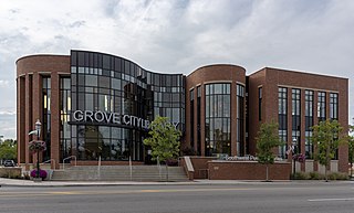
Grove City is a city in Franklin County, Ohio, United States, founded in 1852. It is a suburb of Columbus. The population was 41,252 according to the 2020 Census.

<span class="mw-page-title-main">Hilliard, Ohio</span> City in Ohio, United States

Hilliard is a city in Franklin County, Ohio, United States. The population was 37,114 at the 2020 census. It is a suburb of Columbus and part of Norwich Township. Hilliard is home to the Early Television Museum, the second largest First Responders Park in the United States, and Heritage Rail Trail. Hilliard also has the only flag pole from the World Trade Center that is not in a museum. The flag pole is located in front of the fire department on Northwest Parkway. The Hilliard Historical Society maintains a historical village near the Franklin County Fairgrounds.

<span class="mw-page-title-main">Huber Ridge, Ohio</span> Census-designated place in Ohio, United States

Huber Ridge is a census-designated place (CDP) in Blendon Township, Franklin County, Ohio, United States. The population was 4,940 at the 2020 census.

<span class="mw-page-title-main">Lake Darby, Ohio</span> Census-designated place in Ohio, United States

Lake Darby is an unincorporated community and census-designated place in Franklin County, Ohio, United States, located mostly in Prairie Township and partly in Brown Township. It is more commonly known among locals as Darby Estates, which is also the name of the older housing development there, with the newer development called "West Point". As of the 2020 census, the CDP had a population of 4,731.

<span class="mw-page-title-main">New Rome, Ohio</span> Unincorporated community in Ohio, United States

New Rome is an unincorporated community in eastern Prairie Township, Franklin County, Ohio, United States, located on the west side of the Columbus, Ohio metropolitan area. It was originally incorporated as a village in 1947, and was dissolved in 2004. It encompassed an area roughly defined by Lawrence Ave., Norton Rd., Green St., and an unnamed alley paralleling Broad St. to the north. The population was 60 at the 2000 census.

<span class="mw-page-title-main">Whitehall, Ohio</span> City in Ohio, United States

Whitehall is a city in the U.S state of Ohio, located 6.6 miles (10.6 km) east of the state capital of Columbus in Franklin County. Whitehall had a population of 20,127 in the 2020 census. Founded in 1947, Whitehall is a growing suburb of Columbus. Per the U.S. Census Bureau, Whitehall's population is culturally and racially diverse, with over 50% of the population identifying as black, African American, Hispanic or Latino, with over 20% speaking a language other than English at home.

<span class="mw-page-title-main">Brady Lake, Ohio</span> Census-designated place in Ohio, United States

Brady Lake is an unincorporated census-designated place and former village in Portage County, Ohio, United States. The population was 1,222 at the 2020 census. Incorporated in 1927, it originally developed as an amusement park and summer resort that opened in 1891. It was formed from a small portion of Franklin Township and became fully independent of the township in 1993. The village was named after the lake it borders, Brady Lake, which in turn was named for Captain Samuel Brady, who hid in the lake around 1780 while being pursued by a band of local Native Americans.

<span class="mw-page-title-main">Portage Lakes, Ohio</span> Census-designated place in Ohio, United States

Portage Lakes is a census-designated place in Summit County, Ohio, United States. The population was 6,407 at the 2020 census. A suburb directly south of Akron, the community takes its name from the encompassing Portage Lakes.

<span class="mw-page-title-main">Parkland, Washington</span> Census-designated place in Washington, United States

Parkland is a census-designated place (CDP) in Pierce County, Washington. The population was 35,803 at the time of the 2010 census and had grown to 38,623 as of the 2020 census. It is an unincorporated suburb of the city of Tacoma and is home to Pacific Lutheran University.

<span class="mw-page-title-main">Alum Creek, West Virginia</span> Census-designated place in West Virginia, United States

Alum Creek is a census-designated place (CDP) in Kanawha and Lincoln counties along the Coal River in the U.S. state of West Virginia. It includes the unincorporated communities of Alum Creek, Forks of Coal, and Priestley. The CDP had a population of 1,749 at the 2010 census, down from 1,839 at the 2000 census.

<span class="mw-page-title-main">Camp Dennison, Ohio</span> Census-designated place in Ohio, United States

Camp Dennison is a census-designated place (CDP) just outside Indian Hill in southern Symmes Township, Hamilton County, Ohio, United States. It has a post office with the ZIP code 45111. The population was 384 at the 2020 census.

References

  1. "ArcGIS REST Services Directory". United States Census Bureau. Retrieved September 20, 2022.
  2. 1 2 U.S. Geological Survey Geographic Names Information System: Lincoln Village, Ohio
  3. "U.S. Census website". United States Census Bureau . Retrieved 2008-01-31.
  4. "Lincoln Village: For planned community, the model has changed". The Columbus Dispatch. Retrieved 2020-01-29.
  5. "INSURANCE: Man with a Mission". Time. 1953-08-17. Retrieved 2015-12-15.
  6. "Geographic Identifiers: 2010 Census Summary File 1 (G001), Lincoln Village CDP, Ohio". American FactFinder. U.S. Census Bureau. Archived from the original on February 13, 2020. Retrieved July 5, 2016.
  7. "Census of Population and Housing". Census.gov. Retrieved June 4, 2016.
  8. "U.S. Census website" . Retrieved 18 October 2017.
  9. "2020 CENSUS - SCHOOL DISTRICT REFERENCE MAP: Franklin County, OH" (PDF). U.S. Census Bureau. p. 4 (PDF p. 5/10). Retrieved 2024-02-19. UNI 04480*
  10. "Building Facts - PLES". ples.swcsd.us. Archived from the original on 2015-05-11. Retrieved 2015-12-15.
  11. "Building Facts - SES". ses.swcsd.us. Archived from the original on 2016-04-18. Retrieved 2015-12-15.
  12. "Carl Frye Park Map". www.neighborhoodlink.com. Retrieved 2015-12-15.
  13. "Friendship Park Map". www.neighborhoodlink.com. Retrieved 2015-12-15.