Driving Park

Last updated
Driving Park
Driving Park.JPG
Driving Park and Recreation Center
Driving Park
Coordinates: 39°57′0″N82°57′0″W / 39.95000°N 82.95000°W / 39.95000; -82.95000
Country United States
State Ohio
County Franklin
City Columbus

Driving Park is an urban residential area on the Near East Side of Columbus, Ohio just south of Interstate 70. Mainly a middle-class, predominantly African American neighborhood, Driving Park and its surrounding neighborhoods consist of an area of 17,730 residents. Driving Park received its name from its historic past as a large racing complex, first for horses and later for automobiles.

Contents

History

Driving Park received its name from its historic past as a large equine racing complex for horses and eventually automobiles during the 19th and early 20th centuries. The Columbus Ohio Driving Realty Company bought the land in 1892. [1] Columbus residents traveled to Driving Park to enjoy the exciting horse races being held in the area. When automobiles came on the scene during the 1900s, the track was converted to allow auto racing. The largely flat, stretched oval design made it possible for drivers to set many records at the racetrack. One major event was the world’s first 24-hour endurance race in 1905. [2] The track hosted 200-mile events during the 1912 and 1913 AAA Championship Car seasons, won by Spencer Wishart and Ralph Mulford, respectively. [3] The community of Driving Park at one time was a small one, consisting of employees of the racetrack. Even though the racetrack was abandoned in the 1930s, the community continued to grow.

The construction of I-670 and I-70 resulted in demolition of much of Columbus’ predominantly African-American neighborhoods to the east; as a result African Americans moved further south. At one point the community was thriving with a theater and many diverse commercial outlets along E. Livingston Avenue and E. Whittier Street.

Historic neighborhoods exist on the south side of E. Livingston Avenue bordered by Frebis Avenue, where many middle-class families currently reside. On the corner of E. Livingston and Linwood Avenue stands a 19th-century mansion that was a stop on the Underground Railroad. The area has many beautiful small middle-class homes built during the 1940s. Larger, older houses called "foursquares" (slang for American Foursquare) built during the 1900s or 1930s still remain as either single family or partitioned as doubles. Similar to other areas of Columbus, such as Victorian Village and the Short North, this area has many beautiful 19th-century homes that were owned by notable residents. In fact, the style of the homes vary to include echoes of German Village to the west part of the neighborhood, Olde Towne East to the north, and Bexley to the east. [4] Driving Park was among the city’s first streetcar suburbs, developing with the extension of streetcar lines to what used to be outlying areas of Columbus. Residents currently living in the Driving Park area are requesting that the area be renamed the “Streetcar District,” to spark interest and promote the history of the area.


Geography

View along Alum Creek Drive, a border of the district of Driving Park Alum Creek Drive.JPG
View along Alum Creek Drive, a border of the district of Driving Park

It neighbors many notable areas including Livingston Park, Old Oaks Historic District, Bryden Road Historic District, and the King-Lincoln Bronzeville District, all with the common thread of the notable Livingston Avenue Corridor which was part of one of Columbus' first streetcar suburbs. When the neighborhood is referenced, its boundaries generally consist of Mooberry Street on the north, Alum Creek Drive on the east, East Whittier Street on the south, and Kelton to the west. The Driving Park Area Commission recognizes the neighborhood's borders as I-70 on the north, N&W Railway on the east, East Whittier Street on the south, and Struder Avenue on the west. [5] Further reference places the community directly in between Bexley and German Village.

Transportation

The Central Ohio Transit Authority has Local Lines that run through the district including lines 1, 7, and 11. Line 1 makes a stop on Livingston and connects to Line 1 Cleveland at High and Broad Streets. From there the bus travels to Dublin, Ohio Health, Grandville Rd. and Reynolds Park and Ride. Line 7 has a stop on Whittier that travels to downtown, the courthouse, and a US Post Office. Line 11 has a stop at the corner of Oak and Bryden that travels to downtown, Grant Medical Center, Columbus Metropolitan Library, DeVry Institute of Technology, Alum Crest High School, Eastland Mall, and Gender Road Town Center. [6]

Structures and landmarks

The Columbus Driving Park is a cultural landmark that defines the district. The Columbus, Ohio Driving Realty Company bought the land and located it in between Ellsworth and Seymour Avenue. It is most famous for holding the first 24-hour automobile race on July 3, 1905. The race was held only ten years after the first automobile race and only two years after Ford Motors was created. There were three cars including drivers Charles and George Soules, Oscar Lear, Ballanger, and Feasal who drove 1,015 miles throughout the whole race. The Soules brothers won the race and their prize was a silver cup said to be worth $500 at the time. There were eleven other supporting races held at the track including The Columbus Motor Derby and The Novelty Race. Among the many races held at the track there were many other noteworthy events held in this heart of the neighborhood including the Franklin County Fair in both 1910 and 1917 and became a landing strip for the test flight of the Model B airplane built by the Wright Brothers. [7]

Residential

In the early years of Driving Park, the jobs offered by the racetrack brought in its first residents. What started as more of an area for recreation turned into a more valuable residential area. When the racetrack was sold to the Driving Park Realty Company in 1926, the land was subdivided. Unique homes began to rise west of Fairwood Avenue, attracting middle-class shop owners and professionals.

As of January 2012, there were a total of 218 vacant homes in Driving Park according to the city's code-enforcement office.

Current residents are hopeful that the Nationwide Children's Hospital expansion and improvements along Livingston Avenue will attract hospital employees to the area. [8]

Recreation

Driving Park and Recreation Center Driving Park and Recreation Center.JPG
Driving Park and Recreation Center

The Driving Park and Recreation Center is located next to the railroad inside of the district and is a part of the Columbus Recreations and Parks facilities. In order to gain access to the facilities one must purchase a leisure card. There are many programs and classes geared towards children and young adults such as basketball, cooking, weight lifting, and line dancing. [9]

Education

The Fairwood Alternative Elementary School in the school district of Columbus City Schools is located near the north border of the district on the corner of Fairwood Avenue and Mooberry Street. Fairwood currently has 380 students enrolled in pre-K – grade 6. [10]

Notable residents

See also

Related Research Articles

<span class="mw-page-title-main">Bexley, Ohio</span> City in Ohio, United States

Bexley is a suburban city in Franklin County, Ohio, United States. The population was 13,928 at the 2020 census. Founded as a village, the city of Bexley is a suburb of Columbus, the Ohio state capital, situated on the banks of Alum Creek next to Driving Park and Wolfe Park, just east of the Franklin Park Conservatory. It is horizontally bisected by the National Road, serving as a reminder of Bexley's origins as a merger between the prestigious Bullitt Park neighborhood to the north, and the Lutheran college community of Pleasant Ridge to the south.

<span class="mw-page-title-main">Victorian Village</span> Neighborhood of Columbus in Franklin, Ohio, United States

Victorian Village is a neighborhood in Columbus, Ohio, United States, north and near west of downtown. It is an established neighborhood built when a streetcar line first ran along Neil Avenue around 1900 with a fair number of established trees for an urban setting. To preserve, protect and enhance the unique architectural and historical features, the Victorian Village Historic District was established in 1973. Columbus Monthly named this neighborhood the top place to live for Arts and Entertainment, with fun right around the corner in the Short North as its neighborhood hangout.

<span class="mw-page-title-main">Arena District</span> Neighborhood of Columbus in Franklin, Ohio, United States

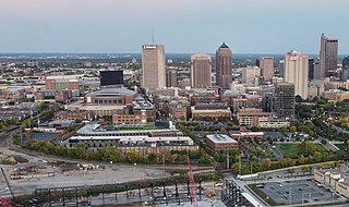
The Arena District is a mixed-use planned development and neighborhood in Columbus, Ohio. The site was developed through a partnership between Nationwide Realty Investors, Ltd., the City of Columbus and private investors. Interpretation of the boundaries of the district are evolving as the neighboring blocks around the original 75-acre (300,000 m2) site have seen additional commercial and residential development. The Arena District is named for Nationwide Arena.

<span class="mw-page-title-main">Westgate (Columbus, Ohio)</span> Neighborhood of Columbus in Franklin, Ohio, United States

Westgate is a community within the Hilltop area of Columbus, Ohio. It was partially constructed on land that formerly housed the American Civil War Camp Chase and a Confederate prison. After the Civil War, the land was purchased by Joseph Binns and his associates with the intent to start a Quaker community. These plans failed to materialize and the land was developed as a "streetcar suburb" in the 1920s. Located 4 miles (6.4 km) west of downtown, the neighborhood is home to Westgate Park and Recreation Center, Westgate Alternative Elementary School, St. Mary Magdalene Church and school, and Parkview United Methodist Church. 4,500 residents live within the Westgate boundaries, most in single family houses.

<span class="mw-page-title-main">Franklinton (Columbus, Ohio)</span> Neighborhood in Columbus, Ohio

Franklinton is a neighborhood in Columbus, Ohio, just west of its downtown. Settled in 1797, Franklinton is the first American settlement in Franklin County, and was the county seat until 1824. As the city of Columbus grew, the city annexed and incorporated the existing settlement in 1859. Franklinton is bordered by the Scioto River on the north and east, Harmon Avenue on the east, Stimmel Road and Greenlawn Avenue on the south, and Interstate 70 on the west. Its main thoroughfare is West Broad Street, one of the city's two main roads.

The Near East Side is a neighborhood located near downtown Columbus, Ohio, made up of several neighborhoods: Mount Vernon, King-Lincoln Bronzeville, Eastgate, Franklin Park, Nelson Park, Olde Towne East, and Woodland Park.

<span class="mw-page-title-main">Downtown Columbus, Ohio</span> Neighborhood in Columbus, Ohio

Downtown Columbus is the central business district of Columbus, Ohio. Downtown is centered on the intersection of Broad and High Streets, and encompasses all of the area inside the Inner Belt. Downtown is home to most of the tallest buildings in Columbus.

<span class="mw-page-title-main">Olde Towne East</span> Neighborhood of Columbus, Ohio, United States

Olde Towne East is a neighborhood located in the historical Near East Side of Columbus, Ohio and is one of Columbus' oldest neighborhoods. The area has over 1,000 homes, some as old as the 1830s, and more than 50 architectural styles as a result of its history. These homes were built by many of the famous individuals of Columbus including industrialists, lawyers, judges, teachers, architects, mayors, governors, and legislators, many of whom shaped the city.

<span class="mw-page-title-main">Brewery District</span> Neighborhood of Columbus in Franklin, Ohio, United States

The Brewery District, traditionally known as the Old German Brewing District, is a neighborhood located in Columbus, Ohio. Located just south of the central business district and west of German Village, it is bounded by Interstate 70 on the north, South Pearl Street on the east, Greenlawn Avenue on the south, and the Scioto River on the west.

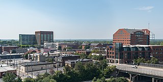
Columbus, the state capital and Ohio's largest city, has numerous neighborhoods within its city limits. Neighborhood names and boundaries are not officially defined. They may vary or change from time to time due to demographic and economic variables.

<span class="mw-page-title-main">Old Oaks Historic District</span> Neighborhood in Columbus in Franklin, Ohio, United States

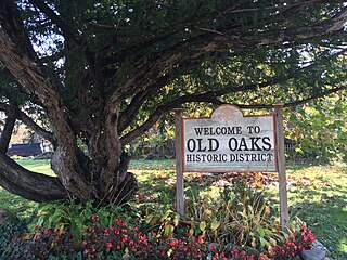
Old Oaks Historic District, or Old Oaks, is a neighborhood just south and east of downtown Columbus, Ohio and is an example of a streetcar suburb in the city.

<span class="mw-page-title-main">Berwick (Columbus, Ohio)</span> Neighborhood of Columbus in Franklin, Ohio, United States

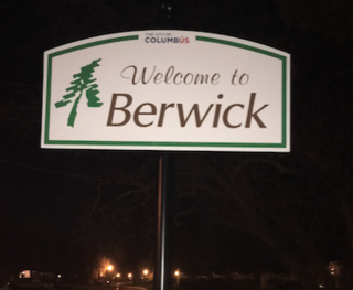
Berwick is a residential neighborhood located on the east side of Columbus, Ohio. Berwick is characterized by its warm nature and welcoming community atmosphere, as well as its diverse population, including significant numbers of African American and Jewish citizens. The median household income is higher than the state average at $51,048, and the average household net worth is $509,793. The median age of residents is 52. Notable Columbus citizens, including Heisman Trophy Winner Archie Griffin and Columbus Mayor Michael B. Coleman, have resided in the area.

<span class="mw-page-title-main">Geography of Columbus, Ohio</span> Topography, climate and cityscape in the city

The city of Columbus is located in central Ohio at the confluence of the Scioto and Olentangy rivers. The region is dominated by a humid continental climate, characterized by hot, muggy summers and cold, dry winters.
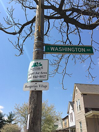
<span class="mw-page-title-main">Woodland Park (Columbus, Ohio)</span> Neighborhood of Columbus in Franklin, Ohio, United States

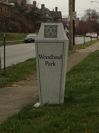
Woodland Park is a residential neighborhood located in the Near East Side of Columbus, Ohio that houses approximately 1,500 residents. The neighborhood was previously home to such figures as artist Emerson Burkhart, cartoonist Billy Ireland, and judge William Brooks. Established in the early 20th century, Woodland Park has grown from its planned neighborhood roots into a neighborhood that contains various faith communities, schools, sources of entertainment and recreation, and borders an extension of the Ohio State University medical center.

<span class="mw-page-title-main">Weinland Park</span> Neighborhood of Columbus in Franklin, Ohio, United States

Weinland Park is a neighborhood north of downtown Columbus, Ohio and encompassed by the boundaries of the University District. A development boom in the 1930s and 1940s resulting from new streetcar lines and the blossoming of factories brought working and middle-class families to the neighborhood. Current housing stock consists primarily of single family residential buildings that have been converted to rentals or multifamily housing. Row-homes and apartment buildings are also ubiquitous in the neighborhood. Renters currently outnumber owners. Commercial and entertainment facilities are concentrated on the North High Street corridor, but also pocket the inner part of the neighborhood as well. Weinland Park saw the sapping of its population and wealth with the rise of newer suburbs ringing the outer reaches of the city and the collapse of local industry and streetcar lines. The neighborhood has been plagued with crime and drug problems for decades but has recently seen a flood of new investment that has brought growth and revitalization to this long struggling neighborhood. Investment into the community includes the South Campus Gateway providing retail and residential finished in 2005, and a new food district and employment center.

<span class="mw-page-title-main">Franklin Park (Columbus, Ohio)</span> Place

Franklin Park is a neighborhood located on the Near East Side of Columbus, Ohio. Both the historic neighborhood and landmark, the Franklin Park Conservatory and Botanical Gardens, are named after the 88-acre park.

<span class="mw-page-title-main">Southern Orchards</span> Place

Southern Orchards is an established neighborhood near the south side of Columbus, Ohio. It is located immediately southeast of downtown and is the 23rd most walkable neighborhood in Columbus with 3,538 residents. The neighborhood is the target of revitalization and beautification largely due to its anchor institution Nationwide Children's Hospital and a renewed interest in urban living in the city's core. Since 2008, more than 90 properties have been improved through the hospital’s Healthy Homes program and continued revitalization is occurring along the major streets of Livingston and Parsons Avenues as the city moves to reconnect downtown to its surrounding neighborhoods.

<span class="mw-page-title-main">Trolley District</span> Historic site in Columbus, Ohio

The Trolley District is a mixed-use complex in Columbus, Ohio. The three-acre (1.2 ha) site houses the East Market, a public market and food hall, as well as two bars, restaurants, a brewery, and event space, with plans for neighboring apartments. The property is located in the city's Franklin Park neighborhood and is a contributing part of the Columbus Near East Side District, listed on the National Register of Historic Places.

<span class="mw-page-title-main">CBUS</span> Bus line in Columbus, Ohio

The CBUS was a free downtown circulator bus in Columbus, Ohio. The service was operated by the Central Ohio Transit Authority. The CBUS service primarily traveled along High Street between the Brewery District and the Short North. The service had uniquely-branded 30-foot buses stopping at round "CBUS" signs. The service operated every 10–15 minutes, seven days per week. The service began operation on May 5, 2014.

<span class="mw-page-title-main">Schumacher Place</span> Neighborhood in Columbus, Ohio

Schumacher Place is a neighborhood in Columbus, Ohio. It is bordered on the north by East Livingston Avenue, the east by Parsons Avenue, the south by East Whittier Street, and the west by Lathrop Street, Brust Street, South Grant Avenue, and Jaeger Street.

References

  1. Ferenchik, Mark. "Quiet District Built for Speed". The Columbus Dispatch. The Dispatch Printing Company. Retrieved 2 December 2014.
  2. Knapp, Michael (1979). "The World's First 24-hour Automobile Race". The Columbus Dispatch. Archived from the original on 2014-12-15. Retrieved 2014-08-10.
  3. "Columbus Driving Park". www.champcarstats.com. Retrieved 2024-01-15.
  4. Herpster, Amber. "Spotlight on Communinty [sic] Service -- 3rd Quarter, 2013". Columbus Realtors. Archived from the original on 9 February 2014. Retrieved 2 December 2014.
  5. Driving Park Area Commission
  6. "COTA System Map" (PDF). Central Ohio Transportation Authority. Retrieved 9 December 2014.[ permanent dead link ]
  7. Knapp, A. Michael. "The World's First 24-Hour Race". Motorsport. Motorsport.com, Inc. Archived from the original on 15 December 2014. Retrieved 9 December 2014.
  8. Ferenchik, Mark. "Quiet Districk Built for Speed". The Columbus Dispatch. The Dispatch Printing Company. Retrieved 2 December 2014.
  9. "Driving Park Community Recreation Center". City of Columbus. Archived from the original on 2014-09-01. Retrieved 9 December 2014.
  10. "Fairwood Alternative Elementary School". Columbus City Schools. Retrieved 9 December 2014.