High Street (Columbus, Ohio)

Last updated

High Street
Columbus, Ohio JJ 77a.jpg
High Street in the Short North looking north
Location Delaware and Franklin counties, Ohio
North end Columbus (northern boundary)
South end Hamilton Township
East3rd Street
WestWall or Front Street

High Street is a major thoroughfare in Central Ohio, predominantly in Franklin County and Columbus. It stretches from the northern border of Columbus in Delaware County south to the southern boundary of Franklin County just past Columbus's municipal boundaries. The street is considered one of Columbus's two main roads, along with Broad Street.

Contents

Route description

High St. south from Town St., in Downtown Columbus, Ohio Downtown Columbus Ohio - 31583925121.jpg
High St. south from Town St., in Downtown Columbus, Ohio
High St. south from State St., c. 1909-1910 Columbus, Ohio 19.tif
High St. south from State St., c.1909-1910

High Street extends north and south far into Ohio, though it is named High Street starting at the northern end of Columbus (in Delaware County). North of this it is U.S. Route 23. Continuing south, the road quickly enters Franklin County and passes through some northerly suburbs in Columbus. The road enters Worthington and Riverlea, two municipalities that are enclaves of Columbus. The street is the primary corridor of Worthington's central business district. High Street resumes in Columbus, going through its Clintonville neighborhood. There it adjusts from running approximately due south to slightly southeast. It continues through Old North Columbus and then the University District, where it also passes by the Ohio State University. Immediately afterward, it enters the Short North Arts District, a historic and shopping district centered around High Street. The road continues into Downtown Columbus. There, the street enters Capitol Square, intersecting with Broad Street, the other main artery of the city.

The square is the cultural center of downtown, and includes the Ohio Statehouse, the state capitol building. High Street continues south out of Downtown through the Brewery District by German Village, and readjusts more south upon entering Merion Village. It continues through a large stretch of the city's South Side, where it terminates just south of the city borders in Hamilton Township, continuing on as U.S. Route 23. [1]

History

High Street, running roughly north to south, has always been one of the city's main thoroughfares; the other, Broad Street, runs roughly east to west. Columbus Plan 16.jpg
High Street, running roughly north to south, has always been one of the city's main thoroughfares; the other, Broad Street, runs roughly east to west.

High Street has been one of Columbus's two main corridors since its founding, along with Broad Street, meeting at a 100 percent corner downtown. [2] The street (among other main corridors) was laid out from the city's founding in 1812 into the following year. [3] These streets and the entire grid were laid out 12 degrees off from a north-south and east-west alignment. [4]

High Street is likely named for the high ridge along which it was laid out. [4]

Attributes

Aerial view of High Street in the Short North Historic District Columbus, Ohio JJ 46.jpg
Aerial view of High Street in the Short North Historic District
High (left) and Third (right) Sts, are the main thoroughfares into the German Village and the Brewery District German Village and the Brewery District 02.jpg
High (left) and Third (right) Sts, are the main thoroughfares into the German Village and the Brewery District

Broad Street and High Street both traverse beyond the extent of the city; High Street is the longest in Columbus, running 13.5 mi (21.7 km) (23.4 across the county), while Broad Street is longer across the county, at 25.1 mi (40.4 km). [2] The city's street plan follows a grid pattern with the intersection of Broad and High Streets at its center. [5] The address system begins its numbering at the intersection of Broad and High, with numbers increasing in magnitude with distance from Broad or High, as well as cardinal directions used alongside street names. [6]

The street has a relatively broad width; it was originally laid out to be 100 ft (30 m) wide. Only Broad Street was wider, at 120 feet, while most others were 82.5 feet, and alleys were 33 feet wide. [4]

For public transportation, numerous Central Ohio Transit Authority (COTA) routes utilize High Street. Routes 2 E Main / N High and 102, and the Night Owl run on a long extent of the street; the 102 is a limited-stop service, while the Night Owl provides late-night service.

Beside the historic landmarks listed below, the street has numerous cultural landmarks and attractions. These include Highbanks Metro Park, the Pontifical College Josephinum, the Newport Music Hall, the Ohio State University, the university's Billy Ireland Cartoon Library & Museum, the Greater Columbus Convention Center, the Lazarus Building, and the Franklin County Government Center.

Historical landmarks

Buildings on High Street can have one of several types of official landmark designations:

Individual landmarks

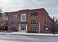
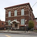
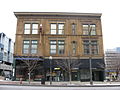
Below is a list of historic sites on High Street, from north to south. Historic districts are not included in this table, but are mentioned in § Historic districts. Buildings within historic districts, but no individual landmark designation, are not included in this table.

NameImageAddressCity or
neighborhood
CRHPNRHPNotes
Orange Johnson House Museum Buttles-Johnson House.jpg 956 High Street Worthington Yes
Worthington Presbyterian Church Worthington Presbyterian Church.jpg 773 High Street Worthington Yes
Demas Adams House Demas Adams House 8-3-08.jpg 721 High Street Worthington Yes
St. John's Episcopal Church St. John's Episcopal Church in Worthington.jpg 700 High Street Worthington Yes
Kilbourn Commercial Building Kilbourn Commercial Building.jpg 679-681 High Street Worthington Yes
Hotel Central Hotel Central, Worthington Inn.jpg 649 High Street Worthington Yes
New England Lodge New England Lodge in Worthington.jpg 634 High Street Worthington Yes
Doctor Longenecker Office Building Doctor Longenecker Office Building.jpg 633-635 High Street Worthington Yes
Ripley House Ripley House in Worthington.jpg 623 High Street Worthington Yes
Mark Russell House Mark Russell House.jpg 5751 N. High Street Riverlea Yes
Northmoor Engine House / Station #19 Northmoor Engine House, Clintonville.jpg 3601 N. High StreetNorthmoor
(Clintonville)
Yes
White Castle Restaurant White Castle, North High Street crop.jpg 2725 N. High Street University District Yes
1379 N. High Street Apartment Building 1379 N. High.jpg 1379 N. High Street University District Yes
York Lodge No. 563 Free & Accepted Masons.jpg 1276 N. High Street University District Yes
Union Station arcade Columbus Union Station arcade, June 1970.jpg 370-400 N. High Street Downtown YesDemolished in 1976, delisted in 1999
Columbia Larrimer Building Columbia Building, Columbus.jpg 161-167 N. High Street Downtown YesYes
Atlas Building Columbus-Atlas Building (OHPTC & COAF) - 6032788761.jpg 8 E. Long Street Downtown Yes
Citizens Savings & Trust Company Columbus-Citizens Building (OHPTC) - 11572317353.jpg 51 N. High Street Downtown YesAlso part of a national historic district
Ohio Statehouse Ohio Statehouse 03.jpg 1 Capitol Square Downtown YesYesAlso a National Historic Landmark
Ohio National Bank Ohio National Bank 02.jpg 167 S. High Street Downtown Yes
Great Southern Hotel and Theatre Great Southern, Columbus.jpg 310 S. High Street Downtown YesYesAlso part of a city and national historic district
Schlee-Kemmler Building Schlee-Kemmler Building.jpg 326 S. High Street Downtown YesYesAlso part of a city and national historic district
Krumm Residence Photo 975 South High JD Healy.jpg 975-979 S. High Street Brewery District YesYes
Dan's Drive-In Dan's Drive-In.jpg 1881 S. High Street Merion Village Yes

Historic districts

There are numerous historic districts through which High Street passes. Buildings in these districts with individual landmark designations are described in § Individual landmarks. From north to south, the districts are:

See also

Related Research Articles

<span class="mw-page-title-main">Columbus, Ohio</span> Capital and largest city of Ohio, United States

Columbus is the capital and most populous city of the U.S. state of Ohio. With a 2020 census population of 905,748, it is the 14th-most populous city in the U.S., the second-most populous city in the Midwest after Chicago, and the third-most populous U.S. state capital after Phoenix, Arizona and Austin, Texas. Columbus is the county seat of Franklin County; it also extends into Delaware and Fairfield counties. It is the core city of the Columbus metropolitan area, which encompasses ten counties in central Ohio. It had a population of 2,138,926 in 2020, making it the largest metropolitan area entirely in Ohio and 32nd-largest metro area in the U.S.

<span class="mw-page-title-main">German Village</span> Historic neighborhood in Columbus, Ohio, U.S.

German Village is a historic neighborhood in Columbus, Ohio, just south of the city's downtown. It was settled in the early-to-mid-19th century by a large number of German immigrants, who at one time comprised as much as a third of the city's entire population. It became a city historic district in 1960 and was added to the National Register of Historic Places in 1974, becoming the list's largest privately funded preservation district, and in 2007, was made a Preserve America Community by the federal government. In 1980, its boundaries increased, and today it is one of the world's premier historic restorations.

<span class="mw-page-title-main">U.S. Route 23</span> Highway in the United States

U.S. Route 23 or U.S. Highway 23 (US 23) is a major north–south United States Numbered Highway between Jacksonville, Florida, and Mackinaw City, Michigan. It is an original 1926 route which originally reached only as far south as Portsmouth, Ohio, and has since been extended. It was formerly part of the major highway known as the Dixie Highway. The highway's southern terminus is in Jacksonville, Florida, at US 1/US 17. The northern terminus is at Interstate 75 (I-75) in Mackinaw City, Michigan.

<span class="mw-page-title-main">Hilltop (Columbus, Ohio)</span> Neighborhood of Columbus in Franklin, Ohio, United States

Hilltop is one of the largest neighborhoods in Columbus, Ohio, located west of Franklinton and Downtown. The Greater Hilltop area contains newer and historic neighborhoods, schools, various stores, industrial areas, and recreational facilities. The development pattern is considered a distinct suburb. The majority of the area is predominantly single family residential.

<span class="mw-page-title-main">Franklinton (Columbus, Ohio)</span> Neighborhood in Columbus, Ohio

Franklinton is a neighborhood in Columbus, Ohio, just west of its downtown. Settled in 1797, Franklinton is the first American settlement in Franklin County, and was the county seat until 1824. As the city of Columbus grew, the city annexed and incorporated the existing settlement in 1859. Franklinton is bordered by the Scioto River on the north and east, Harmon Avenue on the east, Stimmel Road and Greenlawn Avenue on the south, and Interstate 70 on the west. Its main thoroughfare is West Broad Street, one of the city's two main roads.

<span class="mw-page-title-main">Italian Village</span> Neighborhood of Columbus in Franklin, Ohio, United States

Italian Village is a neighborhood in Columbus, Ohio, that contains an array of residential, commercial, and industrial buildings. It is a designated historic district, known for its historical and cultural preservation. The building types and architecture reflect Italian influence. With its parks and preserved historic homes, Italian Village has the highest home value appreciation in Columbus.

<span class="mw-page-title-main">Columbus metropolitan area, Ohio</span> Metropolitan statistical area in Ohio, United States

The Columbus, Ohio metropolitan area is a metropolitan area in Central Ohio surrounding the state capital of Columbus. As defined by the U.S. Census Bureau, it includes the counties of Delaware, Fairfield, Franklin, Hocking, Licking, Madison, Morrow, Perry, Pickaway, and Union. At the 2020 census, the MSA had a population of 2,138,926, making it 32nd-most populous in the United States and the second largest in Ohio, behind the Cincinnati metropolitan area. The metro area, also known as Central Ohio or Greater Columbus, is one of the largest and fastest-growing metropolitan areas in the Midwestern United States.

The Near East Side is a neighborhood located near downtown Columbus, Ohio, made up of several neighborhoods: Mount Vernon, King-Lincoln Bronzeville, Eastgate, Franklin Park, Nelson Park, Olde Towne East, and Woodland Park.

<span class="mw-page-title-main">Downtown Columbus, Ohio</span> Neighborhood in Columbus, Ohio

Downtown Columbus is the central business district of Columbus, Ohio. Downtown is centered on the intersection of Broad and High Streets, and encompasses all of the area inside the Inner Belt. Downtown is home to most of the tallest buildings in Columbus.

Columbus, the state capital and Ohio's largest city, has numerous neighborhoods within its city limits. Neighborhood names and boundaries are not officially defined. They may vary or change from time to time due to demographic and economic variables.

<span class="mw-page-title-main">Old North Columbus</span> Neighborhood in Columbus, Ohio

Old North Columbus is a neighborhood located just north of the Ohio State University in Columbus, Ohio. It was founded in 1847 where, at the time, it was a stand-alone city out of the confines of Columbus until it was incorporated into the City of Columbus in 1871. In its early years the city was a popular stagecoach stop with people traveling from Worthington to Columbus. Today Old North Columbus is popular for its local music and its unique "untouched architecture" which is reminiscent of its old roots.

<span class="mw-page-title-main">Geography of Columbus, Ohio</span> Topography, climate and cityscape in the city

The city of Columbus is located in central Ohio at the confluence of the Scioto and Olentangy rivers. The region is dominated by a humid continental climate, characterized by hot, muggy summers and cold, dry winters.

<span class="mw-page-title-main">Woodland Park (Columbus, Ohio)</span> Neighborhood of Columbus in Franklin, Ohio, United States

Woodland Park is a residential neighborhood located in the Near East Side of Columbus, Ohio that houses approximately 1,500 residents. The neighborhood was previously home to such figures as artist Emerson Burkhart, cartoonist Billy Ireland, and judge William Brooks. Established in the early 20th century, Woodland Park has grown from its planned neighborhood roots into a neighborhood that contains various faith communities, schools, sources of entertainment and recreation, and borders an extension of the Ohio State University medical center.

<span class="mw-page-title-main">Franklin Park (Columbus, Ohio)</span> Place

Franklin Park is a neighborhood located on the Near East Side of Columbus, Ohio. Both the historic neighborhood and landmark, the Franklin Park Conservatory and Botanical Gardens, are named after the 88-acre park.

Columbus, the capital city of Ohio, was founded on the east bank of the Scioto River in 1812. The city was founded as its capitol, beside the town of Franklinton, since incorporated into Columbus. The city's early history was gradual, as residents dealt with flooding and cholera epidemics, and the city had few direct connections to other cities. This led creation of a feeder canal, and later, freight and passenger railroads. The city became known for its industry and commercial businesses into the 20th century, though it experienced a lull in development in the late 20th century. In the 21st century, Columbus has been increasingly revitalized, led by parks projects, new developments, and efforts to beautify individual neighborhoods.

<span class="mw-page-title-main">Public transit in Columbus, Ohio</span> Overview of public transportation in Columbus, Ohio

Public transit has taken numerous forms in Columbus, the largest city and capital of Ohio. Transit has variously used passenger trains, horsecars, streetcars, interurbans, trolley coaches, and buses. Current service is through the Central Ohio Transit Authority's bus system, numerous intercity bus companies, and through bikeshare, rideshare, and electric scooter services.

<span class="mw-page-title-main">Columbus Civic Center (Ohio)</span> Civic center in downtown Columbus, Ohio

The Columbus Civic Center is a civic center, a collection of government buildings, museums, and open park space in Downtown Columbus, Ohio. The site is located along the Scioto Mile recreation area and historically was directly on the banks of the Scioto River.

<span class="mw-page-title-main">Broad Street (Columbus, Ohio)</span> East-west street in Columbus, Ohio

Broad Street is a major thoroughfare in Central Ohio, predominantly in Franklin County and Columbus. It stretches east from West Jefferson at Little Darby Creek to Pataskala. The street is considered one of Columbus's two main roads, along with High Street.

<span class="mw-page-title-main">Columbus Landmarks</span> Historic preservation foundation in Ohio

The Columbus Landmarks Foundation, known as Columbus Landmarks, is a nonprofit historic preservation organization in Columbus, Ohio. The foundation is best-known for its list of endangered sites in the city and its annual design award, given to buildings, landscapes, and other sites created or renovated in Columbus. It was established in 1977 as a project of the Junior League of Columbus, Ohio, following the demolition of the city's historic Union Station. It is headquartered at 57 Jefferson Avenue, a contributing structure in the Jefferson Avenue Historic District in Downtown Columbus.

References

  1. Google (July 7, 2020). "Overview map of Broad Street" (Map). Google Maps . Google. Retrieved July 7, 2020.
  2. 1 2 Elliott, Susannah (July 28, 2015). "What is the longest, continuously running street in Columbus?". The Columbus Dispatch. Retrieved May 21, 2020.
  3. "Broad Street Bungled Yet Again". Columbus Navigator. April 9, 2019.
  4. 1 2 3 "The Start of Broad and High". The Columbus Dispatch. October 14, 1962. p. 163. Retrieved October 23, 2021.
  5. Moore, Opha (1930). History of Franklin County Ohio. Topeka-Indianapolis: Historical Publishing Company. p. 127.
  6. Federal Writers' Project employees (1946). The Ohio Guide (3rd ed.). Oxford University Press. p. 246. ISBN   9781603540346 . Retrieved April 27, 2020.
  7. "How to List a Property". National Register of Historic Places (U.S. National Park Service). November 26, 2019. Retrieved December 22, 2019.
  8. "Eligibility". National Historic Landmarks (U.S. National Park Service). August 29, 2018. Retrieved December 22, 2019.