The National Register of Historic Places (NRHP) is the United States federal government's official list of sites, buildings, structures, districts, and objects deemed worthy of preservation for their historical significance or "great artistic value".
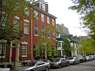
Washington Square West is a neighborhood in Center City, Philadelphia, Pennsylvania, United States. The neighborhood roughly corresponds to the area between 7th and Broad Streets and between Chestnut and South Streets, bordering on the Independence Mall tourist area directly northeast, Market East to the north, Old City and Society Hill to the East, Bella Vista directly south, Hawthorne to the southwest, and mid-town Philadelphia and Rittenhouse Square to the west. The area takes its name from Washington Square, a historic urban park in the northeastern corner of the neighborhood. In addition to being a desirable residential community, it is considered a hip, trendy neighborhood that offers a diverse array of shops, restaurants, and coffee houses. Washington Square West contains many gay-friendly establishments, especially in the gay village area of the neighborhood commonly known as the Gayborhood, which hosts annual events celebrating LGBT culture in Philadelphia, including OutFest.

Columbus Union Station was an intercity train station in Downtown Columbus, Ohio, near The Short North neighborhood. The station and its predecessors served railroad passengers in Columbus from 1851 until April 28, 1977.

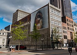
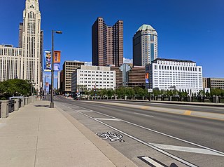
Downtown Columbus is the central business district of Columbus, Ohio. Downtown is centered on the intersection of Broad and High Streets, and encompasses all of the area inside the Inner Belt. Downtown is home to most of the tallest buildings in Columbus.

The Downtown Albany Historic District is a 19-block, 66.6-acre (27.0 ha) area of Albany, New York, United States, centered on the junction of State and North and South Pearl streets. It is the oldest settled area of the city, originally planned and settled in the 17th century, and the nucleus of its later development and expansion. In 1980 it was designated a historic district by the city and then listed on the National Register of Historic Places.

There are nine historic districts in Meridian, Mississippi. Each of these districts is listed on the National Register of Historic Places. One district, Meridian Downtown Historic District, is a combination of two older districts, Meridian Urban Center Historic District and Union Station Historic District. Many architectural styles are present in the districts, most from the late 19th century and early 20th century, including Queen Anne, Colonial Revival, Italianate, Art Deco, Late Victorian, and Bungalow.

Frank L. Packard was a prominent architect in Ohio. Many of his works were under the firm Yost & Packard, a company co-owned by Joseph W. Yost.

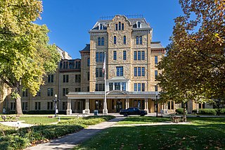
Broad Street Christian Church is a historic church building on the near east side of Columbus, Ohio, United States. The edifice was constructed in an exclusive residential neighborhood at the beginning of the twentieth century, and it has been designated a historic site. It was home for most of its history to a Disciples of Christ congregation, and is now the seat of an Ethiopian Orthodox congregation.

Richards, McCarty & Bulford was an American architectural firm. The General Services Administration has called the firm the "preeminent" architectural firm of the city of Columbus, Ohio. A number of the firm's works are listed on the National Register of Historic Places. The firm operated until 1943.
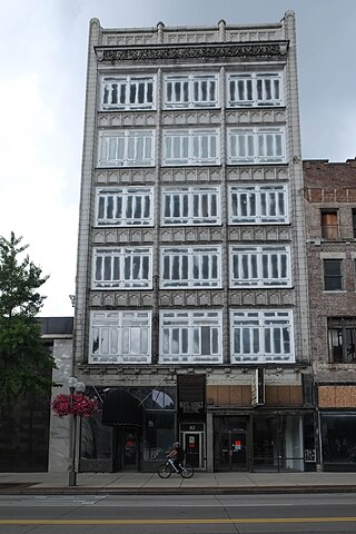
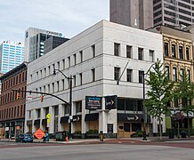
The White–Haines Building, also known as C. O. Haines Optical Company Building, is a historic building located at 82 North High Street in Downtown Columbus, Ohio. The building is part of the High and Gay Streets Historic District on the National Register of Historic Places.

Columbus City Hall is the city hall of Columbus, Ohio, in the city's downtown Civic Center. It contains the offices of the city's mayor, auditor, and treasurer, and the offices and chambers of Columbus City Council.

The Downtown Cheyenne Historic District in Cheyenne, Wyoming is a historic district that was listed on the National Register of Historic Places in 1978. It is an area of about seven blocks, in the core of the original business district of Cheyenne, and home of many of the first masonry commercial buildings in Cheyenne.

The Columbus Civic Center is a civic center, a collection of government buildings, museums, and open park space in Downtown Columbus, Ohio. The site is located along the Scioto Mile recreation area and historically was directly on the banks of the Scioto River.
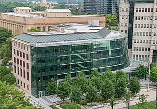
Columbus Public Health is the health department of Columbus, Ohio. The department is accredited by the Public Health Accreditation Board. The department dates to 1833, when the city's mayor appointed five citizens to help with its cholera outbreak. It became a permanent body to activate whenever health emergencies arose.
Broad Street is a major thoroughfare in Central Ohio, predominantly in Franklin County and Columbus. It stretches east from West Jefferson at Little Darby Creek to Pataskala. The street is considered one of Columbus's two main roads, along with High Street.

High Street is a major thoroughfare in Central Ohio, predominantly in Franklin County and Columbus. It stretches from the northern border of Columbus in Delaware County south to the southern boundary of Franklin County just past Columbus's municipal boundaries. The street is considered one of Columbus's two main roads, along with Broad Street.
77 North Front Street is a municipal office building of Columbus, Ohio, in the city's downtown Civic Center. The building, originally built as the Central Police Station in 1930, operated in that function until 1991. After about two decades of vacancy, the structure was renovated for city agency use in 2011.

The Trolley District is a mixed-use complex in Columbus, Ohio. The three-acre (1.2 ha) site houses the East Market, a public market and food hall, as well as two bars, restaurants, a brewery, and event space, with plans for neighboring apartments. The property is located in the city's Franklin Park neighborhood and is a contributing part of the Columbus Near East Side District, listed on the National Register of Historic Places.