National Register of Historic Places listings in Pike County, Ohio

Last updated
Location of Pike County in Ohio Map of Ohio highlighting Pike County.svg
Location of Pike County in Ohio

This is a list of the National Register of Historic Places listings in Pike County, Ohio.

Contents

It is intended to be a complete list of the properties and districts on the National Register of Historic Places in Pike County, Ohio, United States. The locations of National Register properties and districts for which the latitude and longitude coordinates are included below, may be seen in a Google map. [1]

National Register of Historic Places federal list of historic sites in the United States

The National Register of Historic Places (NRHP) is the United States federal government's official list of districts, sites, buildings, structures, and objects deemed worthy of preservation for their historical significance. A property listed in the National Register, or located within a National Register Historic District, may qualify for tax incentives derived from the total value of expenses incurred preserving the property.

Pike County, Ohio County in the United States

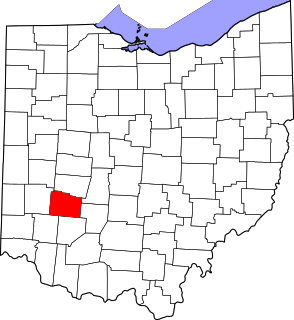
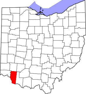
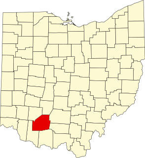
Pike County is a county located in the Appalachian region of the U.S. state of Ohio. As of the 2010 census, the population was 28,709. Its county seat is Waverly. The county is named for explorer Zebulon Pike.

Ohio State of the United States of America

Ohio is a Midwestern state in the Great Lakes region of the United States. Of the fifty states, it is the 34th largest by area, the seventh most populous, and the tenth most densely populated. The state's capital and largest city is Columbus.

There are 8 properties and districts listed on the National Register in the county.

This National Park Service list is complete through NPS recent listings posted June 1, 2018. [2]
Map all coordinates using: OpenStreetMap  ·  Google Maps
Download coordinates as: KML  ·  GPX

Current listings

[3] Name on the Register [4] ImageDate listed [5] Location City or townDescription
1 Eager Inn
Eager Inn Eager Inn.jpg
Eager Inn
November 8, 1974
(#74001597)
North of Morgantown off State Route 772
39°08′32″N83°11′45″W / 39.142222°N 83.195833°W / 39.142222; -83.195833 (Eager Inn)
Benton Township
2 Friendly Grove
Friendly Grove Friendly Grove.jpg
Friendly Grove
January 26, 1970
(#70000513)
State Route 220, east of Piketon
39°03′46″N82°58′16″W / 39.062778°N 82.971111°W / 39.062778; -82.971111 (Friendly Grove)
Seal Township
3 Jones-Cutler House
Jones-Cutler House Jones-Cutler House in color.jpg
Jones-Cutler House
April 26, 1976
(#76001509)
Bridge St. in Jasper
39°02′54″N83°03′13″W / 39.048472°N 83.053611°W / 39.048472; -83.053611 (Jones-Cutler House)
Newton Township
4 Piketon Historic District
Piketon Historic District Building in the Piketon Historic District.jpg
Piketon Historic District
February 28, 1974
(#74001598)
Bounded by West and 3rd Sts., U.S. Route 23, and the Scioto River
39°04′09″N83°00′40″W / 39.069167°N 83.011111°W / 39.069167; -83.011111 (Piketon Historic District)
Piketon
5 Piketon Mounds
Piketon Mounds Piketon Mounds.jpg
Piketon Mounds
May 2, 1974
(#74001599)
Mound Cemetery, south of Piketon [6]
39°03′04″N83°01′10″W / 39.051111°N 83.019444°W / 39.051111; -83.019444 (Piketon Mounds)
Seal Township
6 Scioto Township Works I
Scioto Township Works I Scioto Township Works from US23.jpg
Scioto Township Works I
October 9, 1974
(#74001600)
1 mile west of the Scioto River, north of Wakefield [7]
38°59′47″N83°01′37″W / 38.996389°N 83.026944°W / 38.996389; -83.026944 (Scioto Township Works I)
Scioto Township
7 Vanmeter Stone House and Outbuildings
Vanmeter Stone House and Outbuildings Vanmeter Stone House.jpg
Vanmeter Stone House and Outbuildings
March 31, 1975
(#75001519)
South of Piketon at the junction of U.S. Route 23 and State Route 124
39°02′39″N83°01′47″W / 39.044167°N 83.029722°W / 39.044167; -83.029722 (Vanmeter Stone House and Outbuildings)
Scioto Township
8 Waverly Canal Historic District
Waverly Canal Historic District Pike County Courthouse in Waverly.jpg
Waverly Canal Historic District
December 20, 1978
(#78002182)
Walnut, North, Emmitt (U.S. Route 23), 2nd, 3rd, and 4th Sts. between Lock and East
39°07′38″N82°59′01″W / 39.127222°N 82.983611°W / 39.127222; -82.983611 (Waverly Canal Historic District)
Waverly

See also

National Register of Historic Places listings in Ohio Wikimedia list article

This is a list of properties and districts in Ohio that are listed on the National Register of Historic Places. There are over 3,900 in total. Of these, 73 are National Historic Landmarks. There are listings in each of Ohio's 88 counties.

Related Research Articles

National Register of Historic Places listings in Cuyahoga County, Ohio Wikimedia list article

This is a list of the National Register of Historic Places listings in Cuyahoga County, Ohio.

National Register of Historic Places listings in Hamilton County, Ohio Wikimedia list article

This is a list of the National Register of Historic Places listings in Hamilton County, Ohio.

National Register of Historic Places listings in Montgomery County, Ohio Wikimedia list article

This is a list of the National Register of Historic Places listings in Montgomery County, Ohio.

National Register of Historic Places listings in Delaware County, Ohio Wikimedia list article

This is a list of the National Register of Historic Places listings in Delaware County, Ohio.

National Register of Historic Places listings in Fairfield County, Ohio Wikimedia list article

This is a list of the National Register of Historic Places listings in Fairfield County, Ohio.

National Register of Historic Places listings in Warren County, Ohio Wikimedia list article

This is a list of the National Register of Historic Places listings in Warren County, Ohio.

National Register of Historic Places listings in Ashtabula County, Ohio Wikimedia list article

This is a list of the National Register of Historic Places listings in Ashtabula County, Ohio.

National Register of Historic Places listings in Greene County, Ohio Wikimedia list article

This is a list of the National Register of Historic Places listings in Greene County, Ohio.

National Register of Historic Places listings in Muskingum County, Ohio Wikimedia list article

This is a list of the National Register of Historic Places listings in Muskingum County, Ohio.

National Register of Historic Places listings in Clark County, Ohio Wikimedia list article

This is a list of the National Register of Historic Places listings in Clark County, Ohio.

National Register of Historic Places listings in Ross County, Ohio Wikimedia list article

This is a list of the National Register of Historic Places listings in Ross County, Ohio.

National Register of Historic Places listings in Scioto County, Ohio Wikimedia list article

This is a list of the National Register of Historic Places listings in Scioto County, Ohio.

National Register of Historic Places listings in Athens County, Ohio Wikimedia list article

This is a list of the National Register of Historic Places listings in Athens County, Ohio.

National Register of Historic Places listings in Clermont County, Ohio Wikimedia list article

This is a list of the National Register of Historic Places listings in Clermont County, Ohio.

National Register of Historic Places listings in Pickaway County, Ohio Wikimedia list article

This is a list of the National Register of Historic Places listings in Pickaway County, Ohio.

National Register of Historic Places listings in Highland County, Ohio Wikimedia list article

This is a list of the National Register of Historic Places listings in Highland County, Ohio.

National Register of Historic Places listings in Hocking County, Ohio Wikimedia list article

This is a list of the National Register of Historic Places listings in Hocking County, Ohio.

National Register of Historic Places listings in Pike County, Indiana Wikimedia list article

This is a list of the National Register of Historic Places listings in Pike County, Indiana.

National Register of Historic Places listings in Fulton County, Ohio Wikimedia list article

This is a list of the National Register of Historic Places listings in Fulton County, Ohio.

This is a list of the National Register of Historic Places listings in western Cincinnati, Ohio.

References

  1. The latitude and longitude information provided in this table was derived originally from the National Register Information System, which has been found to be fairly accurate for about 99% of listings. For about 1% of NRIS original coordinates, experience has shown that one or both coordinates are typos or otherwise extremely far off; some corrections may have been made. A more subtle problem causes many locations to be off by up to 150 yards, depending on location in the country: most NRIS coordinates were derived from tracing out latitude and longitudes off of USGS topographical quadrant maps created under the North American Datum of 1927 , which differs from the current, highly accurate WGS84 GPS system used by most on-line maps. Chicago is about right, but NRIS longitudes in Washington are higher by about 4.5 seconds, and are lower by about 2.0 seconds in Maine. Latitudes differ by about 1.0 second in Florida. Some locations in this table may have been corrected to current GPS standards.
  2. "National Register of Historic Places: Weekly List Actions". National Park Service, United States Department of the Interior. Retrieved on June 1, 2018.
  3. Numbers represent an ordering by significant words. Various colorings, defined here, differentiate National Historic Landmarks and historic districts from other NRHP buildings, structures, sites or objects.
  4. National Park Service (2008-04-24). "National Register Information System". National Register of Historic Places . National Park Service.
  5. The eight-digit number below each date is the number assigned to each location in the National Register Information System database, which can be viewed by clicking the number.
  6. Location derived from this Ohio Historical Society webpage, and coordinates derived from the cemetery's GNIS feature record; the NRIS lists the site as "Address Restricted".
  7. Location derived from Mills, William C. Archeological Atlas of Ohio. Columbus: Ohio State Archeological and Historical Society, 1914, page 66 and plate 66. The NRIS lists the site as "Address Restricted".