Hamilton County was organized in 1790 by order of Arthur St. Clair, governor of the Northwest Territory, as the second county in the Northwest Territory. Cincinnati was named as the seat. Residents named the county in honor of Alexander Hamilton, who was the first Secretary of the Treasury of the United States and a founder of the Federalist Party. Its original boundaries were those defined for the Symmes purchase contract in 1788:[5] the Ohio River in the South, Great Miami River to the west, the Lesser Miami River to the east, and the Cuyahoga River to the North. Its area then included about one-eighth of Ohio and had about 2,000 inhabitants (not including the remaining Native Americans).
The county was greatly expanded in 1792 to include what is today the lower peninsula of Michigan. Since 1796, other counties were created from Hamilton, reducing the county to its present size. The county was the location of much of the Northwest Indian War before and after its organization.
The United States forcibly removed most of the Shawnee and other Indian peoples to move to locations west of the Mississippi River in the 1820s.
Rapid growth occurred during the 1830s and 1840s as the area attracted many German and Irish immigrants, especially after the Great Famine in Ireland and the revolutions in Germany in 1848.
According to the U.S. Census Bureau, the county has a total area of 413 square miles (1,070km2), of which 406 square miles (1,050km2) is land and 6.7 square miles (17km2) (1.6%) is water.[6]
Cincinnati, Ohio viewed from the SW, across the Ohio River, in Kentucky
The county lies in a region of gentle hills formed by the slopes of the Ohio River valley and its tributaries. The Great Miami River, the Little Miami River, and the Mill Creek also contribute to this system of hillsides and valleys. No naturally occurring lakes exist, but three major humanmade lakes are part of the Great Parks of Hamilton County.[7] The largest lake by far is Winton Woods Lake, covering 188 surface acres, followed by Miami Whitewater Lake, covering 85 surface acres, and Sharon Lake, covering 36 surface acres.
The county boundaries include the lowest point in Ohio, in Miami Township, where the Ohio River flows out of Ohio and into Indiana. This is the upper pool elevation behind the Markland Dam, 455 feet (139m) above sea level.[8]
As of the 2020 census, the county had 830,639 residents, which yielded a population density of 2,045.91 people per square mile (791.08/km2). The median age was 36.9 years, with 22.3% of residents under the age of 18 and 16.2% aged 65 or older; for every 100 females there were 93.6 males, and for every 100 females age 18 and over there were 90.9 males.[9]
There were 347,126 households in the county, of which 27.4% had children under the age of 18 living in them. Of all households, 37.9% were married-couple households, 21.7% were households with a male householder and no spouse or partner present, and 33.3% were households with a female householder and no spouse or partner present. About 34.6% of all households were made up of individuals and 11.8% had someone living alone who was 65 years of age or older. The county had 379,015 housing units, 8.4% of which were vacant; of the occupied units, 57.4% were owner-occupied and 42.6% were renter-occupied, and the homeowner and rental vacancy rates were 1.4% and 8.6%, respectively.[9]
97.6% of residents lived in urban areas, while 2.4% lived in rural areas.[11]
Racial and ethnic composition
Hamilton County, Ohio – racial and ethnic composition Note: the US Census treats Hispanic/Latino as an ethnic category. This table excludes Latinos from the racial categories and assigns them to a separate category. Hispanics/Latinos may be of any race.
According to the U.S. Census American Community Survey, for the period 2016-2020 the estimated median annual income for a household in the county was $66,878, and the median income for a family was $92,480. About 15.3% of the population were living below the poverty line, including 17.6% of those under age 18 and 10.8% of those age 65 or over. About 64.1% of the population were employed, and 41.8% had a bachelor's degree or higher.[21]
2010 census
As of the 2010 census, there were 802,374 people, 333,945 households, and 197,571 families living in the county.[22] The population density was 1,976.7 inhabitants per square mile (763.2/km2). There were 377,364 housing units at an average density of 929.7 per square mile (359.0/km2).[23] The racial makeup of the county was 68.8% white, 25.7% black or African American, 2.0% Asian, 0.2% American Indian, 0.1% Pacific islander, 1.1% from other races, and 2.1% from two or more races. Those of Hispanic or Latino origin made up 2.6% of the population.[22] In terms of ancestry, 31.0% were German, 14.7% were Irish, 7.7% were English, and 6.6% were American.[24]
Of the 333,945 households, 29.7% had children under the age of 18 living with them, 39.4% were married couples living together, 15.4% had a female householder with no husband present, 40.8% were non-families, and 33.9% of all households were made up of individuals. The average household size was 2.34 and the average family size was 3.04. The median age was 37.1 years.[22]
The median income for a household in the county was $48,234 and the median income for a family was $64,683. Males had a median income of $48,344 versus $37,310 for females. The per capita income for the county was $28,799. About 11.1% of families and 15.4% of the population were below the poverty line, including 22.9% of those under age 18 and 9.0% of those age 65 or over.[25]
2000 census
As of the 2000 census, there were 845,303 people, 346,790 households, and 212,582 families living in the county. The population density was 2,075 inhabitants per square mile (801/km2). There were 373,393 housing units at an average density of 917 per square mile (354/km2). The racial makeup of the county was 69.2% White, 26.0% Black or African American, 0.1% Native American, 2.3% Asian, 0.01% Pacific Islander, 0.51% from other races, and 2.2% from two or more races. 2.8% of the population were Hispanic or Latino of any race.
There were 346,790 households, out of which 30.20% had children under the age of 18 living with them, 43.40% were married couples living together, 14.30% had a female householder with no husband present, and 38.70% were non-families. 32.90% of all households were made up of individuals, and 10.60% had someone living alone who was 65 years of age or older. The average household size was 2.38 and the average family size was 3.07.
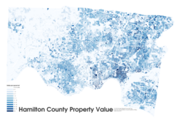
Hamilton County property value, dollars per square foot in 2011
In the county, the population was spread out, with 25.80% under the age of 18, 9.60% from 18 to 24, 29.70% from 25 to 44, 21.50% from 45 to 64, and 13.50% who were 65 years of age or older. The median age was 36 years. For every 100 females there were 91.10 males. For every 100 females age 18 and over, there were 86.80 males.
The median income for a household in the county was $40,964, and the median income for a family was $53,449. Males had a median income of $39,842 versus $28,550 for females. The per capita income for the county was $24,053. About 8.80% of families and 11.80% of the population were below the poverty line, including 16.20% of those under age 18 and 8.70% of those age 65 or over.
Population
The county's highest population was recorded in the 1970 U.S. Census. Since then, the county has lost population at an average rate of three percent per decade. Although Hamilton County is experiencing a decline in birth rates and has higher death rates in older age groups (cohorts), out-migration of residents is the key factor in population loss. In the last decade, this population loss has been reversed, and it is estimated that both Hamilton County and the City of Cincinnati have grown their populations.[26] The Cincinnati Metropolitan Statistical Area, over the last three decades has seen a 19 percent increase in population. Much of the region's growth has been through movement of Cincinnati and Hamilton County residents into neighboring counties.[26]
Since 1963, the Board has employed an administrator to run the day-to-day operations of the county; the current administrator is Jeffrey Aluotto.[28] Other elected officers include Dusty Rhodes (Auditor), Connie Pillich (Prosecutor), Charmaine McGuffey (Sheriff), Eric Beck (Engineer), Scott Crowley (Recorder), Jill Schiller (Treasurer), and Lakshmi Sammarco (Coroner).[28]
As of 2021, the elected Common Pleas Court include Judge Jody Luebbers, Judge Lisa Allen, Judge Jennifer Branch, Judge Wende Cross, Judge Leslie Ghiz, Judge Robert Goering, Judge Tom Heekin, Judge Christian Jenkins, Judge Charles Kubicki, Judge Melba Marsh, Judge Terry Nestor, Judge Robert Ruehlman, Judge Nicole Sanders, Judge Megan Shanahan, Judge Alan Triggs, and Judge Christopher Wagner.[29]
Politics
Hamilton County was historically rather conservative for an urban county. It long favored Republican candidates in national elections, but has trended Democratic in recent years. In 2008, Barack Obama was the first Democratic presidential candidate to win the county since 1964, and only the second since 1936. The county continued to lean Democratic, voting for Obama again in 2012 and for Democratic candidate Hillary Clinton in 2016. In fact, it was one of the few counties in Ohio to swing toward the Democrats in 2016 even as the state as a whole swung toward the Republicans.
In other state elections, the county also tended to favor Republican candidates. Richard Cordray in his failed 2018 bid was the first Democrat to win the county in a gubernatorial election since Dick Celeste in 1982, and only the second since Michael DiSalle in 1958.[30][31] In Senate elections, the county also tended to back Republicans, but has been won by Frank Lausche in 1962, John Glenn in all four of his elections and Howard Metzenbaum and Sherrod Brown in two out of three elections for both (1982 and 1988, and 2012 and 2018).[32] In the 2006 Ohio elections, both Ted Strickland and Sherrod Brown lost the county by less than 2,000 votes while winning statewide by 24 and 12 points, respectively.
With the election of Democrat Stephanie Summerow Dumas in 2018 midterm elections, the Hamilton County Board of Commissioners was entirely Democratic for the first time ever.[33] Democrats had previously regained majority control of the Board of Commissioners in 2016 with the election of Denise Driehaus. In 2019, longtime Democratic Commissioner Todd Portune announced his resignation from the Board due to health problems. Portune's chief of staff, Victoria Parks, was appointed to serve the remainder of his term (through the November 2020 general election). With Parks' appointment, the Board of Commissioners became for the first time all-female and majority Black.[34] In the November 2020 election, Democrat Alicia Reece was elected to fill Parks' seat, thereby retaining the Board's status as all-female and majority Black.[27]
Historically, due to its tight races and its position in the swing state of Ohio, Hamilton County was regarded as a crucial county to win in presidential elections. In 2012, The Washington Post named Hamilton as one of the seven most important counties in the country for that year's election.[35]Time characterized Hamilton County's political scene as "a battle between conservative suburbs and a Democratic urban center, though Cincinnati is one of the most conservative metro areas in the Midwest."[36] Those characterizations became less true in recent years. While many of Cincinnati's western suburbs, like Green and Delhi Townships, continue to strongly support Republican candidates, the city itself and most of its northern suburbs vote strongly Democratic.
United States presidential election results for Hamilton County, Ohio[37]
In 2016, Cincinnati Public Schools had 35,000 students, 63% of which were African-American.[41] The county also has a vocational school district, the Great Oaks Institute of Technology and Career Development. Parochial schools of various denominations add to this base. Among these the Roman Catholic Archdiocese of Cincinnati maintains a system of 108 elementary and 22 secondary schools, the ninth largest private school system in the United States.
Colleges and universities
The University of Cincinnati was founded in 1819; the Engineering Research Center, designed by UC Alumnus Michael Graves, was designed to look like a 4-cylinder engine.
Major sports teams are listed under the communities in which they are located, primarily Cincinnati.
The Great Parks of Hamilton County district resides within Hamilton County, and maintains a series of preserves and educational facilities. Three of the largest parks in the system are Miami Whitewater Forest, Winton Woods, and Sharon Woods.
The following list includes townships that have existed within present-day Hamilton County, including those that no longer exist or remain only as paper townships. It does not include townships that became part of Butler, Warren, Clermont, Montgomery, and other counties.
This page is based on this Wikipedia article Text is available under the CC BY-SA 4.0 license; additional terms may apply. Images, videos and audio are available under their respective licenses.