Finneytown, Ohio

Last updated

Finneytown, Ohio
CDP
Finneytown residential area.jpg
Residential area in Finneytown
Hamilton County Ohio Incorporated and Unincorporated areas Finneytown highlighted.svg
Location in Hamilton County and the state of Ohio
Coordinates: 39°12′49″N84°30′00″W / 39.21361°N 84.50000°W / 39.21361; -84.50000
Country United States
State Ohio
County Hamilton
Area
[1]
  Total3.99 sq mi (10.32 km2)
  Land3.99 sq mi (10.32 km2)
  Water0.00 sq mi (0.00 km2)
Elevation
[2]
840 ft (260 m)
Population
 (2020)
  Total12,399
  Density3,110.64/sq mi (1,201.00/km2)
Time zone UTC-5 (Eastern (EST))
  Summer (DST) UTC-4 (EDT)
ZIP codes
45224, 45231
Area code 513
FIPS code 39-27104 [3]
GNIS feature ID2392997 [2]

Finneytown is a census-designated place (CDP) in Springfield Township, Hamilton County, in southwest Ohio, United States, just north of Cincinnati. The population was 12,399 at the 2020 census. Finneytown is home to the second largest private school in Ohio (St. Xavier High School) and the Cincinnati area's annual Greek Festival (at Holy Trinity-St. Nicholas Greek Orthodox Church). [4]

Contents

Finneytown is named for Ebenezer Ward Finney, a Revolutionary War soldier whose burial site is located just south of the current township. [5] The land was originally purchased from John Cleves Symmes by Rev. Ebenezer Ward, and given to his grandson Ebenezer Ward Finney. [6]

History

Founding

In April 1795, an old preacher named Reverend Ebenezer Ward bought the section of land which included modern day Finneytown from John Cleves Symmes. Ebenezer Ward became ill and wrote a will which designated the land to be inherited by his grandson, Ebenezer Ward Finney (born 1755). At the time the 41-year-old Finney was living in Rensselaer County, New York and had served in the 4th New York Regiment during the American Revolutionary War. Once he learned about his inheritance of Rev. Ward's land, Finney traveled to Finneytown to inspect the land. Finneytown at the time was sparsely populated and had one trail that went East-West, known at the time as The North Bend to Carthage Trace (modern day Northbend Road) and an Indian trail that went North-South. Finney sold his old farm and moved into Finneytown with his family in 1800. He set up his farmstead on a hilltop location near the North Bend road and the road to Winton's Plantation, and he also donated a plot of his land for a small church. Ebenezer Ward Finney died in 1822 at the age of 67. One of the original pioneers, Samuel Raymond, moved to Finney's land and built a blacksmith shop, which remained until the 20th century. [5] [7]

Suburbanization

In the 20th century, Finneytown experienced growth as it transitioned from a rural area to a suburb. 1905 saw the founding of Special District School #10 to meet the demand for education, which was finished in 1915. Additionally, the early 20th century saw the introduction of automobiles to Finneytown, which resulted in the paving of the area's dirt roads. Winton Road, one of the area's main streets, was among the first to be paved in 1926.

After the Second World War, Finneytown saw a population boom as the school age population increased by 368% between 1948 and 1958. Farms were replaced by suburban housing and shopping centers. This population growth occurred at the same time a requirement for K-12 programs was introduced, which led to the founding of the Finneytown Secondary Campus in 1958. This was followed by the construction of Cottonwood Elementary in 1962 and Brent Elementary in 1964. In 2010, Cottonwood Elementary was demolished due to the difficulty of maintenance, and a new elementary school, Finneytown Elementary, was built in 2022 to replace Brent. [8] [7] [9] [10]

Geography

According to the United States Census Bureau, the CDP has a total area of 4.0 square miles (10 km2), all land.

Demographics

Historical population
CensusPop.Note
2020 12,399
U.S. Decennial Census [11]

2020 census

As of the census of 2020, there were 12,399 people living in the CDP, for a population density of 3,110.64 people per square mile (1,201.00/km2). There were 5,105 housing units. The racial makeup of the CDP was 50.4% White, 37.1% Black or African American, 0.3% Native American, 4.8% Asian, 0.0% Pacific Islander, 1.6% from some other race, and 5.8% from two or more races. 2.9% of the population were Hispanic or Latino of any race. [12]

There were 5,346 households, out of which 29.3% had children under the age of 18 living with them, 48.3% were married couples living together, 14.6% had a male householder with no spouse present, and 31.0% had a female householder with no spouse present. 26.5% of all households were made up of individuals, and 9.1% were someone living alone who was 65 years of age or older. The average household size was 2.48, and the average family size was 2.95. [12]

21.1% of the CDP's population were under the age of 18, 61.2% were 18 to 64, and 17.7% were 65 years of age or older. The median age was 47.2. For every 100 females, there were 93.5 males. [12]

According to the U.S. Census American Community Survey, for the period 2016-2020 the estimated median annual income for a household in the CDP was $73,196, and the median income for a family was $75,196. About 7.4% of the population were living below the poverty line, including 17.4% of those under age 18 and 2.9% of those age 65 or over. About 62.5% of the population were employed, and 35.1% had a bachelor's degree or higher. [12]

2010 census

The population was 12,741 at the U.S. 2010 census, in 5,294 housing units. The racial makeup of the CDP was 61.7% White, 33.7% Black, 1.9% Hispanic, with others 1% or less. [13]

2000 census

As of the census [3] of 2000, there were 13,492 people, 5,194 households, and 3,807 families residing in the CDP. The population density was 3,382.8 inhabitants per square mile (1,306.1/km2). There were 5,336 housing units at an average density of 1,337.9/sq mi (516.4/km2). The racial makeup was 72.95% White, 23.83% African American, 0.16% Native American, 1.10% Asian, 0.01% Pacific Islander, 0.45% from other races, and 1.48% from two or more races. Hispanic or Latino of any race were 0.80% of the population.

There were 5,194 households, out of which 34.6% had children under the age of 18 living with them, 55.7% were married couples living together, 14.6% had a female householder with no husband present, and 26.7% were non-families. 23.9% of all households were made up of individuals, and 10.7% had someone living alone who was 65 years of age or older. The average household size was 2.57 and the average family size was 3.04.

In the CDP, the population was spread out, with 27.6% under the age of 18, 6.1% from 18 to 24, 26.3% from 25 to 44, 22.9% from 45 to 64, and 17.1% who were 65 years of age or older. The median age was 38 years. For every 100 females, there were 87.9 males. For every 100 females age 18 and over, there were 80.3 males.

The median income for a household in the CDP was $52,219, and the median income for a family had been $58,393. Males had a median income of $41,932 versus $31,250 for females. The per capita income for the CDP was $25,355. About 4.3% of families and 5.9% of the population were below the poverty line, including 7.5% of those under age 18 and 4.1% of those age 65 or over.

Culture

Panegyri Greek Festival in 2008 Panegyri greek festival Cincinnati.jpg
Panegyri Greek Festival in 2008

Finneytown is the home of the annual Panegyri Greek Festival, [14] one of the largest annual ethnic food celebrations in the Cincinnati area. [15] The Holy Trinity-Saint Nicholas Greek Orthodox Church started the yearly festival in 1975. It has included authentic Greek food, music, dancing, and an art show. The festival has been held in June in recent years.

Education

Public School District

The Finneytown Local School District serves the neighborhood and surrounding area. The district has 2 schools that are divided by grades. [16] They include: Finneytown Elementary (K-6) and the Junior/Senior High or Secondary Campus (7-12). [16]

Private Schools

There are four private schools within Finneytown:

As of 2016, St. Xavier is the largest private school in Ohio. [17]

Finneytown is also home to the Cincinnati College of Mortuary Science. [18]

Notable people

Related Research Articles

<span class="mw-page-title-main">New Paris, Indiana</span> Census-designated place in Indiana, United States

New Paris is a census-designated place (CDP) in Elkhart County, Indiana, United States. The population was 1,494 at the 2010 census.

<span class="mw-page-title-main">Ross, Ohio</span> Census-designated place in Ohio, United States

Ross is a census-designated place (CDP) in Ross Township, Butler County, Ohio, United States. The population was 3,478 at the 2020 census. Ross sits along U.S. Route 27 between Cincinnati, Ohio and Oxford, Ohio. Ross is part of the Cincinnati metropolitan area.

<span class="mw-page-title-main">Grandview, Hamilton County, Ohio</span> Census-designated place in Ohio, United States

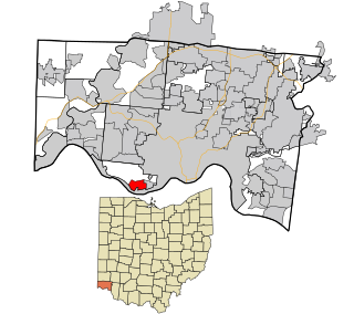
Grandview is a census-designated place (CDP) in Hamilton County, Ohio, United States. The population was 1,312 at the 2020 census.

<span class="mw-page-title-main">Groesbeck, Ohio</span> Census-designated place in Ohio, United States

Groesbeck is a census-designated place (CDP) in Hamilton County, Ohio, United States. The population was 7,365 at the 2020 census. It is a suburb of Cincinnati.

<span class="mw-page-title-main">Northgate, Ohio</span> Census-designated place in Ohio, United States

Northgate is a census-designated place (CDP) in Colerain Township, Hamilton County, Ohio, United States. The population was 7,277 at the 2020 census.

<span class="mw-page-title-main">Pleasant Run Farm, Ohio</span> Census-designated place in Ohio, United States

Pleasant Run Farm is a census-designated place (CDP) in Springfield Township, Hamilton County, Ohio, United States. The population was 4,779 at the 2020 census.

<span class="mw-page-title-main">White Oak, Ohio</span> Census-designated place in Ohio, United States

White Oak is a census-designated place (CDP) in Hamilton County, Ohio, United States. It is seven miles northwest of Cincinnati. The population was 19,541 at the 2020 census. White Oak is situated in both Green Township and Colerain Township.

<span class="mw-page-title-main">Devola, Ohio</span> CDP in Ohio, United States

Devola is a census-designated place (CDP) in Washington County, Ohio, United States, along the Muskingum River. It is part of the Parkersburg-Marietta-Vienna, WV-OH Metropolitan Statistical Area. The population was 2,639 at the 2020 census.

<span class="mw-page-title-main">Sharonville, Ohio</span> City in Ohio, United States

Sharonville is a city largely in Hamilton County in the U.S. state of Ohio. The population was 14,117 at the 2020 census.

<span class="mw-page-title-main">Green Township, Hamilton County, Ohio</span> Township in Ohio, United States

Green Township is one of the twelve townships of Hamilton County, Ohio, United States. It is a suburb of the neighboring city of Cincinnati. With a population of 60,424 at the 2020 census, Green Township is the most populous township in Hamilton County, and the second most populous township in Ohio. It was founded in 1809.

<span class="mw-page-title-main">Springfield Township, Hamilton County, Ohio</span> Township in Ohio, United States

Springfield Township is one of the twelve townships of Hamilton County, Ohio, United States. The population was 35,862 as of the 2020 census. Springfield Township is home to the largest private school in Ohio, the largest lake in Hamilton County, and the Cincinnati area's annual Greek Festival.

<span class="mw-page-title-main">Camp Dennison, Ohio</span> Census-designated place in Ohio, United States

Camp Dennison is a census-designated place (CDP) just outside Indian Hill in southern Symmes Township, Hamilton County, Ohio, United States. It has a post office with the ZIP code 45111. The population was 384 at the 2020 census.

<span class="mw-page-title-main">Mack, Ohio</span> Census-designated place in Ohio, United States

Mack is a census-designated place (CDP) in Green and Miami townships, Hamilton County, Ohio, United States. The population was 11,088 at the 2020 census. At prior censuses, the community was listed as two separate CDPs, Mack North and Mack South.

<span class="mw-page-title-main">Monfort Heights, Ohio</span> Census-designated place in Ohio, United States

Monfort Heights is a census-designated place (CDP) in Green Township, Hamilton County, Ohio, United States, part of the Cincinnati–Northern Kentucky metropolitan area. The population of Monfort Heights was 12,070 at the 2020 census. In previous censuses, the area was listed as two separate CDPs, Monfort Heights East and Monfort Heights South.

<span class="mw-page-title-main">Remington, Ohio</span> Census-designated place in Ohio, United States

Remington is a small hamlet and census-designated place (CDP) in Hamilton County, Ohio, United States. It is adjacent to Loveland, Indian Hill, and Camp Dennison and is considered part of the Greater Cincinnati area. It is included in the Indian Hill Exempted Village School District. The population of Remington was 368 at the 2020 census.

<span class="mw-page-title-main">Delhi Hills, Ohio</span> Census-designated place in Ohio, United States

Delhi Hills is a census-designated place (CDP) in Delhi Township, Hamilton County, Ohio, United States. The population was 5,022 at the 2020 census.

<span class="mw-page-title-main">Delshire, Ohio</span> Census-designated place in Ohio, United States

Delshire is a census-designated place (CDP) in Delhi Township, Hamilton County, Ohio, United States. The population was 3,158 at the 2020 census.

Pleasant Hills is a census-designated place (CDP) in Hamilton County, Ohio, United States. The population was 950 at the 2020 census.

<span class="mw-page-title-main">Rossmoyne, Ohio</span> Census-designated place in Ohio, United States

Rossmoyne is a census-designated place (CDP) in Sycamore Township, Hamilton County, Ohio, United States, 13 miles (21 km) northeast of downtown Cincinnati. The population of Rossmoyne was 1,788 at the 2020 census.

<span class="mw-page-title-main">Skyline Acres, Ohio</span> Census-designated place in Ohio, United States

Skyline Acres is a census-designated place (CDP) in Colerain and Springfield townships, Hamilton County, Ohio, United States. The population was 1,446 at the 2020 census.

References

  1. "ArcGIS REST Services Directory". United States Census Bureau. Retrieved September 20, 2022.
  2. 1 2 U.S. Geological Survey Geographic Names Information System: Finneytown, Ohio
  3. 1 2 "U.S. Census website". United States Census Bureau . Retrieved January 31, 2008.
  4. Campbell, Polly. "Maybe we should call it Greek chili". Cincinnati.com.
  5. 1 2 "Ebenezer Ward Finney - American Revolutionary War Veteran Graves on Waymarking.com". www.waymarking.com. Groundspeak. Retrieved April 3, 2023.
  6. "Finneytown history", Nuvox.net.
  7. 1 2 Bean, David. "History of Finneytown". Finneytown Local School District. Retrieved April 3, 2023.
  8. Noe, Terri. "History of Finneytown Schools". Finneytown Local School District. Retrieved April 3, 2023.
  9. Bean, Dave. "History of Springfield Township". www.springfieldtwp.org. Retrieved April 3, 2023.
  10. Mitchell, Madeline. "Finneytown schools unveils name of its newest building opening in spring 2022". The Enquirer. Cincinnati.com. Retrieved April 3, 2023.
  11. "Census of Population and Housing". Census.gov. Retrieved June 4, 2016.
  12. 1 2 3 4 "Finneytown CDP, Ohio - Census Bureau Profile". United States Census Bureau. Retrieved November 12, 2023.
  13. "Finneytown CDP Quickfacts from US Census Bureau", 2012, web:Cgov4.
  14. Smith, Steve; et al. (2007). "Arts & Attractions". Cincinnati USA City Guide. Cincinnati Magazine. p. 26. Retrieved May 6, 2013.
  15. Woellert, Dann (April 16, 2013). The Authentic History of Cincinnati Chili. The History Press. p. 13. ISBN   9781609499921 . Retrieved May 18, 2013.
  16. 1 2 "About Finneytown Local Schools", Finneytown.org, 2012, webpage: FTown-about.
  17. "Fall Enrollment (Headcount) - October 2016 Public Districts and Buildings" (Excel). Ohio Department of Education. April 18, 2016. Retrieved October 3, 2016. The table lists Westland High School as the 56th-largest public school building, with a headcount of 1,610. As discussed above, St. Xavier is the largest non-public school with an ADM of 1,610 students, putting it at number 56, safely within the top 100. Note that ODE does not report headcount for grades with 1–9 students; for each of these entries, nine students is assumed. ODE does not consider the headcount metric to be equivalent to ADM.
  18. "History - CCMS". Cincinnati College of Mortuary Science. Cincinnati College of Mortuary Science. Retrieved November 15, 2018.
  19. BF Pringles, PG.com, 2012.
  20. LOCAL 12 (May 5, 2015), "Goat" begins filming in local neighborhood, archived from the original on December 11, 2021, retrieved February 20, 2019{{citation}}: CS1 maint: numeric names: authors list (link)