Dunlap, Ohio

Last updated

Dunlap, Ohio
Hamilton County Ohio Incorporated and Unincorporated areas Dunlap highlighted.svg
Location in Hamilton County and the state of Ohio.
Coordinates: 39°17′26″N84°37′35″W / 39.29056°N 84.62639°W / 39.29056; -84.62639
Country United States
State Ohio
County Hamilton
Area
[1]
  Total6.66 sq mi (17.26 km2)
  Land6.53 sq mi (16.91 km2)
  Water0.13 sq mi (0.34 km2)
Elevation
[2]
653 ft (199 m)
Population
 (2020)
  Total1,658
  Density253.87/sq mi (98.02/km2)
Time zone UTC−5 (Eastern (EST))
  Summer (DST) UTC−4 (EDT)
FIPS code 39-22960 [3]
GNIS feature ID2585508 [2]

Dunlap is a census-designated place (CDP) in Colerain Township, Hamilton County, Ohio, United States. The population was 1,658 at the 2020 census. The siege of Dunlap's Station was a battle that took place near here on the Great Miami in 1791 during the Northwest Indian War.

Contents

History

A large part of Dunlap was originally owned by William and Asher Williamson. They sold their land in 1849 to a Mr. Parker[ who? ] who platted a number of lots along the Colerain Pike and Hamilton Road. In 1850, Oliver S. Glisson, an officer in the United States Navy, hired attorney Thomas S. Yeatman to lay out a subdivision south of the village on the farm of Glisson's recently deceased father. George Struble built several of the first houses in the village on his farmland east of the pike. The village was originally named Georgetown in his honor.

The first business established was a blacksmith shop. Asher Williamson kept the first store and George Struble the first hotel. The Dunlap post office, which had operated out of a cotton factory elsewhere in Colerain Township [ specify ], was moved to the village. As a result, Dunlap became the de facto name the village. By 1894, there were two churches, a schoolhouse, several stores and industries. [4] :384

Geography

Dunlap is located 15 miles (24 km) north of downtown Cincinnati. U.S. Route 27 runs through the eastern part of the CDP, and Colerain Avenue is the main road through the center of the community.

According to the United States Census Bureau, the CDP has a total area of 6.7 square miles (17.3 km2), of which 6.5 square miles (16.9 km2) is land and 0.15 square miles (0.4 km2), or 2.39%, is water. [5]

Demographics

As of the census of 2020, there were 1,658 people living in the CDP, for a population density of 253.87 people per square mile (98.02/km2). There were 695 housing units. The racial makeup of the CDP was 93.3% White, 1.6% Black or African American, 0.1% Native American, 0.5% Asian, 0.0% Pacific Islander, 0.4% from some other race, and 4.2% from two or more races. 1.0% of the population were Hispanic or Latino of any race. [6]

There were 559 households, out of which 25.4% had children under the age of 18 living with them, 74.1% were married couples living together, 18.2% had a male householder with no spouse present, and 6.3% had a female householder with no spouse present. 14.1% of all households were made up of individuals, and 5.9% were someone living alone who was 65 years of age or older. The average household size was 2.31, and the average family size was 2.51. [6]

13.3% of the CDP's population were under the age of 18, 63.8% were 18 to 64, and 22.9% were 65 years of age or older. The median age was 55.8. For every 100 females, there were 132.9 males. [6]

According to the U.S. Census American Community Survey, for the period 2016-2020 the estimated median annual income for a household in the CDP was $95,125, and the median income for a family was $113,125. About 14.4% of the population were living below the poverty line, including 27.5% of those under age 18 and 4.4% of those age 65 or over. About 56.2% of the population were employed, and 39.1% had a bachelor's degree or higher. [6]

Related Research Articles

<span class="mw-page-title-main">Ross, Ohio</span> Census-designated place in Ohio, United States

Ross is a census-designated place (CDP) in Ross Township, Butler County, Ohio, United States. The population was 3,478 at the 2020 census. Ross sits along U.S. Route 27 between Cincinnati, Ohio and Oxford, Ohio. Ross is part of the Cincinnati metropolitan area.

<span class="mw-page-title-main">Covedale, Ohio</span> Census-designated place in Ohio, United States

Covedale is a census-designated place (CDP) in Green Township, Hamilton County, Ohio, United States. The population was 6,472 at the 2020 census. The CDP represents the part of the former village of Covedale that was not annexed by the city of Cincinnati in 1930.

<span class="mw-page-title-main">Grandview, Hamilton County, Ohio</span> Census-designated place in Ohio, United States

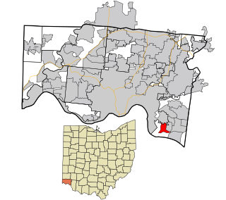
Grandview is a census-designated place (CDP) in Hamilton County, Ohio, United States. The population was 1,312 at the 2020 census.

<span class="mw-page-title-main">Groesbeck, Ohio</span> Census-designated place in Ohio, United States

Groesbeck is a census-designated place (CDP) in Hamilton County, Ohio, United States. The population was 7,365 at the 2020 census. It is a suburb of Cincinnati.

<span class="mw-page-title-main">Northgate, Ohio</span> Census-designated place in Ohio, United States

Northgate is a census-designated place (CDP) in Colerain Township, Hamilton County, Ohio, United States. The population was 7,277 at the 2020 census.

<span class="mw-page-title-main">Pleasant Run, Ohio</span> Census-designated place in Ohio, United States

Pleasant Run is a census-designated place (CDP) in Colerain Township, Hamilton County, Ohio, United States. The population was 4,861 at the 2020 census.

<span class="mw-page-title-main">Pleasant Run Farm, Ohio</span> Census-designated place in Ohio, United States

Pleasant Run Farm is a census-designated place (CDP) in Springfield Township, Hamilton County, Ohio, United States. The population was 4,779 at the 2020 census.

<span class="mw-page-title-main">White Oak, Ohio</span> Census-designated place in Ohio, United States

White Oak is a census-designated place (CDP) in Hamilton County, Ohio, United States. It is seven miles northwest of Cincinnati. The population was 19,541 at the 2020 census. White Oak is situated in both Green Township and Colerain Township.

<span class="mw-page-title-main">Colerain Township, Hamilton County, Ohio</span> Township in Ohio, United States

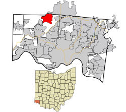
Colerain Township is one of the twelve townships of Hamilton County, Ohio, United States. The population of the township was 59,037 at the 2020 census. It is the second-largest township in Ohio by area, surpassed by Madison Township, Lake County, Ohio.

<span class="mw-page-title-main">Green Township, Hamilton County, Ohio</span> Township in Ohio, United States

Green Township is one of the twelve townships of Hamilton County, Ohio, United States. It is a suburb of the neighboring city of Cincinnati. With a population of 60,424 at the 2020 census, Green Township is the most populous township in Hamilton County, and the second most populous township in Ohio. It was founded in 1809.

<span class="mw-page-title-main">Miamitown, Ohio</span> Census-designated place in Ohio, United States

Miamitown is a census-designated place (CDP) in western Whitewater Township, Hamilton County, Ohio, United States. The population was 1,256 at the 2020 census. It has a post office with the ZIP code 45041.

<span class="mw-page-title-main">New Haven, Hamilton County, Ohio</span> Census-designated place in Ohio, United States

New Haven is a census-designated place (CDP) in Crosby Township, Hamilton County, Ohio, United States. The population was 572 at the 2020 census.

<span class="mw-page-title-main">Remington, Ohio</span> Census-designated place in Ohio, United States

Remington is a small hamlet and census-designated place (CDP) in Hamilton County, Ohio, United States. It is adjacent to Loveland, Indian Hill, and Camp Dennison and is considered part of the Greater Cincinnati area. It is included in the Indian Hill Exempted Village School District. The population of Remington was 368 at the 2020 census.

<span class="mw-page-title-main">Brecon, Ohio</span> Census-designated place in Ohio, United States

Brecon is a census-designated place (CDP) in Sycamore Township, Hamilton County, Ohio, United States. The population was 408 at the 2020 census.

<span class="mw-page-title-main">Dry Ridge, Ohio</span> Census-designated place in Ohio, United States

Dry Ridge is a census-designated place (CDP) in Colerain Township, Hamilton County, Ohio, United States. The population was 2,698 at the 2020 census.

<span class="mw-page-title-main">Salem Heights, Hamilton County, Ohio</span> Census-designated place in Ohio, United States

Salem Heights is a census-designated place (CDP) in Anderson Township, Hamilton County, Ohio, United States, adjacent to the city of Cincinnati. The population of Salem Heights was 3,862 at the 2020 census.

<span class="mw-page-title-main">Shawnee, Hamilton County, Ohio</span> Census-designated place in Ohio, United States

Shawnee is a census-designated place (CDP) in Miami Township, Hamilton County, Ohio, United States, 21 miles (34 km) west of downtown Cincinnati. The population of Shawnee was 747 at the 2020 census.

<span class="mw-page-title-main">Skyline Acres, Ohio</span> Census-designated place in Ohio, United States

Skyline Acres is a census-designated place (CDP) in Colerain and Springfield townships, Hamilton County, Ohio, United States. The population was 1,446 at the 2020 census.

<span class="mw-page-title-main">Taylor Creek, Ohio</span> Census-designated place in Ohio, United States

Taylor Creek is a census-designated place (CDP) in Colerain Township, Hamilton County, Ohio, United States. The population was 4,056 at the 2020 census.

Ridgewood is a census-designated place (CDP) in Hamilton County, Ohio, United States, adjacent to the city of Cincinnati. It was first listed as a CDP prior to the 2020 census. The population was 506 at the 2020 census.

References

  1. "ArcGIS REST Services Directory". United States Census Bureau. Retrieved September 20, 2022.
  2. 1 2 U.S. Geological Survey Geographic Names Information System: Dunlap, Ohio
  3. "U.S. Census website". United States Census Bureau . Retrieved January 31, 2008.
  4. History of Cincinnati and Hamilton County, Ohio. Cincinnati, Ohio: S. B. Nelson & Company, Publishers. 1894. p.  384.
  5. "Geographic Identifiers: 2010 Demographic Profile Data (G001): Dunlap CDP, Ohio". U.S. Census Bureau, American Factfinder. Archived from the original on February 12, 2020. Retrieved November 13, 2012.
  6. 1 2 3 4 "Dunlap CDP, Ohio - Census Bureau Profile". United States Census Bureau. Retrieved November 12, 2023.