Miamitown, Ohio

Last updated

Miamitown, Ohio
Miamitown.jpg
Whitewater Historical Society and Fire Station in Miamitown
Hamilton County Ohio Incorporated and Unincorporated areas Miamitown highlighted.svg
Location in Hamilton County and the state of Ohio
Coordinates: 39°13′01″N84°42′34″W / 39.21694°N 84.70944°W / 39.21694; -84.70944
Country United States
State Ohio
County Hamilton
Area
[1]
  Total1.37 sq mi (3.54 km2)
  Land1.34 sq mi (3.47 km2)
  Water0.03 sq mi (0.07 km2)
Elevation
[2]
682 ft (208 m)
Population
 (2020)
  Total1,256
  Density938.01/sq mi (362.14/km2)
Time zone UTC-5 (Eastern (EST))
  Summer (DST) UTC-4 (EDT)
ZIP code
45041
FIPS code 39-49462 [3]
GNIS feature ID2585514 [2]

Miamitown is a census-designated place (CDP) in western Whitewater Township, Hamilton County, Ohio, United States. The population was 1,256 at the 2020 census. It has a post office with the ZIP code 45041. [4]

Contents

History

Miamitown was founded in 1816 by Arthur Henry, who operated a flour mill and distillery. [5] The community was named after the nearby Great Miami River. [6]

Geography

Miamitown is located 16 miles (26 km) northwest of downtown Cincinnati. It is situated on the west bank of the Great Miami River at the intersection of Harrison Pike and Ohio State Route 128 (Hamilton Cleves Pike Road). Interstate 74 runs along the southern edge of the village, with access to it via Exit 7.

According to the United States Census Bureau, the CDP has a total area of 1.37 square miles (3.54 km2), of which 1.34 square miles (3.48 km2) is land and 0.023 square miles (0.06 km2), or 1.72%, is water. [7]

Demographics

As of the census of 2020, there were 1,256 people living in the CPD, for a population density of 938.01 people per square mile (362.14/km2). There were 655 housing units. The racial makeup of the CPD was 87.2% White, 3.1% Black or African American, 0.3% Native American, 0.2% Asian, 0.1% Pacific Islander, 2.1% from some other race, and 7.1% from two or more races. 4.1% of the population were Hispanic or Latino of any race. [8]

There were 607 households, out of which 21.9% had children under the age of 18 living with them, 7.9% were married couples living together, 39.4% had a male householder with no spouse present, and 28.5% had a female householder with no spouse present. 58.5% of all households were made up of individuals, and 28.6% were someone living alone who was 65 years of age or older. The average household size was 1.97, and the average family size was 4.04. [8]

22.6% of the CPD's population were under the age of 18, 62.8% were 18 to 64, and 14.6% were 65 years of age or older. The median age was 25.6. For every 100 females, there were 93.7 males. [8]

According to the U.S. Census American Community Survey, for the period 2016-2020 the estimated median annual income for a household in the CPD was $61,985. About 22.0% of the population were living below the poverty line, including 61.5% of those under age 18 and 0.0% of those age 65 or over. About 63.4% of the population were employed, and 12.7% had a bachelor's degree or higher. [8]

Related Research Articles

<span class="mw-page-title-main">Cherry Grove, Ohio</span> Census-designated place in Ohio, United States

Cherry Grove is a census-designated place (CDP) in Anderson Township, Hamilton County, Ohio, United States. The population was 4,419 at the 2020 census.

<span class="mw-page-title-main">Dry Run, Ohio</span> Census-designated place in Ohio, United States

Dry Run is a census-designated place (CDP) in Hamilton County, Ohio, United States. The population was 7,672 at the 2020 census.

<span class="mw-page-title-main">Fruit Hill, Ohio</span> Census-designated place in Ohio, United States

Fruit Hill is a census-designated place (CDP) in Hamilton County, Ohio, United States. The population was 3,748 at the 2020 census.

<span class="mw-page-title-main">Grandview, Hamilton County, Ohio</span> Census-designated place in Ohio, United States

Grandview is a census-designated place (CDP) in Hamilton County, Ohio, United States. The population was 1,312 at the 2020 census.

<span class="mw-page-title-main">Groesbeck, Ohio</span> Census-designated place in Ohio, United States

Groesbeck is a census-designated place (CDP) in Hamilton County, Ohio, United States. The population was 7,365 at the 2020 census. It is a suburb of Cincinnati.

<span class="mw-page-title-main">Mount Healthy Heights, Ohio</span> Census-designated place in Ohio, United States

Mount Healthy Heights is a census-designated place (CDP) in Hamilton County, Ohio, United States. The population was 2,918 at the 2020 census.

<span class="mw-page-title-main">White Oak, Ohio</span> Census-designated place in Ohio, United States

White Oak is a census-designated place (CDP) in Hamilton County, Ohio, United States. It is seven miles northwest of Cincinnati. The population was 19,541 at the 2020 census. White Oak is situated in both Green Township and Colerain Township.

<span class="mw-page-title-main">Hooven, Ohio</span> Census-designated place in Ohio, United States

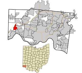
Hooven is a census-designated place (CDP) in southeastern Whitewater Township, Hamilton County, Ohio, United States. The population was 464 at the 2020 census.

<span class="mw-page-title-main">Camp Dennison, Ohio</span> Census-designated place in Ohio, United States

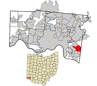
Camp Dennison is a census-designated place (CDP) just outside Indian Hill in southern Symmes Township, Hamilton County, Ohio, United States. It has a post office with the ZIP code 45111. The population was 384 at the 2020 census.

<span class="mw-page-title-main">Mack, Ohio</span> Census-designated place in Ohio, United States

Mack is a census-designated place (CDP) in Green and Miami townships, Hamilton County, Ohio, United States. The population was 11,088 at the 2020 census. At prior censuses, the community was listed as two separate CDPs, Mack North and Mack South.

<span class="mw-page-title-main">Dunlap, Ohio</span> Census-designated place in Ohio, United States

Dunlap is a census-designated place (CDP) in Colerain Township, Hamilton County, Ohio, United States. The population was 1,658 at the 2020 census. The siege of Dunlap's Station was a battle that took place near here on the Great Miami in 1791 during the Northwest Indian War.

<span class="mw-page-title-main">New Baltimore, Ohio</span> Census-designated place in Ohio, United States

New Baltimore is a census-designated place (CDP) in Crosby Township, Ohio. The population was 1,596 in the 2020 census.

<span class="mw-page-title-main">Blue Jay, Ohio</span> Census-designated place in Ohio, United States

Blue Jay is a census-designated place (CDP) in Whitewater Township, Hamilton County, Ohio, United States. The population was 1,427 at the 2020 census.

<span class="mw-page-title-main">Coldstream, Ohio</span> Census-designated place in Ohio, United States

Coldstream is a census-designated place (CDP) in southern Anderson Township, Hamilton County, Ohio, United States. The population was 1,322 at the 2020 census.

<span class="mw-page-title-main">Dry Ridge, Ohio</span> Census-designated place in Ohio, United States

Dry Ridge is a census-designated place (CDP) in Colerain Township, Hamilton County, Ohio, United States. The population was 2,698 at the 2020 census.

<span class="mw-page-title-main">Miami Heights, Ohio</span> Census-designated place in Ohio, United States

Miami Heights is a census-designated place (CDP) in Miami Township, Hamilton County, Ohio, United States. The population was 5,166 at the 2020 census.

Pleasant Hills is a census-designated place (CDP) in Hamilton County, Ohio, United States. The population was 950 at the 2020 census.

<span class="mw-page-title-main">Rossmoyne, Ohio</span> Census-designated place in Ohio, United States

Rossmoyne is a census-designated place (CDP) in Sycamore Township, Hamilton County, Ohio, United States, 13 miles (21 km) northeast of downtown Cincinnati. The population of Rossmoyne was 1,788 at the 2020 census.

<span class="mw-page-title-main">Sixteen Mile Stand, Ohio</span> Census-designated place in Ohio, United States

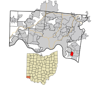
Sixteen Mile Stand is a census-designated place (CDP) in Symmes Township, Hamilton County, Ohio, United States, 19 miles (31 km) northeast of downtown Cincinnati. The population of Sixteen Mile Stand was 3,091 at the 2020 census.

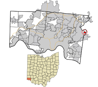
Ridgewood is a census-designated place (CDP) in Hamilton County, Ohio, United States, adjacent to the city of Cincinnati. It was first listed as a CDP prior to the 2020 census. The population was 506 at the 2020 census.

References

  1. "ArcGIS REST Services Directory". United States Census Bureau. Retrieved September 20, 2022.
  2. 1 2 U.S. Geological Survey Geographic Names Information System: Miamitown, Ohio
  3. "U.S. Census website". United States Census Bureau . Retrieved January 31, 2008.
  4. Zip Code Lookup
  5. Nelson, S. B. (1894). History of Cincinnati and Hamilton County, Ohio: Their Past and Present, Including...biographies and Portraits of Pioneers and Representative Citizens, etc., Volume 1. p. 460. Retrieved December 11, 2013.
  6. Overman, William Daniel (1958). Ohio Town Names. Akron, OH: Atlantic Press. p. 87.
  7. "Geographic Identifiers: 2010 Demographic Profile Data (G001): Miamitown CDP, Ohio". U.S. Census Bureau, American Factfinder. Archived from the original on February 12, 2020. Retrieved November 14, 2012.
  8. 1 2 3 4 "Miamitown CPD, Ohio - Census Bureau Profile". United States Census Bureau. Retrieved November 20, 2023.