Mignon is a census-designated place (CDP) in Talladega County, Alabama, United States. At the 2020 census, the population was 1,186.
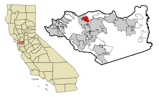
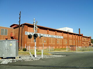
Vine Hill is a census-designated place (CDP) in Contra Costa County, California, United States. The population was 3,761 at the 2010 census. It is located 2.25 miles (3.6 km) east of downtown Martinez.

Sherwood Manor is a census-designated place (CDP) within the town of Enfield in Hartford County, Connecticut, United States. The population was 5,410 at the 2010 census.

Ocean City is a census-designated place (CDP) in Okaloosa County, Florida, United States. The population was 6,314 at the 2020 census, up from 5,550 at the 2010 census. It is part of the Crestview–Fort Walton Beach–Destin, Florida Metropolitan Statistical Area.

Beacon Square is a census-designated place (CDP) in Pasco County, Florida, United States. The population was 7,263 at the 2000 census.

Goddard is an unincorporated community and former census-designated place (CDP) in Prince George's County, Maryland, United States. It was named after the physicist Robert H. Goddard. The population was 5,554 in the 2000 census. The area was no longer a census-designated place as of the 2010 census.
Raynham Center is a census-designated place (CDP) in the town of Raynham in Bristol County, Massachusetts, United States. The population was 4,100 at the 2010 census.
Edgewater was a census-designated place (CDP) in Broward County, Florida, United States. The population was 803 at the 2000 census. It is now an incorporated neighborhood of Dania Beach.
Rockfish is a census-designated place (CDP) in Hoke County, North Carolina, United States. The population was 3,298 at the 2010 census, up from 2,353 at the 2000 census.

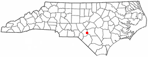
West Marion is a census-designated place (CDP) in McDowell County, North Carolina, United States, adjacent to the city of Marion, the county seat. The population was 1,348 at the 2010 census, down from 1,556 in 2000.

Covedale is a census-designated place (CDP) in Green Township, Hamilton County, Ohio, United States. The population was 6,472 at the 2020 census. The CDP represents the part of the former village of Covedale that was not annexed by the city of Cincinnati in 1930.
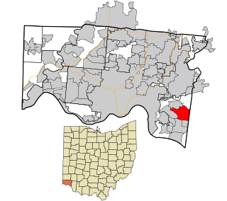
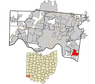
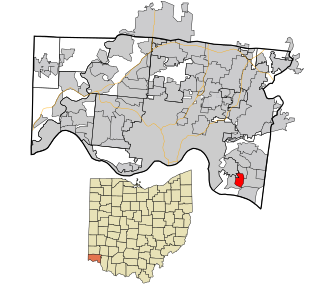
Dry Run is a census-designated place (CDP) in Anderson Township, Hamilton County, Ohio, United States. The population was 7,672 at the 2020 census.
Forestville is a census-designated place (CDP) in Anderson Township, Hamilton County, Ohio, United States. The population was 10,615 at the 2020 census.
Fruit Hill is a census-designated place (CDP) in Anderson Township, Hamilton County, Ohio, United States. The population was 3,748 at the 2020 census.

Mount Healthy Heights is a census-designated place (CDP) in Colerain Township, Hamilton County, Ohio, United States. The population was 2,918 at the 2020 census.

Northbrook is a census-designated place (CDP) in Colerain Township, Hamilton County, Ohio, United States. The population was 10,912 at the 2020 census.

Northgate is a census-designated place (CDP) in Colerain Township, Hamilton County, Ohio, United States. The population was 7,277 at the 2020 census.

Turpin Hills is a census-designated place (CDP) in Anderson Township, Hamilton County, Ohio, United States. The population was 5,162 at the 2020 census.

Tri-City is a census-designated place (CDP) and unincorporated community in Douglas County, Oregon, United States. The population was 3,931 at the 2010 census. The community in Missouri Bottom near the Umpqua River is named for the three cities among which it is centered: Myrtle Creek, Canyonville and Riddle. The Tri City School District probably originated the name, which was later adopted by the local sewer district and the former Tri City State Airport.

Loveland Park is a census-designated place (CDP) located in Symmes Township, Hamilton County and Deerfield Township, Warren County, in the southwestern part of the U.S. state of Ohio. The CDP is named after the city of Loveland. The population was 1,737 at the 2020 census.

