Amberley, Ohio

Last updated

Amberley Village, Ohio
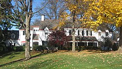
James Baxter House.jpg
James Baxter House, built 1807
Hamilton County Ohio Incorporated and Unincorporated areas Amberley highlighted.svg
Location in Hamilton County and the state of Ohio.
Coordinates: 39°12′13″N84°25′42″W / 39.20361°N 84.42833°W / 39.20361; -84.42833
Country United States
State Ohio
County Hamilton
Government
  MayorThomas Muething (R) [1]
Area
[2]
  Total3.48 sq mi (9.02 km2)
  Land3.48 sq mi (9.02 km2)
  Water0.00 sq mi (0.00 km2)
Elevation
[3]
801 ft (244 m)
Population
 (2020)
  Total3,840
  Density1,102.50/sq mi (425.68/km2)
Time zone UTC-5 (Eastern (EST))
  Summer (DST) UTC-4 (EDT)
ZIP Code
45237, 45213
Area code 513
FIPS code 39-01672 [4]
GNIS feature ID1086196 [3]
Website www.amberleyvillage.org

Amberley, locally known as Amberley Village, is a village in Hamilton County, Ohio, United States. The population was 3,840 at the 2020 census.

Contents

History

Amberley was incorporated as a village on April 5, 1940. The town was named after Amberley, a village in England. [5]

Amberley was designated a Tree City USA by the National Arbor Day Foundation in 2004. Amberley is home to French Park, owned by the city of Cincinnati.

Geography

According to the United States Census Bureau, the village has a total area of 3.50 square miles (9.06 km2), all land. [6]

Demographics

Historical population
CensusPop.Note
1950 885
1960 2,951233.4%
1970 4,76161.3%
1980 3,442−27.7%
1990 3,108−9.7%
2000 3,42510.2%
2010 3,5854.7%
2020 3,8407.1%
Sources: [4] [7] [8] [9]

The village has a large Jewish population. [10]

2020 census

As of the census of 2020, there were 3,840 people living in the village, for a population density of 1,102.50 people per square mile (425.68/km2). There were 1,433 housing units. The racial makeup of the village was 83.2% White, 7.1% Black or African American, 0.1% Native American, 4.0% Asian, 0.0% Pacific Islander, 0.9% from some other race, and 4.7% from two or more races. 1.7% of the population were Hispanic or Latino of any race. [11]

There were 1,383 households, out of which 31.7% had children under the age of 18 living with them, 70.1% were married couples living together, 5.3% had a male householder with no spouse present, and 21.0% had a female householder with no spouse present. 23.3% of all households were made up of individuals, and 10.1% were someone living alone who was 65 years of age or older. The average household size was 2.75, and the average family size was 3.24. [11]

27.2% of the village's population were under the age of 18, 52.6% were 18 to 64, and 20.2% were 65 years of age or older. The median age was 42.3. For every 100 females, there were 101.8 males. [11]

According to the U.S. Census American Community Survey, for the period 2016-2020 the estimated median annual income for a household in the village was $145,893, and the median income for a family was $176,136. About 2.4% of the population were living below the poverty line, including 1.8% of those under age 18 and 6.3% of those age 65 or over. About 67.0% of the population were employed, and 68.5% had a bachelor's degree or higher. [11]

2010 census

As of the census [12] of 2010, there were 3,585 people, 1,385 households, and 1,084 families living in the village. The population density was 1,024.3 inhabitants per square mile (395.5/km2). There were 1,466 housing units at an average density of 418.9 per square mile (161.7/km2). The racial makeup of the village was 85.7% White, 9.5% African American, 0.1% Native American, 3.0% Asian, 0.3% from other races, and 1.4% from two or more races. Hispanic or Latino of any race were 1.3% of the population.

There were 1,385 households, of which 29.2% had children under the age of 18 living with them, 71.7% were married couples living together, 4.7% had a female householder with no husband present, 1.9% had a male householder with no wife present, and 21.7% were non-families. 18.1% of all households were made up of individuals, and 9.4% had someone living alone who was 65 years of age or older. The average household size was 2.59 and the average family size was 2.96.

The median age in the village was 49.1 years. 24% of residents were under the age of 18; 4.2% were between the ages of 18 and 24; 15.8% were from 25 to 44; 34.7% were from 45 to 64; and 21.4% were 65 years of age or older. The gender makeup of the village was 47.9% male and 52.1% female.

2000 census

As of the census [4] of 2000, there were 3,425 people, 1,338 households, and 1,098 families living in the village. The population density was 985.4 inhabitants per square mile (380.5/km2). There were 1,382 housing units at an average density of 397.6 per square mile (153.5/km2). The racial makeup of the village was 87.42% White, 8.85% African American, 0.09% Native American, 2.39% Asian, 0.32% from other races, and 0.93% from two or more races. Hispanic or Latino of any race were 0.53% of the population.

There were 1,338 households, out of which 28.1% had children under the age of 18 living with them, 75.6% were married couples living together, 4.7% had a female householder with no husband present, and 17.9% were non-families. 15.8% of all households were made up of individuals, and 9.4% had someone living alone who was 65 years of age or older. The average household size was 2.56 and the average family size was 2.86.

In the village, the population was spread out, with 23.0% under the age of 18, 3.3% from 18 to 24, 18.3% from 25 to 44, 31.0% from 45 to 64, and 24.4% who were 65 years of age or older. The median age was 48 years. For every 100 females there were 96.3 males. For every 100 females age 18 and over, there were 92.4 males.

The median income for a household in the village was $81,492, and the median income for a family was $92,684. Males had a median income of $61,220 versus $37,750 for females. The per capita income for the village was $51,225. About 3.5% of families and 3.5% of the population were below the poverty line, including 3.5% of those under age 18 and 5.1% of those age 65 or over.

Notable people

Related Research Articles

<span class="mw-page-title-main">Russellville, Ohio</span> Village in Ohio, United States

Russellville is a village in Jefferson Township, Brown County, Ohio, United States. The population was 542 at the 2020 census.

<span class="mw-page-title-main">Addyston, Ohio</span> Village in Ohio, United States

Addyston is a village in Miami Township, Hamilton County, Ohio, United States. Located along the Ohio River, it is a western suburb of the neighboring city of Cincinnati. The population was 927 at the 2020 census.

<span class="mw-page-title-main">Cleves, Ohio</span> City in Ohio, United States

Cleves is a village in Miami Township, Hamilton County, Ohio, United States. Located along the Ohio River, it is a western suburb of Cincinnati. The population was 3,414 at the 2020 census.

<span class="mw-page-title-main">Elmwood Place, Ohio</span> Village in Hamilton County, Ohio, United States

Elmwood Place is a village in Hamilton County, Ohio, United States. The population was 2,087 at the 2020 census. Except for a small portion which touches neighboring St. Bernard, Elmwood Place is nearly surrounded by the city of Cincinnati.

<span class="mw-page-title-main">Evendale, Ohio</span> Village in Ohio, United States

Evendale is a village in Hamilton County, Ohio, United States, within the Cincinnati metropolitan area. The population was 2,669 at the 2020 census.

<span class="mw-page-title-main">Golf Manor, Ohio</span> Village in Ohio, United States

Golf Manor is a village in Hamilton County, Ohio, United States. It is almost completely surrounded by the Pleasant Ridge and Roselawn neighborhoods of Cincinnati. The population was 3,814 at the 2020 census.

<span class="mw-page-title-main">Newtown, Ohio</span> Village in Ohio, United States

Newtown is a village in southeastern Hamilton County, Ohio, United States, near Cincinnati. The population was 2,702 at the 2020 census. Newtown was settled in 1792 and incorporated as a village in 1901.

<span class="mw-page-title-main">North Bend, Ohio</span> Village in Ohio, United States

North Bend is a village in Miami Township, Hamilton County, Ohio, United States, along the Ohio River. It is a part of the Greater Cincinnati area. The population was 835 at the 2020 census.

<span class="mw-page-title-main">St. Bernard, Ohio</span> Village in Ohio, United States

St. Bernard or Saint Bernard is a village in Hamilton County, Ohio, United States. It is an enclave and suburb of Cincinnati. The population was 4,070 at the 2020 census.

<span class="mw-page-title-main">Woodlawn, Ohio</span> Village in Ohio, United States

Woodlawn is a village in Hamilton County, Ohio, United States. The population was 3,916 at the 2020 census.

<span class="mw-page-title-main">Gann, Ohio</span> Village in Ohio, United States

Brinkhaven, once known as Mount Holly and Gann, is a village in Knox County, Ohio, United States. The population was 114 at the 2020 census.

<span class="mw-page-title-main">Hanover, Ohio</span> Village in Ohio, United States

Hanover is a village in Licking County, Ohio, United States. The population was 1,270 at the 2020 census. The village lies along Ohio State Route 16.

<span class="mw-page-title-main">Hebron, Ohio</span> Village in Ohio, USA

Hebron is a village in Licking County, Ohio, United States. The population was 2,326 at the 2020 census.

<span class="mw-page-title-main">St. Louisville, Ohio</span> Village in Ohio, United States

St. Louisville is a village in Licking County, Ohio, United States, along the North Fork of the Licking River. The population was 352 at the 2020 census.

<span class="mw-page-title-main">Adamsville, Ohio</span> Village in Ohio, United States

Adamsville is a village in Muskingum County, Ohio, United States. The population was 140 at the 2020 census. It is part of the Zanesville micropolitan area.

<span class="mw-page-title-main">Norwich, Ohio</span> Village in Ohio, United States

Norwich is a village in Muskingum County, Ohio, United States. The population was 87 at the 2020 census. It is part of the Zanesville micropolitan area.

<span class="mw-page-title-main">Darbyville, Ohio</span> Village in Ohio, United States

Darbyville is a village in Pickaway County, Ohio, United States. The population was 186 at the 2020 census.

<span class="mw-page-title-main">Hamden, Ohio</span> Village in Ohio, United States

Hamden is a village in Vinton County, Ohio, United States. The population was 727 at the 2020 census.

<span class="mw-page-title-main">Bloomdale, Ohio</span> Village in Ohio, United States

Bloomdale is a village in Wood County, Ohio, United States. The population was 665 at the 2020 census.

<span class="mw-page-title-main">Gratiot, Ohio</span> Village in Ohio, United States

Gratiot is a village in Licking and Muskingum counties in the U.S. state of Ohio. The population was 215 at the 2020 census.

References

  1. "Hamilton County Officials 2016" (PDF). Hamilton County Board of Elections. January 27, 2016. p. 26. Retrieved February 1, 2016.
  2. "ArcGIS REST Services Directory". United States Census Bureau. Retrieved September 20, 2022.
  3. 1 2 U.S. Geological Survey Geographic Names Information System: Amberley, Ohio
  4. 1 2 3 "U.S. Census website". United States Census Bureau . Retrieved January 31, 2008.
  5. "Profile for Amberley, Ohio, OH". ePodunk. Retrieved May 7, 2012.
  6. "US Gazetteer files 2010". United States Census Bureau. Archived from the original on January 25, 2012. Retrieved January 6, 2013.
  7. "Number of Inhabitants: Ohio" (PDF). 18th Census of the United States. U.S. Census Bureau. 1960. Retrieved April 24, 2020.
  8. "Ohio: Population and Housing Unit Counts" (PDF). U.S. Census Bureau. Retrieved November 22, 2013.
  9. "Incorporated Places and Minor Civil Divisions Datasets: Subcounty Population Estimates: April 1, 2010 to July 1, 2012". U.S. Census Bureau. Archived from the original on June 11, 2013. Retrieved November 25, 2013.
  10. "An oasis in flux". Cincinnati Enquirer. December 12, 2006. Retrieved January 30, 2008.
  11. 1 2 3 4 "Amberley village, Ohio - Census Bureau Profile". United States Census Bureau. Retrieved October 13, 2023.
  12. "U.S. Census website". United States Census Bureau . Retrieved January 6, 2013.
  13. Amberley Village - The Home of Big Jon and Sparkie Cincinnati Enquirer (Oh.), p. 38. December 11, 1954. Accessed 6 April 2020.
  14. "Trust Fund Is Set Up For Charity In Max Getz Will". The Cincinnati Enquirer . August 3, 1954. p. 6.