Fairfax, Ohio

Last updated

Fairfax, Ohio
Fairfax municipal2.jpg
Fairfax municipal building
Hamilton County Ohio Incorporated and Unincorporated areas Fairfax highlighted.svg
Location in Hamilton County and the state of Ohio.
Coordinates: 39°08′36″N84°23′46″W / 39.14333°N 84.39611°W / 39.14333; -84.39611
Country United States
State Ohio
County Hamilton
Incorporated1955 [1]
Withdrew from Columbia Township January 1, 2010 [2]
Government
  MayorSharon Lally [3]
Area
[4]
  Total0.78 sq mi (2.02 km2)
  Land0.78 sq mi (2.02 km2)
  Water0.00 sq mi (0.00 km2)
Elevation
[5]
545 ft (166 m)
Population
 (2020)
  Total1,768
  Density2,269.58/sq mi (876.83/km2)
Time zone UTC-5 (Eastern (EST))
  Summer (DST) UTC-4 (EDT)
ZIP code
45227
Area code 513
FIPS code 39-25942 [6]
GNIS feature ID2398852 [5]
Website fairfaxoh.com
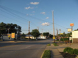
Downtown Fairfax Fairfax OH USA.JPG
Downtown Fairfax

Fairfax is a village in Hamilton County, Ohio, United States. It is a suburb of Cincinnati. The population was 1,768 at the 2020 census.

Contents

History

Fairfax incorporated as a village in 1955 to head off annexation from neighboring Cincinnati but remained connected to Columbia Township after incorporating. [7] On January 1, 2010, it withdrew from Columbia Township by forming a paper township, due in part to city residents' low tax contribution compared to their influence on township elections. [1] [2]

Geography

Fairfax is located at 39°8′34″N84°23′46″W / 39.14278°N 84.39611°W / 39.14278; -84.39611 (39.142760, -84.396188) and has a total area of 0.76 square miles (1.97 km2), all land. [8] [9]

The village is bordered by the City of Cincinnati to the north, west, and south, the Village of Mariemont to the east and south, and Columbia Township to the south. [10] Fairfax borders four City of Cincinnati neighborhoods: Madisonville to the north, Hyde Park and Mount Lookout to the west, and Linwood to the south. [11]

Little Duck Creek runs through Fairfax eventually making its way to larger Duck Creek and the nearby Little Miami River which feeds into the Ohio River. Little Duck Creek splits the village into what residents refer to as "Lower Fairfax", and "Upper Fairfax". Lower Fairfax is a low lying area in the northeast residential portion of the village that has frequently flooded via the creek during heavy rains which has resulted in multiple fatalities. [12] [13] The village has purchased and demolished homes in Lower Fairfax utilizing federal funds to mitigate flood damages. [14]

Demographics

Historical population
CensusPop.Note
1960 2,430
1970 2,70511.3%
1980 2,222−17.9%
1990 2,029−8.7%
2000 1,938−4.5%
2010 1,699−12.3%
2020 1,7684.1%
U.S. Decennial Census [15]

2020 Census

As of the census of 2020, there were 1,768 people living in the village, for a population density of 2,269.58 people per square mile (876.83/km2). There were 774 housing units. The racial makeup of the village was 88.5% White, 2.1% Black or African American, 0.3% Native American, 1.5% Asian, 0.0% Pacific Islander, 0.8% from some other race, and 5.8% from two or more races. 3.4% of the population were Hispanic or Latino of any race. [16]

There were 994 households, out of which 27.4% had children under the age of 18 living with them, 37.3% were married couples living together, 13.0% had a male householder with no spouse present, and 41.8% had a female householder with no spouse present. 36.0% of all households were made up of individuals, and 14.6% were someone living alone who was 65 years of age or older. The average household size was 2.16, and the average family size was 2.91. [16]

22.6% of the village's population were under the age of 18, 62.9% were 18 to 64, and 14.5% were 65 years of age or older. The median age was 37.1. For every 100 females, there were 69.2 males. [16]

According to the U.S. Census American Community Survey, for the period 2016-2020 the estimated median annual income for a household in the village was $68,712, and the median income for a family was $90,670. About 4.0% of the population were living below the poverty line, including 4.7% of those under age 18 and 5.1% of those age 65 or over. About 72.9% of the population were employed, and 50.1% had a bachelor's degree or higher. [16]

2010 Census

At the 2010 census there were 1,699 people, 709 households, and 455 families living in the village. The population density was 2,235.5 inhabitants per square mile (863.1/km2). There were 778 housing units at an average density of 1,023.7 per square mile (395.3/km2). The racial makeup of the village was 94.8% White, 2.4% African American, 0.3% Native American, 0.8% Asian, 0.1% from other races, and 1.6% from two or more races. Hispanic or Latino of any race were 1.3%. [17]

Of the 709 households, 34.4% had children under the age of 18 living with them, 41.9% were married couples living together, 16.8% had a female householder with no husband present, 5.5% had a male householder with no wife present, and 35.8% were non-families. 29.5% of households were one person and 9.8% were one person aged 65 or older. The average household size was 2.40 and the average family size was 2.97.

The median age in the village was 37.7 years. 24.4% of residents were under the age of 18; 6.9% were between the ages of 18 and 24; 29.6% were from 25 to 44; 27.8% were from 45 to 64; and 11.4% were 65 or older. The gender makeup of the village was 46.5% male and 53.5% female.

Education

Fairfax feeds into the Mariemont City School District, which includes Mariemont High School. Mariemont Junior High School is the only school in the district that sits within the village Mariemont Junior High School.

Related Research Articles

<span class="mw-page-title-main">Hamilton County, Ohio</span> County in Ohio, United States

Hamilton County is located in the southwestern corner of the U.S. state of Ohio. As of the 2020 census, the population was 830,639, making it the third-most populous county in Ohio. The county seat and largest city is Cincinnati. The county is named for the first Secretary of the Treasury, Alexander Hamilton. Hamilton County is part of the Cincinnati-Middletown, OH-KY-IN Metropolitan Statistical Area.

<span class="mw-page-title-main">Cherry Fork, Ohio</span> Unincorporated community in Ohio, United States

Cherry Fork is an unincorporated community and former village in Wayne Township, Adams County, Ohio, United States. The population was 170 at the 2020 census. In 2014, voters chose to disincorporate the village.

<span class="mw-page-title-main">Millville, Ohio</span> Village in Ohio, United States

Millville is a village in Butler County, Ohio, United States. The population was 634 at the 2020 census. Millville sits between Oxford, Ohio and Cincinnati, Ohio along U.S. Route 27.

<span class="mw-page-title-main">Somerville, Ohio</span> Census-designated place in Ohio, United States

Somerville is a census-designated place (CDP) and former village in Milford Township, Butler County, Ohio, United States. The population was 258 at the 2020 census.

<span class="mw-page-title-main">Neville, Ohio</span> Village in Ohio, United States

Neville is a village in Clermont County, Ohio, United States, along the Ohio River. The population was 87 at the 2020 census.

<span class="mw-page-title-main">New Richmond, Ohio</span> Village in Ohio, United States

New Richmond, also known as New Richmond on the Ohio, is a village in Ohio and Pierce townships in Clermont County, Ohio, United States, founded in 1814, along the Ohio River. The population was 2,727 at the 2020 census.

<span class="mw-page-title-main">Cleves, Ohio</span> City in Ohio, United States

Cleves is a village in Miami Township, Hamilton County, Ohio, United States. Located along the Ohio River, it is a western suburb of Cincinnati. The population was 3,414 at the 2020 census.

<span class="mw-page-title-main">Mariemont, Ohio</span> Village in Ohio, United States

Mariemont is a village in Hamilton County, Ohio, United States. A planned community in the Cincinnati metropolitan area, it includes two overlapping historic districts, the Village of Mariemont and Mariemont Historic District. In 2007, the Village of Mariemont was designated a National Historic Landmark. The population was 3,518 at the 2020 census.

<span class="mw-page-title-main">Newtown, Ohio</span> Village in Ohio, United States

Newtown is a village in southeastern Hamilton County, Ohio, United States, near Cincinnati. The population was 2,702 at the 2020 census. Newtown was settled in 1792 and incorporated as a village in 1901.

<span class="mw-page-title-main">North Bend, Ohio</span> Village in Ohio, United States

North Bend is a village in Miami Township, Hamilton County, Ohio, United States, along the Ohio River. It is a part of the Greater Cincinnati area. The population was 835 at the 2020 census.

<span class="mw-page-title-main">Terrace Park, Ohio</span> Village in Ohio, United States

Terrace Park is a village in Hamilton County, Ohio, and a suburb of Greater Cincinnati. The population was 2,355 at the 2020 census.

<span class="mw-page-title-main">Indian Hill, Ohio</span> City in Ohio, United States

The Village of Indian Hill is a city in Hamilton County, Ohio, United States, and a suburb of the Greater Cincinnati area. The population was 6,087 at the 2020 census. Prior to 1970, Indian Hill was incorporated as a village, but under Ohio law became designated as a city once its population was verified as exceeding 5,000. The municipality then changed its name to add "Village" into the official name; legally it is "The City of The Village of Indian Hill". The Village of Indian Hill is served by the Indian Hill Exempted Village School District.

<span class="mw-page-title-main">Sardinia, Ohio</span> Village in Ohio, United States

Sardinia is a village in Brown and Highland counties in the U.S. state of Ohio. The population was 1,083 at the 2020 census.

<span class="mw-page-title-main">College Corner, Ohio</span> Village in Ohio, United States

College Corner is a village in Butler and Preble counties in the southwestern part of the U.S. state of Ohio, 5 miles (8 km) northwest of Oxford. The population was 387 at the 2020 census. The village lies on the state line with Indiana, where it borders the town of West College Corner. The public school, part of the Union County–College Corner Joint School District, is bisected by the state line and is operated jointly with Indiana authorities.

<span class="mw-page-title-main">Colerain Township, Hamilton County, Ohio</span> Township in Ohio, United States

Colerain Township is one of the twelve townships of Hamilton County, Ohio, United States. The population of the township was 59,037 at the 2020 census. It is the second-largest township in Ohio by area, surpassed by Madison Township, Lake County, Ohio.

<span class="mw-page-title-main">Columbia Township, Hamilton County, Ohio</span> Township in Ohio, United States

Columbia Township is one of the twelve townships of Hamilton County, Ohio, United States. The 2020 census found 4,446 people in the township. Originally one of Ohio's largest townships by area at its inception in 1791, it gradually shrank to one of the smallest by the early 1950s.

<span class="mw-page-title-main">Miami Township, Hamilton County, Ohio</span> Township in Ohio, United States

Miami Township is one of the twelve townships of Hamilton County, Ohio, United States. The population was 15,969 as of the 2020 census.

<span class="mw-page-title-main">Dunlap, Ohio</span> Census-designated place in Ohio, United States

Dunlap is a census-designated place (CDP) in Colerain Township, Hamilton County, Ohio, United States. The population was 1,658 at the 2020 census. The siege of Dunlap's Station was a battle that took place near here on the Great Miami in 1791 during the Northwest Indian War.

<span class="mw-page-title-main">Brecon, Ohio</span> Census-designated place in Ohio, United States

Brecon is a census-designated place (CDP) in Sycamore Township, Hamilton County, Ohio, United States. The population was 408 at the 2020 census.

Madison Place is a census-designated place (CDP) in Hamilton County, Ohio, United States, adjacent to the city of Cincinnati. It was first listed as a CDP prior to the 2020 census. The population was 572 at the 2020 census.

References

  1. 1 2 Kemme, Steve (June 22, 2009). "Fairfax may be its own township". The Cincinnati Enquirer . p. B3.
  2. 1 2 Kemme, Steve; Wilkinson, Howard (November 4, 2009). "Township vote causes confusion in Fairfax". The Cincinnati Enquirer. p. B2.
  3. "Election Night Reporting". Hamilton County Board of Elections. Retrieved November 9, 2023.
  4. "ArcGIS REST Services Directory". United States Census Bureau. Retrieved September 20, 2022.
  5. 1 2 U.S. Geological Survey Geographic Names Information System: Fairfax, Ohio
  6. "U.S. Census website". United States Census Bureau . Retrieved January 31, 2008.
  7. "History of the Township".
  8. "US Gazetteer files 2010". United States Census Bureau. Archived from the original on January 25, 2012. Retrieved January 6, 2013.
  9. "US Gazetteer files: 2010, 2000, and 1990". United States Census Bureau. February 12, 2011. Retrieved April 23, 2011.
  10. "Hamilton County Civil and Municipal Boundaries | Tyler Data & Insights".
  11. chrome-extension://efaidnbmnnnibpcajpcglclefindmkaj/https://www.cincinnati-oh.gov/sites/planning/assets/File/Jurisdictions%20Inside%20City%20Boundaries.pdf
  12. "CNN.com - Two dead, one missing in flooding near Cincinnati - July 18, 2001". www.cnn.com.
  13. "Fairfax, Ohio Flood Factor® Report".
  14. "Fairfax flood house to become green space". December 10, 2015.
  15. "Census of Population and Housing". Census.gov. Retrieved June 4, 2015.
  16. 1 2 3 4 "Fairfax village, Ohio - Census Bureau Profile". United States Census Bureau. Retrieved October 15, 2023.
  17. "U.S. Census website". United States Census Bureau . Retrieved January 6, 2013.