Pleasant Run Farm, Ohio

Last updated

Pleasant Run Farm, Ohio
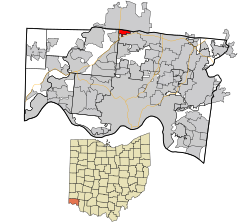
Hamilton County Ohio Incorporated and Unincorporated areas Pleasant Run Farm highlighted.svg
Location in Hamilton County and the state of Ohio
Coordinates: 39°18′06″N84°32′58″W / 39.30167°N 84.54944°W / 39.30167; -84.54944
Country United States
State Ohio
County Hamilton
Township Springfield
Area
[1]
  Total1.06 sq mi (2.75 km2)
  Land1.06 sq mi (2.75 km2)
  Water0.00 sq mi (0.00 km2)
Elevation
[2]
764 ft (233 m)
Population
 (2020)
  Total4,779
  Density4,495.77/sq mi (1,736.12/km2)
Time zone UTC-5 (Eastern (EST))
  Summer (DST) UTC-4 (EDT)
FIPS code 39-63618 [3]
GNIS feature ID2393191 [2]

Pleasant Run Farm is a census-designated place (CDP) in Springfield Township, Hamilton County, Ohio, United States. The population was 4,779 at the 2020 census.

Contents

History

Pleasant Run Farm is named after the Pleasant Run Farms[ sic ] residential subdivision, which hosted the Home Builders Association of Greater Cincinnati's fifth annual Homearama show in 1965. At 670 acres (270 ha), it was the largest subdivision approved by the Hamilton County Regional Planning Commission up to that time. An additional 100 homes were added to the subdivision beginning in 1967. The Pleasant Run Farms Civic Association was founded in 1969. [4]

Geography

Pleasant Run Farm is located northwest of Cincinnati, between Forest Park and Fairfield.

According to the United States Census Bureau, the CDP has a total area of 1.0 square miles (2.7 km2), all land.

Pleasant Run is located to the west in neighboring Colerain Township.

Demographics

Historical population
CensusPop.Note
2020 4,779
U.S. Decennial Census [5]

2020 census

As of the census of 2020, there were 4,779 people living in the CDP, for a population density of 4,495.77 people per square mile (1,736.12/km2). There were 1,808 housing units. The racial makeup of the CDP was 44.5% White, 42.3% Black or African American, 0.2% Native American, 3.8% Asian, 0.2% Pacific Islander, 3.2% from some other race, and 5.8% from two or more races. 5.2% of the population were Hispanic or Latino of any race. [6]

There were 1,558 households, out of which 27.9% had children under the age of 18 living with them, 45.5% were married couples living together, 11.9% had a male householder with no spouse present, and 38.4% had a female householder with no spouse present. 31.9% of all households were made up of individuals, and 14.8% were someone living alone who was 65 years of age or older. The average household size was 2.44, and the average family size was 3.07. [6]

19.9% of the CDP's population were under the age of 18, 56.8% were 18 to 64, and 23.3% were 65 years of age or older. The median age was 48.2. For every 100 females, there were 87.1 males. [6]

According to the U.S. Census American Community Survey, for the period 2016-2020 the estimated median annual income for a household in the CDP was $79,500, and the median income for a family was $89,957. About 5.1% of the population were living below the poverty line, including 3.6% of those under age 18 and 9.8% of those age 65 or over. About 58.5% of the population were employed, and 36.0% had a bachelor's degree or higher. [6]

2000 census

At the 2000 census there were 4,731 people, 1,637 households, and 1,314 families in the CDP. The population density was 4,511.4 inhabitants per square mile (1,741.9/km2). There were 1,689 housing units at an average density of 1,610.6 per square mile (621.9/km2). The racial makeup of the CDP was 74.13% White, 22.85% African American, 0.11% Native American, 1.37% Asian, 0.06% Pacific Islander, 0.36% from other races, and 1.12% from two or more races. Hispanic or Latino of any race were 0.68%. [3]

Of the 1,637 households 45.7% had children under the age of 18 living with them, 63.8% were married couples living together, 13.1% had a female householder with no husband present, and 19.7% were non-families. 16.1% of households were one person and 4.6% were one person aged 65 or older. The average household size was 2.89 and the average family size was 3.25.

The age distribution was 31.3% under the age of 18, 9.1% from 18 to 24, 29.7% from 25 to 44, 23.3% from 45 to 64, and 6.6% 65 or older. The median age was 32 years. For every 100 females, there were 91.2 males. For every 100 females age 18 and over, there were 88.1 males.

The median household income was $61,359 and the median family income was $64,718. Males had a median income of $46,667 versus $30,085 for females. The per capita income for the CDP was $22,388. About 4.2% of families and 4.8% of the population were below the poverty line, including 6.7% of those under age 18 and 5.8% of those age 65 or over.
Related Research Articles

<span class="mw-page-title-main">Kent Acres, Delaware</span> CDP in Delaware, United States

Kent Acres is a census-designated place (CDP) in Kent County, Delaware, United States. It is part of the Dover, Delaware Metropolitan Statistical Area. The population was 1,890 at the 2010 census.

<span class="mw-page-title-main">North Amherst, Massachusetts</span> Census-designated place in Massachusetts, United States

North Amherst is a census-designated place (CDP) in the city of Amherst in Hampshire County, Massachusetts, United States. The population was 6,819 at the 2010 census, up from 6,019 at the 2000 census. It is part of the Springfield, Massachusetts Metropolitan Statistical Area.

<span class="mw-page-title-main">Helena West Side, Montana</span> Census-designated place in Montana, United States

Helena West Side is a census-designated place (CDP) in Lewis and Clark County, Montana, United States. The population was 1,637 at the 2010 census, down from 1,711 at the 2000 census due to annexation of part of the CDP by the city of Helena. It is part of the Helena Micropolitan Statistical Area.

<span class="mw-page-title-main">East Freehold, New Jersey</span> Populated place in Monmouth County, New Jersey, US

East Freehold is an unincorporated community and census-designated place (CDP) located within Freehold Township, in Monmouth County, in the U.S. state of New Jersey. As of the 2010 United States Census, the CDP's population was 4,894.

<span class="mw-page-title-main">Park Layne, Ohio</span> Census-designated place in Ohio, United States

Park Layne is a census-designated place (CDP) in Bethel Township, Clark County, Ohio, United States. The population of the CDP was 4,248 at the 2020 census. It is part of the Springfield, Ohio Metropolitan Statistical Area. Park Layne became a CDP in the 1980 United States Census.

<span class="mw-page-title-main">Dry Run, Ohio</span> Census-designated place in Ohio, United States

Dry Run is a census-designated place (CDP) in Hamilton County, Ohio, United States. The population was 7,672 at the 2020 census.

<span class="mw-page-title-main">Grandview, Hamilton County, Ohio</span> Census-designated place in Ohio, United States

Grandview is a census-designated place (CDP) in Hamilton County, Ohio, United States. The population was 1,312 at the 2020 census.

<span class="mw-page-title-main">Mount Healthy Heights, Ohio</span> Census-designated place in Ohio, United States

Mount Healthy Heights is a census-designated place (CDP) in Hamilton County, Ohio, United States. The population was 2,918 at the 2020 census.

<span class="mw-page-title-main">Pleasant Run, Ohio</span> Census-designated place in Ohio, United States

Pleasant Run is a census-designated place (CDP) in Colerain Township, Hamilton County, Ohio, United States. The population was 4,861 at the 2020 census.

<span class="mw-page-title-main">Sherwood, Hamilton County, Ohio</span> Census-designated place in Ohio, United States

Sherwood is a census-designated place (CDP) in Hamilton County, Ohio, United States. The population was 3,633 at the 2020 census.

<span class="mw-page-title-main">Turpin Hills, Ohio</span> Census-designated place in Ohio, United States

Turpin Hills is a census-designated place (CDP) in Anderson Township, Hamilton County, Ohio, United States. The population was 5,162 at the 2020 census.

<span class="mw-page-title-main">White Oak, Ohio</span> Census-designated place in Ohio, United States

White Oak is a census-designated place (CDP) in Hamilton County, Ohio, United States. It is seven miles northwest of Cincinnati. The population was 19,541 at the 2020 census. White Oak is situated in both Green Township and Colerain Township.

<span class="mw-page-title-main">Pleasant Grove, Ohio</span> CDP in Ohio, United States

Pleasant Grove is a census-designated place (CDP) in Muskingum County, Ohio, United States. The population was 1,726 at the 2020 census.

<span class="mw-page-title-main">Pleasant Gap, Pennsylvania</span> Census-designated place in Pennsylvania, United States

Pleasant Gap is an unincorporated community and census-designated place (CDP) in Centre County, Pennsylvania, United States. It is part of the State College, Pennsylvania Metropolitan Statistical Area. The population was 2,879 at the 2010 census.

<span class="mw-page-title-main">Brodheadsville, Pennsylvania</span> Census-designated place in Pennsylvania, United States

Brodheadsville is a census-designated place (CDP) in Monroe County, Pennsylvania, United States. The population was 1,700 at the 2020 census. The community is served by Pleasant Valley School District.

<span class="mw-page-title-main">Buck Run, Pennsylvania</span> CDP in Pennsylvania, United States

Buck Run is a census-designated place (CDP) in Schuylkill County, Pennsylvania, United States. The population was 176 at the 2010 census.

<span class="mw-page-title-main">Loveland Park, Ohio</span> Census-designated place in Ohio, United States

Loveland Park is a census-designated place (CDP) located in Symmes Township, Hamilton County and Deerfield Township, Warren County, in the southwestern part of the U.S. state of Ohio. The CDP is named after the city of Loveland. The population was 1,737 at the 2020 census.

<span class="mw-page-title-main">Winchendon (CDP), Massachusetts</span> Census-designated place in Massachusetts, United States

Winchendon is a census-designated place (CDP) in the town of Winchendon in Worcester County, Massachusetts, United States. The population was 4,213 at the 2010 census.

<span class="mw-page-title-main">Brimfield (CDP), Ohio</span> CDP in Ohio, United States

Brimfield is a census-designated place (CDP) in Portage County, Ohio, United States. As of the 2020 census, the CDP had a population of 3,365. It is located in the central part of Brimfield Township, a rural area between the Ohio cities of Akron and Kent with light industry, strip-malls, subdivisions, and farms.

Pleasant Hills is a census-designated place (CDP) in Hamilton County, Ohio, United States. The population was 950 at the 2020 census.

References

  1. "ArcGIS REST Services Directory". United States Census Bureau. Retrieved September 20, 2022.
  2. 1 2 U.S. Geological Survey Geographic Names Information System: Pleasant Run Farm, Ohio
  3. 1 2 "U.S. Census website". United States Census Bureau . Retrieved January 31, 2008.
  4. "PRF History". Pleasant Run Farm, Ohio: Pleasant Run Farms Civic Association. Retrieved January 31, 2024.
  5. "Census of Population and Housing". Census.gov. Retrieved June 4, 2016.
  6. 1 2 3 4 "Pleasant Run Farm CDP, Ohio - Census Bureau Profile". United States Census Bureau. Retrieved November 26, 2023.