Green Township, Hamilton County, Ohio

Last updated

Green Township, Hamilton County, Ohio
Green Township Municipal Building.jpg
Green Township Administration Building
Hamilton County Ohio Incorporated and Unincorporated areas Green township highlighted.svg
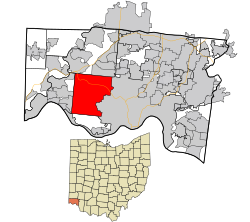
Location in Hamilton County and the state of Ohio.
Coordinates: 39°9′58″N84°37′55″W / 39.16611°N 84.63194°W / 39.16611; -84.63194
Country United States
State Ohio
County Hamilton
Area
  Total27.9 sq mi (72.2 km2)
  Land27.9 sq mi (72.2 km2)
  Water0.0 sq mi (0.0 km2)
Elevation
[1]
892 ft (272 m)
Population
 (2020) [2]
  Total60,424
  Density2,165.7/sq mi (836.9/km2)
Time zone UTC-5 (Eastern (EST))
  Summer (DST) UTC-4 (EDT)
FIPS code 39-31752 [3]
GNIS feature ID1086212 [1]
Website www.greentwp.org

Green Township is one of the twelve townships of Hamilton County, Ohio, United States. It is a suburb of the neighboring city of Cincinnati. With a population of 60,424 at the 2020 census, Green Township is the most populous township in Hamilton County, and the second most populous township in Ohio. [4] It was founded in 1809.

Contents

History

It is one of sixteen Green Townships statewide. [5]

The township was originally held intact by John Cleves Symmes, with the apparent intent of naming it as the academy township for his purchase. In 1802 a court order awarded half the township to one of his Miami Company investors, Elias Boudinot. This became part of the disputes over the entire Symmes Purchase. The township is named after Nathanael Greene, a Revolutionary War general. [6]

The township was home to The Western Hills Airport (Also called "Frank Airport" and "Cheviot Airport") and was the first airport in western Hamilton County, Ohio. The airport was located in the neighborhood of Bridgetown, Ohio. Airport operations began in 1929, shutdown during World War II, then reopened after the end of the war, slowly declining until the corporation ceased services in 1949 as aircraft outgrew the facilities.[ citation needed ]

Geography

Located in the west central part of the county, it borders the following townships and city:

Two cities occupy what was once part of Green Township: Cheviot in the east center, and Cincinnati, the county seat of Hamilton County, in the east and southeast. Nearly all of the remainder of the township is part of one of the following census-designated places:

The township encompasses 27.9 sq mi (72.3 km2) of gently rolling hills above the Ohio River northwest of downtown Cincinnati. As of 1990, over 50% of the township's area has been was converted to urban use, largely as a suburb of Cincinnati; 38% is classed as forested, and 11% as farmland.

Demographics

Historical population
CensusPop.Note
1820 1,456
1850 3,948
1860 4,42612.1%
1870 4,356−1.6%
1880 4,85111.4%
1890 5,0884.9%
1900 4,716−7.3%
1910 6,30633.7%
1920 8,05027.7%
1930 13,17263.6%
1940 18,46340.2%
1950 27,16647.1%
1960 47,99176.7%
1970 49,9174.0%
1980 50,7171.6%
1990 52,6873.9%
2000 55,6605.6%
2010 58,3704.9%
2020 60,4243.5%
Sources: [7] [2]

2020 census

As of the census of 2020, there were 60,424 people living in the township, for a population density of 2,165.7 people per square mile (836.9/km2). There were 25,296 housing units. The racial makeup of the township was 87.8% White, 5.5% Black or African American, 0.1% Native American, 1.6% Asian, 0.0% Pacific Islander, 0.6% from some other race, and 4.3% from two or more races. 1.6% of the population were Hispanic or Latino of any race. [2]

There were 23,407 households, out of which 33.4% had children under the age of 18 living with them, 52.8% were married couples living together, 15.4% had a male householder with no spouse present, and 25.3% had a female householder with no spouse present. 27.2% of all households were made up of individuals, and 14.0% were someone living alone who was 65 years of age or older. The average household size was 2.56, and the average family size was 3.13. [2]

26.4% of the township's population were under the age of 18, 55.7% were 18 to 64, and 17.9% were 65 years of age or older. The median age was 37.8. For every 100 females, there were 90.4 males. [2]

According to the U.S. Census American Community Survey, for the period 2016-2020 the estimated median annual income for a household in the township was $77,074, and the median income for a family was $99,342. About 5.3% of the population were living below the poverty line, including 6.9% of those under age 18 and 4.6% of those age 65 or over. About 65.3% of the population were employed, and 38.6% had a bachelor's degree or higher. [2]

Government

The township is governed by a three-member board of trustees, who are elected in November of odd-numbered years to a four-year term beginning on the following January 1. Two are elected in the year after the presidential election and one is elected in the year before it. There is also an elected township fiscal officer, [8] who serves a four-year term beginning on April 1 of the year after the election, which is held in November of the year before the presidential election. Vacancies in the fiscal officership or on the board of trustees are filled by the remaining trustees.

Parks

Green Township has a township park system with six different parks including: [9]

Education

Catholic schools

There are several Catholic schools in Green Township. This includes LaSalle High School, St. Antoninus, Our Lady of Visitation, St. Aloysius Gonzaga, St. Jude, St. James White Oak, and St. Ignatius.

Public schools

Most of Green Township is within the Oak Hills Local School District. The Monfort Heights and White Oak areas of Green Township are within the Northwest Local School District.

Within the Oak Hills Local School District:

Oakdale Elementary School, Bridgetown Middle School and Oak Hills High School are within Bridgetown, Green Township. [10] [11] John F. Dulles Elementary School is within Mack. [10] [12] Springmyer Elementary School is also within Mack. [10] [13]

Within the Northwest Local School District:

Two Northwest schools are located in Green Township. Monfort Heights Elementary School serves Monfort Heights students, while White Oak Middle School serves White Oak and Monfort Heights students.

Three Northwest schools located in Colerain Township serve Green Township students. Ann Weigel Elementary School and Struble Elementary School serve White Oak students, while Colerain High School serves Monfort Heights and White Oak students.

Public libraries

Public Library of Cincinnati and Hamilton County operates the Green Township Branch in Mack and the Monfort Heights Branch in Monfort Heights. [12] [14] The Green Township branch, which opened in January 1990, has a central copper dome with two smaller domed structures, which were designed to resemble barns of horse farms which at one time prevalent in Green Township. [14]

Notable people

Related Research Articles

<span class="mw-page-title-main">Hamilton County, Ohio</span> County in Ohio, United States

Hamilton County is located in the southwestern corner of the U.S. state of Ohio. As of the 2020 census, the population was 830,639, making it the third-most populous county in Ohio. The county seat and largest city is Cincinnati. The county is named for the first Secretary of the Treasury, Alexander Hamilton. Hamilton County is part of the Cincinnati-Middletown, OH-KY-IN Metropolitan Statistical Area.

<span class="mw-page-title-main">Oakland County, Michigan</span> County in Michigan, United States

Oakland County is a county in the U.S. state of Michigan. It is a principal county of the Detroit metropolitan area, containing the bulk of Detroit's northern suburbs. Its county seat is Pontiac, and its largest city is Troy. As of the 2020 Census, its population was 1,274,395, making it the second-most populous county in Michigan, and the largest county in the United States without a city of 100,000 residents.

<span class="mw-page-title-main">Ross, Ohio</span> Census-designated place in Ohio, United States

Ross is a census-designated place (CDP) in Ross Township, Butler County, Ohio, United States. The population was 3,478 at the 2020 census. Ross sits along U.S. Route 27 between Cincinnati, Ohio and Oxford, Ohio. Ross is part of the Cincinnati metropolitan area.

<span class="mw-page-title-main">Grandview, Hamilton County, Ohio</span> Census-designated place in Ohio, United States

Grandview is a census-designated place (CDP) in Hamilton County, Ohio, United States. The population was 1,312 at the 2020 census.

<span class="mw-page-title-main">White Oak, Ohio</span> Census-designated place in Ohio, United States

White Oak is a census-designated place (CDP) in Hamilton County, Ohio, United States. It is seven miles northwest of Cincinnati. The population was 19,541 at the 2020 census. White Oak is situated in both Green Township and Colerain Township.

<span class="mw-page-title-main">Penn Hills, Pennsylvania</span> Home rule township in Pennsylvania, United States

Penn Hills is a township with home rule status in Allegheny County, Pennsylvania, United States. The population was 41,059 as of the 2020 census. A suburb of Pittsburgh, Penn Hills is the second-largest municipality in Allegheny County.

<span class="mw-page-title-main">Anderson Township, Ohio</span> Township in Ohio, United States

Anderson Township is a township located southeastern Hamilton County along the Ohio and Little Miami Rivers, approximately 13 miles southeast of downtown Cincinnati. The population was 44,088 at the 2020 census.

<span class="mw-page-title-main">Colerain Township, Hamilton County, Ohio</span> Township in Ohio, United States

Colerain Township is one of the twelve townships of Hamilton County, Ohio, United States. The population of the township was 59,037 at the 2020 census. It is the second-largest township in Ohio by area, surpassed by Madison Township, Lake County, Ohio.

<span class="mw-page-title-main">Columbia Township, Hamilton County, Ohio</span> Township in Ohio, United States

Columbia Township is one of the twelve townships of Hamilton County, Ohio, United States. The 2020 census found 4,446 people in the township. Originally one of Ohio's largest townships by area at its inception in 1791, it gradually shrank to one of the smallest by the early 1950s.

<span class="mw-page-title-main">Delhi Township, Ohio</span> Township in Ohio, United States

Delhi Township is one of the twelve townships of Hamilton County, Ohio, United States. The 2020 census found 28,760 people in the township. It is the only Delhi Township statewide.

<span class="mw-page-title-main">Miami Township, Hamilton County, Ohio</span> Township in Ohio, United States

Miami Township is one of the twelve townships of Hamilton County, Ohio, United States. The population was 15,969 as of the 2020 census.

<span class="mw-page-title-main">Springfield Township, Hamilton County, Ohio</span> Township in Ohio, United States

Springfield Township is one of the twelve townships of Hamilton County, Ohio, United States. The population was 35,862 as of the 2020 census. Springfield Township is home to the largest private school in Ohio, the largest lake in Hamilton County, and the Cincinnati area's annual Greek Festival.

<span class="mw-page-title-main">Bridgetown, Ohio</span> Census-designated place in Ohio, United States

Bridgetown is a census-designated place (CDP) in Green Township, Hamilton County, Ohio, United States. The population was 14,731 at the 2020 census. In earlier censuses it was listed as the slightly smaller Bridgetown North CDP.

Northwest Local School District is a public school district in Hamilton County, Ohio, near Cincinnati, Ohio. It primarily serves Colerain Township, but also includes parts of neighboring Green Township, Springfield Township, and Ross Township.

<span class="mw-page-title-main">Mack, Ohio</span> Census-designated place in Ohio, United States

Mack is a census-designated place (CDP) in Green and Miami townships, Hamilton County, Ohio, United States. The population was 11,088 at the 2020 census. At prior censuses, the community was listed as two separate CDPs, Mack North and Mack South.

<span class="mw-page-title-main">Monfort Heights, Ohio</span> Census-designated place in Ohio, United States

Monfort Heights is a census-designated place (CDP) in Green Township, Hamilton County, Ohio, United States, part of the Cincinnati–Northern Kentucky metropolitan area. The population of Monfort Heights was 12,070 at the 2020 census. In previous censuses, the area was listed as two separate CDPs, Monfort Heights East and Monfort Heights South.

<span class="mw-page-title-main">Dunlap, Ohio</span> Census-designated place in Ohio, United States

Dunlap is a census-designated place (CDP) in Colerain Township, Hamilton County, Ohio, United States. The population was 1,658 at the 2020 census. The siege of Dunlap's Station was a battle that took place near here on the Great Miami in 1791 during the Northwest Indian War.

<span class="mw-page-title-main">Colerain Heights, Ohio</span> Unincorporated community in Ohio, U.S.

Colerain Heights is an unincorporated community in Colerain Township, Hamilton County, Ohio, United States, near Cincinnati. Most of Colerain Heights is contained around the intersection of Colerain Avenue and Springdale Road in Colerain Township. K-12 Students in the small community attend schools in the Northwest Local School District within Colerain and Green Townships. The community contains Northgate Mall, one of Cincinnati's major shopping malls, which contains stores such as Macy's, Sears, Aeropostale, Foot Locker, among other stores.

<span class="mw-page-title-main">Miami Heights, Ohio</span> Census-designated place in Ohio, United States

Miami Heights is a census-designated place (CDP) in Miami Township, Hamilton County, Ohio, United States. The population was 5,166 at the 2020 census.

<span class="mw-page-title-main">Taylor Creek, Ohio</span> Census-designated place in Ohio, United States

Taylor Creek is a census-designated place (CDP) in Colerain Township, Hamilton County, Ohio, United States. The population was 4,056 at the 2020 census.

References

  1. 1 2 "US Board on Geographic Names". United States Geological Survey. October 25, 2007. Retrieved January 31, 2008.
  2. 1 2 3 4 5 6 "Green township, Hamilton County, Ohio - Census Bureau Profile". United States Census Bureau. Retrieved September 28, 2023.
  3. "U.S. Census website". United States Census Bureau . Retrieved January 31, 2008.
  4. "Ohio Townships and the U.S. Census". Ohio Township Association. Retrieved June 23, 2023.
  5. "Detailed map of Ohio" (PDF). United States Census Bureau. 2000. Retrieved February 16, 2007.
  6. Lueders, Jeffrey R. (2006). Hamilton County's Green Township. Arcadia Publishing. p. 8. ISBN   9780738541174 . Retrieved December 11, 2013.
  7. "Decennial Census by Decade". United States Census Bureau. Retrieved October 28, 2023.
  8. §503.24, §505.01, and §507.01 of the Ohio Revised Code. Accessed 4/30/2009.
  9. "About the Parks Department". Green Township, OH. Green Township Government. Retrieved November 9, 2021.
  10. 1 2 3 "Our Schools Archived 2009-02-28 at the Wayback Machine ." Oak Hills Local School District. Retrieved on December 14, 2009.
  11. "Bridgetown North CDP [ permanent dead link ]." U.S. Census Bureau. Retrieved on December 14, 2009.
  12. 1 2 "Mack South CDP, Ohio [ permanent dead link ]." U.S. Census Bureau. Retrieved on December 14, 2009.
  13. "Mack North CDP, Ohio [ permanent dead link ]." U.S. Census Bureau. Retrieved on December 14, 2009.
  14. 1 2 "Green Township Branch." Public Library of Cincinnati and Hamilton County. Retrieved on December 13, 2009.