Mount Healthy Heights, Ohio | |
---|---|
Coordinates: 39°16′13″N84°34′09″W / 39.27028°N 84.56917°W | |
Country | United States |
State | Ohio |
County | Hamilton |
Area | |
• Total | 0.74 sq mi (1.92 km2) |
• Land | 0.73 sq mi (1.90 km2) |
• Water | 0.01 sq mi (0.01 km2) |
Elevation | 853 ft (260 m) |
Population (2020) | |
• Total | 2,918 |
• Density | 3,975.48/sq mi (1,534.62/km2) |
Time zone | UTC-5 (Eastern (EST)) |
• Summer (DST) | UTC-4 (EDT) |
ZIP code | 45231 [3] |
Area code(s) | 283 and 513 |
FIPS code | 39-52780 [4] |
GNIS feature ID | 2393139 [2] |
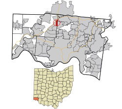
Mount Healthy Heights is a census-designated place (CDP) in Colerain Township, Hamilton County, Ohio, United States. The population was 2,918 at the 2020 census.
According to the United States Census Bureau, the CDP has a total area of 0.8 square mile (2.0 km2), all land.
Census | Pop. | Note | %± |
---|---|---|---|
2020 | 2,918 | — | |
U.S. Decennial Census [5] |
As of the census of 2020, there were 2,918 people living in the CDP, for a population density of 3,975.48 people per square mile (1,534.62/km2). There were 1,409 housing units. The racial makeup of the CDP was 49.8% White, 36.2% Black or African American, 0.1% Native American, 3.6% Asian, 0.1% Pacific Islander, 2.7% from some other race, and 7.4% from two or more races. 4.7% of the population were Hispanic or Latino of any race. [6]
There were 1,081 households, out of which 53.3% had children under the age of 18 living with them, 50.5% were married couples living together, 11.8% had a male householder with no spouse present, and 34.1% had a female householder with no spouse present. 14.3% of all households were made up of individuals, and 4.6% were someone living alone who was 65 years of age or older. The average household size was 3.29, and the average family size was 3.70. [6]
45.6% of the CDP's population were under the age of 18, 48.1% were 18 to 64, and 6.3% were 65 years of age or older. The median age was 27.0. For every 100 females, there were 98.1 males. [6]
According to the U.S. Census American Community Survey, for the period 2016-2020 the estimated median annual income for a household in the CDP was $56,042, and the median income for a family was $73,220. About 24.5% of the population were living below the poverty line, including 37.0% of those under age 18 and 0.0% of those age 65 or over. About 73.8% of the population were employed, and 25.5% had a bachelor's degree or higher. [6]
As of the census [4] of 2000, there were 3,450 people, 1,281 households, and 959 families living in the CDP. The population density was 4,489.7 inhabitants per square mile (1,733.5/km2). There were 1,320 housing units at an average density of 1,717.8 per square mile (663.2/km2). The racial makeup of the CDP was 73.28% White, 23.33% African American, 0.09% Native American, 1.22% Asian, 0.55% from other races, and 1.54% from two or more races. Hispanic or Latino of any race were 0.99% of the population.
There were 1,281 households, out of which 38.5% had children under the age of 18 living with them, 53.6% were married couples living together, 15.8% had a female householder with no husband present, and 25.1% were non-families. 18.3% of all households were made up of individuals, and 3.5% had someone living alone who was 65 years of age or older. The average household size was 2.69 and the average family size was 3.08.
In the CDP, the population was spread out, with 27.3% under the age of 18, 11.3% from 18 to 24, 33.7% from 25 to 44, 21.5% from 45 to 64, and 6.2% who were 65 years of age or older. The median age was 31 years. For every 100 females, there were 95.5 males. For every 100 females age 18 and over, there were 91.5 males.
The median income for a household in the CDP was $45,245, and the median income for a family was $49,929. Males had a median income of $32,750 versus $25,101 for females. The per capita income for the CDP was $20,726. About 2.5% of families and 4.2% of the population were below the poverty line, including 7.4% of those under age 18 and 7.8% of those age 65 or over.
Palermo is a census-designated place (CDP) in Butte County, California, United States. The population was 5,382 at the 2010 census, down from 5,720 at the 2000 census.
Taft Heights is a census-designated place (CDP) in Kern County, California, United States. Taft Heights is located 1 mile (1.6 km) west-southwest of Taft, at an elevation of 1,178 feet (359 m). The population was 1,949 at the 2010 census, up from 1,865 at the 2000 census.
South Whittier is an unincorporated community in Los Angeles County, California just south of the city of Whittier. For statistical purposes, the United States Census Bureau has defined South Whittier as a census-designated place (CDP). As of the 2020 census, the CDP had a total population of 56,415, down from 57,156 at the 2010 census.
Morada is a census-designated place (CDP) in San Joaquin County, California, United States. The population was 3,166 at the 2020 census, down from 3,828 at the 2010 census.
West Menlo Park is a census-designated place and an Unincorporated community in San Mateo County, California, located between the majority of City of Menlo Park, the Town of Atherton, the Sharon Heights neighborhood of Menlo Park and Stanford University. As of the 2020 census, the community had a population of 3,930.
Preston Heights is an unincorporated community and census-designated place (CDP) in Will County, Illinois, United States. As of the 2020 census, the CDP population was 2,898.
Pemberton Heights is an unincorporated community and census-designated place (CDP) located within Pemberton Township, in Burlington County, in the U.S. state of New Jersey. As of the 2010 United States Census, the CDP's population was 2,423.
Holiday Heights is an unincorporated community and census-designated place (CDP) located within Berkeley Township, in Ocean County, in the U.S. state of New Jersey. As of the 2010 United States Census, the CDP's population was 2,099.
Washington Heights is a census-designated place (CDP) in Orange County, New York, United States. The population was 2,205 at the 2020 census.
Day Heights is a census-designated place (CDP) in Miami Township, Clermont County, Ohio, United States. The population was 2,625 at the 2020 census.
Pleasant Run is a census-designated place (CDP) in Colerain Township, Hamilton County, Ohio, United States. The population was 4,861 at the 2020 census.
Perry Heights is a census-designated place in Stark County, Ohio, United States. The population was 8,391 at the 2020 census. It is part of the Canton–Massillon metropolitan area.
Lenape Heights is a census-designated place (CDP) in Armstrong County, Pennsylvania, United States. The population was 1,144 at the 2020 census.
Wayne Heights is a census-designated place (CDP) in Franklin County, Pennsylvania, United States. The population was 2,606 at the 2020 census.
Arlington Heights is a census-designated place (CDP) in Monroe County, Pennsylvania, United States. The population was 6,331 at the 2020 census. One notable location in Arlington Heights is the Stroud Mall.
Woodland Heights is a census-designated place (CDP) in Venango County, Pennsylvania, United States. The population was 1,402 at the 2000 census.
Longview Heights is a census-designated place (CDP) in Cowlitz County, Washington, United States. The population was 4,033 at the 2020 Census. The CDP is known locally as Columbia Heights.
Arlington Heights is a census-designated place (CDP) in Snohomish County, Washington, United States. As of the 2020 census, the population was 2,477, up from 2,284 at the 2010 census.
New Burlington is a census-designated place (CDP) in Springfield Township, Hamilton County, Ohio, United States. The population was 5,049 at the 2020 census.
Rossmoyne is a census-designated place (CDP) in Sycamore Township, Hamilton County, Ohio, United States, 13 miles (21 km) northeast of downtown Cincinnati. The population of Rossmoyne was 1,788 at the 2020 census.