Price Hill is a region of Cincinnati, Ohio consisting of three neighborhoods: East Price Hill, West Price Hill, and Lower Price Hill. The region is located in the western part of the city, neighbored by Sedamsville and Riverside to the south, Westwood and South Fairmount to the north, and Queensgate to the west. Originally one of the oldest suburbs of Cincinnati, the region is predominately Catholic, having been an ethnic enclave for both Irish and German Catholics.[2] Price Hill's neighborhoods are residential communities, having a combined population of 36,271 at the 2020 census.[3][4][5]
Before the Symmes Purchase of the 1780s, the area of Price Hill was sparsely populated Indian territory. The remains of Indian burial mounds and lookout posts were located in the area. Price Hill was originally part of both Delhi and Storrs townships. The eastern portion of the neighborhood, located in Storrs Township, became part of Cincinnati when the city annexed the whole township in 1870. West Price Hill, located in Delhi Township, was annexed three decades later in 1902.[6]
Cincinnati became heavily populated in the 19th century, due to steamboat traffic and hogpacking, and some of the city's wealthier residents settled in the nearly inaccessible hill country to the west. This region was high enough and far enough away to escape the pollution and crowdedness of the inner city. One such resident was General Rees E. Price, who purchased and developed large parts of the hill. The area was then called "Price's Hill", later shortened to "Price Hill".[7]
A funicular called locally "the Incline" or "the Incline Plane" was built to help make the region more accessible. With its base on the corner of 8th Street and Glenway Avenue, the Incline climbed 350 feet over the top of the hill. Thanks to the Incline, by the 1870s there were thousands of residents. Most of the residents were Irish or GermanCatholics.[7] The Eighth Street Viaduct was built by the end of the century, and the more accessible region became a thriving upper-middle-class suburb, with a commercial center along Glenway Avenue. Many of the houses that still stand in the district were built in the early years of the 20th century.
Mount St. Mary's Seminary of the West was first established on a 10-acre (4.0ha) site at the northwest corner of Grand and Warsaw Avenues. The site was converted to a Catholic school devoted to the care and training of orphaned, dependent, and underprivileged girls. Holy Family Parish was also located on this site. Seton High School was founded as Mount St. Vincent Academy, Cedar Grove in 1854 by the Sisters of Charity of Cincinnati. Union Baptist Cemetery was founded in 1864, it is the oldest Baptist African-American cemetery in Cincinnati.[8]
When Cincinnati was plagued by tuberculosis in the early 20th century, Price Hill housed the Cincinnati Tubercular Hospital, one of the nation's leading centers for treatment and research. The hospital has since been converted into the Arts Center at Dunham, which boasts an Art Deco theater. A Carnegie library was built in Price Hill in 1909. The Covedale Theater was built in 1947.
The view of downtown Cincinnati from Mt. Echo Park, in Price Hill
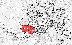
Price Hill covers a little over six square miles. It is subdivided into East Price Hill, West Price Hill, and Lower Price Hill. East Price Hill covers 3 square miles (7.8km2), West Price Hill covers 2.75 square miles (7.1km2), and Lower Price Hillcovers 0.57 square miles (1.5km2). The latter neighborhood located is in the river valley to the southwest of East Price Hill. The city police use the Mill Creek as the border between Lower Price Hill and Queensgate.
Demographics
Population of Greater Price Hill (East, West and Lower) 1900-2020[citation needed]
Year
Pop.
±%
1900
17,182
—
1910
21,825
+27.0%
1920
30,425
+39.4%
1930
42,915
+41.1%
1940
42,870
−0.1%
1950
42,935
+0.2%
1960
49,182
+14.5%
1970
46,861
−4.7%
1980
39,734
−15.2%
1990
40,859
+2.8%
2000
36,388
−10.9%
2010
33,570
−7.7%
2020
36,271
+8.0%
East Price Hill
As of the census of 2020, there were 15,241 people living in East Price Hill. There were 7,037 housing units. The racial makeup of the neighborhood was 39.4% White, 36.3% Black or African American, 0.9% Native American, 0.7% Asian, 0.0% Pacific Islander, 15.5% from some other race, and 7.2% from two or more races. 19.9% of the population were Hispanic or Latino of any race.[3]
There were 6,063 households, out of which 57.8% were families. 34.9% of all households were made up of individuals.[3]
27.0% of the neighborhood's population were under the age of 18, 57.8% were 18 to 64, and 15.2% were 65 years of age or older. 48.4% of the population were male and 51.6% were female.[3]
According to the U.S. Census American Community Survey, for the period 2016-2020 the estimated median annual income for a household in the neighborhood was $30,112. About 26.8% of family households were living below the poverty line. About 15.1% had a bachelor's degree or higher.[3]
West Price Hill
As of the census of 2020, there were 19,960 people living in West Price Hill. There were 8,962 housing units. The racial makeup of the neighborhood was 55.7% White, 30.1% Black or African American, 0.5% Native American, 0.7% Asian, 0.0% Pacific Islander, 5.3% from some other race, and 7.7% from two or more races. 8.3% of the population were Hispanic or Latino of any race.[4]
There were 8,108 households, out of which 58.3% were families. 35.5% of all households were made up of individuals.[4]
27.9% of the neighborhood's population were under the age of 18, 63.4% were 18 to 64, and 8.7% were 65 years of age or older. 47.7% of the population were male and 52.3% were female.[4]
According to the U.S. Census American Community Survey, for the period 2016-2020 the estimated median annual income for a household in the neighborhood was $44,664. About 14.5% of family households were living below the poverty line. About 22.0% had a bachelor's degree or higher.[4]
There were 369 households, out of which 42.8% were families. 41.7% of all households were made up of individuals.[5]
34.8% of the neighborhood's population were under the age of 18, 57.2% were 18 to 64, and 8.0% were 65 years of age or older. 63.1% of the population were male and 36.9% were female.[5]
According to the U.S. Census American Community Survey, for the period 2016-2020 the estimated median annual income for a household in the neighborhood was $15,987. About 66.5% of family households were living below the poverty line. About 8.7% had a bachelor's degree or higher.[5]
Mother of Mercy High School - A Catholic girls high school, not located in Price Hill but serving girls who live in the neighborhood.
Oyler School - A public school serving Kindergarten through high school.
IDEA Public School' - A public charter school currently serving K-2 (Academy), and 6-7th grades (College Prep), and will eventually be K—12.
Landmarks
Branch Hospital for Contagious Diseases From 1897, this hospital was used for housing and treating victims of tuberculosis. The hospital now forms part of the Dunham Recreation Center.[8]
Fire Company 24 Constructed in 1889, the fire station is now a private residence with a first-floor art gallery.[8]
Mount Echo Park Established in 1908, the 73-acre (30ha) park is known as the viewing platform for one of the best views of Cincinnati's skyline.[8]
Price Hill Library Finished in 1909, the library was one of the many libraries funded by Andrew Carnegie. It is now a branch of the Cincinnati and Hamilton County Public Library system.[8]
This page is based on this Wikipedia article Text is available under the CC BY-SA 4.0 license; additional terms may apply. Images, videos and audio are available under their respective licenses.