Westwood, Cincinnati

Last updated
Westwood
Westwood town hall in Cincinnati.jpg
Westwood's community center
Flag of Westwood, Cincinnati, Ohio.svg
Westwood-Cincinnati-map.jpg
Westwood (red) within Cincinnati, Ohio.
CountryUnited States
State Ohio
County Hamilton
City Cincinnati
Population
 (2020)
33,774

Westwood is one of the 52 neighborhoods of Cincinnati, Ohio. Annexed in 1896 and located in the western part of the city, it is the city's largest neighborhood in both area and population. [1] The population was 33,774 at the 2020 census. [2]

Contents

History

Westwood was incorporated as a village on 14 September 1868. It was annexed by the City of Cincinnati on 8 May 1896. [3] [4]

In the late 19th and early 20th centuries, Westwood's rural environment attracted many wealthy individuals, such as Procter & Gamble co-founder James Gamble. The neighborhood declined economically following World War II as poorer individuals moved into Westwood and wealthier residents moved to the suburbs. [5]

Historic sites

Westwood contains the Westwood Town Center Historic District.

Geography

Mural off Harrison Avenue in Westwood. Westwood Bestwood foto by andy hemmer cincinnati.jpg
Mural off Harrison Avenue in Westwood.

It is located north of Price Hill, west of Fairmount, and southwest of Mount Airy. The city of Cheviot is adjacent to Westwood's western border.

Demographics

Population of Westwood 1880-2020
YearPop.±%
1880 852    
1890 1,050+23.2%
1900 1,651+57.2%
1910 3,032+83.6%
1920 5,000+64.9%
1930 9,165+83.3%
1940 10,976+19.8%
1950 16,486+50.2%
1960 22,474+36.3%
1970 28,803+28.2%
1980 33,580+16.6%
1990 36,034+7.3%
2000 35,730−0.8%
2010 29,950−16.2%
2020 33,774+12.8%
[6] [7] [8]

As of the census of 2020, there were 33,774 people living in the neighborhood. There were 16,456 housing units. The racial makeup of the neighborhood was 36.3% White, 53.1% Black or African American, 0.3% Native American, 1.2% Asian, 0.0% Pacific Islander, 3.8% from some other race, and 5.3% from two or more races. 5.3% of the population were Hispanic or Latino of any race. [2]

There were 14,435 households, out of which 48.1% were families. About 44.0% of all households were made up of individuals. [2]

27.2% of the neighborhood's population were under the age of 18, 63.4% were 18 to 64, and 9.4% were 65 years of age or older. 48.3% of the population were male and 51.7% were female. [2]

According to the U.S. Census American Community Survey, for the period 2016-2020 the estimated median annual income for a household in the neighborhood was $36,546. About 18.7% of family households were living below the poverty line. About 23.9% of adults had a bachelor's degree or higher. [2]

Parks

Bracken Woods is an urban park in Westwood containing a nature preserve.

Notable people

Related Research Articles

<span class="mw-page-title-main">Bond Hill, Cincinnati</span> Neighborhood of Cincinnati in Hamilton, Ohio, United States

Bond Hill is one of the 52 neighborhoods of Cincinnati, Ohio. Founded as a railroad suburb and temperance community in 1870 in northeastern Millcreek Township, it is one of a number of neighborhoods lining the Mill Creek. The population was 7,002 at the 2020 census.

<span class="mw-page-title-main">Evanston, Cincinnati</span> Neighborhood of Cincinnati in Ohio, United States

Evanston is one of the 52 neighborhoods of Cincinnati, Ohio. A mostly African-American neighborhood since the 1960s, it is known as "the educating community," and is bordered by the neighborhoods of East Walnut Hills, Hyde Park, North Avondale, and Walnut Hills, as well as the City of Norwood. The population was 8,838 at the 2020 census.

<span class="mw-page-title-main">Mount Washington, Cincinnati</span> Neighborhood of Cincinnati in Hamilton, Ohio, United States

Mount Washington is one of the 52 neighborhoods of Cincinnati, Ohio, United States. It borders the neighborhoods of California and the East End, as well as Anderson Township, Hamilton County, Ohio. The population was 20,540 at the 2020 census.

<span class="mw-page-title-main">Clifton, Cincinnati</span> Neighborhood of Cincinnati in Ohio, United States

Clifton is one of the 52 neighborhoods of Cincinnati, Ohio. The population was 8,408 in the 2020 census.

<span class="mw-page-title-main">Columbia-Tusculum, Cincinnati</span> Neighborhood of Cincinnati in Hamilton, Ohio, United States

Columbia-Tusculum is one of the 52 neighborhoods of Cincinnati, Ohio. Founded in 1788 and annexed in 1871, it is the city's oldest neighborhood. The population was 1,523 at the 2020 census.

<span class="mw-page-title-main">Mount Adams, Cincinnati</span> Neighborhood of Cincinnati in Ohio, United States

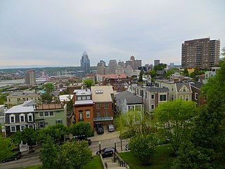
Mount Adams is one of the 52 neighborhoods of Cincinnati, Ohio. Located on a hill immediately east of downtown Cincinnati, it is south of Walnut Hills, southwest of East Walnut Hills, and west of the East End. The population was 1,578 at the 2020 census.

<span class="mw-page-title-main">Hyde Park, Cincinnati</span> Neighborhood of Cincinnati in Ohio, United States

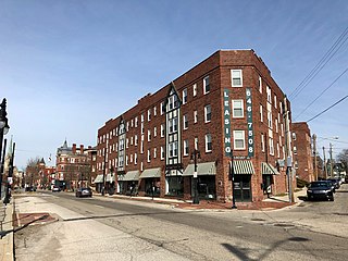
Hyde Park is one of the 52 neighborhoods of Cincinnati, Ohio. Originally established as a retreat for the city's wealthy, the neighborhood is predominately residential, with a central business district known as Hyde Park Square. The population was 14,193 at the 2020 census.

<span class="mw-page-title-main">East Walnut Hills, Cincinnati</span> Place in Ohio, United States

East Walnut Hills is one of the 52 neighborhoods of Cincinnati, Ohio. Established in 1867 and annexed in 1873, it is located in the eastern side of the city. The population was 4,103 at the 2020 census.

<span class="mw-page-title-main">Avondale, Cincinnati</span> Neighborhood of Cincinnati in Hamilton, Ohio, United States

Avondale is one of the 52 neighborhoods of Cincinnati, Ohio. It is home to the Cincinnati Zoo and Botanical Garden. The population was 11,345 at the 2020 census.

<span class="mw-page-title-main">Carthage, Cincinnati</span> Neighborhood of Cincinnati in Hamilton, Ohio, United States

Carthage is one of the 52 neighborhoods of Cincinnati, Ohio. Established in 1791 or 1792 and annexed in 1911, it is located in the northern part of the city's Mill Creek valley. The neighborhood is predominately residential, and is center of the city's Hispanic community. It shares a border with Elmwood Place, Ohio, which, with adjacent St. Bernard, Ohio, forms an enclave in the middle of Cincinnati. The population was 2,781 at the 2020 census.

<span class="mw-page-title-main">College Hill, Cincinnati</span> Neighborhood of Cincinnati in Hamilton, Ohio, United States

College Hill is one of the 52 neighborhoods of Cincinnati, Ohio. Established in 1813 and annexed in 1911, 1915, and 1923, it is located in the northwestern part of the city. It was originally called Pleasant Hill due to its prime location, but was later renamed College Hill because of the two colleges that were established there in the mid-nineteenth century. The neighborhood is not to be confused with North College Hill, which borders College Hill to the north but is not part of Cincinnati. The population was 16,039 at the 2020 census.

<span class="mw-page-title-main">Madisonville, Cincinnati</span> Neighborhood of Cincinnati in Ohio, United States

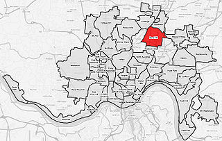
Madisonville is one of the 52 neighborhoods of Cincinnati, Ohio. Established in 1809 and annexed in 1911, it is located in the northeastern part of the city. The population was 17,898 at the 2020 census.

<span class="mw-page-title-main">Mount Airy, Cincinnati</span> Neighborhood of Cincinnati in Hamilton, Ohio, United States

Mount Airy is one of the 52 neighborhoods of Cincinnati, Ohio. The neighborhood is home to Mount Airy Forest, one of the oldest urban reforestation projects in the country. The population was 9,210 at the 2020 census.

<span class="mw-page-title-main">Pendleton, Cincinnati</span> Neighborhood of Cincinnati in Ohio, United States

Pendleton is one of the 52 neighborhoods of Cincinnati, Ohio. It is located within the city's urban basin. The population was 1,088 as of the 2020 census.

<span class="mw-page-title-main">West End, Cincinnati</span> Neighborhood of Cincinnati in Ohio, United States

West End is one of the 52 neighborhoods of Cincinnati, Ohio. Originally a large residential neighborhood, the majority of the area was demolished in the mid-20th century for the construction of highway interchanges and an industrial park known as Queensgate. The population was 6,824 at the 2020 census.

<span class="mw-page-title-main">Riverside, Cincinnati</span> Neighborhood of Cincinnati in Hamilton, Ohio, United States

Riverside is one of the 52 neighborhoods of Cincinnati, Ohio. The neighborhood is contained in a narrow strip of land along the Ohio River on the city's west side, between Sayler Park and Sedamsville. Predominately industrial, the neighborhood has few residential areas, with a population of 1,257 at the 2020 census.

<span class="mw-page-title-main">Sayler Park, Cincinnati</span> Neighborhood of Cincinnati in Hamilton, Ohio, United States

Sayler Park is one of the 52 neighborhoods of Cincinnati, Ohio. Situated along the Ohio River, it is the westernmost neighborhood in the city. The population was 2,825 at the 2020 census.

<span class="mw-page-title-main">Sedamsville, Cincinnati</span> Place in Ohio, United States

Sedamsville is one of the 52 neighborhoods of Cincinnati, Ohio. Established in 1795 and annexed in 1870, the neighborhood lies along the Ohio River in the western part of the city. The population was 1,256 at the 2020 census.

<span class="mw-page-title-main">Downtown Cincinnati</span> Neighborhood in Cincinnati, Ohio, United States

Downtown Cincinnati is one of the 52 neighborhoods of Cincinnati, Ohio. It is the central business district of the city, as well the economic and symbiotic center of the Cincinnati metropolitan area. Originally the densely populated core of the city, the neighborhood was transformed into a commercial zone in the mid-20th century. The population was 5,835 at the 2020 census.

<span class="mw-page-title-main">Hartwell, Cincinnati</span> Neighborhood of Cincinnati in Hamilton, Ohio, United States

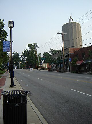
Hartwell is one of the 52 neighborhoods of Cincinnati, Ohio. Established in 1868 and annexed in 1912, it is the city's northernmost neighborhood, centered roughly on the intersections of I-75 and Ronald Reagan Cross County Highway. Its boundaries are a combination of Caldwell Park and Ronald Reagan Cross County Highway to the south, I-75 to the east, and a combination of Millsdale Street and Compton Road to the North. The population was 5,806 at the 2020 census.

References

  1. "Neighborhoods". Cincinnati magazine. Retrieved 25 July 2014.
  2. 1 2 3 4 5 "Westwood 2020 Statistical Neighborhood Approximation" (PDF). City of Cincinnati. Retrieved 2 January 2024.
  3. Clarke, S. J. (1912). "Cincinnati, the Queen City, 1788-1912, Volume 2". The S. J. Clarke Publishing Company. p. 528. Retrieved 2013-05-20.
  4. Federal Writers' Project (1943). Cincinnati: A Guide to the Queen City and its Neighbors. The City of Cincinnati, Ohio. p. 570. ISBN   9781603540513 . Retrieved 2014-05-07.
  5. Schultz, Kevin (January 10, 2019). "Westwood Is On The Rise". Cincinnati Magazine. Retrieved December 17, 2021.
  6. Quinn, James; Eubank, Earle; Elliott, Lois (1947). Population changes--Cincinnati, Ohio, and adjacent areas 1900- 1940. Bureau of Business Research, the Ohio State Univ. in co-operation with the City of Cincinnati, and the Dept. of Sociology.
  7. Enquirer, Cincinnati. "A neighborhood comparison: Population (2020)". The Enquirer. USA Today. Retrieved 16 February 2024.
  8. Census, US. "Population Publications (1790-2020)". US Census. Retrieved 16 February 2024.

Further reading

39°08′46″N84°35′22″W / 39.1461111°N 84.5894444°W / 39.1461111; -84.5894444