Sayler Park, Cincinnati

Last updated
Sayler Park
Ohio river at Fernbank park.jpeg
The Ohio River as seen from Fernbank Park in Sayler Park Ohio
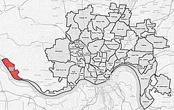
Flag of Sayler Park, Cincinnati, Ohio.svg
Sayler-Park-Cincinnati-map.jpg
Sayler Park(red) within Cincinnati, Ohio
Country United States
State Ohio
County Hamilton
City Cincinnati
Population
 (2020)
  Total2,825

Sayler Park is one of the 52 neighborhoods of Cincinnati, Ohio. [1] Situated along the Ohio River, it is the westernmost neighborhood in the city. The population was 2,825 at the 2020 census. [2]

Contents

History

Sayler Park was originally known as Home City. [3] Sayler Park was annexed by the City of Cincinnati in 1911. [4] The neighborhood was struck by a F5 tornado in 1974 during the Super Outbreak, killing three people and destroying several homes. [5]

Demographics

Population of Sayler Park 1900-2020
YearPop.±%
1900 2,000    
1910 2,013+0.6%
1920 2,075+3.1%
1930 2,352+13.3%
1940 2,627+11.7%
1950 2,990+13.8%
1960 3,165+5.9%
1970 3,430+8.4%
1980 3,384−1.3%
1990 3,516+3.9%
2000 3,233−8.0%
2010 2,765−14.5%
2020 2,825+2.2%
[ citation needed ]

As of the census of 2020, there were 2,825 people living in the neighborhood. There were 1,312 housing units. The racial makeup of the neighborhood was 86.8% White, 5.6% Black or African American, 0.2% Native American, 0.3% Asian, 0.0% Pacific Islander, 0.7% from some other race, and 6.4% from two or more races. 2.1% of the population were Hispanic or Latino of any race. [2]

There were 1,193 households, out of which 73.0% were families. 24.0% of all households were made up of individuals. [2]

23.6% of the neighborhood's population were under the age of 18, 60.3% were 18 to 64, and 16.1% were 65 years of age or older. 49.4% of the population were male and 50.6% were female. [2]

According to the U.S. Census American Community Survey, for the period 2016-2020 the estimated median annual income for a household in the neighborhood was $56,918. About 14.7% of family households were living below the poverty line. About 23.8% of adults had a bachelor's degree or higher. [2]

Parks

Gateway feature off U.S. Route 50 (River Road) for Sayler Park. Sayler Park Ohio gateway foto by andy hemmer cincinnati.jpg
Gateway feature off U.S. Route 50 (River Road) for Sayler Park.

The 65-acre (26 ha) Fernbank Park in Sayler Park stretches over a mile along the Ohio River. [6] The Thornton Triangle is Cincinnati's smallest municipal park. [7]

Related Research Articles

<span class="mw-page-title-main">Montgomery, Ohio</span> City in Ohio, United States

Montgomery is a city in Hamilton County, Ohio, United States. It is an eastern suburb of Cincinnati. The population was 10,853 at the 2020 census.

<span class="mw-page-title-main">Evanston, Cincinnati</span> Neighborhood of Cincinnati in Ohio, United States

Evanston is one of the 52 neighborhoods of Cincinnati, Ohio. A mostly African-American neighborhood since the 1960s, it is known as "the educating community," and is bordered by the neighborhoods of East Walnut Hills, Hyde Park, North Avondale, and Walnut Hills, as well as the City of Norwood. The population was 8,838 at the 2020 census.

<span class="mw-page-title-main">Mount Washington, Cincinnati</span> Neighborhood of Cincinnati in Hamilton, Ohio, United States

Mount Washington is one of the 52 neighborhoods of Cincinnati, Ohio, United States.. It borders the neighborhoods of California and the East End, as well as Anderson Township, Hamilton County, Ohio. The population was 20,540 at the 2020 census.

<span class="mw-page-title-main">Clifton, Cincinnati</span> Neighborhood of Cincinnati in Ohio, United States

Clifton is is one of the 52 neighborhoods of Cincinnati, Ohio. The population was 8,408 in the 2020 census.

<span class="mw-page-title-main">California, Cincinnati</span> Neighborhood of Cincinnati in Ohio, United States

California, Cincinnati is one of the 52 neighborhoods of Cincinnati, Ohio. Located at the confluence of the Little Miami River and Ohio River, it is the southeastern-most neighborhood in the city. California borders the Cincinnati neighborhoods of Mt. Washington and the East End, as well as Anderson Township. The population was 944 at the 2020 census.

<span class="mw-page-title-main">Columbia-Tusculum, Cincinnati</span> Neighborhood of Cincinnati in Hamilton, Ohio, United States

Columbia-Tusculum is one of the 52 neighborhoods of Cincinnati, Ohio. Founded in 1788 and annexed in 1871, it is the city's oldest neighborhood. The population was 1,523 at the 2020 census.

<span class="mw-page-title-main">Hyde Park, Cincinnati</span> Neighborhood of Cincinnati in Ohio, United States

Hyde Park is one of the 52 neighborhoods of Cincinnati, Ohio. Originally established as a retreat for the city's wealthy, the neighborhood is predominately residential, with a central business district known as Hyde Park Square. The population was 14,193 at the 2020 census.

<span class="mw-page-title-main">Westwood, Cincinnati</span> Neighborhood of Cincinnati in Hamilton, Ohio, United States

Westwood is one of the 52 neighborhoods of Cincinnati, Ohio. Annexed in 1896 and located in the western part of the city, it is the city's largest neighborhood in both area and population. The population was 33,774 at the 2020 census.

<span class="mw-page-title-main">Camp Washington, Cincinnati</span> Neighborhood of Cincinnati in Ohio, United States

Camp Washington is a neighborhood of Cincinnati, Ohio, United States. Located next to the Mill Creek, it is north of Queensgate, east of Fairmount, and west of Clifton and University Heights. The community is a crossing of 19th-century homes and industrial space The population was 1,234 at the 2020 census.

<span class="mw-page-title-main">Carthage, Cincinnati</span> Neighborhood of Cincinnati in Hamilton, Ohio, United States

Carthage is one of the 52 neighborhoods of Cincinnati, Ohio. Established in 1791 or 1792 and annexed in 1911, it is located in the northern part of the city's Mill Creek valley. The neighborhood is predominately residential, and is center of the city's Hispanic community. It shares a border with Elmwood Place, Ohio, which, with adjacent St. Bernard, Ohio, forms an enclave in the middle of Cincinnati. The population was 2,781 at the 2020 census.

<span class="mw-page-title-main">Kennedy Heights, Cincinnati</span> Neighborhood of Cincinnati in Hamilton, Ohio, United States

Kennedy Heights is one of the 52 neighborhoods of Cincinnati, Ohio. The population was 5,166 at the 2020 census.

<span class="mw-page-title-main">CUF, Cincinnati</span> Neighborhood

CUF is one of the 52 neighborhoods of Cincinnati, Ohio. Its name is derived from the communities of Clifton Heights, University Heights, and Fairview. These communities surround the University of Cincinnati to the south and west of its main campus, making CUF a predominantly residential, student neighborhood. The population was 20,385 at the 2020 census.

<span class="mw-page-title-main">Corryville, Cincinnati</span> Neighborhood of Cincinnati in Ohio, United States

Corryville is one of the 52 neighborhoods of Cincinnati, Ohio. It is located immediately east of the University of Cincinnati, southeast of Clifton, south and west of Avondale, northwest of Walnut Hills, and north of Mount Auburn. The population was 4,373 at the 2020 census.

<span class="mw-page-title-main">East End, Cincinnati</span> Neighborhood of Cincinnati in Hamilton, Ohio, United States

East End is one of the 52 neighborhoods of Cincinnati, Ohio. The neighborhood, a 7-mile (11 km) strip along the Ohio River, once held Cincinnati's manufacturing district. It is the location of the Cincinnati Municipal Lunken Airport and Columbia Parkway. The population was 1,476 at the 2020 census.

<span class="mw-page-title-main">Linwood, Cincinnati</span> Neighborhood of Cincinnati in Hamilton, Ohio, United States

Linwood is one of the 52 neighborhoods of Cincinnati, Ohio, United States. Annexed in 1893, it is located in the eastern part of the city. The population was 705 at the 2020 census.

<span class="mw-page-title-main">Madisonville, Cincinnati</span> Neighborhood of Cincinnati in Ohio, United States

Madisonville is one of the 52 neighborhoods of Cincinnati, Ohio. Established in 1809 and annexed in 1911, it is located in the northeastern part of the city. The population was 17,898 at the 2020 census.

<span class="mw-page-title-main">Mount Airy, Cincinnati</span> Neighborhood of Cincinnati in Hamilton, Ohio, United States

Mount Airy is one of the 52 neighborhoods of Cincinnati, Ohio. The neighborhood is home to Mount Airy Forest, one of the oldest urban reforestation projects in the country. The population was 9,210 at the 2020 census.

<span class="mw-page-title-main">Walnut Hills, Cincinnati</span> Neighborhood of Cincinnati in Ohio, United States

Walnut Hills is one of the 52 neighborhoods of Cincinnati, Ohio. One of the city's oldest hilltop neighborhoods, it is a large diverse area on the near east side of Cincinnati. The population was 6,344 in the 2020 census.

<span class="mw-page-title-main">Riverside, Cincinnati</span> Neighborhood of Cincinnati in Hamilton, Ohio, United States

Riverside is one of the 52 neighborhoods of Cincinnati, Ohio. The neighborhood is contained in a narrow strip of land along the Ohio River on the city's west side, between Sayler Park and Sedamsville. Predominately industrial, the neighborhood has few residential areas, with a population of 1,257 at the 2020 census.

<span class="mw-page-title-main">Hartwell, Cincinnati</span> Neighborhood of Cincinnati in Hamilton, Ohio, United States

Hartwell is one of the 52 neighborhoods of Cincinnati, Ohio. Established in 1868 and annexed in 1912, it is the city's northernmost neighborhood, centered roughly on the intersections of I-75 and Ronald Reagan Cross County Highway. Its boundaries are a combination of Caldwell Park and Ronald Reagan Cross County Highway to the south, I-75 to the east, and a combination of Millsdale Street and Compton Road to the North. The population was 5,806 at the 2020 census.

References

  1. U.S. Geological Survey Geographic Names Information System: Sayler Park
  2. 1 2 3 4 5 "Sayler Park 2020 Statistical Neighborhood Approximation" (PDF). City of Cincinnati. Retrieved 30 December 2023.
  3. Hand, Greg (November 20, 2017). "From Bucktown To Vanceville: Cincinnati's Lost 19th Century Neighborhoods". Cincinnati . Retrieved July 8, 2019.
  4. Clarke, S. J. (1912). Cincinnati, the Queen City, 1788-1912, Volume 2. The S. J. Clarke Publishing Company. p. 528. Retrieved 2013-05-20.
  5. Horstmeyer, Steve (Dec 1995). "It's Not the Heat, It's The..." Cincinnati Magazine. p. 66. Retrieved 2013-05-18.
  6. "Fernbank Park". Cincinnati Park Board. Retrieved 2013-12-26.
  7. "Cinciparks". cincinnatiparks.com. Retrieved 2014-06-08.

39°06′45″N84°41′21″W / 39.1125°N 84.6891667°W / 39.1125; -84.6891667