Lorain County, Ohio

Last updated

Lorain County
Elyria-ohio-old-county-building.jpg
Old county building in Elyria
Lorain County, Ohio Flag.gif
Seal of Lorain County Ohio.svg
Map of Ohio highlighting Lorain County.svg
Location within the U.S. state of Ohio
Ohio in United States.svg
Ohio's location within the U.S.
Coordinates: 41°28′N82°09′W / 41.47°N 82.15°W / 41.47; -82.15
CountryFlag of the United States.svg United States
StateFlag of Ohio.svg  Ohio
FoundedApril 1, 1824
Named for Lorraine in France [1]
Seat Elyria
Largest city Lorain
Area
  Total923 sq mi (2,390 km2)
  Land491 sq mi (1,270 km2)
  Water432 sq mi (1,120 km2)  47%
Population
 (2020)
  Total312,964
  Estimate 
(2021)
315,595 Increase2.svg
  Density340/sq mi (130/km2)
Congressional district 5th
Website www.loraincounty.us

Lorain County is a county in the northeastern part of the U.S. state of Ohio As of the 2020 census, the population was 312,964. [2] Its county seat is Elyria, and its largest city is Lorain. [3]

Contents

The county was physically established in 1822, becoming judicially independent in 1824. [4] Lorain County is part of the Cleveland, OH Metropolitan Statistical Area. The county is home to Oberlin College.

History

Lorain County was established in 1822 from portions of several of its adjacent counties. [5] This county became judicially-independent in 1824. The original proposed name for the county was "Colerain". [6] The final name "Lorain" was chosen by Heman Ely, who had previously founded and named the city of Elyria. The county's name is based on the former German and now French province of Lorraine. [7]

Geography

According to the United States Census Bureau, the county has an area of 923 square miles (2,390 km2), of which 491 square miles (1,270 km2) is land and 432 square miles (1,120 km2) (47%) is water. [8] It is Ohio's fourth-largest county by area.

Adjacent counties

Major highways

Demographics

Historical population
CensusPop.Note
1830 5,696
1840 18,467224.2%
1850 26,08641.3%
1860 29,74414.0%
1870 30,3081.9%
1880 35,52617.2%
1890 40,29513.4%
1900 54,85736.1%
1910 76,03738.6%
1920 90,61219.2%
1930 109,20620.5%
1940 112,3902.9%
1950 148,16231.8%
1960 217,50046.8%
1970 256,84318.1%
1980 274,9097.0%
1990 271,126−1.4%
2000 284,6645.0%
2010 301,3565.9%
2020 312,9643.9%
2023 (est.)317,910 [9] 1.6%
U.S. Decennial Census [10]
1790-1960 [11] 1900-1990 [12]
1990-2000 [13] 2010-2020 [2]

As of the 2010 census, there were 301,356 people, 116,274 households, and 80,077 families residing in the county. [14] The population density was 613.6 inhabitants per square mile (236.9/km2). There were 127,036 housing units at an average density of 258.7 per square mile (99.9/km2). [15] The racial makeup of the county was 84.8% white, 8.6% black or African American, 0.9% Asian, 0.3% American Indian, 2.5% from other races, and 3.0% from two or more races. Those of Hispanic or Latino origin made up 8.4% of the population. [14] In terms of ancestry, 26.5% were German, 16.7% were Irish, 10.9% were English, 8.4% were Polish, 8.2% were Italian, 6.2% were American, and 5.2% were Hungarian. [16]

Of the 116,274 households, 32.6% had children under the age of 18 living with them, 50.5% were married couples living together, 13.5% had a female householder with no husband present, 31.1% were non-families, and 26.0% of all households were made up of individuals. The average household size was 2.51 and the average family size was 3.02. The median age was 40.0 years. [14]

The median income for a household in the county was $52,066 and the median income for a family was $62,082. Males had a median income of $49,146 versus $35,334 for females. The per capita income for the county was $25,002. About 10.3% of families and 13.1% of the population were below the poverty line, including 20.5% of those under age 18 and 8.0% of those age 65 or over. [17]

Education

Higher education

Public school districts

There are 20 public school districts in Lorain County. Those primarily in Lorain County are listed in bold. Each district's high school(s) and location is also listed.

The county also includes the Lorain County Joint Vocational School District, which encompasses the entire county and serves students from the Amherst, Avon, Avon Lake, Clearview, Columbia, Elyria, Firelands, Keystone, Midview, North Ridgeville, Oberlin, Sheffield-Sheffield Lake and Wellington school districts from a 10-acre campus on a 100-acre site near the intersection of State Route 58 and U.S. Route 20 in Oberlin. [18]

Private high schools

Politics

Lorain County used to lean Democratic in recent presidential elections, voting for the Democratic candidate for president in 12 of the last 16 elections, including a winning streak that lasted from 1988 to 2016. In 2016, however, the county was almost swept up as part of the unexpected Republican surge in the Rust Belt; Donald Trump came within 131 votes of being the first Republican to capture the county since Ronald Reagan in 1984. Four years later, he flipped the county Republican by a narrow majority.

United States presidential election results for Lorain County, Ohio [19]
Year Republican Democratic Third party
No.%No.%No.%
2020 79,52050.40%75,66747.96%2,5811.64%
2016 66,81847.54%66,94947.63%6,7954.83%
2012 59,40541.47%81,46456.87%2,3841.66%
2008 59,06840.22%85,27658.07%2,5151.71%
2004 61,20343.49%78,97056.11%5690.40%
2000 47,95742.75%59,80953.32%4,4143.93%
1996 34,93732.82%55,74452.37%15,76414.81%
1992 36,80331.03%50,96242.97%30,84026.00%
1988 50,41047.14%55,60052.00%9160.86%
1984 57,37950.77%52,97046.87%2,6722.36%
1980 51,03449.51%40,91939.69%11,13110.80%
1976 39,45941.66%52,38755.31%2,8653.02%
1972 51,10256.15%36,63440.25%3,2803.60%
1968 34,25239.95%42,64249.74%8,83310.30%
1964 26,68332.37%55,75567.63%00.00%
1960 39,36147.51%43,48752.49%00.00%
1956 40,34060.11%26,77439.89%00.00%
1952 33,82556.36%26,19443.64%00.00%
1948 21,61649.53%21,39749.03%6251.43%
1944 23,86648.59%25,25451.41%00.00%
1940 23,42247.55%25,83152.45%00.00%
1936 15,90637.29%24,39357.19%2,3575.53%
1932 20,89751.00%18,75345.77%1,3213.22%
1928 24,38663.83%13,60735.62%2120.55%
1924 17,06261.43%3,96514.28%6,74724.29%
1920 18,12565.84%8,64031.39%7642.78%
1916 6,86845.66%7,65850.91%5163.43%
1912 2,22616.34%4,59133.71%6,80449.95%
1908 8,69957.10%5,46035.84%1,0767.06%
1904 9,00170.16%2,70021.04%1,1298.80%
1900 8,49761.93%4,98936.36%2351.71%
1896 7,80163.28%4,36735.43%1591.29%
1892 5,43456.60%3,67438.27%4925.13%
1888 5,23557.32%3,31136.25%5876.43%
1884 5,47860.30%3,19935.21%4084.49%
1880 5,60966.25%2,75232.51%1051.24%
1876 5,18765.28%2,72034.23%390.49%
1872 4,43267.71%2,09732.03%170.26%
1868 4,44369.72%1,93030.28%00.00%
1864 4,60073.65%1,64626.35%00.00%
1860 4,04566.89%1,76629.20%2363.90%
1856 3,60470.97%1,42027.96%541.06%

Communities

Map of Lorain County, Ohio With Municipal and Township Labels Map of Lorain County Ohio With Municipal and Township Labels.PNG
Map of Lorain County, Ohio With Municipal and Township Labels

Cities

Villages

Townships

Census-designated places

Unincorporated communities

See also

Related Research Articles

<span class="mw-page-title-main">Eaton Estates, Ohio</span> Census-designated place in Ohio, United States

Eaton Estates is an unincorporated community and census-designated place (CDP) in Lorain County, Ohio, United States. The population was 1,155 at the 2020 census.
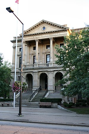
<span class="mw-page-title-main">Lorain, Ohio</span> City in Ohio, United States

Lorain is a city in Lorain County, Ohio, United States. It is located in Northeast Ohio on Lake Erie at the mouth of the Black River, about 25 miles (40 km) miles west of Cleveland. As of the 2020 census, the city had a population of 65,211, making it Ohio's ninth-largest city, the third-largest in Greater Cleveland, and the largest in Lorain County by population.

<span class="mw-page-title-main">North Ridgeville, Ohio</span> City in Ohio, United States

North Ridgeville is a city located along the eastern border of Lorain County, Ohio, United States. The city's population was 35,280 as of the 2020 census. A part of the Cleveland metropolitan area, North Ridgeville is the fastest-growing city in northern Ohio. It has been ranked the 13th safest city in the United States and the safest in Ohio.

<span class="mw-page-title-main">Oberlin, Ohio</span> City in Lorain County, Ohio, United States

Oberlin is a city in Lorain County, Ohio, United States. It is located about 31 miles (50 km) southwest of Cleveland within the Cleveland metropolitan area. The population was 8,555 at the 2020 census. Oberlin is the home of Oberlin College, a liberal arts college and music conservatory with approximately 3,000 students.

<span class="mw-page-title-main">Greater Cleveland</span> Metropolitan Statistical Area in Ohio, United States

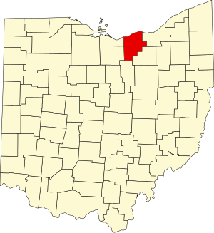
The Cleveland metropolitan area, or Greater Cleveland as it is more commonly known, is the metropolitan area surrounding the city of Cleveland in Northeast Ohio, United States. According to the 2020 census results, the six-county Cleveland, OH Metropolitan Statistical Area (MSA) consists of Cuyahoga County, Ashtabula County, Geauga County, Lake County, Lorain County, and Medina County, and has a population of 2,185,825, making it the 33rd-most populous metropolitan area in the United States and the third largest metropolitan area in Ohio. The metro area is also part of the larger Cleveland–Akron–Canton Combined Statistical Area with a population of over 3.7 million people, the most populous statistical area in Ohio and the 17th most populous in the United States.

<span class="mw-page-title-main">Columbia Township, Lorain County, Ohio</span> Township in Ohio, United States

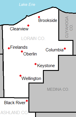
Columbia Township, also known as Columbia Station or just Columbia, is the easternmost of the eighteen townships of Lorain County, Ohio, United States. Columbia Township is the official government name, while Columbia Station is the post office name, and tends to be the town name used by residents. The post office name was chosen to differentiate the township from other Columbia Townships statewide, located in Hamilton and Meigs counties.

Ohio's 5th congressional district is in northwestern and north central Ohio and borders Indiana. The district is currently represented by Republican Bob Latta.

<span class="mw-page-title-main">West Shore Conference</span> Defunct high school athletic league in Ohio, USA

The West Shore Conference was a high school athletic conference located in northeast Ohio, with member schools stretched across Cuyahoga, Erie, and Lorain counties.

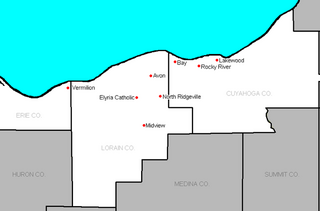
The Southwestern Conference is a high school athletic league whose members are located in Cuyahoga and Lorain counties, mainly southwest of the city of Cleveland. The league was formed in 1937 and is part of the Ohio High School Athletic Association (OHSAA).

<span class="mw-page-title-main">Clearview High School</span> High school in Lorain, Ohio, United States

Clearview High School (CHS) is a public high school located in Lorain, Ohio, United States. It is part of the Clearview Local School District, one of five school districts serving the city of Lorain and all of Sheffield Township, Ohio. Clearview High School houses students in grades 9-12. It was formerly named Clearview Junior-Senior High School and housed students in grades 7-12. After a remodeling project across the district in the early 2000s, grades 7 and 8 moved to Durling Middle School, just northwest of the high school.

Firelands High School is a public high school in Oberlin, Ohio in the United States.

<span class="mw-page-title-main">Eaton Township, Lorain County, Ohio</span> Township in Ohio, United States

Eaton Township is one of the eighteen townships of Lorain County, Ohio, United States. As of the 2020 census, the population was 5,828.

The Patriot Athletic Conference (PAC-12) was an Ohio high school athletic league made up of 12 schools from around the Cleveland area that existed from 2005-2006 to the 2018-2019 school year. All member schools were also members of the Ohio High School Athletic Association.

This is a list of high school athletic conferences in the Northeast Region of Ohio, as defined by the OHSAA. Because the names of localities and their corresponding high schools do not always match and because there is often a possibility of ambiguity with respect to either the name of a locality or the name of a high school, the following table gives both in every case, with the locality name first, in plain type, and the high school name second in boldface type. The school's team nickname is given last.

This is a list of former high school athletic conferences in the Northeast Region of Ohio, as designated by the OHSAA. If a conference had members that span multiple regions, the conference is placed in the article of the region most of its former members hail from. Because the names of localities and their corresponding high schools do not always match and because there is often a possibility of ambiguity with respect to either the name of a locality or the name of a high school, the following table gives both in every case, with the locality name first, in plain type, and the high school name second in boldface type. The school's team nickname is given last.

<span class="mw-page-title-main">North Coast Inland Trail</span> Trail project in Ohio, United States

The North Coast Inland Trail is a work-in-process multipurpose trail project that currently consists of several separate portions, defined by their counties, in northern Ohio, United States. Affiliates with the trails have high hopes to connect all of these portions and to extend the trails into Indiana and Pennsylvania, two of Ohio's land-bordering states.

Lorain County Joint Vocational School is a public vocational school in Oberlin, Ohio. LCJVS primarily serves 13 school districts located in Lorain County, with parts of Erie and Huron counties also covered.

<span class="mw-page-title-main">Lorain County League</span>

The Lorain County League (LC8) is an Ohio high school athletic league that began with the 2019-20 school year and is made up of eight schools predominantly based in Lorain County, Ohio. All schools are members of the Ohio High School Athletic Association. Previous versions of a Lorain County League existed from 1924–61 and again from 1968-2005.

References

  1. Gannett, Henry (1905). The Origin of Certain Place Names in the United States. U.S. Government Printing Office. p.  190.
  2. 1 2 "State & County QuickFacts". United States Census Bureau. Retrieved July 7, 2022.
  3. "Find a County". National Association of Counties. Retrieved June 7, 2011.
  4. "Ohio: Individual County Chronologies". Ohio Atlas of Historical County Boundaries. The Newberry Library. 2007. Archived from the original on April 6, 2016. Retrieved February 14, 2015.
  5. "Lorain County - Ohio History Central". ohiohistorycentral.org. Ohio History Connection. Retrieved October 26, 2022.
  6. Sandusky Register (newspaper); Sandusky, Ohio, 1822
  7. Wright, George Frederick (1916). A Standard History of Lorain County, Ohio: An Authentic Narrative of the Past, with Particular Attention to the Modern Era in the Commercial, Industrial, Civic and Social Development. A Chronicle of the People, with Family Lineage and Memoirs. Lewis publishing Company. pp. 625–627.
  8. "2010 Census Gazetteer Files". United States Census Bureau. August 22, 2012. Archived from the original on May 4, 2014. Retrieved February 8, 2015.
  9. "Annual Estimates of the Resident Population for Counties: April 1, 2020 to July 1, 2021" . Retrieved July 7, 2022.
  10. "U.S. Decennial Census". United States Census Bureau. Retrieved February 8, 2015.
  11. "Historical Census Browser". University of Virginia Library. Retrieved February 8, 2015.
  12. Forstall, Richard L., ed. (March 27, 1995). "Population of Counties by Decennial Census: 1900 to 1990". United States Census Bureau. Retrieved February 8, 2015.
  13. "Census 2000 PHC-T-4. Ranking Tables for Counties: 1990 and 2000" (PDF). United States Census Bureau. April 2, 2001. Archived (PDF) from the original on March 27, 2010. Retrieved February 8, 2015.
  14. 1 2 3 "DP-1 Profile of General Population and Housing Characteristics: 2010 Demographic Profile Data". United States Census Bureau. Archived from the original on February 13, 2020. Retrieved December 27, 2015.
  15. "Population, Housing Units, Area, and Density: 2010 - County". United States Census Bureau. Archived from the original on February 13, 2020. Retrieved December 27, 2015.
  16. "DP02 SELECTED SOCIAL CHARACTERISTICS IN THE UNITED STATES – 2006-2010 American Community Survey 5-Year Estimates". United States Census Bureau. Archived from the original on February 13, 2020. Retrieved December 27, 2015.
  17. "DP03 SELECTED ECONOMIC CHARACTERISTICS – 2006-2010 American Community Survey 5-Year Estimates". United States Census Bureau. Archived from the original on February 13, 2020. Retrieved December 27, 2015.
  18. JVS. "Lorain County JVS - About the Lorain County JVS". www.lcjvs.com. Archived from the original on December 22, 2011. Retrieved April 7, 2018.
  19. Leip, David. "Dave Leip's Atlas of U.S. Presidential Elections". uselectionatlas.org. Retrieved April 7, 2018.

41°28′N82°09′W / 41.47°N 82.15°W / 41.47; -82.15