North Ridgeville, Ohio | |
|---|---|
City | |
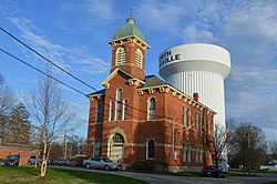 Former city hall on Center Ridge Road | |
 Interactive map of North Ridgeville, Ohio | |
 North Ridgeville  North Ridgeville | |
| Coordinates: 41°23′06″N82°01′10″W / 41.38500°N 82.01944°W | |
| Country | United States |
| State | Ohio |
| County | Lorain |
| Area | |
• Total | 23.60 sq mi (61.12 km2) |
| • Land | 23.44 sq mi (60.72 km2) |
| • Water | 0.15 sq mi (0.40 km2) |
| Elevation | 725 ft (221 m) |
| Population (2020) | |
• Total | 35,280 |
| • Density | 1,505.0/sq mi (581.07/km2) |
| Time zone | UTC-5 (Eastern (EST)) |
| • Summer (DST) | UTC-4 (EDT) |
| ZIP codes | 44039 |
| Area code | 440 |
| FIPS code | 39-56966 [3] |
| GNIS feature ID | 1086515 [2] |
| Website | www |
North Ridgeville is a city located along the eastern border of Lorain County, Ohio, United States. The city's population was 35,280 as of the 2020 census. A part of the Cleveland metropolitan area, North Ridgeville is the fastest-growing city in northern Ohio. [4] It has been ranked the 13th safest city in the United States and the safest in Ohio. [5]
Contents
- History
- Geography
- Demographics
- 2010 census
- 2000 census
- Arts and culture
- Parks and recreation
- Education
- Public schools
- Private schools
- Higher education
- Transportation
- Notable people
- References
- External links
Located 8 miles (13 km) from Cleveland Hopkins International Airport, and 18 miles (29 km) west of downtown Cleveland, North Ridgeville is the third-largest city in Lorain County and the 37th most populous city in Ohio. North Ridgeville is home to a 350,000 square foot Riddell Sports Group production and distribution center, where National Football League and NCAA helmets and pads are produced. It is also home to a campus of Lorain County Community College and a branch of University Hospitals Cleveland Medical Center.


