Kettering, Ohio

Last updated

Kettering, Ohio
Frazefountains.jpg
Flag of Kettering, Ohio.svg
Kettlogo.gif
Motto: 
"Live Work Play"
Montgomery County Ohio incorporated and unincorporated areas Kettering highlighted.svg
Location in Montgomery County and the state of Ohio
Coordinates: 39°41′47″N84°07′55″W / 39.69639°N 84.13194°W / 39.69639; -84.13194
CountryUnited States
State Ohio
Counties Montgomery
Government
   Mayor Peggy Lehner (R)
Area
[1]
  Total18.75 sq mi (48.56 km2)
  Land18.71 sq mi (48.47 km2)
  Water0.04 sq mi (0.09 km2)
Elevation
[2]
1,007 ft (307 m)
Population
 (2020)
  Total57,862
  Density3,091.74/sq mi (1,193.73/km2)
Time zone UTC−5 (Eastern (EST))
  Summer (DST) UTC−4 (EDT)
ZIP codes
45409, 45419, 45420, 45429, 45430, 45432, 45439, 45440, 45459
Area codes 937, 326
FIPS code 39-40040 [3]
GNIS feature ID1086672 [2]
Website https://www.ketteringoh.org/

Kettering is a city in Montgomery County, Ohio, United States. It is an inner suburb of Dayton. As of the 2020 census, the city had a population of 57,862, making it the most populous suburb in the Dayton metropolitan area. [4]

Contents

History

The area where the city of Kettering now lies was settled from the late 1700s to the mid-1800s, largely as farmland. The population in the area started to grow, prompting the creation of (now defunct) Van Buren Township in 1841. In November 1952, township voters approved incorporating as the Village of Kettering. (In 1953, the western portion of the village voted to secede, forming a new township, which is now the City of Moraine). [5] By 1955, the village's population had grown to 38,118, which qualified it to claim city status, with the official proclamation by the state on June 24. [6] The city is named for inventor Charles F. Kettering, who resided here in his home, Ridgeleigh Terrace, from 1914 until his death in 1958. Charles Kettering is known for his numerous inventions and contributions to Metro Dayton. [7]

From the 1950s to the 1970s, Kettering's population continued to grow, adding more than 30,000 residents. This growth was due in part to the many people who started migrating out of nearby Dayton after World War II. Since the 1980s, Kettering has experienced a slow decline in population due to an aging population and loss of manufacturing jobs.

Geography

Aerial view centered on Kettering Fairmont High School Kettering Fairmont High School.jpg
Aerial view centered on Kettering Fairmont High School

According to the United States Census Bureau, the city has a total area of 16.42 square miles (42.53 km2), of which 18.68 square miles (48.38 km2) is land and 0.04 square miles (0.10 km2) is water. [8]

The city is bordered by Dayton, Riverside, and Oakwood to the north; West Carrollton and Moraine to the west; Miami Township to the southwest; Centerville and Washington Township to the south; and Beavercreek and Sugarcreek Township to the east.

Demographics

Historical population
CensusPop.Note
1960 54,462
1970 69,59927.8%
1980 61,223−12.0%
1990 60,569−1.1%
2000 57,502−5.1%
2010 56,163−2.3%
2020 57,8623.0%
Sources: [3] [9] [10] [11]

2010 census

As of the census [12] of 2010, there were 56,163 people, 25,427 households, and 14,979 families living in the city. The population density was 3,006.6 inhabitants per square mile (1,160.9/km2). There were 27,602 housing units at an average density of 1,477.6 per square mile (570.5/km2). The racial makeup of the city was 92.6% White, 3.3% African American, 0.2% Native American, 1.3% Asian, 0.5% from other races, and 2.1% from two or more races. Hispanic or Latino of any race were 2.1% of the population.

There were 25,427 households, of which 26.3% had children under the age of 18 living with them, 43.4% were married couples living together, 11.3% had a female householder with no husband present, 4.3% had a male householder with no wife present, and 41.1% were non-families. 34.9% of all households were made up of individuals, and 13.1% had someone living alone who was 65 years of age or older. The average household size was 2.19 and the average family size was 2.83.

The median age in the city was 40.9 years. 21% of residents were under the age of 18; 8.4% were between the ages of 18 and 24; 25.6% were from 25 to 44; 27% were from 45 to 64; and 18% were 65 years of age or older. The gender makeup of the city was 47.7% male and 52.3% female.

2000 census

As of the census [3] of 2000, there were 57,502 people, 25,657 households, and 15,727 families living in the city. The population density was 3,077.4 inhabitants per square mile (1,188.2/km2). There were 26,936 housing units at an average density of 1,441.6 per square mile (556.6/km2). The racial makeup of the city was 95.23% White, 1.66% African American, 0.18% Native American, 1.38% Asian, 0.02% Pacific Islander, 0.33% from other races, and 1.19% from two or more races. Hispanic or Latino of any race were 1.11% of the population.

There were 25,657 households, out of which 26.9% had children under the age of 18 living with them, 48.7% were married couples living together, 9.5% have a single female householder, and 38.7% were non-families. 33.4% of all households were made up of individuals, and 12.7% had someone living alone who was 65 years of age or older. The average household size was 2.22 and the average family size was 2.85.

In the city, the population was spread out, with 22.5% under the age of 18, 7.5% from 18 to 24, 29.4% from 25 to 44, 22.3% from 45 to 64, and 18.3% who were 65 years of age or older. The median age was 39 years. For every 100 females, there were 90.5 males. For every 100 females age 18 and over, there were 86.7 males.

The median income for a household in the city was $45,051, and the median income for a family was $55,849. Males had a median income of $41,558 versus $28,921 for females. The per capita income for the city was $27,009. About 3.2% of families and 4.6% of the population were below the poverty line, including 5.3% of those under age 18 and 3.6% of those age 65 or over.

Parks and recreation

Patterson Memorial honoring John Henry Patterson in Hills and Dales MetroPark Patterson Memorial.jpg
Patterson Memorial honoring John Henry Patterson in Hills and Dales MetroPark

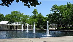
Kettering has 20 parks totaling 284 acres (1.15 km2) and is home to the Fraze Pavilion, a major outdoor entertainment venue that also hosts the summer concerts of the Dayton Philharmonic.

The James S. Trent Arena, which opened in 2005, has a seating capacity of 4,400 overall as well as 3,650 for championship sporting events, and it is located on the campus of Fairmont High School.

Skate Plaza, a 40,000-square-foot (3,700 m2) skateboard park that opened in 2005, was a collaboration between the City of Kettering and Rob Dyrdek, a professional skateboarder who grew up in Kettering.

Rosewood Arts Center, formerly an elementary school, now hosts 100,000 visitors a year with art classes, exhibitions, an art gallery and the Art on the Commons festival.

The Town and Country Shopping Center is a small, partly enclosed and part open-air, mall located in the heart of Kettering near the intersection of Far Hills Ave. and Stroop Rd.

Pondview Park is a self-guided environmental park for people to go experience nature. The park has trails, 6 ponds, a butterfly garden, and many scenic opportunities, for all kinds of people to come and learn about nature. [13]

Government

Kettering Government Center Kettering Government Center.jpg
Kettering Government Center

The city utilizes a council-manager form of government. Seven council representatives are elected for four-year terms on a non-partisan basis. They include the mayor, two at large members, and one member from each of the four wards. The current Mayor is Peggy Lehner.[ citation needed ]

Education

The Kettering City School District includes Kettering Fairmont High School, two middle schools (Van Buren and Kettering), and eight elementary schools (Beavertown, Greenmont, Indian Riffle, J.E. Prass, J.F. Kennedy, Oakview, Orchard Park, and Southdale). On the 2009–2010 Ohio report card, Kettering schools met all 26 state standards in testing, attendance and graduation rates earning the state's highest category, Excellent with Distinction. [14]

Kettering is also home to several private schools—Alexandria Montessori School, Archbishop Alter High School, Ascension School, Emmanuel Christian Academy, St. Albert The Great School, and St. Charles Borromeo School.

Kettering College offers two-year and four-year degrees in several disciplines including Nursing, Sonography, Radiology Technology, Respiratory Therapy, and Human Biology; with a Master of Physician Assistant Studies (MPAS) and an Occupational Therapy Doctorate (OTD). The Modern College of Design offers two-year degrees in graphic design.

The international headquarters of the Driving Schools Association of the Americas (DSAA) is located in Kettering. The DSAA is one of the largest organizations in the world for the education of vehicle drivers and plays a significant educational role in improving road safety.

Kettering has two public libraries, both branches of the Dayton Metro Library. [15]

Transportation

The Greater Dayton Regional Transit Authority provides bus service in the city.

City services

The Kettering Fire Department is responsible for fire protection in the city. The department has a total of six operational stations and is staffed by 54 career and 50 volunteer firefighters. The fire department is currently undergoing a transformation to reduce the number of stations to five. One station is currently being built on Far Hills Avenue, one will be located on the corner of East David Road and Hempstead Station Drive. The three others are in the planning stage. [16]

Police protection is provided by the Kettering Police Department which comprises 83 sworn officers. The police department is the only agency of its size with dual accreditation from both the Commission on Accreditation for Law Enforcement Agencies and the Commission on Accreditation for Corrections. [17]

Notable people

Sister cities

Kettering has two sister cities , as designated by Sister Cities International :

Related Research Articles

<span class="mw-page-title-main">Montgomery County, Ohio</span> County in Ohio, United States

Montgomery County is located in the southwestern portion of the U.S. state of Ohio. As of the 2020 census, the population was 537,309, making it the fifth-most populous county in Ohio. The county seat is Dayton. The county was named in honor of Richard Montgomery, an American Revolutionary War general killed in 1775 while attempting to capture Quebec City, Canada. Montgomery County is part of the Dayton, Ohio Metropolitan Statistical Area.

<span class="mw-page-title-main">Trenton, Ohio</span> City in Ohio, United States

Trenton is a city in northeastern Butler County, Ohio, United States, west of Middletown. The population was 13,021 at the 2020 census. It is part of the Cincinnati metropolitan area.

<span class="mw-page-title-main">Crystal Lakes, Ohio</span> Census-designated place in Ohio, United States

Crystal Lakes is a census-designated place (CDP) in Clark County, Ohio, United States. The population was 1,394 at the 2020 census. It is part of the Springfield, Ohio Metropolitan Statistical Area.

<span class="mw-page-title-main">Sabina, Ohio</span> Village in Ohio, United States

Sabina is a village in Clinton County, Ohio, United States. As of the 2020 census, the village had a total population of 2,499.

<span class="mw-page-title-main">Harrison, Ohio</span> City in Ohio, United States

Harrison is a city in western Hamilton County, Ohio, United States. The population was 12,563 at the 2020 census. It is part of the Cincinnati metropolitan area.

<span class="mw-page-title-main">Brookville, Ohio</span> City in Ohio, United States

Brookville is a small city in northwestern Montgomery County, Ohio, United States. It is a suburb of Dayton. The population was 5,989 at the 2020 census.

<span class="mw-page-title-main">Centerville, Ohio</span> City in Ohio, United States

Centerville is a city in Montgomery County, Ohio, United States. A core suburb of Metro Dayton, its population was 24,240 as of the 2020 census.

<span class="mw-page-title-main">Clayton, Ohio</span> City in Ohio, United States

Clayton is a city in Montgomery County, Ohio, United States. The population was 13,310 at the 2020 census. A suburb of Dayton, it is part of the Dayton metropolitan area.

<span class="mw-page-title-main">Farmersville, Ohio</span> Village in Ohio, United States

Farmersville is a village in Jackson Township, Montgomery County, Ohio, United States. The population was 975 at the 2020 census. It is part of the Dayton Metropolitan Statistical Area.

<span class="mw-page-title-main">Moraine, Ohio</span> City in Ohio, United States

Moraine is a city in Montgomery County, Ohio, United States. Situated on the banks of the Great Miami River, Moraine is an inner suburb of Dayton, Ohio and a part of the Dayton metropolitan area. The population was 6,393 at the 2020 census.

<span class="mw-page-title-main">New Lebanon, Ohio</span> Village in Ohio, United States

New Lebanon is a village in Montgomery County, Ohio, United States. The population was 3,796 at the 2020 census. It is part of the Dayton Metropolitan Statistical Area.

<span class="mw-page-title-main">Oakwood, Montgomery County, Ohio</span> City in Ohio, United States

Oakwood is a city in Montgomery County, Ohio, United States. The population was 9,572 at the 2020 census. A suburb of Dayton, Oakwood is part of the Dayton metropolitan area. It was incorporated in 1908. John Henry Patterson, industrialist and founder of the National Cash Register Corporation, is considered the "Father of Oakwood."

<span class="mw-page-title-main">Riverside, Ohio</span> City in Ohio, United States

Riverside is a city in Montgomery County, Ohio, United States. The population was 24,474 at the 2020 census. A suburb of Dayton, it is part of the Dayton metropolitan area.

<span class="mw-page-title-main">Trotwood, Ohio</span> City in Ohio, United States

Trotwood is a city in Montgomery County, Ohio, United States. The population was 23,070 at the 2020 census. A suburb of Dayton, it is part of the Dayton metropolitan area. The city is served by the Trotwood-Madison City School District.

<span class="mw-page-title-main">West Carrollton, Ohio</span> City in Ohio, United States

West Carrollton is a city in Montgomery County, Ohio, United States. A suburb of Dayton, its population was 13,129 at the 2020 census. It is part of the Dayton Metropolitan Statistical Area. The Great Miami River runs through the town and forms most of its northern border.

<span class="mw-page-title-main">New Franklin, Ohio</span> City in Ohio, United States

New Franklin is a city in southwestern Summit County, Ohio, United States, in the northeastern part of the state. The population was 13,877 according to the 2020 census. It is part of the Akron metropolitan area.

<span class="mw-page-title-main">Franklin Township, Butler County, Pennsylvania</span> Township in Pennsylvania, United States

Franklin Township is a township in Butler County, Pennsylvania, United States. The population was 2,596 at the 2020 census.

<span class="mw-page-title-main">Monroe, Ohio</span> City in Ohio, United States

Monroe is a city in east central Butler and west central Warren counties in the southwestern part of the U.S. state of Ohio. The population was 15,412 at the 2020 census. Monroe is a part of the Cincinnati metropolitan area.

<span class="mw-page-title-main">Springboro, Ohio</span> City in Ohio, United States

Springboro is a city in the U.S. state of Ohio. A suburb of Cincinnati and Dayton, it is located mostly in Warren County in Clearcreek and Franklin Townships; with a small portion in Miami Township in Montgomery County. The city is part of the Miami Valley. As of the 2020 census, the city had a population of 19,062.

<span class="mw-page-title-main">Delafield, Wisconsin</span> Place in Wisconsin, United States

Delafield is a city in Waukesha County, Wisconsin, along the Bark River. The population was 7,085 at the 2010 census.

References

  1. "ArcGIS REST Services Directory". United States Census Bureau. Retrieved September 20, 2022.
  2. 1 2 U.S. Geological Survey Geographic Names Information System: Kettering, Ohio
  3. 1 2 3 "U.S. Census website". United States Census Bureau . Retrieved January 31, 2008.
  4. "Search Results".
  5. "History of the City". City of Moraine. October 24, 2017. Retrieved July 18, 2021.
  6. "Kettering History". Archived from the original on February 20, 2006. Retrieved September 11, 2012.
  7. "Charles F. Kettering history" . Retrieved September 11, 2012.
  8. "US Gazetteer files 2010". United States Census Bureau. Archived from the original on January 25, 2012. Retrieved January 6, 2013.
  9. "Number of Inhabitants: Ohio" (PDF). 18th Census of the United States. U.S. Census Bureau. 1960. Retrieved April 24, 2020.
  10. "Ohio: Population and Housing Unit Counts" (PDF). U.S. Census Bureau. Retrieved November 22, 2013.
  11. "U.S. Census Bureau QuickFacts: Kettering". U.S. Census Bureau. Retrieved August 30, 2021.
  12. "U.S. Census website". United States Census Bureau . Retrieved January 6, 2013.
  13. "Pondview Park reopens to public". dayton-daily-news. Retrieved October 13, 2022.
  14. "Kettering City Schools Rankings" . Retrieved August 24, 2010.
  15. "Locations". Dayton Metro Library. Retrieved March 10, 2018.
  16. "About Kettering's Fire Department" . Retrieved January 8, 2015.
  17. Kettering Police Department Archived 2007-02-10 at the Wayback Machine