Steyr

Last updated • 8 min readFrom Wikipedia, The Free Encyclopedia
Steyr
Steia
Blick ueber die Steyrer Altstadt.jpg
View over the Old Town with city hall and parish church
Flag of Steyr.gif
AUT Steyr COA.svg
Austria Upper Austria location map.svg
Red pog.svg
Steyr
Location within Austria
Austria adm location map.svg
Red pog.svg
Steyr
Steyr (Austria)
Coordinates: 48°02′N14°25′E / 48.033°N 14.417°E / 48.033; 14.417
Country Flag of Austria.svg  Austria
State Flag of Oberosterreich.svg  Upper Austria
District Statutory city
Government
   Mayor Markus Vogl (SPÖ)
Area
[1]
  Total
26.56 km2 (10.25 sq mi)
Elevation
310 m (1,020 ft)
Population
 (2018-01-01) [2]
  Total
38,331
  Density1,400/km2 (3,700/sq mi)
Time zone UTC+1 (CET)
  Summer (DST) UTC+2 (CEST)
Postal code
4400
Area code 07252
Vehicle registration SR
Website www.steyr.at

Steyr (German: [ˈʃtaɪɐ] ; Central Bavarian : Steia) is a statutory city, located in the Austrian federal state of Upper Austria. It is the administrative capital, though not part of Steyr-Land District. Steyr is Austria's 12th most populated town and the 3rd largest city in Upper Austria.

Contents

The city has a long history as a manufacturing center and has given its name to several manufacturers headquartered there, such as the former Steyr-Daimler-Puch conglomerate and its successor Steyr Motors.

Geography

Saint Michael's Church, at the confluence of the Enns and Steyr rivers Steyr Town 01.jpg
Saint Michael's Church, at the confluence of the Enns and Steyr rivers

The city is situated in the Traunviertel region, with the two rivers Steyr and Enns flowing through it and meeting near the town centre beneath Lamberg Castle and St Michael's Church. This prominent location has made it prone to severe flooding through the centuries until the present, one of the worst cases being recently in August 2002. To the south of the town rises a series of hills that climb in altitude and stretch out to the Upper Austrian Prealps. To the north, the hills roll downward towards the confluence of the Enns with the Danube River, where the town of Enns is situated. In the east, the municipal area borders with Lower Austria.

Steyr is an ancient town with modern amenities, marketing its rich cultural and architectural heritage in tourism like Vienna and many other well preserved Austrian historic towns. It marked its 1,000th anniversary in 1980, after undergoing extensive restoration of its historic architecture which has made it one of the best preserved old towns in the country. The famous historic town centre built around the Stadtplatz (town square) was largely restored following World War II. Its best-known piece of architecture is called the Bummerlhaus which is considered one of the finest examples of Gothic architecture for its size in Central Europe.

The city comprises the cadastral communities of Christkindl, Föhrenschacherl, Gleink, Hinterberg, Jägerberg, Sarning, Stein, and Steyr.

History

Quayside at Enns river Steyr Town 03.jpg
Quayside at Enns river
The town's landmark: Bummerlhaus Bummerlhaus Stadtplatz 32 Steyr DSC 2800w.jpg
The town's landmark: Bummerlhaus

Celts settled the area from about 600 BC, the name of the Stiria River is of Celtic origin. Their kingdom of Noricum became part of the Roman Empire in 15 BC. A settlement named Gesodunum noted by the ancient geographer Claudius Ptolemy (c. 90 – c. 168) was possibly located in the Steyr region. Here the Roman "Iron Road" led from the Erzberg mine along the Enns River to the castra of Lauriacum (at present-day Enns) on the Danube.

In the 6th century, Slavic settlers moved into the area, but when they were defeated by Duke Tassilo III of Bavaria, who granted the land to nearby Kremsmünster Abbey in 777, the area was resettled with Bavarians. During the Hungarian invasions of Europe, a fortress was erected above the Steyr River by the local Traungau counts, first mentioned as Styraburg in a 980 deed. From 1055 Steyr Castle in the Bavarian Traungau as well as the adjacent "March of Styria" were ruled by the mighty Otakar dynasty. The Otokars controlled the iron mining at Erzberg and made their residence at Steyr a centre of medieval courtly culture and Middle High German poetry.

In 1180, Emperor Frederick Barbarossa elevated Margrave Ottokar IV to a Duke of Styria; however, the line became extinct upon his death in 1192 and, according to the 1186 Georgenberg Pact, his Styrian lands fell to the Babenberg dukes of Austria.

Steyr, already named a town (urbs) by then, lost its importance as a ducal residence but retained its status as a centre of ironworking. The Babenberg rulers promoted its economic development as a site of blacksmithing, mainly knife making and armament industry. After the extinction of the Babenbergs in 1246, Steyr together with the Duchy of Austria was occupied by the Přemyslid king Ottokar II of Bohemia and finally taken over by the Habsburg king Rudolf I of Germany upon his victory at the 1278 Battle on the Marchfeld. The town privileges and market rights were confirmed by Rudolf's son King Albert I in 1287 and the citizens further on benefitted of Steyr's preferred position within the iron trade all over the Holy Roman Empire and especially with the Republic of Venice.

In the 13th and 14th century, Steyr was a centre of the Christian Waldensian movement and a location of the inquisitorial persecutions led by the Catholic cleric Petrus Zwicker (d. 1403). Likewise, the Protestant Reformation quickly spread among the citizens about 1525, fiercely opposed by the Habsburg rulers in the course of the Counter-Reformation.

The economic situation changed for the worse, as the iron trade decayed during the Thirty Years' War, when Upper Austria was pawned to Duke Maximilian I of Bavaria, and the Peasants' War in Upper Austria of 1626. In 1727 the medieval Styraburg was devastated by a blaze and replaced by the Baroque Lamberg Castle. The resurgence of Steyr began under the conditions of late 18th century Josephinism and continued in the course of the succeeding industrialisation. During the Napoleonic Wars Steyr was occupied by French troops several times. On 25 December 1800, the Armistice of Steyr was signed there.

In 1830 the blacksmith Leopold Werndl founded an armory at Steyr, which his sons Josef and Franz Werndl re-established as a stock company in 1864, named the Österreichische Waffenfabriksgesellschaft (ÖWG) from 1869. Including the Steyr automobile branch from 1915 it was renamed Steyr-Werke AG in 1926 and formed a large industrial conglomerate by the merger with Austro-Daimler and Puch in 1934. However, the Steyr industry was hit hard by the 1929 Great Depression.

In 1934, the town became one of several battlegrounds between Social Democratic Schutzbund paramilitary forces and Christian Social Heimwehr militias in the Austrian Civil War, which brought about the fascist corporate Federal State of Austria that ruled the country until the 1938 Anschluss to Nazi Germany.

The Nazi authorities incorporated the armament industry into the vast Reichswerke Hermann Göring conglomerate, including the construction of the Steyr-Münichholz subcamp of forced labourers, part of the Mauthausen network. A major producer of arms and military vehicles during World War II, Steyr became a target of Allied bombing raids to knock out its factories. In two major attacks by the US Fifteenth Air Force during the "Big Week" on 23 and 24 February 1944, much of the town was badly damaged, but the factories continued to function until near the end of the war.

The city was a meeting point on 9 May 1945, when units of the 5th Guards Airborne of the Red Army and black troops of the US 761st Tank Battalion along with the 71st Infantry Division contacted each other on the bridge over the Enns River. Steyr was occupied by the U.S. Army—the Soviet Army moved east behind the demarcation line of the province of Lower Austria. The troops remained until 1955 when Austria officially declared neutrality by the Austrian State Treaty.

Population

Largest groups of foreign residents
NationalityPopulation (2014)
Flag of Bosnia and Herzegovina.svg  Bosnia and Herzegovina 1,524
Flag of Turkey.svg  Turkey 879
Flag of Germany.svg  Germany 580
Flag of Croatia.svg  Croatia 385
Flag of Slovakia.svg  Slovakia 334
Historical population
YearPop.±%
186916,593    
188021,054+26.9%
189026,139+24.2%
190022,272−14.8%
191022,205−0.3%
192327,200+22.5%
193425,351−6.8%
193931,017+22.4%
195136,818+18.7%
196138,306+4.0%
197140,822+6.6%
198138,942−4.6%
199139,337+1.0%
200139,340+0.0%
201138,313−2.6%
201438,273−0.1%

Local council

The local council (Gemeinderat) has 36 members. Elections in 2015 showed the following results:

Economy

The most heavily represented sector is manufacturing automotive parts. The most significant companies in Steyr are:

In other sectors are also important Austrian companies in Steyr:

[4]

Infrastructure

Health systems

The Pyhrn-Eisenwurzen Klinikum Steyr is the general hospital of the city and the largest health care provider in the region with a capacity of 621 beds. It is also a teaching hospital affiliated with the medical universities of Vienna, Graz and Innsbruck. [5]

The Steyr School of General Health and Nursing offers a degree in nursing science and training to become a certified nurse. The oldest part is the 1916 castle-like old building. The hospital has been continually expanded since 1935.[ citation needed ]

Energy

Outside view of the biomass heating plant Steyr Biomasseheizkraftwerk Steyr, Aussenansicht mit Radfahrerin.jpg
Outside view of the biomass heating plant Steyr

Steyr has a district heating system which supplies the bulk of the buildings and industry with renewable energy. The thermal energy comes from the Steyr biomass heating plant. [6]

Sport

The local professional football team is SK Vorwärts Steyr who play at the Vorwärts Stadium.

Notable people

Steyr has had a number of well-known residents or visitors, including Franz Schubert (1797–1828), who wrote his Trout Quintet there while on holiday in 1819, and composer Anton Bruckner (1824–1896), organist at the local parish church. Young Adolf Hitler spent a brief period there while he attended the Steyr secondary school in 1904, living in a room on Grünmarkt. The school is located in the same building as the famous Saint Michael's Church. Further notable natives of Steyr are:

Ferdinand Redtenbacher Redtenbacher Ferdinand Portrat.JPG
Ferdinand Redtenbacher
Hannes Trinkl, 2008 Hannes Trinkl Nacht des Sports 2008.jpg
Hannes Trinkl, 2008

Sport

International relations

Steyr is twinned with:

Related Research Articles

<span class="mw-page-title-main">Upper Austria</span> State in Austria

Upper Austria is one of the nine states or Länder of Austria. Its capital is Linz. Upper Austria borders Germany and the Czech Republic, as well as the other Austrian states of Lower Austria, Styria, and Salzburg. With an area of 11,982 km2 (4,626 sq mi) and 1.49 million inhabitants, Upper Austria is the fourth-largest Austrian state by land area and the third-largest by population.

<span class="mw-page-title-main">Judenburg</span> Place in Styria, Austria

Judenburg is a historic town in Styria, Austria.

<span class="mw-page-title-main">Styria</span> Austrian federal state

Styria is an Austrian state in the southeast of the country, famed for its idyllic landscapes, as well as rich folk- and high culture. With an area of approximately 16,399 km2 (6,332 sq mi), Styria is Austria's second largest state, after Lower Austria. It is bordered to the south by Slovenia, and clockwise, from the southwest, by the other Austrian states of Carinthia, Salzburg, Upper Austria, Lower Austria, and Burgenland. The state's capital is Graz, the second largest city in Austria after only Vienna.

<span class="mw-page-title-main">Wels</span> City in Upper Austria, Austria

Wels is a city in Upper Austria, on the Traun River near Linz. It is the county seat of Wels-Land, and with a population of approximately 60,000, the eighth largest city in Austria.

<span class="mw-page-title-main">Salzkammergut</span> Resort area in Austria

The Salzkammergut is a resort area in Austria, stretching from the city of Salzburg eastwards along the Alpine Foreland and the Northern Limestone Alps to the peaks of the Dachstein Mountains. The main river of the region is the Traun, a right tributary of the Danube.

<span class="mw-page-title-main">Enns (river)</span> River in Austria

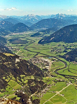
The Enns is a southern tributary of the river Danube in Austria, joining northward at the city of Enns. It forms much of the border between the states of Lower Austria and Upper Austria. The Enns spans 253 kilometres (157 mi), in a flat-J-shape. It flows from its source near the village Flachau, generally eastward through Radstadt, Schladming, and Liezen, then turns north near Hieflau, to flow past Weyer and Ternberg through Steyr, and further north to the Danube at Enns.

<span class="mw-page-title-main">Georgenberg Pact</span> 1186 treaty unifying the duchies of Austria and Styria

The Georgenberg Pact was a treaty signed between Duke Leopold V of Austria and Duke Ottokar IV of Styria on 17 August 1186 at Enns Castle on the Georgenberg mountain.

<span class="mw-page-title-main">Ottokar IV, Duke of Styria</span> Margrave (later Duke) of Styria from 1164 to 1192

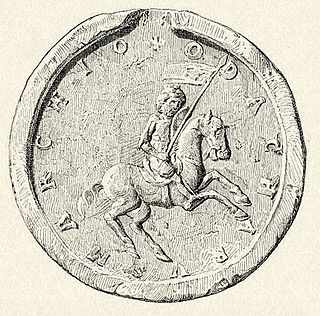
Ottokar IV, a member of the Otakar dynasty, was Margrave of Styria from 1164 and Duke from 1180, when Styria, previously a margraviate subordinated to the stem duchy of Bavaria, was raised to the status of an independent duchy.

<span class="mw-page-title-main">Duchy of Bavaria</span> Former duchy in Germany

The Duchy of Bavaria was a frontier region in the southeastern part of the Merovingian kingdom from the sixth through the eighth century. It was settled by Bavarian tribes and ruled by dukes (duces) under Frankish overlordship. A new duchy was created from this area during the decline of the Carolingian Empire in the late ninth century. It became one of the stem duchies of the East Frankish realm, which evolved as the Kingdom of Germany and the Holy Roman Empire.

<span class="mw-page-title-main">Innviertel</span> Traditional region of Upper Austria

The Innviertel is a traditional Austrian region southeast of the Inn river. It forms the western part of the state of Upper Austria and borders the German state of Bavaria. The Innviertel is one of the four traditional "quarters" of Upper Austria, the others being Hausruckviertel, Mühlviertel, and Traunviertel.

Steyr Arms is a firearms manufacturer based in Sankt Peter in der Au, Austria. Originally part of Steyr-Daimler-Puch, it became independent when the conglomerate was broken up in 1989. Prior to 1 January 2019, the company was named Steyr Mannlicher AG. In April 2024, the company was acquired by Czech holding RSBC, which owns also Slovenian gun maker Arex Arms.

<span class="mw-page-title-main">Garsten Abbey</span> Building in Upper Austria, Austria

Garsten Abbey is a former Benedictine monastery located in Garsten near Steyr in Upper Austria. Since 1851, the former monastery buildings have accommodated a prison.

<span class="mw-page-title-main">Ennstal Alps</span>

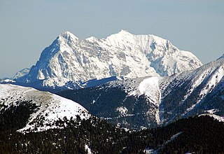
The Ennstal Alps, the Alps of the Enns valley, are a mountain range of the Northern Limestone Alps System. They are located primarily in the Austrian state of Styria, and also into the state of Upper Austria.

<span class="mw-page-title-main">Duchy of Austria</span> State of the Holy Roman Empire (1156–1453)

The Duchy of Austria was a medieval principality of the Holy Roman Empire, established in 1156 by the Privilegium Minus, when the Margraviate of Austria (Ostarrîchi) was detached from Bavaria and elevated to a duchy in its own right. After the ruling dukes of the House of Babenberg became extinct in male line, there was as much as three decades of rivalry on inheritance and rulership, until the German king Rudolf I took over the dominion as the first monarch of the Habsburg dynasty in 1276. Thereafter, Austria became the patrimony and ancestral homeland of the dynasty and the nucleus of the Habsburg monarchy. In 1453, the archducal title of the Austrian rulers, invented by Duke Rudolf IV in the forged Privilegium Maius of 1359, was officially acknowledged by the Habsburg emperor Frederick III.

<span class="mw-page-title-main">Steyr (river)</span> River in Upper Austria, Austria

The Steyr is a river in Upper Austria. Its length is approx. 68 km (42 mi). Its drainage basin is 917 km2 (354 sq mi).

<span class="mw-page-title-main">March of Pannonia</span> Frontier territory of the Carolingian Empire

The March of Pannonia or Eastern March was a frontier march of the Carolingian Empire, named after the former Roman province of Pannonia and carved out of the preceding and larger Avar March.

<span class="mw-page-title-main">Margraviate of Austria</span> Southeastern frontier march of the Holy Roman Empire, c. 970–1156

The Margraviate of Austria was a medieval frontier march, centered along the river Danube, between the river Enns and the Vienna Woods, within the territory of the modern Austrian provinces of Upper Austria and Lower Austria. It existed from c. 970 to 1156.

<span class="mw-page-title-main">March of Styria</span> Geography

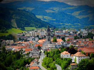
The March of Styria, originally known as Carantanian march, was a southeastern frontier march of the Holy Roman Empire. It was broken off the larger March of Carinthia, itself a march of the Duchy of Bavaria, around 970 as a buffer zone against the Hungarian invasions. Under the overlordship of the Carinthian dukes from 976 onwards, the territory evolved to be called Styria, so named for the town of Steyr, then the residence of the Otakar margraves. It became an Imperial State in its own right, when the Otakars were elevated to Dukes of Styria in 1180.

<span class="mw-page-title-main">Ternberg</span> Place in Upper Austria, Austria

Ternberg is a municipality in the district of Steyr-Land in the Austrian state of Upper Austria.

<span class="mw-page-title-main">Pyhrn railway line</span> Railway line in Austria

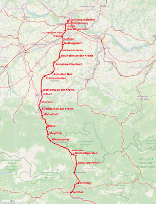
The Pyhrn railway line is a railway line in Upper Austria. It runs 104.2 kilometres (64.7 mi) from Linz Hauptbahnhof, where it connects with the Western railway line, to Selzthal, where it connects with the Enns Valley Railway and Rudolf Railway. The line takes its name from the Pyhrn Pass through which it runs.

References

  1. "Dauersiedlungsraum der Gemeinden Politischen Bezirke und Bundesländer - Gebietsstand 1.1.2018". Statistics Austria. Retrieved 10 March 2019.
  2. "Einwohnerzahl 1.1.2018 nach Gemeinden mit Status, Gebietsstand 1.1.2018". Statistics Austria. Retrieved 9 March 2019.
  3. Mitglieder des Gemeinderats
  4. "AVL List GMBH | AVL".
  5. "Kurzinfo". Pyhrn-Eisenwurzen Klinikum. Retrieved 7 February 2022.
  6. "Bioenergie Steyr". www.fernwaermesteyr.at. Archived from the original on 2014-05-17.
  7. "Wickhoff, Franz". www.arthistorians.info. 2018-02-21. Retrieved 2018-03-30.