Springboro, Ohio

Last updated

Springboro, Ohio
City of Springboro
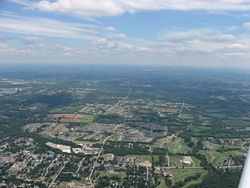
Springboro and Clearcreek Township.jpg
Lower Springboro from the air
Motto: 
"Live. Work. Play. Learn. Grow."
OHMap-doton-Springboro.png
Location of Springboro, Ohio
Map of Warren County Ohio Highlighting Springboro City.png
Location of Springboro in Warren County
Coordinates: 39°33′35″N84°15′18″W / 39.55972°N 84.25500°W / 39.55972; -84.25500
Country United States
State Ohio
Counties Warren, Montgomery
Area
[1]
  Total
9.21 sq mi (23.85 km2)
  Land9.21 sq mi (23.85 km2)
  Water0.00 sq mi (0.00 km2)
Elevation
[2]
804 ft (245 m)
Population
 (2020)
  Total
19,062
  Density2,069.93/sq mi (799.21/km2)
Time zone UTC-5 (Eastern (EST))
  Summer (DST) UTC-4 (EDT)
ZIP code
45066, 45342
Area code(s) 937, 326
FIPS code 39-74076 [3]
GNIS feature ID2395938 [2]
Website http://www.cityofspringboro.com/

Springboro is a city in the U.S. state of Ohio. Regarded as a suburb of Cincinnati and Dayton, [4] it is located mostly in Warren County in Clearcreek and Franklin Townships; with a small portion in Miami Township in Montgomery County. The city is part of the Miami Valley. As of the 2020 census, the city had a population of 19,062.

Contents

Springboro is located at the geographic center of the Cincinnati-Dayton Metroplex, the 14th largest urban area in the United States. [5] [6] Most of the city is located in Warren County, and is part of Metro Cincinnati. The far northern portion is in Montgomery County, the central county of Metro Dayton. Most of Springboro is served by the Springboro Community School District and its high school, Springboro High School.

Geography

According to the United States Census Bureau, the city has a total area of 9.36 square miles (24.24 km2), all land. [7]

Transportation

Springboro is accessible by three of the major expressways in the Cin-Day Metro Region:

The main crossroads of the city center are OH-73.svg SR 73 (Central Avenue) and OH-741.svg SR 741 (Springboro Pike/Main Street). Central Avenue runs east–west, and Springboro Pike/Main Street is the north–south thru-way, connecting the city with the urban cores of Cincinnati and Dayton. Main Street is also used as an alternate route to Interstate-75.

Springboro is served by the Greater Dayton RTA by a single bus stop on the extreme northern border of the city at Austin Landing. [8]

Dayton-Wright Brothers Airport is located on Springboro Pike, near the city's northern border along the Montgomery-Warren County line. The airport serves strictly private jets and small planes. The airport also serves as a small museum with a scale-replica of the original Wright-B Flyer. For commercial service, James M. Cox-Dayton International Airport and Cincinnati-Northern Kentucky International Airport are each about an hour north or south of the city, respectively. [9] [10]

History

Settled as early as 1796, Springboro was founded in 1815 by Jonathan Wright, as "Springborough." Jonathan Wright's father Joel was a surveyor who plotted Columbus and Dayton, Ohio and Louisville, Kentucky. Springboro was predominantly Quaker during its early years.

By the 1830s, two mills and a woolen factory in Springboro had been built up on the abundant springs for which the town was named. [11]

As a stop on the Underground Railroad, Springboro played a significant role by providing hiding places for escaping slaves. [12] On October 17, 1999, Springboro was the first city to erect an Ohio Underground Railroad Historic Marker. The dedication was part of the 4th Annual Ohio Underground Railroad Summit.

Beginning in the late 1990s, Springboro's population began a boom that would redefine the city. Fueled by the growth of the Dayton Area, Springboro transformed from a sleepy town along I-75 into a real estate hotspot in the Miami Valley. Growth in Springboro led to a new highway exit being created at I-75 & Austin Boulevard and the construction of three new schools by the SCCSD in the 2000s. Today Springboro is one of the most important suburbs in the Cincinnati-Dayton metro area due to its stronghold on the growth between the two major cities. The mayor of Springboro is John H. Agenbroad, who was reelected in 2019. [13] The vast majority of new development occurred to the east of SR-741 (Main Street).

Demographics

Historical population
CensusPop.Note
1850 454
1860 51212.8%
1870 477−6.8%
1880 55315.9%
1890 413−25.3%
1900 4334.8%
1910 355−18.0%
1920 341−3.9%
1930 3667.3%
1940 46627.3%
1950 51610.7%
1960 91777.7%
1970 2,799205.2%
1980 4,96277.3%
1990 6,59032.8%
2000 12,38087.9%
2010 17,40940.6%
2020 19,0629.5%
2021 (est.)19,2631.1%
Sources: [3] [14] [15] [16] [17] [18] [19] [20]
Western Springboro (Central Ave.) Springboro OH USA.JPG
Western Springboro (Central Ave.)

As of the 2010 U.S. Census, the median household income for the city in 2010 was $104,803, and the median family income was $105,681. [21] In 2012, the median household income rose to $116,012 (~$152,230 in 2023), making Springboro the 32nd wealthiest City/Town in the country. At the end of 2013 the median net worth per household was estimated at $1,499,516 and the per capita income for the city was $78,786, the highest out of all incorporated cities in Ohio. This ranks Springboro's 45066 zip-code as the 61st wealthiest in the United States. [22] About 0.64% of families and 1.0% of the population were below the poverty line, including ≈0% of those under age 18 and 2.1% of those age 65 or over.

2010 census

As of the census [23] of 2010, there were 17,442 people, 5,996 households, and 4,871 families living in the city. The population density was 1,859.9 inhabitants per square mile (718.1/km2). There were 6,263 housing units at an average density of 669.1 per square mile (258.3/km2). The racial makeup of the city was 92.1% White, 2.3% African American, 0.1% Native American, 3.4% Asian, 0.4% from other races, and 1.7% from two or more races. Hispanic or Latino of any race were 1.8% of the population.

There were 5,996 households, of which 47.8% had children under the age of 18 living with them, 69.4% were married couples living together, 8.1% had a female householder with no husband present, 3.7% had a male householder with no wife present, and 18.8% were non-families. 15.8% of all households were made up of individuals, and 6% had someone living alone who was 65 years of age or older. The average household size was 2.89 and the average family size was 3.24.

The median age in the city was 36.4 years. 32.2% of residents were under the age of 18; 5% were between the ages of 18 and 24; 28.5% were from 25 to 44; 25% were from 45 to 64; and 9.3% were 65 years of age or older. The gender makeup of the city was 48.9% male and 51.1% female.

2000 census

As of the census [3] of 2000, there were 12,380 people, 4,261 households, and 3,600 families living in the city. The population density was 1,405.1 inhabitants per square mile (542.5/km2). There were 4,423 housing units at an average density of 502.0 per square mile (193.8/km2). The racial makeup of the city was 96.00% White, 0.99% African American, 0.16% Native American, 1.60% Asian, 0.03% Pacific Islander, 0.29% from other races, and 0.92% from two or more races. Hispanic or Latino of any race were 1.00% of the population.

There were 4,261 households, of which 48.2% had children under the age of 18 living with them, 74.8% were married couples living together, 7.3% had a female householder with no husband present, and 15.5% were non-families. 13.0% of all households were made up of individuals, and 3.9% had someone living alone who was 65 years of age or older. The average household size was 2.90 and the average family size was 3.18.

The city's population included 32.3% under the age of 18, 5.1% from 18 to 24, 34.0% from 25 to 44, 22.3% from 45 to 64, and 6.2% who were 65 years of age or older. The median age was 34 years. For every 100 females, there were 95.8 males. For every 100 females age 18 and over, there were 93.9 males.

Public safety

The Springboro Police Department consists of thirty-two officers and a civilian staff of five. [24] Chief Dan Bentley is the current police chief. [25] Approximately 11 square miles are patrolled with service provided to more than 17,000 residents. Many areas of expertise and specialization are utilized, including Special Weapons And Tactics (SWAT), bike patrol, firearms instruction, hostage negotiation, crime prevention, juvenile diversion, and D.A.R.E.

The Clearcreek Fire District provides fire protection for the City of Springboro and Clearcreek Township. Chief Steve Agenbroad oversees the department with a staff of approximately 55 firefighters. The district covers 47 square miles, from three stations staffed with 18 firefighters per day. The district responds to around 3,000 calls each year.

Education

The city lies entirely in the Springboro Community City School District. Unincorporated areas of Franklin and Miami Townships on the west and northwest side of Springboro are served by the Franklin City School District and the Miamisburg City School District, but have Springboro addresses and share the 45066 zip code. The Springboro Community City Schools ranked Excellent with Distinction in the 2011–2012 school year and received national recognition as a Blue-Ribbon School in 2012.

Springboro has the Springboro Public Library, a branch of the Franklin-Springboro Public Library. [26]

Arts and culture

Wright "B" Flyer Museum Wright B Flyer Museum.JPG
Wright "B" Flyer Museum

The city is home to the 1911 Wright B Flyer Museum, as well as the La Comedia Dinner Theatre.

Springboro also has golf courses and parks. Some of the green space belongs private neighborhoods, although the city operates a public golf course, Heatherwoode Golf Course, which opened in 1991. [27]

Notable people born in Springboro, OH

Related Research Articles

<span class="mw-page-title-main">Montgomery County, Ohio</span> County in Ohio, United States

Montgomery County is in the southwestern part of the U.S. state of Ohio. At the 2020 census, the population was 537,309, making it the fifth-most populous county in Ohio. The county seat is Dayton. The county was named in honor of Richard Montgomery, an American Revolutionary War general, who was killed in 1775 while attempting to capture Quebec City, Canada. Montgomery County is part of the Dayton, Ohio, Metropolitan Statistical Area.

<span class="mw-page-title-main">Warren County, Ohio</span> County in Ohio, United States

Warren County is a county located in the southwestern part of the U.S. state of Ohio. As of the 2020 census, the population was 242,337. Its county seat is Lebanon and largest city is Mason. The county is one of Ohio's most affluent, with the highest median income of the state's 88 counties. The county was established on May 1, 1803, from Hamilton County; it is named for Dr. Joseph Warren, a hero of the Revolution who sent Paul Revere and the overlooked William Dawes on their famous rides and who died at the Battle of Bunker Hill. Warren County is part of the Cincinnati, OH-KY-IN Metropolitan Statistical Area.

<span class="mw-page-title-main">Hardin County, Ohio</span> County in Ohio, United States

Hardin County is a county located in the west central portion of the U.S. state of Ohio. As of the 2020 census, the population was 30,696. Its county seat and largest city is Kenton. The county was created in 1820 and later organized in 1833. It is named for John Hardin, an officer in the American Revolution.

<span class="mw-page-title-main">Greene County, Ohio</span> County in Ohio, United States

Greene County is located in the southwestern portion of Ohio. As of the 2020 census, the population was 167,966. Its county seat is Xenia and its largest city is Beavercreek. The county was established on March 24, 1803 and named for General Nathanael Greene, an officer in the Revolutionary War. Greene County is part of the Dayton, OH Metropolitan Statistical Area.

<span class="mw-page-title-main">Fairfield County, Ohio</span> County in Ohio, US

Fairfield County is a county located in the U.S. state of Ohio. As of the 2020 census, the population was 158,921. Its county seat and largest city is Lancaster. Its name is a reference to the Fairfield area of the original Lancaster. Fairfield County is part of the Columbus, OH Metropolitan Statistical Area.

<span class="mw-page-title-main">Dayton, Kentucky</span> City in Kentucky, United States

The City of Dayton, Kentucky, is a home rule-class city along a bend of the Ohio River in Campbell County, Kentucky, United States. The population was 5,666 at the 2020 census. It is less than 3 miles (5 km) from downtown Cincinnati, Ohio.

<span class="mw-page-title-main">Beavercreek, Ohio</span> City in Ohio, United States

Beavercreek is a city in Greene County, Ohio, United States. The population was 46,549 at the 2020 census, making it the largest city in the county and the second-largest suburb of Dayton.

<span class="mw-page-title-main">Xenia, Ohio</span> City in Ohio, United States

Xenia is a city in and the county seat of Greene County, Ohio, United States. Located in southwestern Ohio, it is 15 miles (24 km) east of Dayton and is part of the Dayton metropolitan area as well as the Miami Valley region. As of the 2020 census, the city had a population of 25,441. The city's name comes from the Greek word Xenia (ξενία), which means "hospitality".

<span class="mw-page-title-main">Brookville, Ohio</span> City in Ohio, United States

Brookville is a small city in northwestern Montgomery County, Ohio, United States. It is a suburb of Dayton. The population was 5,989 at the 2020 census.

<span class="mw-page-title-main">Centerville, Ohio</span> City in Ohio, United States

Centerville is a city in Montgomery County, Ohio, United States. A core suburb of Metro Dayton, its population was 24,240 as of the 2020 census.

<span class="mw-page-title-main">Moraine, Ohio</span> City in Ohio, United States

Moraine is a city in Montgomery County, Ohio, United States. Situated on the banks of the Great Miami River, Moraine is an inner suburb of Dayton, Ohio and a part of the Dayton metropolitan area. The population was 6,393 at the 2020 census.

<span class="mw-page-title-main">Riverside, Ohio</span> City in Ohio, United States

Riverside is a city in Montgomery County, Ohio, United States. The population was 24,474 at the 2020 census. A suburb of Dayton, it is part of the Dayton metropolitan area.

<span class="mw-page-title-main">Vandalia, Ohio</span> City in Ohio, United States

Vandalia is a city in Montgomery County, Ohio, United States, and a suburb of Dayton. Its population was 15,209 during the 2020 census. In addition to being the city closest to Dayton International Airport, Vandalia lies at the crossroads of I-75 and I-70.

<span class="mw-page-title-main">Franklin, Ohio</span> City in Ohio, United States

Franklin is a city in Warren County, Ohio, United States, along the Great Miami River. The population was 11,690 at the 2020 census. The city lies about 15 miles (24 km) southwest of Dayton and 33.5 miles (53.9 km) northeast of Cincinnati. Ohio State Routes 73, 123 and 741 pass through Franklin, while Interstate 75 is routed to the east side of the city.

<span class="mw-page-title-main">Lebanon, Ohio</span> City in Ohio, United States

Lebanon is a city in and the county seat of Warren County, Ohio, United States. The population was 20,841 at the 2020 census. It is part of the Cincinnati metropolitan area.

<span class="mw-page-title-main">Monroe, Ohio</span> City in Ohio, United States

Monroe is a city in east central Butler and west central Warren counties in the southwestern part of the U.S. state of Ohio. The population was 15,412 at the 2020 census. Monroe is a part of the Cincinnati metropolitan area.

<span class="mw-page-title-main">Union, Ohio</span> City in Ohio, United States

Union is a city in Montgomery and Miami Counties in the U.S. state of Ohio. The population was 6,859 at the time of the 2020 census. It is part of the Dayton Metropolitan Statistical Area.

<span class="mw-page-title-main">Clearcreek Township, Warren County, Ohio</span> Township in Ohio, United States

Clearcreek Township is one of the eleven townships of Warren County, Ohio, United States, located in the north central portion of the county. It had a population of 36,238 in 2020. It was originally about forty-two square miles in area. The highest point in the county is in Clearcreek Township, near the community of Five Points. Statewide, the only other Clearcreek Townships are located in Fairfield County and in Ashland County.

<span class="mw-page-title-main">Dayton metropolitan area</span> Metropolitan Statistical Area in Ohio, United States

Metro Dayton or the Miami Valley, or more formally the Dayton–Kettering–Beavercreek, OH Metropolitan Statistical Area, as defined by the United States Census Bureau, is an area consisting of three counties in the Miami Valley region of Ohio and is anchored by the city of Dayton. As of 2020, it is the fourth-largest metropolitan area in Ohio and the 73rd-largest metropolitan area by population in the United States with a population of 814,049.

<span class="mw-page-title-main">Hagerstown, Indiana</span> Town in Indiana, United States

Hagerstown is a town in Jefferson Township, Wayne County, in the U.S. state of Indiana. As of the 2020 census, the population was 1,681.

References

  1. "ArcGIS REST Services Directory". United States Census Bureau. Retrieved September 20, 2022.
  2. 1 2 U.S. Geological Survey Geographic Names Information System: Springboro, Ohio
  3. 1 2 3 "U.S. Census website". United States Census Bureau . Retrieved January 31, 2008.
  4. bBudd, Lawrence. "Politics and business mix in new Cincinnati-Dayton collaboration". daytondailynews. Retrieved July 15, 2024.
  5. Chelsey Levingston, Staff Writer. "Politics and business mix in new Cincinnati-Dayton collaboration". daytondailynews. Retrieved May 24, 2020.
  6. "Ready for 'Daytonnati?' It could happen - 1998-11-09 - Cincinnati Business Courier". Archived from the original on November 29, 2003.
  7. "US Gazetteer files 2010". United States Census Bureau. Archived from the original on January 25, 2012. Retrieved January 6, 2013.
  8. "Google". www.google.com. Retrieved May 24, 2020.
  9. "Dayton International Airport - Easy to and Through". Dayton International Airport. Retrieved May 24, 2020.
  10. "Home". www.cvgairport.com. Retrieved May 24, 2020.
  11. Kilbourn, John (1833). The Ohio Gazetteer, or, a Topographical Dictionary. Scott and Wright. p. 425. Retrieved December 12, 2013.
  12. Lovelace, Janice (May 2004). Railroad Ties. Cincinnati magazine. p. 39.
  13. Lawrence Budd, Staff Writer. "Springboro attracting firms from neighboring cities". daytondailynews. Retrieved May 24, 2020.
  14. "Population of Civil Divisions Less than Counties" (PDF). Statistics of the Population of the United States at the Ninth Census. U.S. Census Bureau. 1870. Retrieved May 17, 2020.
  15. "Population of Civil Divisions Less than Counties" (PDF). Statistics of the Population of the United States at the Tenth Census. U.S. Census Bureau. 1880. Retrieved May 17, 2020.
  16. "Population: Ohio" (PDF). 1910 U.S. Census. U.S. Census Bureau. Retrieved May 17, 2020.
  17. "Population: Ohio" (PDF). 1930 US Census. U.S. Census Bureau. Retrieved May 17, 2020.
  18. "Number of Inhabitants: Ohio" (PDF). 18th Census of the United States. U.S. Census Bureau. 1960. Retrieved May 17, 2020.
  19. "Ohio: Population and Housing Unit Counts" (PDF). U.S. Census Bureau. Retrieved May 17, 2020.
  20. "Springboro city, Ohio". census.gov. Retrieved July 6, 2022.
  21. "Springboro Population & Demographics, Median Income - Point2 Homes". www.point2homes.com. Retrieved May 24, 2020.
  22. "Best Places to Live 2011 - Top 100: Town details: Springboro, OH - from MONEY Magazine". Best Places to Live 2011: Money's list of America's best small towns. Retrieved May 24, 2020.
  23. "U.S. Census website". United States Census Bureau . Retrieved January 6, 2013.
  24. "Patrol Division | Springboro, OH". www.cityofspringboro.com. Retrieved May 21, 2023.
  25. "Chief of Police | Springboro, OH". www.cityofspringboro.com. Retrieved May 21, 2023.
  26. "Homepage". Franklin-Springboro Public Library. Retrieved March 3, 2018.
  27. "Parks and Recreation - City of Springboro, Ohio, U.S.A." Archived from the original on February 19, 2015. Retrieved January 30, 2015.