
Warren County is a county located in the southwestern part of the U.S. state of Ohio. As of the 2020 census, the population was 242,337. Its county seat is Lebanon and largest city is Mason. The county is one of Ohio's most affluent, with the highest median income of the state's 88 counties. The county was established on May 1, 1803, from Hamilton County; it is named for Dr. Joseph Warren, a hero of the Revolution who sent Paul Revere and the overlooked William Dawes on their famous rides and who died at the Battle of Bunker Hill. Warren County is part of the Cincinnati, OH-KY-IN Metropolitan Statistical Area.

Butler County is a county located in the southwestern part of the U.S. state of Ohio. As of the 2020 census, the population was 390,357. Its county seat and largest city is Hamilton. It is named for General Richard Butler, who died in 1791 during St. Clair's Defeat. Located along the Great Miami River, it is also home to Miami University, a public university founded in 1809. Butler County is part of the Cincinnati, OH-KY-IN Metropolitan Statistical Area. The majority of the county is in District 52 of the State House.

Clearcreek Township is one of the eleven townships of Warren County, Ohio, United States, located in the north central portion of the county. It had a population of 36,238 in 2020. It was originally about forty-two square miles in area. The highest point in the county is in Clearcreek Township, near the community of Five Points. Statewide, the only other Clearcreek Townships are located in Fairfield County and in Ashland County.

Chautauqua , also Chautaugua or Chatauqua, is an unincorporated community in Montgomery and Warren counties in the U.S. state of Ohio. Chautauqua is located at 39°35′28″N84°17′47″W. It lies on the west bank of the Great Miami River at the county boundary. It was established in 1901 with 310 acres (1.3 km2). The members of the Miami Valley Chautauqua Association lived in common in the town, occupying about two hundred homes.

Hammel and Millgrove are extinct towns in western Warren County, Ohio, United States. They are located along the Little Miami River, about 2 miles (3 km) south of Fort Ancient and 1 mile north of Roachester at the Strout Road crossing of the river. Hammel lies on the eastern shore of the river, in southwestern Washington Township, and Millgrove lies on the western shore of the river, in northeastern Salem Township.

Greentree Corners is an unincorporated community in northern Turtlecreek Township, Warren County, Ohio, United States. It is located at the intersection of State Route 741 and Greentree Road about one and one-half miles north of Otterbein, two miles south of Red Lion, and three miles northwest of Lebanon.
The Middletown and Cincinnati Railroad is a historic railroad that operated in the southwest portion of the U.S. state of Ohio.

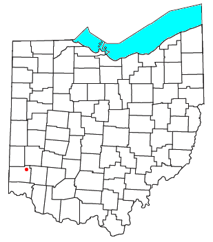
Dodds is an unincorporated community in eastern Clearcreek Township, Warren County, Ohio, United States, formerly on the Cincinnati, Lebanon and Northern Railway.

Hillcrest is an unincorporated place in central Warren County, Ohio, United States on U.S. Route 42 about halfway between Mason, 4 miles to the southwest, and Lebanon, 3 mi (5 km) to the northeast. The community straddles the township line between Turtlecreek and Union Townships. The former Cincinnati, Lebanon and Northern Railway runs just east of the community and once had a stop here called "Turtlecreek". It is in the Lebanon City School District and is served by the Lebanon telephone exchange and post office.

Level is an unincorporated community in southern Harlan Township, Warren County, Ohio, United States, which in the 19th century was a station on the Marietta and Cincinnati Railroad and had its own post office, since closed. According to the U.S. Geographic Names Information System (GNIS), an alternate name for this community is Windsor.

The Cincinnati, Lebanon and Northern Railway (CL&N) was a local passenger and freight-carrying railroad in the southwestern part of the U.S. state of Ohio, connecting Cincinnati to Dayton via Lebanon. It was built in the late 19th century to give the town of Lebanon and Warren County better transportation facilities. The railroad was locally known as the "Highland Route", since it followed the ridge between the Little and Great Miami rivers, and was the only line not affected by floods such as the Great Dayton Flood of 1913.

Bethany is an unincorporated community in southeastern Liberty Township, Butler County, Ohio, United States, located in the southwestern part of Ohio. It lies about three miles south of Monroe.

The Warren County Canal was a branch of the Miami and Erie Canal in southwestern Ohio about 20 miles (32 km) in length that connected the Warren County seat of Lebanon to the main canal at Middletown in the mid-19th century. Lebanon was at the crossroads of two major roads, the highway from Cincinnati to Columbus and the road from Chillicothe to the College Township (Oxford), but Lebanon businessmen and civic leaders wanted better transportation facilities and successfully lobbied for their own canal, part of the canal fever of the first third of the 19th century. The Warren County Canal was never successful, operating less than a decade before the state abandoned it.

Poast Town is an unincorporated community located in northeastern Madison Township, Butler County, Ohio, United States, on State Route 4, about one mile north of Middletown in Section 12 of T2R4 of the Congress Lands. It was laid out in 1818 by Peter Post as the town of West Liberty. A post office with the name Poast Town was established in 1848 but closed in 1934. Mail is provided through the Middletown post office, it is located in the Middletown telephone exchange. It is in the Madison Local School District.
West Middletown is an unincorporated community in eastern Madison Township, Butler County, Ohio, United States. It is located on the west shore of the Great Miami River about one mile from Middletown. It had about 200 people in 1905 and was formerly a station on the Cincinnati, Hamilton, and Dayton Railroad. Founded as Madison City, it received the name Heno when it was awarded a post office in 1882. Since there was already another Madison City in Ohio, the postmaster general demanded a name change. According to legend, as old-timers were discussing the new name around the cracker barrel in the general store, a can of Heno tea caught their attention. So the town was named for the tea. But in 1907, the postmaster general decreed the village was within the shadow of Middletown, and only a few postal workers had ever heard of Heno, making it difficult to sort and forward mail to the place. The government ordered the village to accept the name of West Middletown. In 1963 the postmaster general in another decree closed the West Middletown post office, transferring its business to Middletown.
Ohio's 1st congressional district is represented by Democrat Greg Landsman. The district includes the city of Cincinnati, all of Warren County and borders the state of Kentucky. This district was once represented by President William Henry Harrison. After redistricting in 2010, the district was widely seen as heavily gerrymandered by state Republicans to protect the incumbent, Steve Chabot. Chabot lost the seat in 2022 to Landsman, after redistricting unified the city of Cincinnati into the district. The city was previously split between the 1st and 2nd districts.

The Lebanon Mason & Monroe Railroad is a heritage railroad in Ohio. It offers passenger rides out of its depot in Lebanon, Ohio.

San Mar Gale is an unincorporated community and was a planned development by the Hines-Griffin Land Development Company in Turtlecreek of Warren County, Ohio, United States. This 2500+ home planned unit development was approved by the Warren County Commissioners in February 2006. Zoning approval included a central business district and multi-family housing near the center. A public referendum challenging the approval was placed on the ballot in November 2006, and the Commissioners approval was ratified by voters. Construction was to have begun in 2007, however the development was cancelled as of February 2011.
Turtle Creek is a 13.7-mile-long (22.0 km) tributary of the Little Miami River in Turtlecreek Township, Warren County, Ohio, which takes its name from this creek. Turtle Creek is named for Chief Little Turtle, of the Miami Indian Tribe Turtle Creek is a tributary within the Little Miami and Ohio River watersheds.

The Cincinnati metropolitan area is a metropolitan area with its core in Ohio and Kentucky. Its largest city is Cincinnati and includes surrounding counties in the U.S. states of Ohio, Kentucky, and Indiana.

