Dodds, Ohio

Last updated

Location of Dodds, Ohio OHMap-doton-Dodds.png
Location of Dodds, Ohio

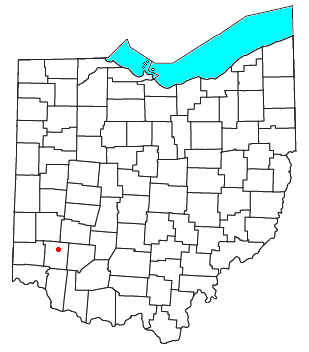
Dodds is an unincorporated community in eastern Clearcreek Township, Warren County, Ohio, United States. [1] It was formerly on the Cincinnati, Lebanon and Northern Railway.

History

A post office called Dodds was established in 1881, and remained in operation until 1901. [2] The Dodds family had settled the area in the early 19th century. [3]

Related Research Articles

<span class="mw-page-title-main">Ridgeville, Ohio</span> Unincorporated community in Ohio, US

Ridgeville is an unincorporated community in central Clearcreek Township, Warren County, Ohio, United States. It is located on State Route 48 in the north central part of the county, in sections 30 and 36, T4R4, Between the Miami Rivers Survey.

<span class="mw-page-title-main">Hagemans Crossing, Ohio</span> Unincorporated community in Ohio, U.S.

Hagemans Crossing is an unincorporated community in Union Township, Warren County, Ohio, United States. Located in the western part of the township, it is located on the old Cincinnati and Xenia Pike, now U.S. Route 42, about halfway between Lebanon and Mason. It was at the crossing of the Middletown and Cincinnati Railroad and the Cincinnati, Lebanon and Northern Railway and was about two miles northwest of the M&C's eastern terminus at Middletown Junction.

<span class="mw-page-title-main">Crosswick, Ohio</span> Unincorporated community in Ohio, U.S.

Crosswick is an unincorporated community in central Wayne Township, Warren County, Ohio, United States, located just outside Waynesville where Bellbrook Rd. meets Old Stage Rd.

<span class="mw-page-title-main">Cozaddale, Ohio</span> Unincorporated community in Ohio, U.S.

Cozaddale is an unincorporated community in southeastern Hamilton Township, Warren County, Ohio, United States. It is two miles west of Pleasant Plain, and three miles north of Goshen, Ohio.

<span class="mw-page-title-main">Oregonia, Ohio</span> Unincorporated community in Ohio, US

Oregonia is an unincorporated community in northwestern Washington Township, Warren County, Ohio, United States, on the east shore of the Little Miami River about five miles northeast of Lebanon and six miles south of Waynesville. The ZIP Code for Oregonia is 45054.

<span class="mw-page-title-main">Hammel and Millgrove, Ohio</span> Extinct towns in Ohio, U.S.

Hammel and Millgrove are extinct towns in western Warren County, Ohio, United States. They are located along the Little Miami River, about 2 miles (3 km) south of Fort Ancient and 1 mile north of Roachester at the Strout Road crossing of the river. Hammel lies on the eastern shore of the river, in southwestern Washington Township, and Millgrove lies on the western shore of the river, in northeastern Salem Township.

<span class="mw-page-title-main">Hopkinsville, Ohio</span> Unincorporated community in Ohio, U.S.

Hopkinsville is an unincorporated community in northern Hamilton Township, Warren County, Ohio, United States. It lies about one mile north of Maineville, two miles south of South Lebanon, and three miles northwest of Fosters at the crossroads of State Route 48 and the 3C Highway.

<span class="mw-page-title-main">Zoar, Warren County, Ohio</span> Unincorporated community in Ohio, U.S.

Zoar is an unincorporated community in northern Hamilton Township, Warren County, Ohio, United States. It is located on the 3C Highway about one mile east of Hopkinsville and three miles west of Morrow in Virginia Military District Military Survey 1546.

<span class="mw-page-title-main">Murdoch, Ohio</span> Unincorporated community in Ohio, U.S.

Murdoch is an unincorporated community in southern Hamilton Township, Warren County, Ohio, United States. It is located about two miles southeast of Maineville and two miles northwest of Cozaddale.

<span class="mw-page-title-main">Dallasburg, Ohio</span> Unincorporated community in Ohio, U.S.

Dallasburg is an unincorporated community in southern Hamilton Township, Warren County, Ohio, United States. It is located in Virginia Military Reserve Military Survey 3790, about one mile west of Cozaddale and two miles southeast of Murdoch.

<span class="mw-page-title-main">Hillcrest, Ohio</span> Unincorporated community in Ohio, U.S.

Hillcrest is an unincorporated place in central Warren County, Ohio, United States on U.S. Route 42 about halfway between Mason, 4 miles to the southwest, and Lebanon, 3 mi (5 km) to the northeast. The community straddles the township line between Turtlecreek and Union Townships. The former Cincinnati, Lebanon and Northern Railway runs just east of the community and once had a stop here called "Turtlecreek". It is in the Lebanon City School District and is served by the Lebanon telephone exchange and post office.

<span class="mw-page-title-main">Level, Ohio</span> Unincorporated community in Ohio, U.S.

Level is an unincorporated community in southern Harlan Township, Warren County, Ohio, United States, which in the 19th century was a station on the Marietta and Cincinnati Railroad and had its own post office, since closed. According to the U.S. Geographic Names Information System (GNIS), an alternate name for this community is Windsor.

<span class="mw-page-title-main">Red Lion, Ohio</span> Unincorporated community in Ohio, U.S.

Red Lion is an unincorporated community in southwestern Clearcreek Township, Warren County, Ohio, United States, at the intersection of State Routes 741, 122, and 123. Red Lion is approximately five miles south of Springboro and five miles northwest of Lebanon.

Pekin is an unincorporated community in Clearcreek Township, Warren County, Ohio, United States, at the intersection of State Route 48 and Pekin Road. Pekin is approximately 3 miles south of Springboro and 7 miles northwest of Lebanon.

Edwardsville is an unincorporated community in Warren County, in the U.S. state of Ohio. Edwardsville is the oldest community in Harlan Township.

Mount Holly is an unincorporated community in Warren County, in the U.S. state of Ohio.

Rossburg is an unincorporated community in Warren County, in the U.S. state of Ohio.

Socialville is an unincorporated community in Warren County, in the U.S. state of Ohio.

Blackhawk is an unincorporated community in Warren County, in the U.S. state of Ohio. A variant spelling is "Black Hawk".

Wellman is an unincorporated community in Massie Township, Warren County, in the U.S. state of Ohio.

References

  1. U.S. Geological Survey Geographic Names Information System: Dodds, Ohio
  2. "Warren County". Jim Forte Postal History. Archived from the original on January 22, 2016. Retrieved March 2, 2015.
  3. The History of Warren County, Ohio: Containing a History of the County ; Its Townships, Towns. W.H. Beers & Company. 1882. p. 633.

39°29′38″N84°09′12″W / 39.49389°N 84.15333°W / 39.49389; -84.15333