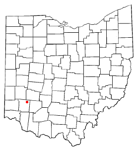
Waynesville, Ohio | |
---|---|
Village | |
Coordinates: 39°31′59″N84°05′25″W / 39.53306°N 84.09028°W [1] | |
Country | United States |
State | Ohio |
County | Warren |
Area | |
• Total | 2.37 sq mi (6.13 km2) |
• Land | 2.36 sq mi (6.12 km2) |
• Water | 0.01 sq mi (0.02 km2) |
Elevation | 856 ft (261 m) |
Population (2020) | |
• Total | 2,669 |
• Density | 1,129.50/sq mi (436.18/km2) |
Area codes | 513 |
FIPS code | 39-82418 |
GNIS feature ID | 2400117 [1] |
Website | www |
Waynesville is a village in Wayne Township, Warren County, Ohio, United States. The population was 2,669 at the 2020 census. It is named for General "Mad" Anthony Wayne. The village, located at the crossroads of U.S. Route 42 and State Route 73, is known for its antique stores and its annual sauerkraut festival. [3] Caesar Creek State Park is located 5 miles (8.0 km) east of the village.
Waynesville is served by the Mary L. Cook Public Library. In 2005, the library loaned more than 203,000 items to its 8,000 cardholders. Total holdings in 2005 were over 67,000 volumes with over 110 periodical subscriptions. [4]
According to the United States Census Bureau, the village has a total area of 2.39 square miles (6.19 km2), of which 2.38 square miles (6.16 km2) is land and 0.01 square miles (0.03 km2) is water. [5]
Little Miami River is the only river that flows through Waynesville.
Waynesville was laid out in 1796. [6] It was named in honor of General “Mad” Anthony Wayne. [7] Waynesville was originally built up chiefly by Quakers. [8] A post office has been in operation at Waynesville since 1804. [9]
Census | Pop. | Note | %± |
---|---|---|---|
1830 | 439 | — | |
1840 | 592 | 34.9% | |
1850 | 744 | 25.7% | |
1860 | 829 | 11.4% | |
1870 | 745 | −10.1% | |
1880 | 793 | 6.4% | |
1890 | 704 | −11.2% | |
1900 | 723 | 2.7% | |
1910 | 705 | −2.5% | |
1920 | 668 | −5.2% | |
1930 | 697 | 4.3% | |
1940 | 833 | 19.5% | |
1950 | 1,016 | 22.0% | |
1960 | 1,298 | 27.8% | |
1970 | 1,638 | 26.2% | |
1980 | 1,796 | 9.6% | |
1990 | 1,949 | 8.5% | |
2000 | 2,558 | 31.2% | |
2010 | 2,834 | 10.8% | |
2020 | 2,669 | −5.8% | |
U.S. Decennial Census [10] |
As of the census [11] of 2010, there were 2,834 people, 1,128 households, and 761 families living in the village. The population density was 1,190.8 inhabitants per square mile (459.8/km2). There were 1,196 housing units at an average density of 502.5 per square mile (194.0/km2). The racial makeup of the village was 96.8% White, 0.4% African American, 0.1% Native American, 0.4% Asian, 0.1% Pacific Islander, 0.1% from other races, and 2.1% from two or more races. Hispanic or Latino of any race were 1.2% of the population.
There were 1,128 households, of which 32.4% had children under the age of 18 living with them, 50.7% were married couples living together, 11.8% had a female householder with no husband present, 5.0% had a male householder with no wife present, and 32.5% were non-families. 29.0% of all households were made up of individuals, and 16.7% had someone living alone who was 65 years of age or older. The average household size was 2.42 and the average family size was 2.98.
The median age in the village was 41.6 years. 23.9% of residents were under the age of 18; 8.3% were between the ages of 18 and 24; 23.3% were from 25 to 44; 26.6% were from 45 to 64; and 17.9% were 65 years of age or older. The gender makeup of the village was 46.9% male and 53.1% female.
As of the census [12] of 2000, there were 2,558 people, 1,005 households, and 721 families living in the village. The population density was 1,124.8 inhabitants per square mile (434.3/km2). There were 1,037 housing units at an average density of 456.0 per square mile (176.1/km2). The racial makeup of the village was 98.32% White, 0.08% African American, 0.23% Native American, 0.08% Asian, 0.16% from other races, and 1.13% from two or more races. Hispanic or Latino of any race were 0.74% of the population.
There were 1,005 households, out of which 36.8% had children under the age of 18 living with them, 59.6% were married couples living together, 9.4% had a female householder with no husband present, and 28.2% were non-families. 24.8% of all households were made up of individuals, and 12.5% had someone living alone who was 65 years of age or older. The average household size was 2.54 and the average family size was 3.04.
In the village, the population was spread out, with 27.4% under the age of 18, 6.5% from 18 to 24, 31.4% from 25 to 44, 22.0% from 45 to 64, and 12.6% who were 65 years of age or older. The median age was 36 years. For every 100 females there were 89.5 males. For every 100 females age 18 and over, there were 82.5 males.
The median income for a household in the village was $50,202, and the median income for a family was $56,538. Males had a median income of $41,932 versus $31,207 for females. The per capita income for the village was $24,539. About 1.9% of families and 3.9% of the population were below the poverty line, including 3.3% of those under age 18 and 5.5% of those age 65 or over.
Cridersville is a village in Auglaize County, Ohio, United States. The population was 1,791 at the 2020 census. It is included in the Wapakoneta, Ohio Micropolitan Statistical Area.
Jacksonburg is a small village in Butler County, Ohio, United States. The population was 55 at the 2020 census.
New Washington is a village in Cranberry Township in Crawford County, Ohio, United States. The population was 873 at the 2020 census.
Palestine is a village in Darke County, Ohio, United States. The population was 180 at the 2020 census.
Ashley is a village in Delaware County, Ohio, United States. The population was 1,198 at the 2020 census.
Galena is a village in Delaware County, Ohio, United States. The population was 924 at the 2020 United States Census.
Shawnee Hills is a village in Delaware County, Ohio, United States. The population was 835 at the 2020 census. It is a part of the Columbus, Ohio Metropolitan Statistical Area.
Cumberland is a village in Guernsey County, Ohio, United States. It is seventy miles east of Columbus. The population was 317 at the 2020 census.
Brinkhaven, once known as Mount Holly and Gann, is a village in Knox County, Ohio, United States. The population was 114 at the 2020 census.
Kirkersville is a village in Licking County, Ohio, United States, along the South Fork of the Licking River. The population was 471 at the 2020 census.
Cardington is a village in Morrow County, Ohio, United States. The population was 2,051 at the 2020 census. Mount Gilead, Ohio, the county seat, is located northeast of Cardington on U.S. Route 42.
Darbyville is a village in Pickaway County, Ohio, United States. The population was 186 at the 2020 census.
Meyers Lake is a village in central Stark County, Ohio, United States. The population was 724 at the 2020 census. It is part of the Canton–Massillon metropolitan area.
Orangeville is a village in eastern Trumbull County, Ohio, United States, along the state line with Pennsylvania. The population was 174 at the 2020 census. It is part of the Youngstown–Warren metropolitan area.
Corwin is a village in Wayne Township, Warren County, Ohio, United States. The population was 484 at the 2020 census.
Harveysburg is a village in Massie Township, Warren County, Ohio, United States. The population was 554 at the 2020 census. It is best known as the home of the Ohio Renaissance Festival.
Haskins is a village in Wood County, Ohio, United States. The population was 1,245 at the 2020 census.
Burkettsville is a village in Darke and Mercer counties in the U.S. state of Ohio. The population was 272 at the 2020 census.
Verona is a village in Montgomery and Preble counties in the U.S. state of Ohio. The population was 403 at the 2020 census. It is part of the Dayton Metropolitan Statistical Area.
Mogadore is a village in Portage and Summit counties in the U.S. state of Ohio. The population was 3,811 at the 2020 census. A suburb of Akron, it is part of the Akron metropolitan area.