Brookville, Ohio | |
---|---|
Motto: " A Proud And Progressive Community " | |
Coordinates: 39°50′21″N84°25′03″W / 39.83917°N 84.41750°W | |
Country | United States |
State | Ohio |
County | Montgomery |
Government | |
• Mayor | Chuck Letner |
Area | |
• Total | 3.83 sq mi (9.92 km2) |
• Land | 3.83 sq mi (9.92 km2) |
• Water | 0.00 sq mi (0.00 km2) |
Elevation | 1,004 ft (306 m) |
Population (2020) | |
• Total | 5,989 |
• Density | 1,563.71/sq mi (603.74/km2) |
Time zone | UTC-5 (Eastern (EST)) |
• Summer (DST) | UTC-4 (EDT) |
ZIP code | 45309 |
Area code(s) | 937, 326 |
FIPS code | 39-09358 [3] |
GNIS feature ID | 2393433 [2] |
Website | http://www.brookvilleohio.com/ |
Brookville is a small city in northwestern Montgomery County, Ohio, United States. It is a suburb of Dayton. The population was 5,989 at the 2020 census.
Brookville had its first pioneers around 1814. Brookville was platted in 1850, and named for a small brook near the town site. [4]
According to the United States Census Bureau, the city has a total area of 3.82 square miles (9.89 km2), all land. [5]
Census | Pop. | Note | %± |
---|---|---|---|
1880 | 574 | — | |
1890 | 618 | 7.7% | |
1900 | 869 | 40.6% | |
1910 | 1,187 | 36.6% | |
1920 | 1,336 | 12.6% | |
1930 | 1,403 | 5.0% | |
1940 | 1,653 | 17.8% | |
1950 | 1,908 | 15.4% | |
1960 | 3,184 | 66.9% | |
1970 | 4,403 | 38.3% | |
1980 | 4,322 | −1.8% | |
1990 | 4,621 | 6.9% | |
2000 | 5,289 | 14.5% | |
2010 | 5,884 | 11.2% | |
2020 | 5,989 | 1.8% | |
2021 (est.) | 5,968 | −0.4% | |
Sources: [3] [6] [7] [8] [9] [10] [11] |
As of the census [12] of 2010, there were 5,884 people, 2,508 households, and 1,626 families living in the city. The population density was 1,540.3 inhabitants per square mile (594.7/km2). There were 2,684 housing units at an average density of 702.6 per square mile (271.3/km2). The racial makeup of the city was 97.6% White, 0.4% African American, 0.1% Native American, 0.9% Asian, 0.3% from other races, and 0.7% from two or more races. Hispanic or Latino of any race were 0.7% of the population.
There were 2,508 households, of which 30.5% had children under the age of 18 living with them, 48.0% were married couples living together, 12.5% had a female householder with no husband present, 4.4% had a male householder with no wife present, and 35.2% were non-families. 31.3% of all households were made up of individuals, and 17% had someone living alone who was 65 years of age or older. The average household size was 2.29 and the average family size was 2.85.
The median age in the city was 42.3 years. 23.3% of residents were under the age of 18; 7.7% were between the ages of 18 and 24; 22.3% were from 25 to 44; 24.7% were from 45 to 64; and 22.2% were 65 years of age or older. The gender makeup of the city was 46.2% male and 53.8% female. The median household income for a family is $60,988.
As of the census [3] of 2000, there were 5,289 people, 2,204 households, and 1,463 families living in the city. The population density was 1,570.6 inhabitants per square mile (606.4/km2). There were 2,326 housing units at an average density of 690.7 per square mile (266.7/km2). The racial makeup of the city was 98.71% White, 0.08% African American, 0.13% Native American, 0.64% Asian, 0.21% from other races, and 0.23% from two or more races. Hispanic or Latino of any race were 0.43% of the population.
There were 2,204 households, out of which 29.4% had children under the age of 18 living with them, 52.9% were married couples living together, 10.1% had a female householder with no husband present, and 33.6% were non-families. 30.4% of all households were made up of individuals, and 15.6% had someone living alone who was 65 years of age or older. The average household size was 2.32 and the average family size was 2.87.
In the city the population was spread out, with 23.3% under the age of 18, 7.1% from 18 to 24, 27.1% from 25 to 44, 21.9% from 45 to 64, and 20.5% who were 65 years of age or older. The median age was 40 years. For every 100 females, there were 87.4 males. For every 100 females age 18 and over, there were 80.6 males.
The median income for a household in the city was $39,583, and the median income for a family was $48,068. Males had a median income of $35,938 versus $24,688 for females. The per capita income for the city was $20,124. About 3.3% of families and 5.3% of the population were below the poverty line, including 7.6% of those under age 18 and 6.6% of those age 65 or over.
Brookville is served by the public schooling district named Brookville Local Schools. The schools consist of Brookville Elementary School, Brookville Intermediate School, and Brookville High School.
Brookville has a public library, a branch of the Dayton Metro Library. [13]
Montgomery County is located in the southwestern portion of the U.S. state of Ohio. As of the 2020 census, the population was 537,309, making it the fifth-most populous county in Ohio. The county seat is Dayton. The county was named in honor of Richard Montgomery, an American Revolutionary War general killed in 1775 while attempting to capture Quebec City, Canada. Montgomery County is part of the Dayton, Ohio Metropolitan Statistical Area.
Moores Mill is an unincorporated community and census-designated place (CDP) in Madison County, Alabama, United States, and is included in the Huntsville-Decatur Combined Statistical Area. The population was 6,729 at the 2020 census, up from 5,682 at the 2010 census.
Filer (FĪ-ler) is a city in Twin Falls County, Idaho, United States. The population was 2,508 at the 2010 census. Filer is located just west of the intersection of U.S. Routes 93 and 30.
Brookville is a town in Brookville Township, Franklin County, Indiana, United States. The town is the county seat of and the largest community entirely within Franklin County. The population was 2,596 at the 2010 census.
Brookville is a city in Saline County, Kansas, United States. As of the 2020 census, the population of the city was 247.
Brookville Township is one of the twenty-six townships of Redwood County, Minnesota, United States. The population was 258 at the 2000 census.
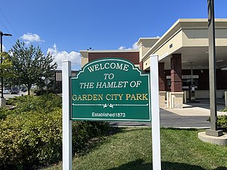
Garden City Park is a hamlet and census-designated place (CDP) located in the Town of North Hempstead in Nassau County, on Long Island, in New York, United States. The population was 7,806 at the 2010 census.
Addyston is a village in Miami Township, Hamilton County, Ohio, United States. Located along the Ohio River, it is a western suburb of the neighboring city of Cincinnati. The population was 927 at the 2020 census.
Deer Park is a city in Hamilton County, Ohio, United States. It is a suburb of Cincinnati. The population was 5,432 at the 2020 census.
Montgomery is a city in Hamilton County, Ohio, United States. It is an eastern suburb of Cincinnati. The population was 10,853 at the 2020 census.
Springdale is a city in Hamilton County, Ohio, United States. It is a suburb of Cincinnati. The population was 11,007 at the 2020 census.
Willowick is a city in Lake County, Ohio, United States, on Lake Erie. The population was 14,204 at the 2020 census. A suburb of Cleveland, Willowick is served by a branch of the Willoughby-Eastlake Public Library. The city's name is a portmanteau of two adjacent cities, Willoughby and Wickliffe. As of 2022, the mayor of Willowick is Michael Vanni.
Northridge is an unincorporated community in Harrison Township in Montgomery County, Ohio, United States. It was delineated as a census-designated place (CDP) for the 2000 census, at which time its population was 8,487. It is located directly north of the city of Dayton and is part of the Dayton Metropolitan Statistical Area.
Riverside is a city in Montgomery County, Ohio, United States. The population was 24,474 at the 2020 census. A suburb of Dayton, it is part of the Dayton metropolitan area.
Pine Creek Township is a township in Jefferson County, Pennsylvania, United States. The population was 1,325 at the 2020 census. The township was named for the abundance of pine trees in the area.
Rose Township is a township in Jefferson County, Pennsylvania, United States. The population was 1,157 at the 2020 census. It was named for a prominent citizen named Dr. Rose.
Spry is a census-designated place (CDP) that is located in York County, Pennsylvania, United States. The population was 4,891 at the time of the 2010 census.
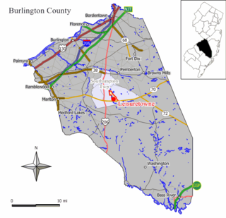
Sharonville is a city largely in Hamilton County in the U.S. state of Ohio. The population was 14,117 at the 2020 census.
Loveland Park is a census-designated place (CDP) located in Symmes Township, Hamilton County and Deerfield Township, Warren County, in the southwestern part of the U.S. state of Ohio. The CDP is named after the city of Loveland. The population was 1,737 at the 2020 census.
Rittman is a city in Medina and Wayne counties in the U.S. state of Ohio. All but a small portion of the city is in Wayne County, within commuting distance of Akron, Canton and Cleveland. The population was 6,131 at the 2020 census.