List of Lake Erie Islands

Last updated

Lake Erie Islands LakeErieIslands.JPG
Lake Erie Islands

The Lake Erie Islands are a chain of archipelagic islands in Lake Erie. They include Kelleys Island, Erie Island, [1] Pelee Island, the Bass Islands, and several others. The majority of these islands are under the sovereignty of the State of Ohio in the United States. Pelee Island is the only major inhabited island within the province of Ontario, while the smaller Middle Island is the southmost point of land in Canada.

Contents

Most of the larger islands are popular tourist attractions, served by car ferries running from the mainland and between some islands. Some small airports and numerous private marinas offer other ways for visitors to reach the islands. Combined with nearby Sandusky and Port Clinton, Ohio, the islands are part of the collective area known regionally as "Vacationland". [2]

Geology

Depth map showing the three basins of Lake Erie. The islands are in the westernmost, shallowest basin. Lake Erie and Lake Saint Clair bathymetry map.png
Depth map showing the three basins of Lake Erie. The islands are in the westernmost, shallowest basin.
Glacial grooves stemming from the Wisconsin glaciation at Kelleys Island, Ohio Glacial grooves.jpg
Glacial grooves stemming from the Wisconsin glaciation at Kelleys Island, Ohio

The Lake Erie Islands are geologically part of the Silurian Columbus Limestone. When the Pleistocene ice sheets carved out the basin of modern-day Lake Erie, these hard rocks proved more resistant to erosion than the shales in the east, and as a result, Lake Erie's western end is much shallower than the basins in the east, so that the islands remain above water. Quarrying operations on Kelleys Island revealed glacial grooves in the bedrock, which would in time be regarded as some of the best direct evidence of the Pleistocene ice sheets available anywhere. The glacial grooves are now protected as part of Kelleys Island State Park. [3] [4]

Economy

Most of the islands are supported financially via tourism. Grape growing and wineries were once the mainstay of the economy. Kelleys Island is heavily forested and woods have replaced vineyards there almost entirely. South Bass Island is more developed and still has a few vineyards. Pelee Island is the only major island where vineyards remain common. Limestone quarrying still occurs on Kelleys Island, and also there are a few hobby farms. South Bass, Middle Bass, North Bass, and Kelleys Islands all have active state parks part of the Ohio Department of Natural Resources with North Bass Island State Park being the largest at 593 acres and 90% of North Bass Island (also known as Isle St. George). [5]

Residents

Most of the islands are headed by a small group of year-round residents. However, eager vacationers often raise the populations dramatically during the summer months, most notable on South Bass Island, which is the most tourist-friendly of the islands despite its small size. The islands vary by year-round population of approximately 500 on South Bass Island, 100 for Kelleys Island, 40 at Middle Bass Island and 12 on North Bass Island.

Kelleys Island, Middle Bass, North Bass and South Bass (Put-in-Bay) have active school districts with North Bass Local School District being the last operating one-room schoolhouse in Ohio. [6] Of the islands with year-round residents, only North Bass has no ferry service. Put-in-Bay Township Port Authority operates public airports for Middle, North and South Bass Islands. [7] Kelleys Island and Pelee Island operate paved, public runways and Rattlesnake Island maintains a private grass landing strip.

Lake Erie islands

Map all coordinates using: OpenStreetMap  
Download coordinates as: KML
Map of the Lake Erie Islands. Lake Erie Islands Map.png
Map of the Lake Erie Islands.
Alvar habitat on Kelleys Island. Perry's Victory and International Peace Memorial is barely visible in the distance on neighboring South Bass Island Alvar4.jpg
Alvar habitat on Kelleys Island. Perry's Victory and International Peace Memorial is barely visible in the distance on neighboring South Bass Island
Green Island from the air, with South Bass Island in the foreground Green Island, Lake Erie, from the air.jpg
Green Island from the air, with South Bass Island in the foreground
NameState/ProvinceArea
sq. mi. [8] (km²) [9]
LocationInhabited? [10]
Pelee Island Ontario16.140 sq. mi. (41.79 km²) 41°46′00″N82°38′27″W / 41.7667°N 82.6409°W / 41.7667; -82.6409 (Pelee Island) Yes
Kelleys Island Ohio4.41 sq. mi. (11.42 km²) 41°36′05″N82°41′51″W / 41.601389°N 82.6975°W / 41.601389; -82.6975 (Kelleys Island) Yes
South Bass Island Ohio2.482 sq. mi. (6.428 km²) 41°38′59″N82°49′08″W / 41.6497°N 82.8189°W / 41.6497; -82.8189 (South Bass Island) Yes
Middle Bass Island Ohio1.258 sq. mi. (3.258 km²) 41°40′45″N82°48′40″W / 41.679167°N 82.811111°W / 41.679167; -82.811111 (Middle Bass Island) Yes
North Bass Island Ohio1.076 sq. mi. (2.786 km²) 41°43′00″N82°49′00″W / 41.716667°N 82.816667°W / 41.716667; -82.816667 (North Bass Island) Yes
Johnson's Island Ohio0.469 sq. mi. (1.215 km²) 41°29′47″N82°44′05″W / 41.4963°N 82.7346°W / 41.4963; -82.7346 (Johnson's Island) Yes
Rattlesnake Island Ohio0.133 sq. mi. (0.344 km²) 41°40′45″N82°50′57″W / 41.6791°N 82.8493°W / 41.6791; -82.8493 (Rattlesnake Island) Yes
West Sister Island Ohio0.120 sq. mi. (0.311 km²) 41°44′23″N83°06′19″W / 41.739722°N 83.105278°W / 41.739722; -83.105278 (West Sister Island) No Longer
Middle Island Ontario0.072 sq. mi. (0.186 km²) 41°40′57″N82°41′04″W / 41.6825°N 82.684444°W / 41.6825; -82.684444 (Middle Island) No Longer
East Sister Island Ontario0.058 sq. mi. (0.150 km²) 41°48′47″N82°51′23″W / 41.813056°N 82.856389°W / 41.813056; -82.856389 (East Sister Island) No
Sugar Island Ohio0.047 sq. mi. (0.123 km²) 41°41′31″N82°49′34″W / 41.692°N 82.826°W / 41.692; -82.826 (Sugar Island) Yes
Green Island Ohio0.027 sq. mi. (0.069 km²) 41°38′44″N82°51′54″W / 41.6456°N 82.8651°W / 41.6456; -82.8651 (Green Island) No Longer
Ballast Island Ohio0.019 sq. mi. (0.049 km²) 41°40′40″N82°47′07″W / 41.6778°N 82.7853°W / 41.6778; -82.7853 (Ballast Island) Yes
Mouse Island Ohio 41°35′28″N82°49′59″W / 41.59111°N 82.83306°W / 41.59111; -82.83306 (Mouse Island) No Longer
Gibraltar Island Ohio0.010 sq. mi. (0.026 km²) 41°39′30″N82°49′14″W / 41.6582°N 82.8206°W / 41.6582; -82.8206 (Gibraltar Island) Yes
Indian Island Michigan 41°45′08″N83°23′27″W / 41.752202°N 83.390962°W / 41.752202; -83.390962 (Indian Island) No
Hen Island and her "Chickens":
Big Chicken, Chick, and Little Chicken islands
Ontario 41°47′18″N82°47′51″W / 41.788333°N 82.7975°W / 41.788333; -82.7975 (Hen Island) Hen Yes, the "chickens" No
Middle Sister Island Ontario0.015 sq. mi. (0.039 km²) 41°50′55″N83°00′03″W / 41.8487°N 83.0007°W / 41.8487; -83.0007 (Middle Sister Island) No Longer
North Harbour Island Ontario 41°49′30″N82°51′36″W / 41.825°N 82.86°W / 41.825; -82.86 (North Harbour Island) Yes
Turtle Island Michigan/Ohio0.002 sq. mi. (0.005 km²) 41°45′09″N83°23′28″W / 41.7525°N 83.391111°W / 41.7525; -83.391111 (Turtle Island) No Longer
Ryerson's Island Ontario 42°36′08″N80°16′54″W / 42.602358°N 80.281611°W / 42.602358; -80.281611 (Ryerson's Island) Yes
Second Island Ontario 42°35′24″N80°16′15″W / 42.589883°N 80.270843°W / 42.589883; -80.270843 (Second Island) No
Starve Island Ohio0.003 sq. mi. (0.008 km²) 41°37′36″N82°49′21″W / 41.626667°N 82.8225°W / 41.626667; -82.8225 (Starve Island) No
Buckeye Island Ohio 41°39′53″N82°47′25″W / 41.6648°N 82.7904°W / 41.6648; -82.7904 (Buckeye Island) No
Lost Ballast Island Ohio 41°40′32″N82°47′11″W / 41.675475°N 82.786383°W / 41.675475; -82.786383 (Lost Ballast Island) No
Snow Island Ontario 42°34′47″N80°15′33″W / 42.579731°N 80.259129°W / 42.579731; -80.259129 (Snow Island) No
Mohawk Island (formerly Gull Island) Ontario0.015 sq. mi. (0.039 km²) 42°50′02″N79°31′21″W / 42.833889°N 79.5225°W / 42.833889; -79.5225 (Mohawk Island) No Longer
Gull Island, Ohio Ohio 41°39′35″N82°41′14″W / 41.659761°N 82.687328°W / 41.659761; -82.687328 (Gull Island) No [11]
Catawba Island
(former island) [12]
Ohio5.700 sq. mi. (14.8 km²) 41°33′49″N82°50′20″W / 41.563611°N 82.838889°W / 41.563611; -82.838889 (Catawba Island) Yes
Gard Island Michigan 41°45′00″N83°26′32″W / 41.750064°N 83.44212°W / 41.750064; -83.44212 (Gard Island) No Longer
Presque Island
(former island)
Pennsylvania4.863 sq. mi. (12.594 km²) 42°09′47″N80°06′03″W / 42.163056°N 80.100833°W / 42.163056; -80.100833 (Presque Island) Yes
Kafralu Island Ohio 41°27′53″N82°40′25″W / 41.464719°N 82.673476°W / 41.464719; -82.673476 (Kafralu Island) No Longer
Bird Island New York 42°53′43″N78°54′24″W / 42.895333°N 78.906722°W / 42.895333; -78.906722 (Squaw Island) No


See also

Related Research Articles

Lake Erie One of the Great Lakes in North America

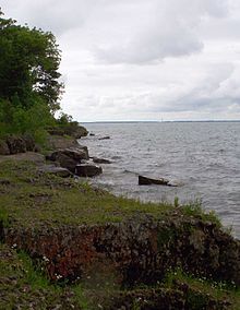
Lake Erie ( "eerie") is the fourth largest lake of the five Great Lakes in North America and the eleventh-largest globally. It is the southernmost, shallowest, and smallest by volume of the Great Lakes and therefore also has the shortest average water residence time. At its deepest point Lake Erie is 210 feet (64 m) deep.

Kelleys Island, Ohio Village in Ohio, United States

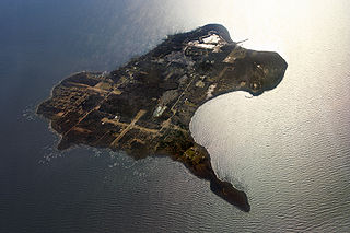
Kelleys Island is both a village in Erie County, Ohio, and the island which it fully occupies in Lake Erie. The British originally called it Sandusky Island. Later the United States took it over and officially designated it as Island Number 6 and Cunningham Island. It was renamed as Kelleys Island in 1840 by brothers Datus and Irad Kelley, who had purchased nearly the entire island.

Marblehead, Ohio Village in Ohio, United States

Marblehead is a village in Ottawa County, Ohio, United States. The population was 903 at the 2010 census.

Port Clinton, Ohio City in Ohio, United States

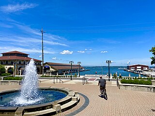
Port Clinton is a city in and the county seat of Ottawa County, located at the mouth of the Portage River on Lake Erie, about 44 miles east of Toledo. The population was 6,056 at the 2010 census.

Niagara Escarpment Escarpment in Canada and the United States

The Niagara Escarpment is a long escarpment, or cuesta, in Canada and the United States that runs predominantly east–west from New York through Ontario, Michigan, Wisconsin, and Illinois. The escarpment is most famous as the cliff over which the Niagara River plunges at Niagara Falls, for which it is named.

Bass Islands Group of limestone islands in Lake Erie, Ohio

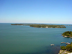
The Bass Islands are three American islands in the western half of Lake Erie. They are north of Sandusky, Ohio, and south of Pelee Island, Ontario. South Bass Island is the largest of the islands, followed closely by North Bass Island and Middle Bass Island. They are located in Put-in-Bay Township, Ottawa County in the state of Ohio. Historically Middle Bass has also been called Ile de Fleurs and North Bass was known as Isle St. George.

Pelee, Ontario Township in Ontario, Canada

Pelee Island, Ontario, Canada, is an island in the western half of Lake Erie. Pelee Island is connected to the Canadian and United States mainland by ferry service. At 42 km2 (16 sq mi), Pelee Island is the largest island in Lake Erie and the southernmost populated point in Canada. An Ontario Historical Plaque was erected by the province to commemorate the development of Pelee Island's role in Ontario's heritage. Nearby Middle Island is the southernmost point of land in Canada.

Kelleys Island State Park Park in Ohio, USA

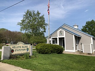
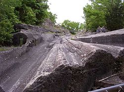
Kelleys Island State Park is a public recreation area occupying one-quarter of Kelleys Island, an island in Lake Erie located 13 miles (21 km) northeast of Port Clinton, Ohio, in the United States. The state park's 677 acres (274 ha) include six miles (9.7 km) of hiking trails, ruins of lime kilns and quarrying operations, sand beach, and campground. The park was established in 1956. The park cooperates with other agencies to manage the adjoining Glacial Grooves State Memorial, a set of rare glacial grooves, North Shore Alvar State Natural Area, a rare alvar habitat, and the North Pond State Nature Preserve, a lake embayment usually separated from the lake by a sand bar.

Early Lake Erie Body of water

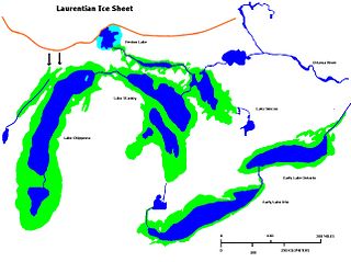
Early Lake Erie was a prehistoric proglacial lake that existed at the end of the last ice age approximately 13,000 years ago. The early Erie fed waters to Glacial Lake Iroquois.

Catawba Island Township, Ottawa County, Ohio Township in Ohio, United States

Catawba Island Township is one of the twelve townships of Ottawa County, Ohio, United States. The 2000 census found 3,157 people in the township.

Sandusky, Ohio City in Erie County, Ohio, United States

Sandusky is a city in the U.S. state of Ohio and the county seat of Erie County. Situated in northern Ohio on the shores of Lake Erie, Sandusky is located roughly midway between Toledo and Cleveland.

Vacationland (Ohio)

The Vacationland region of Ohio - billed as such for being known primarily as a major summertime tourist destination - is the area that is generally considered to be in the north central part of the state, and along the western half of the Lake Erie shoreline, specifically the counties of Erie, Huron, Ottawa, and Sandusky.

The geology of Ohio formed beginning more than one billion years ago in the Proterozoic eon of the Precambrian. The igneous and metamorphic crystalline basement rock is poorly understood except through deep boreholes and does not outcrop at the surface. The basement rock is divided between the Grenville Province and Superior Province. When the Grenville Province crust collided with Proto-North America, it launched the Grenville orogeny, a major mountain building event. The Grenville mountains eroded, filling in rift basins and Ohio was flooded and periodically exposed as dry land throughout the Paleozoic. In addition to marine carbonates such as limestone and dolomite, large deposits of shale and sandstone formed as subsequent mountain building events such as the Taconic orogeny and Acadian orogeny led to additional sediment deposition. Ohio transitioned to dryland conditions in the Pennsylvanian, forming large coal swamps and the region has been dryland ever since. Until the Pleistocene glaciations erased these features, the landscape was cut with deep stream valleys, which scoured away hundreds of meters of rock leaving little trace of geologic history in the Mesozoic and Cenozoic.

The geology of Kentucky formed beginning more than one billion years ago, in the Proterozoic eon of the Precambrian. The oldest igneous and metamorphic crystalline basement rock is part of the Grenville Province, a small continent that collided with the early North American continent. The beginning of the Paleozoic is poorly attested and the oldest rocks in Kentucky, outcropping at the surface, are from the Ordovician. Throughout the Paleozoic, shallow seas covered the area, depositing marine sedimentary rocks such as limestone, dolomite and shale, as well as large numbers of fossils. By the Mississippian and the Pennsylvanian, massive coal swamps formed and generated the two large coal fields and the oil and gas which have played an important role in the state's economy. With interludes of terrestrial conditions, shallow marine conditions persisted throughout the Mesozoic and well into the Cenozoic. Unlike neighboring states, Kentucky was not significantly impacted by the Pleistocene glaciations. The state has extensive natural resources, including coal, oil and gas, sand, clay, fluorspar, limestone, dolomite and gravel. Kentucky is unique as the first state to be fully geologically mapped.

The geology of Estonia is the study of rocks, minerals, water, landforms and geologic history in Estonia. The crust is part of the East European Craton and formed beginning in the Paleoproterozoic nearly two billion years ago. Shallow marine environments predominated in Estonia, producing extensive natural resources from organic matter such as oil shale and phosphorite. The Mesozoic and much of the Cenozoic are not well-preserved in the rock record, although the glaciations during the Pleistocene buried deep valleys in sediment, rechanneled streams and left a landscape of extensive lakes and peat bogs.

The geology of Wisconsin includes Precambrian crystalline basement rock over three billion years old. A widespread marine environment during the Paleozoic flooded the region, depositing sedimentary rocks which cover most of the center and south of the state.

The Bertie Group or Bertie Limestone, also referred to as the Bertie Dolomite and the Bertie Formation, is an upper Silurian geologic group and Lagerstätte in southern Ontario, Canada, and western New York State, United States. Details of the type locality and of stratigraphic nomenclature for this unit as used by the U.S. Geological Survey are available on-line at the National Geologic Map Database. The formation comprises dolomites, limestones and shales and reaches a thickness of 495 feet (151 m) in the subsurface, while in outcrop the group can be 60 feet (18 m) thick.

References

  1. "Climate of Erie Island, Ohio (zone 8b)". erieisland.simdif.com. Retrieved 2021-01-09.
  2. "Vacationland" history - Sandusky Library
  3. Publishers: (1) Lake Erie Coastal Ohio Trail National Scenic Byway (2) Ohio Chapter of The Nature Conservancy (3) Ohio Sea Grant; Editors: Art Weber, Melinda Huntley of the Ohio Sea Grant College Program, Explore the Lake Erie Islands Archived 2012-02-22 at the Wayback Machine , Retrieved September 1, 2014, (see page 5) "...Lake Erie’s shallow, nutrient-rich western basin and the much deeper central and eastern basins....The western basin... dolomite and limestone are more durable than the softer shales ... glacier dug through the stones ... resistance from the dolomite and limestone in the western basin..."
  4. "Kelleys Island State Park" . Retrieved 2017-01-07.
  5. "North Bass Island State Park". parks.ohiodnr.gov. Retrieved 2019-08-09.
  6. "7th Generation: Return of the Native: Restoring North Bass Island". ideastream. 2004-07-22. Retrieved 2019-08-09.
  7. "Home". Put-in-Bay Twp Port Authority. Retrieved 2019-08-09.
  8. Land Area - Census.gov
  9. Land Area - Statcan.gc.ca
  10. Population - Middle Bass 2.org
  11. "Lake Erie Island Sites". Middle Bass on the Web. Retrieved 2008-10-25.
  12. "Catawba Island, the Great Peach Growing Center of Ohio" (PDF). Retrieved March 6, 2014.