
The Gulf of St. Lawrence fringes the shores of the provinces of Quebec, New Brunswick, Nova Scotia, Prince Edward Island, Newfoundland and Labrador, in Canada, plus the islands Saint-Pierre and Miquelon, possessions of France, in North America.

Thunder Bay is a city in and the seat of Thunder Bay District, Ontario, Canada. It is the most populous municipality in Northwestern Ontario and the second most populous municipality in Northern Ontario. Its population is 108,843 according to the 2021 Canadian census. Located on Lake Superior, the census metropolitan area of Thunder Bay has a population of 123,258 and consists of the city of Thunder Bay, the municipalities of Oliver Paipoonge and Neebing, the townships of Shuniah, Conmee, O'Connor, and Gillies, and the Fort William First Nation.
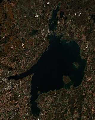
Lake Simcoe is a lake in southern Ontario, Canada, the fourth-largest lake wholly in the province, after Lake Nipigon, Lac Seul, and Lake Nipissing. At the time of the first European contact in the 17th century, the lake was called Ouentironk by the native Wendat/Ouendat (Huron) people. It was also known as Lake Taronto until it was renamed by John Graves Simcoe, the first Lieutenant-Governor of Upper Canada, in memory of his father, Captain John Simcoe of the Royal Navy. In Anishinaabemowin, the historical language of the First Nations living around this lake, namely Anishinaabek of Rama and Georgina Island First Nations, the lake is called Zhooniyaang-zaaga'igan, meaning "Silver Lake".

Georgian Bay is a large bay of Lake Huron, in the Laurentia bioregion. It is located entirely within the borders of Ontario, Canada. The main body of the bay lies east of the Bruce Peninsula and Manitoulin Island. To its northwest is the North Channel.

The Trans Canada Trail is a cross-Canada system of greenways, waterways, and roadways that stretches from the Atlantic to the Pacific to the Arctic oceans. The trail extends over 28,000 km (17,000 mi); it is now the longest recreational, multi-use trail network in the world. The idea for the trail began in 1992, shortly after the Canada 125 celebrations. Since then it has been supported by donations from individuals, corporations, foundations, and all levels of government.
Port Arthur was a city in Northern Ontario, Canada, located on Lake Superior. In January 1970, it amalgamated with Fort William and the townships of Neebing and McIntyre to form the city of Thunder Bay.

Lake Nipigon is part of the Great Lakes drainage basin. It is the largest lake entirely within the boundaries of the Canadian province of Ontario.
The Albany River is a river in Northern Ontario, Canada, which flows northeast from Lake St. Joseph in Northwestern Ontario and empties into James Bay. It is 982 kilometres (610 mi) long to the head of the Cat River, tying it with the Severn River for the title of longest river entirely in Ontario. Major tributaries include the Kenogami River and Ogoki River.

King's Highway 61, commonly referred to as Highway 61 and historically known as the Scott Highway, is a provincially maintained highway in the Canadian province of Ontario. The 61-kilometre (38 mi) route connects the Pigeon River Bridge, where it crosses into the United States and becomes Minnesota State Highway 61, with a junction at Highway 11, Highway 17 and the Harbour Expressway in Thunder Bay. The highway forms part of the Lake Superior Circle Tour.

Silver Islet refers to both a small rocky island and a small community located at the tip of the Sibley Peninsula in northwestern Ontario, Canada.

The Sibley Peninsula is a 52-kilometre (32 mi) long and 10-kilometre (6 mi) wide peninsula in Ontario, Canada, on Lake Superior. It projects into the lake from Superior's north shore, and separates Thunder Bay to the west from Black Bay to the east.

Sleeping Giant Provincial Park, established in 1944 as Sibley Provincial Park and renamed in 1988, is a 244-square-kilometre (94 sq mi) park located on the Sibley Peninsula in Northwestern Ontario, east of Thunder Bay. The nearest communities are Pass Lake, in the township of Sibley, located at the northern entrance to the park, and Dorion, located 35 kilometres (22 mi) northwest, in the township of Shuniah. The seasonal community of Silver Islet is located on the southern tip of the peninsula. The primary feature of the park is the Sleeping Giant, which is most visible from the city of Thunder Bay.

The North Shore of Lake Superior runs from Duluth, Minnesota, United States, at the western end of the lake, to Thunder Bay and Nipigon, Ontario, Canada, in the north, to Sault Ste. Marie, Ontario in the east. The shore is characterized by alternating rocky cliffs and cobblestone beaches, with forested hills and ridges through which scenic rivers and waterfalls descend as they flow to Lake Superior.

Rossport is a dispersed rural community and unincorporated place in the Unorganized part of Thunder Bay District in northwestern Ontario, Canada. It is on the north shore of Lake Superior in geographic Lahontan Township, and is on Ontario Highway 17. Rossport is a designated place served by a local services board, and has a population of 65.
Lake Superior National Marine Conservation Area is a National Marine Conservation Area (NMCA) on the north shore of Lake Superior in Ontario, and is a unit of the national park system. Established on September 1, 2015, it is the largest freshwater marine protected area in the world.

Michigan consists of two peninsulas surrounded primarily by four of the Great Lakes and a variety of nearby islands. The Upper Peninsula is bounded on the southwest by Wisconsin, and the Lower Peninsula is bounded on the south by Indiana and Ohio. Both land masses are also separated from the Canadian province of Ontario by waterways of the Great Lakes, and from each other by the Straits of Mackinac. Because its land is largely surrounded by the Great Lakes, which flow into the Saint Lawrence River, Michigan is the only U.S. state whose streams and rivers are almost entirely within the Great Lakes-St. Lawrence watershed.
Lac des Mille Lacs is a lake in the western part of Thunder Bay District in northwestern Ontario, Canada. It is in the Nelson River drainage basin and is the source of the Seine River. The lake lies between Ontario Highway 17 on the north and Ontario Highway 11 on the south about 100 kilometres (62 mi) west of the city of Thunder Bay.
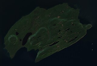
Pie Island is an island in Lake Superior, Ontario, Canada, located about 10 kilometres (6.2 mi) south of Thunder Bay and 25 kilometres (16 mi) north of Isle Royale, Michigan. It is about 12 kilometres (7.5 mi) long with an area of 46 square kilometres (18 sq mi). Pie Island is readily visible from the shoreline and high parts of the city of Thunder Bay.
Black Bay Peninsula is a volcanic peninsula in Unorganized Thunder Bay District in Northwestern Ontario, Canada, located on the North Shore of Lake Superior. It separates Black Bay and Nipigon Bay and consists of over 300 flood basalt lava flows. Porphyry Island, an island entirely encompassed within Porphyry Island Provincial Park, lies off the tip of the peninsula. A 49-square-kilometre (19 sq mi) portion of the peninsula has been set aside as the Black Bay Peninsula Enhanced Management Area.

Turgeon Lake is a freshwater body located in the Northwest province of Quebec, in Canada. This body of water straddles the municipalities of:


