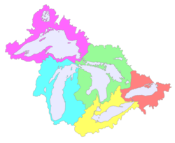
A map of the Great Lakes Basin showing the five sub-basins within. Left to right they are: Superior (magenta); Michigan (cyan); Huron (pale green); Erie (yellow); Ontario (light coral).
Each individual lake forms a sub-basin, such as the Lake Erie Basin, and each sub-basin consists of multiple watersheds, such as Pennsylvania's Lake Erie Watershed. The overall Great Lakes Basin is monitored by the binational Great Lakes Commission.
St. Lawrence Basin
Quebec, a portion of whose lands drain into the St. Lawrence Basin, is a signatory to the Great Lakes Charter of 1985, the 2001 Charter Annex, and the Agreements of 2005.[2] While not a part of the Great Lakes Basin, Quebec's position along the Saint Lawrence Seaway makes it a partner in water resource management with Ontario and the eight US states mentioned above.
This page is based on this Wikipedia article Text is available under the CC BY-SA 4.0 license; additional terms may apply. Images, videos and audio are available under their respective licenses.