St. Lawrence River

Last updated

St. Lawrence River
Saint Lawrence River
Le fleuve Saint-Laurent.jpg
Grlakes lawrence map.png
Great Lakes/St. Lawrence watershed
Etymology Saint Lawrence of Rome
Location
CountryCanada, United States
Provinces Ontario, Quebec
State New York
Physical characteristics
Source Lake Ontario
  location Kingston, Ontario / Cape Vincent, New York
  coordinates 44°06′N76°24′W / 44.100°N 76.400°W / 44.100; -76.400
  elevation74.7 m (245 ft)
Mouth Gulf of St. Lawrence / Atlantic Ocean
  location
Quebec, Canada
  coordinates
49°30′N64°30′W / 49.500°N 64.500°W / 49.500; -64.500
  elevation
0 m (0 ft)
Length500 km (310 mi) excluding the estuary. C. 928 km if included. (St. Lawrence RiverLake OntarioNiagaraLake ErieDetroitLake St. ClairSt. ClairLake HuronSt. Marys RiverLake SuperiorSt. LouisNorth River: 3,058 km) [1] [2]
Basin size1,344,200 km2 (519,000 sq mi) [3] (Pointe-des-Monts: 1,271,547.4 km2) [4]
Width 
  average1–5 km (0.62–3.11 mi) [5]
Depth 
  minimum2 m (6 ft 7 in) (Fluvial Section) [5]
  maximum60 m (200 ft) (Quebec City) [5]
Discharge 
  location Pointe-des-Monts
  average(Period: 1969–2023)17,600 m3/s (620,000 cu ft/s) [6]
  minimum10,478 m3/s (370,000 cu ft/s) [6]
  maximum33,085 m3/s (1,168,400 cu ft/s) [6]
Discharge 
  location Tadoussac
  average(Period: 1962–1988)16,800 m3/s (590,000 cu ft/s) [7]
Discharge 
  location Quebec City
  average(Period: 1968–2023)12,500 m3/s (440,000 cu ft/s) [6]
  minimum8,600 m3/s (300,000 cu ft/s) [6]
  maximum22,766 m3/s (804,000 cu ft/s) [6]
Discharge 
  location Montreal
  average(Period: 1971–2000)10,063.3 m3/s (355,380 cu ft/s) [4]
Discharge 
  location Cornwall
  average(1861–2019)7,060 m3/s (249,000 cu ft/s) [6]
Basin features
Progression Gulf of St. Lawrence
River system St. Lawrence River

The St. Lawrence River (French : Fleuve Saint-Laurent) is a large international river in the middle latitudes of North America connecting the Great Lakes to the North Atlantic Ocean. Its waters flow in a northeasterly direction from Lake Ontario to the Gulf of St. Lawrence, traversing Ontario and Quebec in Canada and New York in the United States. A section of the river demarcates the Canada–U.S. border.

Contents

As the primary drainage outflow of the Great Lakes Basin, the St. Lawrence has the second-highest discharge of any river in North America (after the Mississippi River) and the 16th-highest in the world. The estuary of St. Lawrence is often cited by scientists as the largest in the world. Significant natural landmarks of the river and estuary include the 1,864 river islands of the Thousand Islands, the endangered whales of Saguenay–St. Lawrence Marine Park, and the limestone monoliths of the Mingan Archipelago.

Long a transportation route to Indigenous peoples, the St. Lawrence River has played a key role in the history of Canada and in the development of cities such as Montreal and Quebec City. The river remains an important shipping route as the backbone of the St. Lawrence Seaway, a lock and canal system that enables world marine traffic to access the inland ports of the Great Lakes Waterway.
Etymology

The river has been called a variety of names by local First Nations. Beginning in the 16th century, French explorers visited what is now Canada and gave the river names such as the Grand fleuve de Hochelaga and the Grande rivière du Canada, [8] where fleuve and rivière are two French words (fleuve being a river that flows into the sea).

The river's present name has been used since 1604 when it was recorded on a map by Samuel de Champlain [8] Champlain opted for the names Grande riviere de sainct Laurens and Fleuve sainct Laurens in his writings, supplanting the earlier names. [8] In contemporary French, the name is rendered as the fleuve Saint-Laurent. The name Saint-Laurent (Saint Lawrence) was originally applied to the eponymous bay by Jacques Cartier upon his arrival into the region on the 10th of August feast day for Saint Lawrence in 1535. [8]

Today, the river is still known by Indigenous nations by a number of distinct names. Innu-aimun, the language of Nitassinan, refers to it as Wepistukujaw Sipo/Wepìstùkwiyaht sīpu; [8] [9] the Abenaki call it Moliantegok/Moliantekw ("Montréal River"), [8] Kchitegw/Ktsitekw/Gicitegw ("Great River"), [9] or Oss8genaizibo/Ws8genaisibo/Wsogenaisibo ("River of the Algonquins"); [9] the Mohawk refer to it in Kanienʼkéha as Roiatatokenti, Raoteniateara, [8] Ken’tarókwen, [10] or Kaniatarowanénhne; [11] the Tuscarora call it Kahnawáˀkye or Kaniatarowanenneh ("Big Water Current"); [12] the Algonquins (or Omàmiwininiwak) call it "the Walking Path" or Magtogoek [8] [13] or Kitcikanii sipi, the "Large Water River"; [9] [14] the Huron-Wendats refer to it as Lada8anna or Laooendaooena; [9] and, the Atikamekw of Nitaskinan refer to it as Micta sipi ("Huge River").

Geography

Boats of the Transat Quebec-Saint-Malo on the St. Lawrence River in 2000 000730 15a 3545 2367 fleuve I Orleans.jpg
Boats of the Transat Québec–Saint-Malo on the St. Lawrence River in 2000
Cross commemorating the one laid by Jacques-Cartier on October 7, 1535, Trois-Rivieres Ile St Quentin 021.jpg
Cross commemorating the one laid by Jacques-Cartier on October 7, 1535, Trois-Rivières
The Champlain Sea Champlain Sea 1.png
The Champlain Sea

Marine weather

In winter, the St. Lawrence River begins producing ice in December, with the formation of ice cubes between Montreal and Quebec City. The prevailing winds and currents push this ice towards the estuary, [15] and it reaches the east of Les Méchins at the end of December. Ice covers the entire Gulf of St. Lawrence in January and February.

Ice helps navigation by preventing the formation of waves, and therefore spray, and prevents the icing of ships. [16]

Watershed

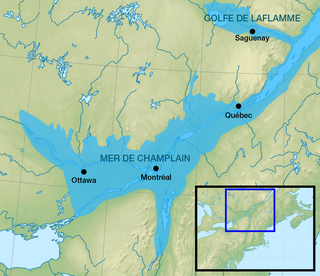
With the draining of the Champlain Sea, due to a rebounding continent from the Last Glacial Maximum, the St. Lawrence River was formed. The Champlain Sea lasted from about 13,000 years ago to about 10,000 years ago and was continuously shrinking during that time, a process that continues today. [17] [18] The head of the St. Lawrence River, near Lake Ontario, is home to the Thousand Islands. [19]

Today, the St. Lawrence River begins at the outflow of Lake Ontario and flows adjacent to Gananoque, Brockville, Morristown, Ogdensburg, Massena, Cornwall, Montreal, Trois-Rivières, and Quebec City before draining into the Gulf of St. Lawrence, often given as the largest estuary in the world. [20] The estuary begins at the eastern tip of Île d'Orléans, just downstream from Quebec City. [7] The river becomes tidal around Quebec City. [21]

The St. Lawrence River runs 3,058 kilometres (1,900  mi ) from the farthest headwater to the mouth and 1,197 km (743.8 mi) from the outflow of Lake Ontario. These numbers include the estuary; without the estuary, the length from Lake Ontario is c. 500 km (c. 300 mi). The farthest headwater is the North River in the Mesabi Range at Hibbing, Minnesota. Its drainage area, which includes the Great Lakes, the world's largest system of freshwater lakes, is 1,344,200 square kilometres (518,998.5 sq mi), of which 839,200 km2 (324,016.9 sq mi) is in Canada and 505,000 km2 (194,981.6 sq mi) is in the United States. The basin covers parts of Ontario and Quebec in Canada, parts of Minnesota, Wisconsin, Illinois, Indiana, Ohio, Pennsylvania, New York, Vermont, and nearly the entirety of the state of Michigan in the United States. The average discharge below the Saguenay River is 16,800 cubic metres per second (590,000 cu ft/s). At Quebec City, it is 12,101 m3/s (427,300 cu ft/s). The average discharge at the river's source, the outflow of Lake Ontario, is 7,410 m3/s (262,000 cu ft/s). [7]

The St. Lawrence River includes Lake Saint Francis at Salaberry-de-Valleyfield, Lake Saint-Louis south of Montreal and Lake Saint Pierre east of Montreal. It encompasses four archipelagoes: the Thousand Islands chain near Alexandria Bay, New York and Kingston, Ontario; the Hochelaga Archipelago, including the Island of Montreal and Île Jésus (Laval); the Lake St. Pierre Archipelago (classified a biosphere world reserve by the UNESCO in 2000) [22] and the smaller Mingan Archipelago. Other islands include Île d'Orléans near Quebec City and Anticosti Island north of the Gaspé. It is the second longest river in Canada.

Lake Champlain and the Ottawa, Richelieu, Saint-Maurice, Saint-François, Chaudière and Saguenay rivers drain into the St. Lawrence.

The St. Lawrence River is in a seismically active zone where fault reactivation is believed to occur along late Proterozoic to early Paleozoic normal faults related to the opening of the Iapetus Ocean. The faults in the area are rift-related and comprise the Saint Lawrence rift system.

According to the United States Geological Survey, the St. Lawrence Valley is a physiographic province of the larger Appalachian division, containing the Champlain section. [23] However, in Canada, where most of the valley is, it is instead considered part of a distinct St. Lawrence Lowlands physiographic division, and not part of the Appalachian division at all. [24]

Sources

The source of the North River in the Mesabi Range in Minnesota (Seven Beaver Lake) is considered to be the source of the St. Lawrence River. Because it crosses so many lakes, the water system frequently changes its name. From source to mouth, the names are:

The St. Lawrence River also passes through Lake Saint-Louis and Lake Saint-Pierre in Quebec.

Pont de l'ile 2.JPG
Looking downstream: Quebec City (left), St. Lawrence River, Île d'Orléans (center), Lévis (right), Laurentian Mountains (background).

Tributaries

The St. Lawrence River and the largest tributaries of the Great Lakes.

The St. Lawrence River tributaries are listed upstream from the mouth. The major tributaries of the inter-lake sections are also shown, as well as the major rivers that flow into the Great Lakes. Great Lakes tributaries are listed in alphabetical order.

The list includes all tributaries with a drainage area of at least 1,000 square kilometres and an average flow of more than 10 cubic metres per second.

Left

tributary

Right tributary Length (km) Basin size (km2) Average discharge (m3/s)
St. Lawrence River
Godbout 1121,930.144.4
Frankquelin 67.5582.912.1
Manicouagan 22145,9081,020
Outardes 49919,057400
Mitis 511,806.437
Betsiamites 44418,984.1366.7
Laval 42641.613
Rivière du Sault aux Cochons 1281,94638.7
Rimouski 119.21,63530.8
Portneuf 552,457.652.3
Rivière des Escoumins84810.517.5
Rivière des Trois-Pistoles 4396618.4
Verte 507.910.2
Saguenay 17087,635.41,893.9
Rivière du Loup 101.31,05918.5
Malbaie 1611,861.139.1
Rivière-Ouelle 73.4850.616.8
Rivière du Gouffre 76.11,010.123.5
Montmagny (Rivière du Sud)86.51,994.646.7
Sainte-Anne 971,07731.5
Montmorency 103.71,157.635.6
Saint-Charles 25483.413.6
Etchemin 1241,443.434.5
Chaudière 1856,682146.4
Jacques-Cartier 1782,51571.3
Rivière du Chêne 80.6855.921.1
Sainte-Anne 1232,753.373.4
Batiscan 1964,690107.1
Bécancour 2102,60763.2
Saint-Maurice 56341,994.3730
Nicolet 1373,38077.8
Rivière du Loup1021,642.927.8
Saint François 21810,230237.8
Yamaska 1604,784110.1
Maskinongé 401,205.721.3
Richelieu 12423,717.7455.8
L'Assomption 2004,22078.6
Ottawa 1,271147,405.81,948.8
Châteauguay 1212,466.743.8
Rivière aux Saumons 70.61,065.220.2
St. Regis River 1382,219.644
Raquette 2353,25074.4
Grasse 1171,657.932.9
Oswegatchie 2204,12088.3
Gananoque 909.512.2
Niagara
Tonawanda Creek 1401,70027.2
Detroit
Rouge 2041,58010.7
St. Clair River
Sydenham 1652,727.614.3
Belle 118.3556.44.4
Black 130.41,821.99.2
Great Lakes
Lake Ontario
Black 2014,964.8159.5
Credit 901,0008.1
Genesee 2536,507.7107.5
Humber 1001,008.47.5
Moira 982,73632.6
Napanee 601,099.212.6
Niagara 58682,350.95,885
Oak Orchard 95.2804.313
Oswego 3813,266255
Salmon 1351,53418.2
Salmon 71820.521.9
Sandy Creek 53501.911
Trent 9013,014.7154.6
Welland 1401,136.48.7
Lake Erie
Black 681,2179.8
Buffalo 131,186.417.4
Cattaraugus Creek 1091,510.124
Cuyahoga 136.62,377.629
Detroit 45595,0525,300
Grand 2806,763.845
Grand 165.31,873.623.8
Huron 2102,145.220.4
Huron 241,055.68.8
Maumee 22016,460164.1
Portage 66.81,574.611.3
Raisin 2242,78022.8
Sandusky 2143,262.126.1
Lake St. Clair
Clinton 1341,970.919.8
St. Clair River 65.2583,508.75,200
Thames 2735,82552.9
Lake Huron
Au Gres 75.21,2627.2
Au Sable 2225,468.536.4
Ausable 641,1428.1
Cheboygan 613,880.132.5
French 11019,100207
Garden 1,061.714.6
Magnetawan 1753,041.924.7
Maitland 1502,59221.4
Mississagi 2669,270118
Musquash 294,591.743.7
Nottawasaga 1203,082.418.8
SaginawShiawassee 21615,525.6136.7
St. Marys River 119.9211,833.32,135
Sauble 1,109.77.6
Saugeen 1604,12081.8
Seguin 401,0239.7
Serpent1,49510.2
Severn 306,039.256.9
Spanish 33813,368.3150
Thessalon 1,125.48.3
Thunder Bay 121.33,382.119.2
Whitefish 1,318.97.2
Lake Michigan
Burns Waterway 35.61,033.28.9
Calumet 661,183.810
Cedar 1081,158.36.9
Elk 1211,379.512.5
Escanaba 842,39028.1
Ford 1741,414.710.7
Fox 32016,650143.8
Grand 40615,206.6143
Kalamazoo 2105,23052.8
Manistee 3104,60047.5
Manistique 114.63,78052.7
Manitowac 57.61,552.410.6
Menomonee 18710,56999.6
Milwaukee 1672,271.517.1
Muskegon 3487,029.860.8
Oconto 91.62,474.919.8
Pere Marquette 102.82,074.618
Peshtigo 2192,856.321.9
Shebaygan 1301,2268.8
St. Joseph River 34012,130142.2
White 381,45813
Lake Superior
Agawa 1021,057.829.1
Aguasabon 70964.316.8
Bad 119.62,659.844.7
Batchawana 951,396.136.7
Black 66.1724.315.1
Black Sturgeon 722,815.643.1
Brule 65699.710
Chipewa 40920.922.4
Dog 50.91,333.528
Goulais 702,07142.1
Gravel 700.112.1
Kaministiquia 957,903.199.4
Little Pic1,459.121
MagpieMichipicoten 817,446.7145.8
Montreal 1303,45284
Montreal 76.9861.912.8
Nemadji 113.91,158.418.6
Nipigon 4825,645.4383.6
Old Woman 558.810.9
Ontonagon 403,720.275.8
Pic 1886,430109.9
Pigeon 801,610.625.1
Presque Isle 67.81,088.920.3
Pukaskwa 801,308.324.6
Saint Louis 3099,410146.7
Sand 56537.713
Steel 1701,298.818.3
Sturgeon 1711,892.243.1
Tahquamenon 143.42,25846.3
Two Hearted 3857511.7
White 1405,228.395.7
Wolf 650.210
Source [4]

Discharge

YearAverage discharge [6]
Quebec City Pointe-des-Monts
200710,967 m3/s (387,300 cu ft/s)16,600 m3/s (590,000 cu ft/s)
200812,550 m3/s (443,000 cu ft/s)18,100 m3/s (640,000 cu ft/s)
200912,166 m3/s (429,600 cu ft/s)17,227 m3/s (608,400 cu ft/s)
201011,691 m3/s (412,900 cu ft/s)16,187 m3/s (571,600 cu ft/s)
201113,221 m3/s (466,900 cu ft/s)18,616 m3/s (657,400 cu ft/s)
201211,291 m3/s (398,700 cu ft/s)16,704 m3/s (589,900 cu ft/s)
201312,090 m3/s (427,000 cu ft/s)17,098 m3/s (603,800 cu ft/s)
201412,563 m3/s (443,700 cu ft/s)18,059 m3/s (637,700 cu ft/s)
201511,425 m3/s (403,500 cu ft/s)17,310 m3/s (611,000 cu ft/s)
201612,411 m3/s (438,300 cu ft/s)17,563 m3/s (620,200 cu ft/s)
201714,309 m3/s (505,300 cu ft/s)19,213 m3/s (678,500 cu ft/s)
201813,220 m3/s (467,000 cu ft/s)16,884 m3/s (596,300 cu ft/s)
201915,154 m3/s (535,200 cu ft/s)21,004 m3/s (741,700 cu ft/s)
202014,113 m3/s (498,400 cu ft/s)18,996 m3/s (670,800 cu ft/s)
202111,344 m3/s (400,600 cu ft/s)16,093 m3/s (568,300 cu ft/s)
202213,135 m3/s (463,900 cu ft/s)17,902 m3/s (632,200 cu ft/s)
202313,560 m3/s (479,000 cu ft/s)18,799 m3/s (663,900 cu ft/s)

Biodiversity

The diversity of the St. Lawrence River includes: [27]

Marine mammals

fin whales off Tadoussac Whale watching Tadoussac 11.jpg
fin whales off Tadoussac

Large marine mammals travel in all the seas of the earth, the research and observations of these giants concern fishermen and shipping industry, exercise a fascination and a keen interest for laymen and, subjects of endless studies for scientists from Quebec, Canada and around the world. [29] [30] [31]

Thirteen species of cetaceans frequent the waters of the estuary and the Gulf of St. Lawrence: [32]

  1. Northern bottlenose whale
  2. Delphinapterus leucas (Beluga Whale) [33] [34]
  3. Sperm whale
  4. Atlantic white-sided dolphin
  5. White-beaked dolphin
  6. Orca
  7. Long-finned pilot whale
  8. Phocoena phocoena (Harbour Porpoise)
  9. North Atlantic right whale [35]
  10. Common minke whale
  11. Blue whale [36]
  12. Humpback whale
  13. Fin whale

History

Map of 1543 showing Cartier's discoveries Dauphin Map of Canada - circa 1543 - Project Gutenberg etext 20110.jpg
Map of 1543 showing Cartier's discoveries
Basque settlements and sites dating from the 16th and 17th centuries Basques Newfoundland.gif
Basque settlements and sites dating from the 16th and 17th centuries
Watercolour (c. 1792) by Elizabeth Simcoe depicting a bend in the St. Lawrence River in Quebec A bend in the St. Lawrence, Quebec (I0006891).tif
Watercolour (c.1792) by Elizabeth Simcoe depicting a bend in the St. Lawrence River in Quebec

First Nations

Flowing through and adjacent to numerous Indigenous homelands, the river was a primary thoroughfare for many peoples. Beginning in Dawnland at the Gulf of St. Lawrence, the river borders Mi'kma'ki [37] in the South (what is today known as the Canadian Maritimes), and Nitassinan in the North, the national territory of the Innu people. [38] On the south shore beyond the Mi'kmaw district of Gespe'gewa'ki, [37] the river passes Wolastokuk (the Maliseet homeland), Pαnawαhpskewahki (the Penobscot homeland), and Ndakinna (the Abenaki homeland). [39] Continuing, the river passes through the former country of the St. Lawrence Iroquois and then three of the six homelands of the Haudenosaunee: the Mohawk or Kanienʼkehá꞉ka, the Oneida or Onyota'a:ka, and the Onondaga or Onöñda’gaga’. [39]

In the early 17th century, the Huron-Wendat Nation migrated from their original country of Huronia to what is now known as Nionwentsïo centred around Wendake. [40] [41] Nionwentsïo occupies both the north and south shores of the river, [40] overlapping with Nitassinan and the more western Wabanaki or Dawnland countries. [39] Adjacent on the north shore is the Atikamekw territorial homeland of Nitaskinan [42] [43] and, upstream, the further reaches of Anishinaabewaki, specifically the homelands of the Algonquin and Mississauga Nations. [39]

European exploration

The Norse explored the Gulf of St. Lawrence in the 11th century and were followed by fifteenth- and early sixteenth-century European mariners, such as John Cabot, and the brothers Gaspar and Miguel Corte-Real. The first European explorer known to have sailed up the St. Lawrence River itself was Jacques Cartier. At that time, the land along the river described as "about two leagues, a mountain as tall as a heap of wheat" was inhabited by the St. Lawrence Iroquoians. During Cartier's second voyage in 1535, because Cartier arrived in the estuary on Saint Lawrence's feast day 10 August, he named it the Gulf of Saint Lawrence. [44] [45]

The St. Lawrence River is today partly within the U.S. and as such is that country's sixth oldest surviving European place-name. [46]

Early colonists

The earliest regular Europeans in the area were the Basques, who came to the St Lawrence Gulf and River in pursuit of whales from the early 16th century. The Basque whalers and fishermen traded with indigenous Americans and set up settlements, leaving vestiges all over the coast of eastern Canada and deep into the St. Lawrence River. Basque commercial and fishing activity reached its peak before the Armada Invencible's disaster (1588), when the Basque whaling fleet was confiscated by King Philip II of Spain. Initially, the whaling galleons from Labourd were not affected by the Spanish defeat.

Until the early 17th century, the French used the name Rivière du Canada to designate the St. Lawrence upstream to Montreal and the Ottawa River after Montreal. The St. Lawrence River served as the main route for European exploration of the North American interior, first pioneered by French explorer Samuel de Champlain.

Colonial control

Control of the river was crucial to British strategy to capture New France in the Seven Years' War. Having captured Louisbourg in 1758, the British sailed up to Quebec the following year thanks to charts drawn up by James Cook. British troops were ferried via the St. Lawrence to attack the city from the west, which they successfully did at the Battle of the Plains of Abraham. The river was used again by the British to defeat the French siege of Quebec under the Chevalier de Lévis in 1760.

In 1809, the first steamboat to ply its trade on the St. Lawrence was built and operated by John Molson and associates, a scant two years after Fulton's steam-powered navigation of the Hudson River. The Accommodation with ten passengers made her maiden voyage from Montreal to Quebec City in 66 hours, for 30 of which she was at anchor. She had a keel of 75 feet, and a length overall of 85 feet. The cost of a ticket was eight dollars upstream, and nine dollars down. She had berths that year for twenty passengers. [47] Within a decade, daily service was available in the hotly-contested Montreal-Quebec route. [48]

Because of the virtually impassable Lachine Rapids, the St. Lawrence was once continuously navigable only as far as Montreal. Opened in 1825, the Lachine Canal was the first to allow ships to pass the rapids. An extensive system of canals and locks, known as the St. Lawrence Seaway, was officially opened on 26 June 1959 by Elizabeth II (representing Canada) and President Dwight D. Eisenhower (representing the United States). The Seaway (including the Welland Canal) now permits ocean-going vessels to pass all the way to Lake Superior. [49]

Modern Canada

During the Second World War, the Battle of the St. Lawrence involved submarine and anti-submarine actions throughout the lower St. Lawrence River and the entire Gulf of St. Lawrence, Strait of Belle Isle and Cabot Strait from May to October 1942, September 1943, and again in October and November 1944. During this time, German U-boats sank several merchant marine ships and three Canadian warships.

In the late 1970s, the river was the subject of a successful ecological campaign (called "Save the River"), originally responding to planned development by the United States Army Corps of Engineers. The campaign was organized, among others, by Abbie Hoffman. [50]

Grand canoe reception for the Prince of Wales on the St. Lawrence, 1860 Grand canoe reception given to the Prince of Wales on the St. Lawrence - ILN 1860.jpg
Grand canoe reception for the Prince of Wales on the St. Lawrence, 1860

See also

Related Research Articles

<span class="mw-page-title-main">St. Lawrence Seaway</span> Locks and canals in the US and Canada

The St. Lawrence Seaway is a system of locks, canals, and channels in Canada and the United States that permits oceangoing vessels to travel from the Atlantic Ocean to the Great Lakes of North America, as far inland as Duluth, Minnesota, at the western end of Lake Superior. The seaway is named for the St. Lawrence River, which flows from Lake Ontario to the Atlantic Ocean. Legally, the seaway extends from Montreal, Quebec, to Lake Erie, and includes the Welland Canal. Ships from the Atlantic Ocean are able to reach ports in all five of the Great Lakes, via the Great Lakes Waterway.
<span class="mw-page-title-main">Gulf of St. Lawrence</span> Outlet of the North American Great Lakes via the St. Lawrence River into the Atlantic Ocean

The Gulf of St. Lawrence fringes the shores of the provinces of Quebec, New Brunswick, Nova Scotia, Prince Edward Island, Newfoundland and Labrador, in Canada, plus the islands Saint-Pierre and Miquelon, possessions of France, in North America.

<span class="mw-page-title-main">Anticosti Island</span> Island in Gulf of St. Lawrence River, Quebec, Canada

Anticosti is an island located between the Jacques Cartier and Honguedo Straits, in the Gulf of St. Lawrence, in L'Île-d'Anticosti (Municipality), Minganie MRC, Côte-Nord, Quebec, Canada.

<span class="mw-page-title-main">Saguenay–St. Lawrence Marine Park</span> National marine conservation area in Quebec, Canada

The Saguenay–St. Lawrence Marine Park is a National Marine Conservation Area, one of three in the Canadian national park system, located where the Saguenay River meets the Maritime estuary of the St. Lawrence River. This park is jointly managed by Parks Canada and Sépaq. It is the first park in all of Canada to protect a purely marine environment, and covers a surface area of 1,245 km2. The area that is now the Saguenay–St. Lawrence Marine Park is a part of the Innue Essipit First Nation's land claim, and a treaty resulting from this claim could impact activities that are practiced within the park. The region surrounding the park is an important part of the history of Canada, being one of the first points of contact between Indigenous Peoples and European explorers and the birthplace of the intercontinental fur trade.

<span class="mw-page-title-main">Lake Saint Pierre</span> Lake in Quebec, Canada

Lake Saint Pierre is a lake in Quebec, Canada, a widening of the Saint Lawrence River between Sorel-Tracy and Trois-Rivières. It is located downstream, and northeast, of Montreal; and upstream, and southwest, of Quebec City. The end of the lake delimits the beginning of the estuary of Saint Lawrence.

<span class="mw-page-title-main">Geography of Quebec</span>

Located in the eastern part of Canada, and part of Central Canada, Quebec occupies a territory nearly three times the size of France or Texas. It is much closer to the size of Alaska. As is the case with Alaska, most of the land in Quebec is very sparsely populated. Its topography is very different from one region to another due to the varying composition of the ground, the climate, and the proximity to water. The Great Lakes–St. Lawrence Lowlands and the Appalachians are the two main topographic regions in southern Quebec, while the Canadian Shield occupies most of central and northern Quebec.

<span class="mw-page-title-main">Minganie Regional County Municipality</span> Regional county municipality in Quebec, Canada

Minganie is a regional county municipality on the north shore of the Gulf of St. Lawrence, in Côte-Nord region, Quebec, Canada, its territory includes Anticosti Island.

<span class="mw-page-title-main">Canada (New France)</span> French colony in North America from 1535 to 1763

Canada was a French colony within the larger territory of New France. It was claimed by France in 1535 during the second voyage of Jacques Cartier, in the name of the French king, Francis I. The colony remained a French territory until 1763, when it became a British colony known as the Province of Quebec.

<span class="mw-page-title-main">Côte-Nord</span> Region 09 in Québec, Canada

Côte-Nord is an administrative region of Quebec, on the Quebec-Labrador Peninsula, Canada.

<span class="mw-page-title-main">Quebec Route 138</span> Highway in Quebec

Route 138 is a major highway in the Canadian province of Quebec, following the entire north shore of the St. Lawrence River past Montreal to the temporary eastern terminus in Kegashka on the Gulf of St. Lawrence. The western terminus is in Elgin, at the border with New York State south-west of Montreal. Part of this highway is known as the Chemin du Roy, or King's Highway, which is one of the oldest highways in Canada.

<span class="mw-page-title-main">Les Escoumins</span> Municipality in Quebec, Canada

Les Escoumins is a municipality in La Haute-Côte-Nord Regional County Municipality in the Côte-Nord region of Quebec. It is located on the north shore of the maritime estuary of the St. Lawrence River.

<span class="mw-page-title-main">Havre-Saint-Pierre</span> Municipality in Quebec, Canada

Havre-Saint-Pierre is a municipality located on the north shore of the Gulf of St. Lawrence, in Côte-Nord region, Minganie RCM, Quebec, Canada.

The St. Lawrence Iroquoians were an Iroquoian Indigenous people who existed until about the late 16th century. They concentrated along the shores of the St. Lawrence River in present-day Quebec and Ontario, Canada, and in the American states of New York and northernmost Vermont. They spoke Laurentian languages, a branch of the Iroquoian family.

<span class="mw-page-title-main">Great Lakes–St. Lawrence Lowlands</span> Physiographic region in eastern Canada

The Great Lakes-St. Lawrence Lowlands, or simply St. Lawrence Lowlands, is a physiographic region of Eastern Canada that comprises a section of southern Ontario bounded on the north by the Canadian Shield and by three of the Great Lakes — Lake Huron, Lake Erie and Lake Ontario — and extends along the St. Lawrence River to the Strait of Belle Isle and the Atlantic Ocean. The lowlands comprise three sub-regions that were created by intrusions from adjacent physiographic regions — the West Lowland, Central Lowland and East Lowland. The West Lowland includes the Niagara Escarpment, extending from the Niagara River to the Bruce Peninsula and Manitoulin Island. The Central Lowland stretches between the Ottawa River and the St. Lawrence River. The East Lowland includes Anticosti Island, Îles de Mingan, and extends to the Strait of Belle Isle.

<span class="mw-page-title-main">Aguanish, Quebec</span> Municipality in Quebec, Canada


Aguanish is a municipality located on the banks of the Aguanish River, on the north shore of Jacques Cartier Strait, in the Gulf of St. Lawrence, in Minganie Regional County Municipality, Côte-Nord region, Quebec, Canada.

<span class="mw-page-title-main">Saguenay Fjord National Park</span> Provincial park in Quebec, Canada

Saguenay Fjord National Park is a provincial park located in Quebec, Canada. In the regions of Saguenay–Lac-Saint-Jean, Charlevoix, Côte-Nord, and Bas-Saint-Laurent, the park is situated along the eastern end of the Saguenay River and adjoins the Saguenay–St. Lawrence Marine Park for over 100 km (60 mi.).

<span class="mw-page-title-main">Champlain Sea</span> Post glacial seaway in eastern North America

The Champlain Sea was a prehistoric inlet of the Atlantic Ocean into the North American continent, created by the retreating ice sheets during the closure of the last glacial period. The inlet once included lands in what are now the Canadian provinces of Quebec and Ontario, as well as parts of the American states of New York and Vermont. Today, the remains of the sea include the St. Lawrence Seaway, Lake Champlain, Lake of Two Mountains on the lower Ottawa River, the lower Saguenay River, as well as other lakes, islands and shores.

SS <i>Brulin</i> North American Great Lakes freighter

SS Brulin was a lake freighter that worked the North American Great Lakes routes from 1924 to 1960. She was renamed Outarde in 1939, and James J. Buckler in 1960, shortly before she ran aground and sank during salvage operations. Brulin was built by Palmers Shipbuilding and Iron Company, Hebburn-on-Tyne and launched on 31 July 1924, for the Montreal Forwarding Company. She was built to the maximum dimensions of the canal locks that preceded the St Lawrence Seaway.

<span class="mw-page-title-main">Estuary of St. Lawrence</span> Body of water at the mouth of the St. Lawrence river, in Quebec, Canada

St. Lawrence River Estuary stretches from west to east for 655 km, from the outlet of Lake Saint Pierre to Pointe-des-Monts, where it becomes the Gulf of St. Lawrence, in Quebec, Canada.

References

  1. "St. Lawrence River and Seaway".
  2. "St. Lawrence River".
  3. "Rivers". Atlas of Canada. Natural Resources Canada. Archived from the original on 22 January 2013.
  4. 1 2 3 "St Lawrence-Great Lakes".
  5. 1 2 3 "The St. Lawrence".
  6. 1 2 3 4 5 6 7 8 "Physical oceanographic conditions in the Gulf of St. Lawrence during 2023".
  7. 1 2 3 Benke, Arthur C.; Cushing, Colbert E. (2005). Rivers of North America. Academic Press. pp. 989–990. ISBN   978-0-12-088253-3.
  8. 1 2 3 4 5 6 7 8 "Fleuve Saint-Laurent". Commission de toponymie Québec. Gouvernement du Québec. Retrieved 28 December 2021.
  9. 1 2 3 4 5 Lozier, Jean-François (2018). Flesh Reborn: The Saint Lawrence Valley Mission Settlements through the Seventeenth Century. Montréal: McGill-Queens University Press. p. 306. ISBN   9780773553989 . Retrieved 28 December 2021.
  10. Doolittle, Benjamin (25 August 2016). "St. Lawrence (Upper river)". Kanienʼkéha Dictionary. Retrieved 28 December 2021.
  11. Doolittle, Benjamin (25 August 2016). "St. Lawrence, USA & CA". Kanienʼkéha Dictionary. Retrieved 28 December 2021.
  12. Rudes, B. Tuscarora English Dictionary Toronto: University of Toronto Press, 1999
  13. Toussaint, Jean-Patrick. "Il était une fois un fleuve... et nous". Agence Science-Presse (in French). Retrieved 28 December 2021.
  14. Cuoq, Jean André (1886). Lexique de la langue algonquine (in French). Montréal: J. Chapleau. Retrieved 28 December 2021.
  15. "Estuary and Gulf of St. Lawrence". Gouvernement of Canada. Fisheries and Oceans Canada. 27 January 2023. Retrieved 19 February 2024. The area represents one of the largest and most productive estuarine/marine ecosystems in Canada and in the world.
  16. Guy O'Bonsawin (3 April 2013). "The secrets of the Saint-Laurent, marine weather guide" (PDF) (in French). Environnement Canada. pp. 89, 90 of 100. Retrieved 15 October 2024. If you consider that both water and air masses literally hug the ground and follow all its contours and surfaces, it's easy to understand just how much variety there can be in wind and sea conditions.
  17. Lake Champlain Basin Atlas: Geology Page Archived 20 July 2008 at the Wayback Machine
  18. Miller, William J. (2015). Geology: The Science of the Earth's Crust (Illustrations). P. F. Collier & Son Company. p. 37. GGKEY:Y3TD08H3RAT.
  19. "St. Lawrence River Ecosystem". Save The River! Thousand Islands - Clayton NY on the St. Lawrence River. Retrieved 9 February 2023.
  20. "Estuary - National Geographic Society". nationalgeographic.org. Retrieved 16 August 2022.
  21. Dawson, Samuel Edward (October 2007). The Saint Lawrence: Its Basin and Border-lands. Heritage Books. p. 36. ISBN   978-0-7884-2252-2 . Retrieved 21 March 2011.
  22. Lac Saint-Pierre et son archipel Archived 2 April 2015 at the Wayback Machine . Pleinairalacarte.com (2008-11-07). Retrieved 2013-07-12.
  23. "Physiographic divisions of the conterminous U.S." U.S. Geological Survey. Retrieved 6 December 2007.
  24. "Physiographic Regions of Canada" (PDF). Natural Resources Canada. Natural Resources Canada. Archived (PDF) from the original on 21 October 2017. Retrieved 18 February 2017.
  25. "Saint Lawrence River and Seaway". Encyclopædia Britannica. Retrieved 7 September 2009.
  26. "Saint Lawrence". MSN Encarta. Archived from the original on 6 July 2008. Retrieved 7 September 2009.
  27. "The St. Lawrence, this great river that flows within us (David Suzuki Foundation)" (PDF). Wild nature in the heart of Quebec and America (in French). Fondation David Suzuki. 7 June 2023. Retrieved 1 September 2024. ... colossal reserve of resources natural and landscape matrix grandiose, the St. Lawrence is first and above all a source of life, a life astonishing diversity
  28. Frère Marie-Victorin (1935). "Flore laurentienne" (in French). florelaurentienne.com. Retrieved 1 September 2024. inventory of natural vascular plant resources valley of the great Saint Lawrence River - Quebec
  29. "Saguenay–St. Lawrence Marine Park". Government Quebec - Government of Canada. 2024. Retrieved 19 August 2024. More than 2,200 species frequent these waters, including species at risk such as the beluga whale, the blue whale and the Barrow's goldeneye.
  30. "International Marine Mammal Project (IMMP)". Earth Island Institute. 2024. Retrieved 19 August 2024. We have achieved victories for marine mammals around the world and work to make the oceans safe for whales, dolphins and marine life.
  31. Stéphane Plourde (7 November 2017). "Right Whales: A Look Back on the Summer of 2017". Gouvernement of Canada. InfoOceans - New wave. Retrieved 19 August 2024. The North Atlantic right whale is an endangered species - Over the coming months, the Government of Canada will meet with representatives of the fishing and shipping industries, Aboriginal communities, whale experts and scientists, as well as the US National Oceanographic and Atmospheric Administration (NOAA).
  32. "The Species of the St. Lawrence". Whales Online, magazine and encyclopedia. Group for Research and Education on Marine Mammals (GREMM). July 2024. Retrieved 10 August 2024. The different species of seals and whales are all mammal species. © GREMM
  33. COSEPAC (27 May 2021). "Béluga - Delphinapterus leucas" (PDF). Wildlife species; Biodiversity; Species at risk; beluga. p. 132. Retrieved 29 August 2024. We fear that the increase in maritime traffic, facilitated by climate change, is modifying the nature of the acoustic environment of the population. This population can correspond, or almost corresponds, to the criteria of the category "species threatened »
  34. V. Lesage; M. C. S. Kingsley (1995). "Assessment of knowledge of the beluga population (Delphinapterus leucas) from the St. Lawrence" (PDF) (in English and French). Fisheries and Oceans Canada. p. 54. Retrieved 29 August 2024. The population of St. Lawrence belugas is relatively sedentary given that the most distant seasonal areas are not separated only by a few hundred kilometers
  35. Marie-Sophie Giroux (2024). "A black whale in sight! Please call Marine Mammal Emergencies!" . Retrieved 28 August 2024. Since 1998, several sightings of right whales have also been reported elsewhere in the St. Lawrence: Magdalen Islands, Baie des Chaleurs, Basse-Côte-Nord and the St. Lawrence estuary, in the Saguenay—St. Lawrence Marine Park.
  36. "Blue Whale (Balaenoptera musculus)" (PDF). Environment Canada - o Canadian Wildlife Service. Committee on the status of endangered wildlife in Canada (COSEWIC). 22 August 2003. Retrieved 29 August 2024. Today, the biggest threats for this species come from ship strikes, disturbance from increasing whale watch activity, entanglement in fishing gear, and pollution.
  37. 1 2 "Gespe'gewa'gi : Our District Territory". Mi’gmawei Mawiomi Secretariat. Mi’gmawei Mawio’mi. Retrieved 28 December 2021.
  38. Nitassinan: The Innu Struggle to Reclaim Their Homeland , Douglas & McIntyre, December 1991, 240pp, by Marie Wadden, ISBN   978-1-55365-731-6, (book link) Archived 2013-01-21 at archive.today
  39. 1 2 3 4 "Territories". native-land.ca. Retrieved 28 December 2021.
  40. 1 2 "Carte du Nionwentsïo". Nation Huron-Wendat. Nation Huronne-Wendat. Retrieved 28 December 2021.
  41. Jaenen, Cornelius J. "Murray Treaty of Longueuil (1760)". The Canadian Encyclopedia. Historica Canada. Retrieved 28 December 2021.
  42. "Les Attikameks s'attaquent à l'indifférence de Québec". Le Devoir (in French). 9 September 2014. Retrieved 20 April 2017.
  43. "Les Atikamekw déclarent leur souveraineté". Radio-Canada.ca (in French). 8 September 2014. Retrieved 20 April 2017.
  44. Johnson, William Henry (20 May 2007). French Pathfinders in North America . Retrieved 27 February 2011 via Project Gutenberg.
  45. Bideaux, Michel (1986). Jacques Cartier: Relations (in French). Les Presses de l'Université de Montréal. pp. 130–131. Retrieved 20 November 2021 via Bibliothèque et Archives nationales du Québec.
  46. The Spanish names Florida, Dry Tortugas, Cape Canaveral, Appalachian, and California appeared earlier.....From Spanish historian Antonio de Herrera y Tordesillas's accounts, published in 1601 -- Stewart, George (1945). Names on the Land: A Historical Account of Place-Naming in the United States. New York: Random House. pp. 11–17, 29.
  47. Kevin C Griffin (2013). "St Lawrence Saga: The Clarke Steamship Story - Before Clarke Steamship" (PDF). pp. 2 of 132. Retrieved 2 September 2024. The first steamship to operate on the St Lawrence River was John Molson's wooden paddle steamer Accommodation, built in Montreal in 1809.
  48. Denison 1955 , p. 91
  49. "The St. Lawrence Seaway, a Vital Waterway". Great Lakes St. Lawrence Seaway Development. The Great Lakes and St. Lawrence River Seaway System. 2024. Retrieved 30 August 2024. According to a special report compiled by BMO Capital Markets, the eight states and two provinces that border the Great Lakes/St. Lawrence Seaway System generate an immense economic impact within North America.
  50. "Save the River!". 1 November 2008. Archived from the original on 1 November 2008. Retrieved 27 May 2019.
  51. Andrée Paradis (1963). "Ode to the St, Lawrence, poetry" (PDF) (in French). Editions du Jour, Montréal. Retrieved 12 September 2024. ..the River never took shape with so much truth in one of our poets.. Gatien Lapointe certainly wrote a very beautiful poem there you will have to listen to the song slowly.
  52. Ohayon, Albert (2009). "When Cousteau Came to Canada". NFB.ca. National Film Board of Canada. Retrieved 25 October 2009.

Bibliography

[[Category:Rivers