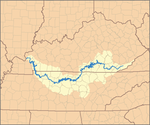
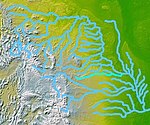
The Missouri River is a river in the Central and Mountain West regions of the United States. The nation's longest, it rises in the eastern Centennial Mountains of the Bitterroot Range of the Rocky Mountains of southwestern Montana, then flows east and south for 2,341 miles (3,767 km) before entering the Mississippi River north of St. Louis, Missouri. The river drains semi-arid watershed of more than 500,000 square miles (1,300,000 km2), which includes parts of ten U.S. states and two Canadian provinces. Although a tributary of the Mississippi, the Missouri River is slightly longer and carries a comparable volume of water. When combined with the lower Mississippi River, it forms the world's fourth-longest river system.
The Tanana River is a 584-mile (940 km) tributary of the Yukon River in the U.S. state of Alaska. According to linguist and anthropologist William Bright, the name is from the Koyukon (Athabaskan) tene no, tenene, literally "trail river".

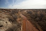
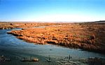
The White River is a Missouri River tributary that flows 580 miles (930 km) through the U.S. states of Nebraska and South Dakota. The name stems from the water's white-gray color, a function of eroded sand, clay, and volcanic ash carried by the river from its source near the Badlands. Draining a basin of about 10,200 square miles (26,000 km2), about 8,500 square miles (22,000 km2) of which is in South Dakota, the stream flows through a region of sparsely populated hills, plateaus, and badlands.

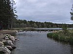
The Spokane River is a tributary of the Columbia River, approximately 111 miles (179 km) long, in northern Idaho and eastern Washington in the United States. It drains a low mountainous area east of the Columbia, passing through the Spokane Valley and the city of Spokane, Washington.

The Kuskokwim River or Kusko River is a river, 702 miles (1,130 km) long, in Southwest Alaska in the United States. It is the ninth largest river in the United States by average discharge volume at its mouth and seventeenth largest by basin drainage area. The Kuskokwim River is the longest river system contained entirely within a single U.S. state.

The Koyukuk River is a 425-mile (684 km) tributary of the Yukon River, in the U.S. state of Alaska. It is the last major tributary entering the Yukon before the larger river empties into the Bering Sea.

The Williamson River of south-central Oregon in the United States is about 100 miles (160 km) long. It drains about 3,000 square miles (7,800 km2) east of the Cascade Range. Together with its principal tributary, the Sprague River, it provides over half the inflow to Upper Klamath Lake, the largest freshwater lake in Oregon. The lake's outlet is the Link River, which flows into Lake Ewauna and the Klamath River.

The Porcupine River is a 916 km (569 mi) tributary of the Yukon River in Canada and the United States. It rises in the Ogilvie Mountains north of Dawson City, Yukon, Canada. From there it flows north through the community of Old Crow, veers southwest into the U.S. state of Alaska, and enters the larger river at Fort Yukon, Alaska. It derives its name from the Gwich'in word for the river, Ch'oonjik, or "Porcupine Quill River".

The Ogeechee River is a 294-mile-long (473 km) blackwater river in the U.S. state of Georgia. It heads at the confluence of its North and South Forks, about 2.5 miles (4.0 km) south-southwest of Crawfordville and flowing generally southeast to Ossabaw Sound about 16 miles (26 km) south of Savannah. Its largest tributary is the Canoochee River, which drains approximately 1,400 square miles (3,600 km2) and is the only other major river in the basin. The Ogeechee has a watershed of 5,540 square miles (14,300 km2). It is one of the state's few free-flowing streams.

The Van Duzen River is a river on the north coast of California. It is a major tributary of the Eel River and drains 429 square miles (1,110 km2), mostly in Humboldt County, with a small portion in Trinity County. The river travels 63 miles (101 km) from its headwaters on the west side of the North Coast Range to its confluence with the Eel River, about 14 miles (23 km) upstream from the Pacific Ocean and 17 miles (27 km) south of Eureka, California. The river's elevation is over 5,000 feet (1,500 m) at its source and only 60 feet (18 m) when it merges with the Eel River. The river has two forks in its upper reaches. The North Fork travels northwest until it reaches the small town of Dinsmore, where it starts flowing west. The Little Van Duzen, which also flows northwest, joins the North Fork a few miles later. The river flows roughly west from then on. It meets its largest tributary, Yaeger Creek, about 5 miles (8.0 km) before it reaches the Eel River.
The Kuparuk River is a river in Alaska's North Slope that enters a bay on the Beaufort Sea between Beechey Point and Prudhoe Bay. The north-flowing river is about 200 miles (320 km) long, and its delta is about 3 miles (5 km) wide. Its Eskimo name appeared on a map drawn in 1901 by a prospector who spelled it Koopowra, which he translated as Big River. Kuukpaaġruk can be translated to a "smaller version of a big river".

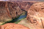
The Bill Williams River is a 46.3-mile-long (74.5 km) river in west-central Arizona where it, along with one of its tributaries, the Santa Maria River, form the boundary between Mohave County to the north and La Paz County to the south. It is a major drainage westwards into the Colorado River of the Lower Colorado River Valley south of Hoover Dam and Lake Mead, and the drainage basin covers portions of northwest, and west-central Arizona. The equivalent drainage system paralleling the east–west lower reaches of the Bill Williams is the Gila River, which flows east-to-west across central Arizona, joining the Colorado River in the southwest at Yuma. The confluence of the Bill Williams River with the Colorado is north of Parker, and south of Lake Havasu City.

The Black River is a 114-mile-long (183 km) river in the White Mountains of the U.S. state of Arizona. It forms south of the town of Greer and west of the towns of Nutrioso and Alpine. The river flows southwest then northwest to meet the White River west of Fort Apache. The merged streams form the Salt River, a major tributary of the Gila River. Both the Salt and Gila rivers supply water to the Phoenix metro area as well as provides water for farmland and crops around the valley.
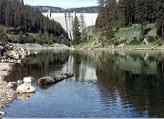
The North Fork Clearwater River is a major tributary of the Clearwater River in the U.S. state of Idaho. From its headwaters in the Bitterroot Mountains of eastern Idaho, it flows 135 miles (217 km) westward and is dammed by the Dworshak Dam just above its mouth in north-central Idaho. Draining a rugged watershed of 2,462 square miles (6,380 km2), the river has an average flow of over 5,600 cubic feet per second (160 m3/s), accounting for a third of the discharge from the Clearwater basin. The river drains parts of Clearwater, Shoshone, Latah, and Idaho counties. Most of the watershed is managed by the U.S. Forest Service. Some of the fish of the river include westslope cutthroat trout, rainbow trout, mountain whitefish, and the threatened bull trout. It also has smallmouth bass and a kokanee salmon run, both from Dworshak Reservoir. The North Fork drainage is home to grizzly bears, cougars, deer, moose, black bear, elk, grey wolves, and osprey. The river used to have a large steelhead run before the implementation of Dworshak Dam. The North Fork of the Clearwater is located within the Clearwater National Forest

Bush River is a tidal estuary in Harford County, Maryland, located about 15 mi (24 km) northeast of Baltimore. The estuary extends from the community of Riverside, south for about 9 mi (14 km), to the Chesapeake Bay. The watershed area of tidal Bush River is 125 mi2 (320 km2), and includes Aberdeen Proving Ground, a military facility.

The South Fork Bull Run River is a tributary, about 6 miles (9.7 km) long, of the Bull Run River in the U.S. state of Oregon. Part of the system that provides drinking water to the city of Portland, it flows generally west through a protected part of the Mount Hood National Forest in Clackamas County. It joins the Bull Run River at Bull Run Reservoir 2, about 8 miles (13 km) from the larger stream's confluence with the Sandy River.