Salaberry-de-Valleyfield

Last updated

Salaberry-de-Valleyfield
Salaberry-de-Valleyfield QC 1.JPG
Skyline of downtown Valleyfield
Blason ville ca Salaberry-de-Valleyfield (Quebec).svg
Logo valleyfield.gif
Nickname: 
The Venice of Quebec
Motto: 
Ubi lux ibi labor
Salaberry-de-Valleyfield Quebec location diagram.PNG
Location within Beauharnois-Salaberry RCM
Canada Southern Quebec location map.png
Red pog.svg
Salaberry-de-Valleyfield
Location in southern Quebec
Coordinates: 45°15′N74°08′W / 45.25°N 74.13°W / 45.25; -74.13 [1]
Country Canada
Province Quebec
Region Montérégie
RCM Beauharnois-Salaberry
Founded1874
ConstitutedApril 24, 2002
Named for Charles-Michel d'Irumberry de Salaberry
Boroughs
List of boroughs
  • Grande-Île
  • Nitro
  • Georges-Leduc
  • Champlain
  • La Baie
  • Robert-Cauchon
  • Jules-Léger
  • Saint-Timothée
Government
  Type Mayor-council government
  MayorMiguel Lemieux
   Federal riding Salaberry—Suroît
   Prov. riding Beauharnois
Area
  Total126.99 km2 (49.03 sq mi)
  Land108.56 km2 (41.92 sq mi)
  Urban
33.93 km2 (13.10 sq mi)
Population
 (2021) [4] [5]
  Total42,787
  Density394.1/km2 (1,021/sq mi)
   Urban
41,655
  Urban density1,227.6/km2 (3,179/sq mi)
  Pop 2016-2021
Increase2.svg 5.0%
  Dwellings
20,962
Demonym(s) Campivallensien, Campivallensienne (fr) Campivallensian (en)
Time zone UTC−5 (EST)
  Summer (DST) UTC−4 (EDT)
Postal code(s)
Area code(s) 450 and 579
Highways
Quebec Autoroute 30.svg A-30
Quebec Autoroute 530.svg A-530

Qc132.svg R-132
Qc201.svg R-201
Website www.ville.valleyfield.qc.ca OOjs UI icon edit-ltr-progressive.svg

Salaberry-de-Valleyfield is a city in southwestern Quebec, Canada, in the Regional County Municipality of Beauharnois-Salaberry. The population as of 2021 was 42,410. [4]

Contents

The historic downtown is a major touristic centre for the area.

Due to the presence of Lake St. Francis on the St. Lawrence River, St. Francis Bay in downtown, and of numerous rivers and canals all over the town, the city is nicknamed "The Venice of Quebec".[ citation needed ]

History

The actual city was founded in 1874, the first mayor was Moise Plante. The first settlers arrived in 1798. At that moment, the settlement was named Pointe-du-Lac (Lake Point). The colony was then renamed Saranac, then Sainte-Cécile. Salaberry-de-Valleyfield was officially named in 1874 after Colonel Charles de Salaberry who served with the British army during the War of 1812. "Valleyfield" came from the Valleyfield Mills, a paper mill south of Edinburgh in Scotland.

The city is the seat of the Roman Catholic Diocese of Valleyfield, founded in 1892.

Salaberry-de-Valleyfield is also the seat of the judicial district of Beauharnois since 1901. [6]

Merger

In 2002, the city of 26,170 amalgamated with the following communities [7] (2001 Canada census figures):

Geography

Situated on Grande-Île, an island in the Saint Lawrence River, it is bordered at its western end by Lake Saint Francis, with the Saint Lawrence to the north and the Beauharnois Canal to its south. The Port of Valleyfield is on the canal.

Climate

Salaberry-de-Valleyfield has a humid continental climate (Dfb) with warm summers and long, cold, and snowy winters.

Climate data for Salaberry-de-Valleyfield
MonthJanFebMarAprMayJunJulAugSepOctNovDecYear
Record high °C (°F)14.0
(57.2)
16.0
(60.8)
23.0
(73.4)
30.0
(86.0)
35.0
(95.0)
34.4
(93.9)
35.6
(96.1)
36.5
(97.7)
35.0
(95.0)
28.9
(84.0)
22.5
(72.5)
17.0
(62.6)
36.5
(97.7)
Average high °C (°F)−5.4
(22.3)
−3.3
(26.1)
2.3
(36.1)
11.2
(52.2)
18.7
(65.7)
23.8
(74.8)
26.1
(79.0)
25.3
(77.5)
20.6
(69.1)
12.8
(55.0)
5.8
(42.4)
−1.4
(29.5)
11.4
(52.5)
Daily mean °C (°F)−9.6
(14.7)
−7.8
(18.0)
−2.2
(28.0)
6.3
(43.3)
13.3
(55.9)
18.7
(65.7)
21.1
(70.0)
20.2
(68.4)
15.6
(60.1)
8.6
(47.5)
2.2
(36.0)
−5.1
(22.8)
6.8
(44.2)
Average low °C (°F)−13.8
(7.2)
−12.3
(9.9)
−6.7
(19.9)
1.3
(34.3)
7.9
(46.2)
13.5
(56.3)
16.0
(60.8)
15.1
(59.2)
10.6
(51.1)
4.3
(39.7)
−1.4
(29.5)
−8.8
(16.2)
2.1
(35.8)
Record low °C (°F)−38.3
(−36.9)
−33.5
(−28.3)
−29
(−20)
−15.6
(3.9)
−4.4
(24.1)
2.2
(36.0)
6.5
(43.7)
1.7
(35.1)
−2.0
(28.4)
−8.9
(16.0)
−21.0
(−5.8)
−32.0
(−25.6)
−38.3
(−36.9)
Average precipitation mm (inches)74.8
(2.94)
59.3
(2.33)
61.9
(2.44)
77.3
(3.04)
82.9
(3.26)
94.7
(3.73)
97.6
(3.84)
92.5
(3.64)
82.6
(3.25)
92.0
(3.62)
85.7
(3.37)
76.8
(3.02)
978.0
(38.50)
Average rainfall mm (inches)24.2
(0.95)
19.9
(0.78)
31.9
(1.26)
70.3
(2.77)
82.9
(3.26)
97.4
(3.83)
97.6
(3.84)
92.5
(3.64)
82.6
(3.25)
90.6
(3.57)
74.4
(2.93)
33.1
(1.30)
794.7
(31.29)
Average snowfall cm (inches)50.6
(19.9)
39.3
(15.5)
30.1
(11.9)
7.2
(2.8)
0.0
(0.0)
0.0
(0.0)
0.0
(0.0)
0.0
(0.0)
0.0
(0.0)
1.3
(0.5)
11.3
(4.4)
43.7
(17.2)
183.5
(72.2)
Source: Environment Canada [8]

Demographics

Historical Census Data - Salaberry-de-Valleyfield, Quebec
YearPop.±%
1921 9,215    
1931 11,411+23.8%
1941 17,052+49.4%
1951 22,414+31.4%
1956 23,584+5.2%
1961 27,297+15.7%
YearPop.±%
1966 29,111+6.6%
1971 30,173+3.6%
1976 29,716−1.5%
1981 29,574−0.5%
1986 27,875−5.7%
1991 27,598−1.0%
YearPop.±%
1996 26,600−3.6%
2001 26,170−1.6%
2006 39,672+51.6%
2011 40,077+1.0%
2016 40,745+1.7%
2021 42,787+5.0%
Amalgamated with Saint-Timothée and Grande-Île in 2002.
Source: Statistics Canada [9]

In the 2021 Census of Population conducted by Statistics Canada, Salaberry-de-Valleyfield had a population of 42,787 living in 20,073 of its 20,962 total private dwellings, a change of 5% from its 2016 population of 40,745. With a land area of 108.56 km2 (41.92 sq mi), it had a population density of 394.1/km2 (1,020.8/sq mi) in 2021. [4]

Canada census – Salaberry-de-Valleyfield community profile
2021 2016 2011
Population42,787 (+5.0% from 2016)40,745 (+1.7% from 2011)40,077 (+1.0% from 2006)
Land area108.56 km2 (41.92 sq mi)107.13 km2 (41.36 sq mi)107.10 km2 (41.35 sq mi)
Population density394.1/km2 (1,021/sq mi)380.3/km2 (985/sq mi)374.2/km2 (969/sq mi)
Median age47.2 (M: 45.2, F: 49.6)48.3 (M: 46.0, F: 50.1)47.1 (M: 45.1, F: 48.7)
Total private dwellings20,96219,35619,050
Median household income$62,000$50,952$44,510
Notes: Amalgamated with Saint-Timothée and Grande-Île in 2002.
References: 2021 [10] 2016 [11] 2011 [12] earlier [13] [14]
Canada Census Mother Tongue - Salaberry-de-Valleyfield, Quebec [9]
Amalgamated with Saint-Timothée and Grande-Île in 2002.
CensusTotal
French
English
French & English
Other
YearResponsesCountTrendPop %CountTrendPop %CountTrendPop %CountTrendPop %
2016
39,670
37,480Increase2.svg 0.01%94.48%1,160Increase2.svg 5.0%2.92%395Decrease2.svg 13.2%1.00%570Increase2.svg 46.2%1.44%
2011
39,425
37,475Increase2.svg 1.7%95.05%1,105Increase2.svg 6.8%2.80%455Increase2.svg 89.6%1.15%390Decrease2.svg 12.4%0.99%
2006
38,565
36,845Increase2.svg 51.9%95.54%1,035Increase2.svg 40.8%2.68%240Increase2.svg 20.0%0.62%445Increase2.svg 74.5%1.15%
2001
25,450
24,260Decrease2.svg 2.4%95.32%735Increase2.svg 11.4%2.89%200Decrease2.svg 14.9%0.79%255Increase2.svg 4.1%1.00%
1996
25,995
24,855n/a95.61%660n/a2.54%235n/a0.90%245n/a0.94%

Government

Nicholson Street with city hall in the centre Salaberry-de-Valleyfield QC 2.JPG
Nicholson Street with city hall in the centre

The city council is composed of the mayor and eight city councillors. The municipal elections are at each 4 years, each councillor stands for his/her district.

City Council [15]
Function/District2005-20092009-20132013-20172017-2021
MayorDenis LapointeDenis LapointeDenis LapointeMiguel Lemieux
1 - Grande-ÎleDenis LaîtreDenis LaîtreDenis LaîtreLyne Lefebvre
2 - NitroJean-Marc RochonJean-Marc RochonJean-Marc RochonJason Grenier
3 - Georges-LeducClaude ReidLouise SauvéLouise SauvéJean-Marc Rochon
4 - ChamplainRobert SavardRobert SavardJean-Luc PomerleauFrance Chenail
5 - La BaieRoger LevertJean-Jacques LeducFrançois LabossièreGuillaume Massicotte
6 - Robert-CauchonJacques SmithJacques SmithJacques SmithJacques Smith
7 - Jules-LégerPierre-Paul MessierPierre-Paul MessierPatrick RancourtPatrick Rancourt
8 - Saint-TimothéeNormand AmesseNormand AmesseNormand AmesseNormand Amesse

List of former mayors: [16]

Attractions

The Musée de Société des Deux-Rives (MUSO), which covers the economic and cultural history of the region, is located in the city.

The city houses one of the 10 minor basilicas in Quebec. Cathedral-Basilica of Saint Cecilia, built in 1934–1935, is one of the largest churches in the country.

The city has been the site of the Valleyfield Regattas since 1938. The event takes place every year at the beginning of July over a three-day period in the heart of the city on Bay Saint-François. It is an international hydroplane competition, in which power boats achieve speeds of up to 225 km/h. Attracting over 130,000 visitors per year, it also includes other cultural activities. [17]

Education

Gault Institute

The Gault Institute was created by Andrew Frederick Gault. He created this school during the time that the Gault Cotton Mills were up and running. To heat the school at one time he used underground pipes connecting from the school to the Cotton Mills since at the time there was no electricity.

Notable people

See also

Related Research Articles

<span class="mw-page-title-main">Terrebonne, Quebec</span> City in Quebec, Canada

Terrebonne is an off-island suburb of Montreal, in southwestern Quebec, Canada. It is located in the North Shore region of the Montreal area, north of Laval across the Rivière des Mille-Îles.

<span class="mw-page-title-main">Beauharnois-Salaberry Regional County Municipality</span> Regional county municipality in Quebec, Canada

Beauharnois-Salaberry is a regional county municipality in the Montérégie region of Quebec, Canada. Its seat is Beauharnois.
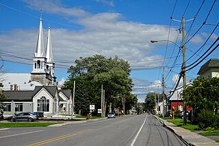
<span class="mw-page-title-main">Beauharnois—Salaberry</span> Federal electoral district in Quebec, Canada

Beauharnois—Salaberry is a former federal electoral district in Quebec, Canada, that was represented in the House of Commons of Canada from 1949 to 2015.

Beauharnois was a federal electoral district in Quebec, Canada, that was represented in the House of Commons of Canada from 1867 to 1935, from 1949 to 1953, and from 1968 to 1972.

<span class="mw-page-title-main">Beauharnois Canal</span>

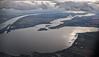
The Beauharnois Canal is located in southwestern Quebec, Canada. The canal is part of the Saint Lawrence Seaway.

<span class="mw-page-title-main">Grande-Île, Quebec</span> Former municipality in Quebec, Canada

Grande-Île is an island in the St. Lawrence River in Quebec, Canada. The island is mostly occupied by the city Salaberry-de-Valleyfield. Part of the Hochelaga Archipelago, the island connects the Beauharnois-Salaberry and the Vaudreuil-Soulanges regions over the Saint Lawrence River via the Pont Monseigneur Langlois. Grande-Île was also the name of a municipality on the island which merged with Salaberry-de-Valleyfield on January 1, 2002.

<span class="mw-page-title-main">Beauharnois, Quebec</span> City in Quebec, Canada

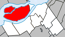
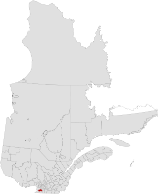
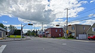
Beauharnois is a city located in the Beauharnois-Salaberry Regional County Municipality of southwestern Quebec, Canada, and is part of the Greater Montreal Area. The city's population as of the Canada 2011 Census was 12,011. It is home to the Beauharnois Hydroelectric Power Station, as well as the Beauharnois Lock of the Saint Lawrence Seaway.

<span class="mw-page-title-main">Sainte-Martine, Quebec</span> Municipality in Quebec, Canada

Sainte-Martine is a municipality in Beauharnois-Salaberry Regional County Municipality in the Montérégie region of Quebec, Canada. The population as of the Canada 2016 Census was 5,461. The municipality is made up of a large northern section and a small unattached southern area that was known as the municipality of Saint-Paul-de-Châteauguay until its merger with Sainte-Martine on September 9, 1999.

<span class="mw-page-title-main">Les Coteaux, Quebec</span> Municipality in Quebec, Canada

Les Coteaux is a municipality in Vaudreuil-Soulanges Regional County Municipality in the Montérégie region of Quebec, Canada. It is located north of the Saint Lawrence River and Salaberry-de-Valleyfield.

Saint-Timothée is a former municipality located in the Montérégie region of Quebec, Canada, on Île-de-Salaberry in the St. Lawrence River. It occupied the middle third and largest area of the island, which is part of the Hochelaga Archipelago. The municipality is flanked by the cities of Beauharnois to the east, and to the west by Salaberry-de-Valleyfield, which Saint-Timothée was merged with on January 1, 2002.

<span class="mw-page-title-main">Dundee, Quebec</span> Township municipality in Quebec, Canada

Dundee is a township municipality in Le Haut-Saint-Laurent Regional County Municipality in the Montérégie administrative region of Quebec, Canada. At the Canada 2021 Census, the population was 386. It is primarily an agricultural area consisting of dairy and grain farms.

<span class="mw-page-title-main">Pointe-des-Cascades, Quebec</span> Village municipality in Quebec, Canada

Pointe-des-Cascades is a village municipality in Vaudreuil-Soulanges Regional County Municipality in the Montérégie region of Quebec, Canada. It is located on a spit of land where the St. Lawrence River flows into Lake Saint-Louis. The river has here a significant drop, forming several cascades which give the village its name. The islands of Île des Cascades and Île des Joybert are connected by a narrow causeway, but Île des Cascades and Pointe-des-Cascades are only connected artificially.

<span class="mw-page-title-main">Saint-Urbain-Premier, Quebec</span> Municipality in Quebec, Canada

Saint-Urbain-Premier is a municipality located southwest of Montreal in Beauharnois-Salaberry, in the Montérégie region of Quebec, Canada. The population as of the Canada 2016 Census was 1,264. The municipality is named for Pope Urban I, who reigned from 222 to 230AD.

<span class="mw-page-title-main">Saint-Édouard, Quebec</span> Municipality in Quebec, Canada

Saint-Édouard is a municipality in the Jardins de Napierville Regional County Municipality in Quebec, Canada, situated in the Montérégie administrative region. The population as of the Canada 2016 census was 1,321.

<span class="mw-page-title-main">Saint-Jacques-le-Mineur, Quebec</span> Municipality in Quebec, Canada

Saint-Jacques-le-Mineur is a municipality in the Jardins de Napierville Regional County Municipality in Quebec, Canada, situated in the Montérégie administrative region. The population as of the Canada 2011 Census was 1,672.

<span class="mw-page-title-main">Saint-Mathieu, Quebec</span> Municipality in Quebec, Canada

Saint-Mathieu is a municipality situated in the Montérégie administrative region in Quebec, Canada. The population as of the Canada 2016 Census was 2,156. It is part of the Roussillon Regional County Municipality.

<span class="mw-page-title-main">Saint-Stanislas-de-Kostka</span> Municipality in Quebec, Canada

Saint-Stanislas-de-Kostka is a municipality of Quebec, Canada, located within the Beauharnois-Salaberry Regional County Municipality in the Montérégie administrative region. The population as of the Canada 2021 Census was 1,852.

<span class="mw-page-title-main">Saint-Louis-de-Gonzague, Montérégie, Quebec</span> Parish municipality in Quebec, Canada

Saint-Louis-de-Gonzague is a parish municipality in the Beauharnois-Salaberry Regional County Municipality in the Montérégie region of Quebec, Canada. The population as of the Canada 2021 Census was 1,950.

<span class="mw-page-title-main">Saint-Étienne-de-Beauharnois, Quebec</span> Municipality in Quebec, Canada

Saint-Étienne-de-Beauharnois is a municipality of Quebec, Canada, located within the Beauharnois-Salaberry Regional County Municipality in the Montérégie administrative region. The population as of the Canada 2021 Census was 1,099.

<span class="mw-page-title-main">Saint Charles River (Valleyfield)</span> River in Quebec, Canada

The Saint Charles River is a branch of the Saint Lawrence River that starts in Salaberry-de-Valleyfield, Quebec, Canada. The river divides the Grande-Île and the Island of Salaberry, which are located approximately 50 km east of Montreal. The river is 8 km long, and drops 24m over its course from Lake Saint Francis east to Lake Saint-Louis.

References

  1. "Reference number 125037 in Banque de noms de lieux du Québec". toponymie.gouv.qc.ca (in French). Commission de toponymie du Québec.
  2. 1 2 "Répertoire des municipalités: Salaberry-de-Valleyfield". www.mamh.gouv.qc.ca. Ministère des Affaires municipales et de l'Habitation. Retrieved 2023-09-13.
  3. Riding history for Beauharnois—Salaberry, Quebec from the Library of Parliament
  4. 1 2 3 4 "Salaberry-de-Valleyfield, Ville (V) Census Profile, 2021 Census of Population". www12.statcan.gc.ca. Government of Canada - Statistics Canada. Retrieved 13 September 2023.
  5. 1 2 "Salaberry-de-Valleyfield Quebec [Population centre], Census Profile, 2021 Census of Population". www12.statcan.gc.ca. Government of Canada - Statistics Canada. Retrieved 13 September 2023.
  6. Territorial Division Act. Revised Statutes of Quebec D-11.
  7. "Archived copy" (PDF). stat.gouv.qc.ca. Archived from the original (PDF) on 30 December 2006. Retrieved 22 May 2022.{{cite web}}: CS1 maint: archived copy as title (link)
  8. "Salaberry-de-Valleyfield Climate". Canadian Climate Normals 1981–2010 (in English and French). Environment Canada. 31 October 2011. Retrieved June 6, 2015.
  9. 1 2 Statistics Canada: 1996, 2001, 2006, 2011 census
  10. "2021 Community Profiles". 2021 Canadian Census . Statistics Canada. February 4, 2022. Retrieved 2022-04-27.
  11. "2016 Community Profiles". 2016 Canadian Census . Statistics Canada. August 12, 2021. Retrieved 2023-09-13.
  12. "2011 Community Profiles". 2011 Canadian Census . Statistics Canada. March 21, 2019. Retrieved 2014-01-28.
  13. "2006 Community Profiles". 2006 Canadian Census . Statistics Canada. August 20, 2019.
  14. "2001 Community Profiles". 2001 Canadian Census . Statistics Canada. July 18, 2021.
  15. Tremblay, Éric (November 6, 2017). "Miguel Lemieux succède à Denis Lapointe (French Only)". Journal Saint-François.
  16. "Répertoire des entités géopolitiques: Salaberry-de-Valleyfield (ville) 1.1.1875 - ..." www.mairesduquebec.com. Institut généalogique Drouin. Retrieved 13 September 2023.
  17. Home - Régates de Valleyfield
  18. Calvé, Mélanie (September 5, 2019). "Karla Homolka Vit Maintenant a Salaberry de Valleyfield". Viva Media. Retrieved September 5, 2019.