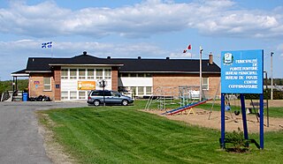
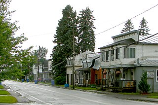
Pointe-Fortune is a municipality in southwestern Quebec, Canada, on the Ottawa River in Vaudreuil-Soulanges Regional County Municipality, northwest of Montreal. The population at the 2021 Census was 582.

Rigaud is a city in southwestern Quebec, Canada, in the Vaudreuil-Soulanges Regional County Municipality in Vallée-du-Haut-Saint-Laurent region. It is located at the junction of the Ottawa River and the Rigaud River, about 70 kilometres (43 mi) west of downtown Montreal and 130 kilometres (81 mi) east of Ottawa. The population as of the Canada 2021 Census was 7,854.
Vaudreuil-Dorion is a suburb of Greater Montreal, in the Montérégie region of southwestern Quebec, Canada. The result of the merger of two towns, Vaudreuil and Dorion, it is located in the Vaudreuil-Soulanges Regional County Municipality.

Hudson is an off-island suburb of Montreal, with a population of 5,411. It is located on the south-west bank of the lower Ottawa River, in Vaudreuil-Soulanges Regional County Municipality. Situated about 60 kilometres (37 mi) west of downtown Montreal, many residents commute to work on the Island of Montreal.

Saint-Télesphore is a municipality located in Vaudreuil-Soulanges Regional County Municipality, Quebec (Canada). The population as of the 2021 Canadian census was 754. The municipality is situated west of Saint-Polycarpe, south of Sainte-Justine-de-Newton, north of Rivière-Baudette and east of the provincial border near North Lancaster, Ontario.
Saint-Chrysostome is a municipality in south-west Quebec, Canada in the regional county municipality of Haut-Saint-Laurent in the Montérégie administrative region. The municipality was created by the amalgamation of Saint-Chrysostome village with the parish of Saint-Jean-Chrysostome on September 29, 1999. The population as of the 2021 Canadian census was 2,582.

Nominingue is a small village and municipality located 200 kilometres (120 mi) north of Montreal, Quebec, Canada, in the Laurentian Mountains. It was formerly called Lac-Nominingue, but changed name on September 16, 2000.

Saint-Zotique is a city located within the Vaudreuil-Soulanges Regional County Municipality in the Montérégie region located about 45 minutes west of Montreal, Quebec, Canada. It is named for Saint Zoticus of Comana.

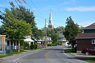
Saint-Polycarpe is a municipality located in the Vaudreuil-Soulanges Regional County Municipality in the Montérégie region west of Montreal, Quebec, Canada, and just east of the Quebec-Ontario border. It was named for Polycarp, a 2nd-century bishop of Smyrna. The population as of the 2021 Canadian Census was 2,372.
Très-Saint-Rédempteur is a municipality located in the Montérégie region of Quebec, Canada, along the border with Ontario. The population as of the Canada 2021 Census was 978. The municipality includes the town of Saint-Redempteur, and lies south of Rigaud along Route 325.
Sainte-Justine-de-Newton is a municipality located in the Montérégie region of Quebec, Canada. The population as of the 2021 Canadian census was 947. The municipality is situated on Route 325 south of Très-Saint-Rédempteur, just east of the Ontario border.
Saint-Clet is a municipality located in the Vaudreuil-Soulanges Regional County Municipality within the Montérégie region of Quebec, Canada. The population as of the 2021 Canadian census was 1,700. Completely surrounded by agricultural land, the town is centred on the intersection of two main provincial highways. The north–south Route 201 is known as rue Principale within the town limits, and the east–west Route 340 is known as Boulevard de la Cité des Jeunes.

Les Coteaux is a municipality in Vaudreuil-Soulanges Regional County Municipality in the Montérégie region of Quebec, Canada. It is located north of the Saint Lawrence River and Salaberry-de-Valleyfield.
Les Cèdres is a municipality located north of the Saint Lawrence River in the Montérégie of Quebec, Canada, near Vaudreuil-Dorion. The population as of the Canada 2021 Census was 7,184. The name means "The Cedars" in French.

Rivière-Beaudette is a municipality of Quebec, Canada, located in the southwest corner of the Vaudreuil-Soulanges Regional County Municipality on the border with Ontario along the St. Lawrence River. The population as of the 2021 Canadian census was 2,489.

Sainte-Marthe is a municipality located in the Vaudreuil-Soulanges Regional County Municipality of Quebec, Canada. The population as of the 2021 Canadian census was 1,014.

Pointe-des-Cascades is a village municipality in Vaudreuil-Soulanges Regional County Municipality in the Montérégie region of Quebec, Canada. It is located on a spit of land where the St. Lawrence River flows into Lake Saint-Louis. The river has here a significant drop, forming several cascades which give the village its name. The islands of Île des Cascades and Île des Joybert are connected by a narrow causeway, but Île des Cascades and Pointe-des-Cascades are only connected artificially.
Vaudreuil-sur-le-Lac is a village municipality in Vaudreuil-Soulanges Regional County Municipality in the Montérégie region of Quebec, Canada. It is located on the western portion of the Vaudreuil Peninsula, which projects into Lake of Two Mountains. The population as of the Canada 2016 Census was 1,341.

L'Île-Cadieux is a village and municipality in the Montérégie region of Quebec, Canada, part of the Vaudreuil-Soulanges Regional County Municipality. It is located on and contiguous with Cadieux Island, which projects into Lake of Two Mountains just north off Vaudreuil-sur-le-Lac. The population as of the Canada 2011 Census was 105.
Saint-Louis-de-Gonzague is a parish municipality in the Beauharnois-Salaberry Regional County Municipality in the Montérégie region of Quebec, Canada. The population as of the 2021 Canadian census was 1,950.


