Sainte-Catherine, Quebec

Last updated
Sainte-Catherine
Sainte-Catherine Instal port Bld Hebert.jpg
Saint Lawrence Seaway at Sainte-Catherine
Sainte-Catherine Quebec location diagram.PNG
Location within Roussillon RCM
Canada Southern Quebec location map.png
Red pog.svg
Sainte-Catherine
Location in southern Quebec
Coordinates: 45°24′14″N73°34′13″W / 45.40402°N 73.5704°W / 45.40402; -73.5704 Coordinates: 45°24′14″N73°34′13″W / 45.40402°N 73.5704°W / 45.40402; -73.5704 [1]
CountryFlag of Canada (Pantone).svg  Canada
Province Flag of Quebec.svg  Quebec
Region Montérégie
RCM Roussillon
ConstitutedOctober 30, 1937
Government
  MayorJocelyne Bates
   Federal riding La Prairie
   Prov. riding Sanguinet
Area
  Total16.00 km2 (6.18 sq mi)
  Land9.50 km2 (3.67 sq mi)
Population
 (2011) [4]
  Total16,762
  Density1,764.1/km2 (4,569/sq mi)
  Pop 2006–2011
Increase2.svg 3.4%
  Dwellings
6,652
Time zone UTC−5 (EST)
  Summer (DST) UTC−4 (EDT)
Postal code(s)
J5C
Area code(s) 450 and 579
Highways
Quebec Autoroute 30.svg A-30

Qc132.svg Route 132
Website www.ville.sainte-catherine.qc.ca

Sainte-Catherine is an off-island suburb of Montreal, in southwestern Quebec, Canada, on the St. Lawrence River in the Regional County Municipality of Roussillon. The population as of the Canada 2011 Census was 16,762.

Contents

History

The land had been occupied for more than three centuries, since the establishment of the Iroquois mission in 1676, it is only in 1937 that the founding of la paroisse de Sainte-Catherine de Laprairie really marks a territorial organization. In 1973, a demographic boom finally granted the status of town to the village. In 2006, according to the city's official site, there were 17,000 inhabitants in Sainte-Catherine.

The inauguration of the Honoré Mercier Bridge in 1934, and then of the Champlain Bridge in 1962, greatly boosted the local economy.

Demographics

Canada census – Sainte-Catherine community profile
2021 2011
Population17,347 (+1.8% from 2016)16,762 (+3.4% from 2006)
Land area9.37 km2 (3.62 sq mi)9.50 km2 (3.67 sq mi)
Population density1,851.4/km2 (4,795/sq mi)1,764.1/km2 (4,569/sq mi)
Median age43.6 (M: 42, F: 45.2)39.3 (M: 38.1, F: 40.4)
Total private dwellings6,9056,652
Median household income$68,634
References: 2021 [5] 2011 [4] earlier [6] [7]
Historical Census Data – Sainte-Catherine, Quebec [8]
YearPop.±%
1991 9,805    
1996 13,724+40.0%
2001 15,953+16.2%
2006 16,211+1.6%
2011 16,762+3.4%
Canada Census Mother Tongue – Sainte-Catherine, Quebec [8]
CensusTotal
French
English
French & English
Other
YearResponsesCountTrendPop %CountTrendPop %CountTrendPop %CountTrendPop %
2016
16,980
14,950Decrease2.svg 0.6%88.04%630Decrease2.svg 0.06%3.71%155Increase2.svg 10%0.91%1,100Increase2.svg 34.96%6.47%
2011
16,670
15,040Increase2.svg 0.8%90.22%675Increase2.svg 39.2%4.05%140Increase2.svg 40.0%0.84%815Increase2.svg 61.4%4.89%
2006
16,005
14,915Increase2.svg 1.4%93.19%485Decrease2.svg 28.7%3.03%100Decrease2.svg 4.8%0.62%505Increase2.svg 11.0%3.16%
2001
15,945
14,705Increase2.svg 14.0%92.22%680Increase2.svg 41.7%4.26%105Steady2.svg 0.0%0.66%455Increase2.svg 97.8%2.85%
1996
13,710
12,895n/a94.06%480n/a3.50%105n/a0.76%230n/a1.68%

Famous natives

See also

Related Research Articles

Mirabel, Quebec City in Quebec, Canada

Mirabel is an off-island suburb of Montreal, located in southern Quebec.

Abitibi Regional County Municipality Regional county municipality in Quebec, Canada

Abitibi Regional County Municipality is a regional county municipality in the Abitibi-Témiscamingue region of Quebec. The seat is Amos.

Abitibi-Ouest Regional County Municipality Regional county municipality in Quebec, Canada

Abitibi-Ouest Regional County Municipality is a regional county municipality located in the Abitibi-Témiscamingue region of Quebec. Its seat is La Sarre.

Antoine-Labelle Regional County Municipality Regional county municipality in Quebec, Canada

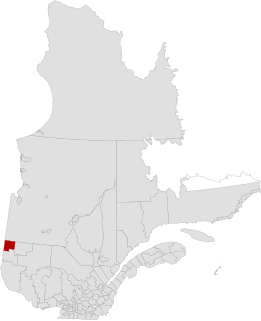
Antoine-Labelle is a regional county municipality located in the Laurentides region of Quebec, Canada. Its seat is Mont-Laurier. It is named for Antoine Labelle.

La Vallée-du-Richelieu Regional County Municipality Regional county municipality in Quebec, Canada

La Vallée-du-Richelieu(The Valley of the Richelieu) is a regional county municipality in the Montérégie region in southwestern Quebec, Canada. Its seat is McMasterville.

LÎle-dOrléans Regional County Municipality Regional county municipality in Quebec, Canada

L'Île-d'Orléans is a regional county municipality in central Quebec, Canada, in the Capitale-Nationale region. Its seat is Sainte-Famille-de-l'Île-d'Orléans. The population in the 2016 census was 7,082 people.

Saint-Constant, Quebec City in Quebec, Canada

Saint-Constant is a city in southwestern Quebec, Canada. It is located on the south shore of Montreal in the Roussillon Regional County Municipality of the Montérégie region. The population as of the Canada 2016 Census was 27,359.

La Prairie, Quebec City in Quebec, Canada

La Prairie is an off-island suburb of Montreal, in southwestern Quebec, Canada, at the confluence of the Saint-Jacques River and the Saint Lawrence River in the Regional County Municipality of Roussillon. The population as of the Canada 2011 Census was 23,357.

Delson City in Quebec, Canada

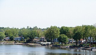
Delson is an off-island suburb of Montreal, Quebec, Canada. It is situated 8 mi/13 km SSE of Montreal within the regional county municipality of Roussillon in the administrative region of Montérégie. The population as of the Canada 2021 Census was 8,328.

LÎle-Perrot, Quebec City in Quebec, Canada

The Town of Île-Perrot is a town and municipality on Île Perrot in southwestern Quebec, Canada. The population as of the Canada 2016 Census was 10,756. The town is at the western end of Lake Saint-Louis, and borders the local island communities of Terrasse-Vaudreuil, Pincourt and Notre-Dame-de-l'Île-Perrot. It also includes Dowker Island and the small Claude and Bellevue Islands.

Dégelis City in Quebec, Canada

Dégelis is a city in Témiscouata Regional County Municipality within the Bas-Saint-Laurent region of Quebec. Its population in the Canada 2011 Census was 3,051. The Madawaska River flows from Lake Témiscouata, through Degelis, to join the Saint John River at 32 kilometres (20 mi) to the East at Edmundston, New Brunswick.

Sainte-Anne-des-Monts City in Quebec, Canada

Sainte-Anne-des-Monts is a city in the Gaspésie–Îles-de-la-Madeleine region of the province of Quebec in Canada.

La Martre, Quebec Municipality in Quebec, Canada

La Martre is a municipality in the Gaspésie-Îles-de-la-Madeleine region of the province of Quebec in Canada.

Sainte-Martine, Quebec Municipality in Quebec, Canada

Sainte-Martine is a municipality in Beauharnois-Salaberry Regional County Municipality in the Montérégie region of Quebec, Canada. The population as of the Canada 2016 Census was 5,461. The municipality is made up of a large northern section and a small unattached southern area that was known as the municipality of Saint-Paul-de-Châteauguay until its merger with Sainte-Martine on September 9, 1999.

Causapscal City in Quebec, Canada

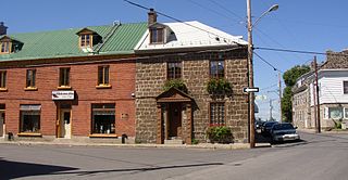
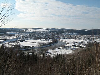
Causapscal is a city in the Canadian province of Quebec, located in La Matapédia Regional County Municipality. It is located at the confluence of the Matapédia and Causapscal Rivers, along Quebec Route 132, approximately halfway between Mont-Joli and Campbellton, New Brunswick. It is served by the Causapscal railway station and the Causapscal Airport.

La Macaza Municipality in Quebec, Canada

La Macaza is a municipality and village in the province of Quebec, Canada. The village is located in the Laurentian Mountains, in the Laurentian region, in Antoine-Labelle Regional County Municipality. Its population was 1094 in the 2021 Canadian census.

Sainte-Barbe, Quebec Municipality in Quebec, Canada

Sainte-Barbe is a municipality of Quebec, located within Le Haut-Saint-Laurent Regional County Municipality in the Montérégie administrative region. The population as of the Canada 2021 Census was 1,609.

Saint-Pierre-de-lÎle-dOrléans Municipality in Quebec, Canada

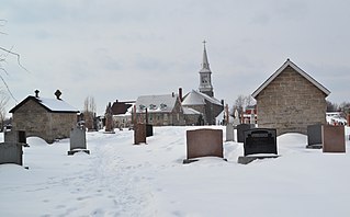
Saint-Pierre-de-l'Île-d'Orléans is a municipality in the Capitale-Nationale region of Quebec, Canada, part of the L'Île-d'Orléans Regional County Municipality. It is situated on the west side of Orléans Island, and accessible by Quebec Route 368 and the Île d'Orléans Bridge which connects Saint-Pierre with the Beauport borough of Quebec City. Until 1997, it was known simply as Saint-Pierre.

Sainte-Geneviève-de-Berthier, Quebec Municipality in Quebec, Canada

Sainte-Geneviève-de-Berthier is a municipality in the Lanaudière region of Quebec, Canada, part of the D'Autray Regional County Municipality. It is crossed by the river La Chaloupe. The Saint-Joseph River also passes over 2.1 km in the southwestern part of the municipal territory.

Matane Town in Quebec, Canada

Matane is a town on the Gaspé Peninsula in Quebec, Canada, on the south shore of the Saint Lawrence River at the mouth of the Matane River. The town is the seat for the La Matanie Regional County Municipality.

References

  1. Reference number 56073 of the Commission de toponymie du Québec (in French)
  2. 1 2 Ministère des Affaires municipales, des Régions et de l'Occupation du territoire: Sainte-Catherine
  3. Riding history for Châteauguay–Saint-Constant, Quebec from the Library of Parliament
  4. 1 2 3 "2011 Community Profiles". 2011 Canadian Census . Statistics Canada. March 21, 2019. Retrieved 2014-02-22.
  5. "2021 Community Profiles". 2021 Canadian Census . Statistics Canada. February 4, 2022. Retrieved 2022-04-27.
  6. "2006 Community Profiles". 2006 Canadian Census . Statistics Canada. August 20, 2019.
  7. "2001 Community Profiles". 2001 Canadian Census . Statistics Canada. July 18, 2021.
  8. 1 2 Statistics Canada: 1996, 2001, 2006, 2011, 2016census