Mirabel, Quebec

Last updated

Mirabel
Ville de Mirabel
Mirabel QC.JPG
Mirabel City Hall
Mirabel Logo.png
Mirabel Quebec location diagram.png
Location with surrounding municipalities
Canada Central Quebec location map.png
Red pog.svg
Mirabel
Location in central Quebec
Coordinates: 45°39′49″N074°00′07″W / 45.66361°N 74.00194°W / 45.66361; -74.00194 [1] [3]
CountryCanada
Province Quebec
Region Laurentides
RCM None
ConstitutedJanuary 1, 1971
Government
[4]
  Mayor Patrick Charbonneau
   Federal riding Mirabel
   Prov. riding Mirabel
Area
  Total486.80 km2 (187.95 sq mi)
  Land484.09 km2 (186.91 sq mi)
Population
 (2021) [5]
  Total61,108
  Density126.2/km2 (327/sq mi)
  Change
2016-2021
Increase2.svg 21%
  Dwellings
25,514
Time zone UTC−5 (EST)
  Summer (DST) UTC−4 (EDT)
Postal code(s)
Area code(s) 450 and 579
Highways
Quebec Autoroute 15.svgTrans-Canada Highway shield.svg A-15 (TCH)
Quebec Autoroute 50.svg A-50
Quebec Autoroute 13.svg A-13

Qc117.svg R-117
Qc148.svg R-148
Qc158.svg R-158
Website ville.mirabel.qc.ca OOjs UI icon edit-ltr-progressive.svg

Mirabel is a suburb of Montreal, located on the North Shore in southern Quebec.

Contents

Mirabel is also the name of a territory equivalent to a regional county municipality (TE) and census division (CD) of Quebec, coextensive with the city of Mirabel. [5] Its geographical code is 74. Prior to 2002, Mirabel was not only a city but also comprised the Mirabel Regional County Municipality.

The city is home to Montréal–Mirabel International Airport.

History

The Belle-Riviere Estate in Sainte-Scholastique, built in 1804 Manoir de Belle-Riviere 4.JPG
The Belle-Rivière Estate in Sainte-Scholastique, built in 1804

Mirabel was formed through the expropriation of private lands and the merger of 8 municipalities in 1971. The former municipalities were (with their individual founding dates in brackets): Saint-Augustin (1855); Saint-Benoît (1855); Saint-Hermas (1855); Saint-Janvier-de-Blainville (1855); Sainte-Scholastique (1855); Saint-Canut (1857); Sainte-Monique (1872), and Saint-Janvier-de-la-Croix (1959). Initially called Ville de Sainte-Scholastique but renamed Mirabel in 1973, the city was planned to become a vast transportation and industrial hub for Eastern Canada, with Montréal–Mirabel International Airport at its centre. [6]

Montréal–Mirabel International Airport, which opened in 1975, never became a major aviation hub and the industrial parks never materialized, and in 2004, the airport closed to all scheduled commercial passenger traffic. It continues to operate as a cargo airport and handles a few charter passenger flights.

In 2000, about 10 km2 (3.9 sq mi) of Mirabel's territory was annexed by Lachute.

Geography

Communities

Climate

Climate data for Mirabel (Montréal–Mirabel International Airport)
Climate ID: 6153300; coordinates 45°40′N74°02′W / 45.667°N 74.033°W / 45.667; -74.033 (Calgary International Airport) ; elevation: 82.6 m (271 ft); 1981-2010 normals
MonthJanFebMarAprMayJunJulAugSepOctNovDecYear
Record high humidex 12.512.321.734.239.445.545.545.440.232.722.918.645.5
Record high °C (°F)12.0
(53.6)
12.6
(54.7)
21.8
(71.2)
31.1
(88.0)
31.4
(88.5)
33.5
(92.3)
33.6
(92.5)
36.1
(97.0)
33.3
(91.9)
26.7
(80.1)
19.8
(67.6)
16.4
(61.5)
36.1
(97.0)
Mean daily maximum °C (°F)−6.5
(20.3)
−4.3
(24.3)
1.3
(34.3)
10.8
(51.4)
18.5
(65.3)
23.4
(74.1)
25.7
(78.3)
24.7
(76.5)
19.9
(67.8)
12.5
(54.5)
4.7
(40.5)
−2.7
(27.1)
10.7
(51.3)
Daily mean °C (°F)−11.5
(11.3)
−9.5
(14.9)
−3.6
(25.5)
5.4
(41.7)
12.4
(54.3)
17.4
(63.3)
19.8
(67.6)
18.7
(65.7)
14.1
(57.4)
7.3
(45.1)
0.6
(33.1)
−7.1
(19.2)
5.3
(41.5)
Mean daily minimum °C (°F)−16.5
(2.3)
−14.8
(5.4)
−8.5
(16.7)
0.0
(32.0)
6.3
(43.3)
11.4
(52.5)
14.0
(57.2)
12.7
(54.9)
8.1
(46.6)
2.0
(35.6)
−3.4
(25.9)
−11.5
(11.3)
0.0
(32.0)
Record low °C (°F)−37.0
(−34.6)
−33.1
(−27.6)
−29.9
(−21.8)
−15.4
(4.3)
−3.9
(25.0)
−0.9
(30.4)
4.8
(40.6)
1.1
(34.0)
−5.3
(22.5)
−8.0
(17.6)
−22.1
(−7.8)
−33.0
(−27.4)
−37.0
(−34.6)
Record low wind chill −50.0−44.0−40.0−24.0−10.0−3.00.00.0−7.0−12.0−28.0−46.0−50.0
Average precipitation mm (inches)87.9
(3.46)
64.6
(2.54)
70.4
(2.77)
88.0
(3.46)
86.8
(3.42)
103.1
(4.06)
91.9
(3.62)
96.0
(3.78)
91.7
(3.61)
96.5
(3.80)
103.2
(4.06)
87.6
(3.45)
1,067.7
(42.04)
Average rainfall mm (inches)32.0
(1.26)
21.8
(0.86)
30.7
(1.21)
72.9
(2.87)
86.5
(3.41)
103.1
(4.06)
91.9
(3.62)
95.9
(3.78)
91.7
(3.61)
93.1
(3.67)
80.4
(3.17)
36.0
(1.42)
835.9
(32.91)
Average snowfall cm (inches)55.8
(22.0)
43.1
(17.0)
38.5
(15.2)
14.0
(5.5)
0.3
(0.1)
0.0
(0.0)
0.0
(0.0)
0.0
(0.0)
0.0
(0.0)
3.1
(1.2)
22.8
(9.0)
51.3
(20.2)
228.8
(90.1)
Average precipitation days (≥ 0.2 mm)16.814.013.813.013.713.212.712.011.413.816.117.1167.5
Average rainy days (≥ 0.2 mm)4.43.96.411.213.713.212.712.011.413.411.55.9119.6
Average snowy days (≥ 0.2 cm)15.212.19.94.00.20.00.00.00.01.16.814.063.3
Average relative humidity (%)66.061.358.050.951.056.258.358.960.761.568.971.360.2
Source: Environment and Climate Change Canada [7]

Demographics

Historical Census Data - Mirabel, Quebec [8]
YearPop.±%
1976 13,486    
1981 14,080+4.4%
1986 13,875−1.5%
1991 17,971+29.5%
1996 22,689+26.3%
2001 27,315+20.4%
2006 34,626+26.8%
2011 41,957+21.2%
2016 50,513+20.4%
2021 61,108+21.0%

In the 2021 Census of Population conducted by Statistics Canada, Mirabel had a population of 61,108 living in 24,795 of its 25,514 total private dwellings, a change of 21% from its 2016 population of 50,513. With a land area of 484.09 km2 (186.91 sq mi), it had a population density of 126.2/km2 (326.9/sq mi) in 2021. [9]

Canada census – Mirabel community profile
2021 2016 2011
Population61,108 (+21.0% from 2016)50,513 (+20.4% from 2011)41,957 (+21.2% from 2006)
Land area484.09 km2 (186.91 sq mi)485.07 km2 (187.29 sq mi)485.59 km2 (187.49 sq mi)
Population density126.2/km2 (327/sq mi)104.1/km2 (270/sq mi)86.4/km2 (224/sq mi)
Median age37.2 (M: 37.2, F: 37.6)35.8 (M: 35.8, F: 35.7)35.0 (M: 35.1, F: 34.8)
Private dwellings25,514 (total)  24,795 (occupied)20,395 (total) 16,374 (total) 
Median household income$90,000$75,895$67,023
References: 2021 [5] 2016 [10] 2011 [11] earlier [12] [13]

In 2021, [14] Mirabel was 91.8% white/European, 6.5% visible minorities and 1.7% Indigenous. The largest visible minority groups were Black (1.9%), Arab (1.6%), and Latin American (1.0%).

63.9% of residents were Christian, down from 87% in 2011. [15] 56.7% were Catholic, 5.2% were Christian n.o.s, 0.4% were Protestant and 1.6% belonged to other Christian denominations and Christian-related traditions. Of non-Catholic denominations, the largest is Christian Orthodox at 0.7%. 33.6% of residents were non-religious or secular, up from 12.2% in 2011. 2.5% belonged to other religions, up from 0.8% in 2011. The largest non-Christian religions were Islam (1.9%) and Buddhism (0.4%).

90.8% of residents spoke French as their mother tongue. The next most common first languages were English (2.5%), Spanish (1.0%), Arabic (0.9%), and Portuguese (0.5%). 1.3% of residents listed both French and English as mother tongues, while 0.5% listed both French and a non-official language.

Mother Tongue [16] PopulationPercentage
French 55,45090.8%
English 1,5202.5%
English and French7801.3%
French and a non-official language2950.5%
English and a non-official language950.2%
English, French and a non-official language1100.2%
Spanish 6151%
Arabic 5750.9%
Portuguese 2800.5%
Italian 1550.3%
Romanian 1250.2%
Dari 1050.2%
Haitian Creole 750.1%
Canada Census Mother Tongue - Mirabel, Quebec [8]
CensusTotal
French
English
French & English
Other
YearResponsesCountTrendPop %CountTrendPop %CountTrendPop %CountTrendPop %
2021
61,040
55,450Increase2.svg 16.6%90.8%1,520Increase2.svg 44.8%2.5%780Increase2.svg 126.1%1.3%2,765Increase2.svg 110.3%4.5%
2016
50,513
47,560Increase2.svg 14.8%94,3%1,050Increase2.svg 21.9%2.1%345Increase2.svg 43.7%0.7%1,315Increase2.svg 87.5%2.6%
2011
41,810
40,050Increase2.svg 20.7%95.8%820Increase2.svg 60.8%2.0%240Increase2.svg 33.3%0.6%700Increase2.svg 16.7%1.7%
2006
34,475
33,185Increase2.svg 27.3%96.3%510Increase2.svg 10.9%1.5%180Increase2.svg 16.1%0.5%600Increase2.svg 36.4%1.7%
2001
27,115
26,060Increase2.svg 20.6%96.1%460Increase2.svg 2.2%1.7%155Increase2.svg 6.9%0.6%440Increase2.svg 66.0%1.6%
1996
22,465
21,605n/a96.2%450n/a2.0%145n/a0.7%265n/a1.2%

Economy

Airbus produces the Airbus A220 (formerly Bombardier CSeries) at the Montréal–Mirabel International Airport. Bell Helicopters (Bell Textron) also has its major manufacturing and final assembly plant near the airport.

Bombardier Aviation produced the Bombardier CRJ700 series (CRJ700, CRJ900 and CRJ1000) regional jetliners until early 2021 when the last CRJ was produced. The CRJ business was sold to Mitsubishi Heavy Industries but is no longer manufactured.

HydroSerre Mirabel has its headquarters in the town.

Education

Commission scolaire de la Seigneurie-des-Mille-Iles

The Commission scolaire de la Seigneurie-des-Mille-Îles (CSSMI), which operates Francophone public schools, serves the following parts of Mirabel: Saint-Augustin, Saint-Benoît, Sainte-Scholastique and a portion of Domaine-Vert. [17]

Other elementary schools serving sections of CCSMI Mirabel: Notre-Dame-de-l'Assomption in Blainville and Terre-Soleil in Sainte-Thérèse. Secondary schools serving sections of CSSMI Mirabel: d'Oka in Oka, des Patriotes in Saint-Eustache, Henri-Dunant in Blainville, Jean-Jacques-Rousseau in Boisbriand, and Polyvalente Sainte-Thérèse in Sainte-Thérèse. [23]

Commission scolaire de la Rivière-du-Nord

The Commission scolaire de la Rivière-du-Nord (CSRDN) operates Francophone public schools in other parts of Mirabel. They include:

Sir Wilfrid Laurier School Board

The Sir Wilfrid Laurier School Board operates Anglophone public schools in the area around Mirabel.

Secondary schools serving portions of Mirabel include:

Primary schools serving portions of Mirabel include:

Sister cities

See also

Related Research Articles

<span class="mw-page-title-main">Terrebonne, Quebec</span> City in Quebec, Canada

Terrebonne is an off-island suburb of Montreal, in southwestern Quebec, Canada. It is located in the North Shore region of the Montreal area, north of Laval across the Rivière des Mille-Îles.

<span class="mw-page-title-main">Saint-Eustache, Quebec</span> City in Quebec, Canada

Saint-Eustache is an off-island suburb of Montreal, in western Quebec, Canada, west of Montreal on the north shore of the Rivière des Mille Îles. It is located 35 km (22 mi) northwest of Montreal.

<span class="mw-page-title-main">Blainville, Quebec</span> City in Quebec, Canada

Blainville is a suburb of Montreal located on the North Shore in southwestern Quebec, Canada. Blainville forms part of the Thérèse-De Blainville Regional County Municipality within the Laurentides region of Quebec. The town sits at the foot of the Laurentian Mountains and is located 35 kilometres (22 mi) northwest of downtown Montreal.

<span class="mw-page-title-main">Boisbriand</span> City in Quebec, Canada

Boisbriand is an off-island suburb of Montreal, in southwestern Quebec, Canada, on the north shore of the Rivière des Mille Îles in the Thérèse-De Blainville Regional County Municipality.

<span class="mw-page-title-main">Sainte-Thérèse, Quebec</span> City in Quebec, Canada

Sainte-Thérèse is an off-island suburb northwest of Montreal, in southwestern Quebec, Canada, in the Thérèse-De Blainville Regional County Municipality.

<span class="mw-page-title-main">Deux-Montagnes</span> City in Quebec, Canada

Deux-Montagnes is a suburban municipality in Southwestern Quebec, Canada on the north shore of the Rivière des Mille Îles where it flows out of Lake of Two Mountains. It is part of the Deux-Montagnes Regional County Municipality in the greater Montreal region. It is located 40 kilometres (25 mi) from Montreal.

<span class="mw-page-title-main">Sainte-Anne-des-Plaines</span> City in Quebec, Canada

Sainte-Anne-des-Plaines is a city in southwestern Quebec, Canada, 40 km northwest of the city of Montreal in the Thérèse-De Blainville Regional County Municipality, in the region of Laurentides. Its population was 14,990 during the census of 2014.

<span class="mw-page-title-main">Rosemère</span> City in Quebec, Canada

Rosemère is an affluent suburb of Montreal, in southwestern Quebec, Canada on the north shore of the Rivière des Mille Îles in the Thérèse-De Blainville Regional County Municipality. The town is noted for its green look, due to the high density of trees. Some wooded areas in the town have been left intact as the town has grown around them. Homes are mostly upscale, varying from renovated cottages to unique character homes. It is almost entirely residential, with no significant industries. Boulevard Curé-Labelle, the town's main commercial artery, is lined up by suburban shops and shopping malls, the largest of which is Place Rosemère.

<span class="mw-page-title-main">Lorraine, Quebec</span> City in Quebec, Canada

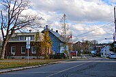
Lorraine is an affluent off-island suburb of Montreal, in southwestern Quebec, Canada on the north shore of the Rivière des Mille-Îles in the Thérèse-De Blainville Regional County Municipality. There are no industries and only a very limited commercial district ; almost all houses are of the detached type. Furthermore, a large portion of the town territory is set aside as wild forest ; some bike/ski trails run through it. The town is divided into two areas, Uptown and Downtown. These two areas are also delimited by Quebec freeway A-640, and are only joined together by the main street overpass.

<span class="mw-page-title-main">Oka, Quebec</span> Municipality in Quebec, Canada

Oka is a small village on the northern bank of the Ottawa River, northwest of Montreal, Quebec, Canada. Located in the Laurentians valley on Lake of Two Mountains, where the Ottawa has its confluence with the St. Lawrence River, the town is connected via Quebec Route 344. It is located 50 km west of Montreal.

<span class="mw-page-title-main">Chomedey, Quebec</span> City and Administrative region in Quebec, Canada

Chomedey is a district in the southwest of the city of Laval and was a separate municipality until the municipal mergers in 1965.

<span class="mw-page-title-main">Fabreville, Quebec</span>

Fabreville is a district in Laval, Quebec. It was a separate city until the municipal mergers on August 6, 1965.

<span class="mw-page-title-main">Bois-des-Filion</span> City in Quebec, Canada

Bois-des-Filion is an off-island suburb of Montreal, located in Quebec, Canada, to the north of Montreal.

<span class="mw-page-title-main">Sir Wilfrid Laurier School Board</span>

The Sir Wilfrid Laurier School Board is a school board headquartered in Rosemère, Quebec in Greater Montreal.
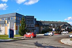
<span class="mw-page-title-main">Sainte-Marthe-sur-le-Lac</span> City in Quebec, Canada

Sainte-Marthe-sur-le-Lac is an off-island suburb of Montreal, in the Canadian province of Quebec, in the Deux-Montagnes Regional County Municipality, 40 km from Montreal. It is crossed from east to west by Route 344, commonly known as Oka Road. The town shares its borders with Deux-Montagnes to the east, Saint-Joseph-du-Lac to the west, the Lake of Two Mountains to the south, and Saint-Eustache to the north.

<span class="mw-page-title-main">Pointe-Calumet</span> Municipality in Quebec, Canada

Pointe-Calumet is a municipality in the Canadian province of Quebec. The municipality is located within the Deux-Montagnes Regional County Municipality in the Laurentides region. It is situated about 30 minutes northwest of Montreal. Its population as of the 2006 Canadian Census is just over 6 000.

<span class="mw-page-title-main">Mille-Isles</span> Municipality in Quebec, Canada

Mille-Isles is a municipality in the Laurentides region of Quebec, Canada, part of the Argenteuil Regional County Municipality, west of Saint-Jérôme.

<span class="mw-page-title-main">Saint-Placide, Quebec</span> Municipality in Quebec, Canada

Saint-Placide is a municipality in the Laurentides region of Quebec, Canada, part of the Deux-Montagnes Regional County Municipality, along the north shore of the Ottawa River.

<span class="mw-page-title-main">Saint-Joseph-du-Lac</span> Municipality in Quebec, Canada

Saint-Joseph-du-Lac is a municipality in the Laurentides region of Quebec, Canada, part of the Deux-Montagnes Regional County Municipality.

The Commission scolaire de la Seigneurie-des-Mille-Îles (CSSMI) is a former francophone school district in the Canadian province of Quebec. It comprises several primary schools and high schools across municipalities in the Laurentides region. The commission is overseen by a board of elected school trustees.

References

  1. "Mirabel". Geographical Names Data Base . Natural Resources Canada.
  2. "Mirabel". Geographical Names Data Base . Natural Resources Canada.
  3. "Banque de noms de lieux du Québec: Reference number 72473". toponymie.gouv.qc.ca (in French). Commission de toponymie du Québec.
  4. 1 2 "Répertoire des municipalités: Geographic code 74005". www.mamh.gouv.qc.ca (in French). Ministère des Affaires municipales et de l'Habitation.
  5. 1 2 3 4 "2021 Community Profiles". 2021 Canadian Census . Statistics Canada. February 4, 2022. Retrieved 2023-10-19.
  6. "Mirabel (ville)" (in French). Commission de toponymie du Québec. Archived from the original on 2016-03-03. Retrieved 2009-03-10.
  7. "Montréal–Mirabel International Airport]". Canadian Climate Normals 1981−2010. Retrieved 2016-05-12.
  8. 1 2 Statistics Canada: 1996, 2001, 2006, 2011, 2016, 2021 census
  9. "Population and dwelling counts: Canada, provinces and territories, and census subdivisions (municipalities), Quebec". Statistics Canada. February 9, 2022. Retrieved August 29, 2022.
  10. "2016 Community Profiles". 2016 Canadian Census . Statistics Canada. August 12, 2021. Retrieved 2022-04-28.
  11. "2011 Community Profiles". 2011 Canadian Census . Statistics Canada. March 21, 2019. Retrieved 2014-04-12.
  12. "2006 Community Profiles". 2006 Canadian Census . Statistics Canada. August 20, 2019.
  13. "2001 Community Profiles". 2001 Canadian Census . Statistics Canada. July 18, 2021.
  14. Government of Canada, Statistics Canada (2022-02-09). "Profile table, Census Profile, 2021 Census of Population - Mirabel, Ville (V) [Census subdivision], Quebec". www12.statcan.gc.ca. Retrieved 2023-01-17.
  15. Government of Canada, Statistics Canada (2013-05-08). "2011 National Household Survey Profile - Census subdivision". www12.statcan.gc.ca. Retrieved 2023-01-17.
  16. https://www12.statcan.gc.ca/census-recensement/2021/dp-pd/prof/details/page.cfm?LANG=E&GENDERlist=1&STATISTIClist=1,4&DGUIDlist=2021A00052474005&HEADERlist=0&SearchText=Mirabel}
  17. "Admission et inscription Archived 2015-01-31 at the Wayback Machine ." Commission scolaire de la Seigneurie-des-Mille-Iles. Retrieved on December 7, 2014. "La Commission scolaire de la Seigneurie-des-Mille-Iles (CSSMI) offre ses services aux résidents des municipalités de : Blainville, Boisbriand, Bois-des-Filion, Deux-Montagnes, Lorraine, Mirabel (Saint-Augustin, Saint-Benoît, Sainte-Scholastique et secteur du Domaine-Vert), Oka, Pointe-Calumet, Rosemère, Sainte-Anne-des-Plaines, Sainte-Marthe-sur-le-Lac, Sainte-Thérèse, Saint-Eustache, Saint-Joseph-du-Lac, Saint-Placide et Terrebonne Ouest."
  18. "Accueil." École primaire de la Clé-des-Champs. Retrieved on December 8, 2014.
  19. "des Blés-Dorés." Commission scolaire de la Seigneurie-des-Mille-Iles. Retrieved on September 20, 2017.
  20. "Girouard." Commission scolaire de la Seigneurie-des-Mille-Iles. Retrieved on December 8, 2014.
  21. "Prés fleuris." Commission scolaire de la Seigneurie-des-Mille-Iles. Retrieved on December 8, 2014.
  22. "Sainte-Scholastique." Commission scolaire de la Seigneurie-des-Mille-Iles. Retrieved on December 8, 2014.
  23. "Répertoire des aires de desserte par ville 2017 - 2018 (Généré le 1/9/2017) Ville Mirabel Archived 2017-09-20 at the Wayback Machine ." Commission scolaire de la Seigneurie-des-Mille-Iles. Retrieved on September 20, 2017.
  24. "Trouver une école ou un centre." Commission scolaire de la Rivière-du-Nord. Retrieved on September 24, 2017. For attendance boundary information, click "Par bassin d'école"
  25. "Préscolaire / primaire." Commission scolaire de la Rivière-du-Nord. Retrieved on December 7, 2014.
  26. "Overview." Lake of Two Mountains High School. Retrieved on December 8, 2014.
  27. "LAKE OF TWO MOUNTAINS HS ZONE Archived 2017-09-04 at the Wayback Machine ." Sir Wilfrid Laurier School Board. Retrieved on September 4, 2017.
  28. "LAURENTIAN REGIONAL HS ZONE Archived 2010-12-14 at the Wayback Machine ." Sir Wilfrid Laurier School Board. Retrieved on September 4, 2017.
  29. "Rosemere High School Zone Archived 2016-03-04 at the Wayback Machine ." Sir Wilfrid Laurier School Board. Retrieved on December 8, 2014.
  30. "Laurentia Elementary School Zone Map Archived 2014-12-11 at the Wayback Machine ." Sir Wilfrid Laurier School Board. Retrieved on December 7, 2014.
  31. "Mountainview Elementary School Zone Map Archived 2014-12-11 at the Wayback Machine ." Sir Wilfrid Laurier School Board. Retrieved on December 8, 2014.
  32. "Saint Jude Elementary School Zone Map Archived 2014-12-11 at the Wayback Machine ." Sir Wilfrid Laurier School Board. Retrieved on December 8, 2014.
  33. "PIERRE ELLIOT TRUDEAU ELEMENTARY ZONE Archived 2017-09-16 at the Wayback Machine ." Sir Wilfrid Laurier School Board. Retrieved on September 16, 2017.